Search results
Query: cq zone
Links: 30 | Categories: 0
-
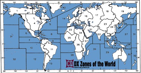
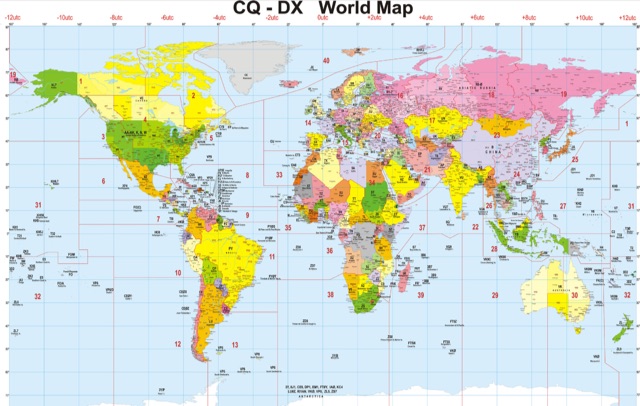
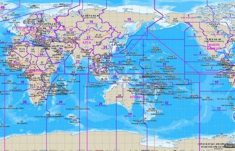 The website provides a free to download large Jpeg DXCC map with amateur radio prefixes and CQ zones. It is a valuable resource for radio amateurs looking to identify DX entities and zones for their operations.
 -
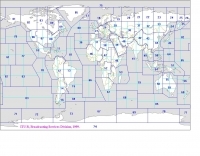
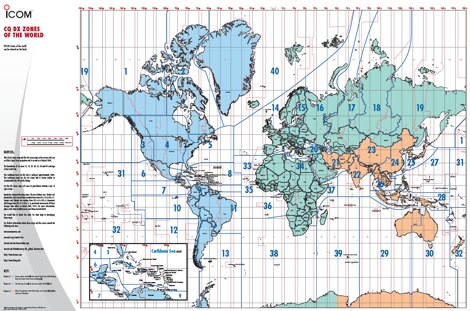 A 6 Mb PDF file of CQ Zones and ITU Zones and prefixes made available to download by Icom America.
 -
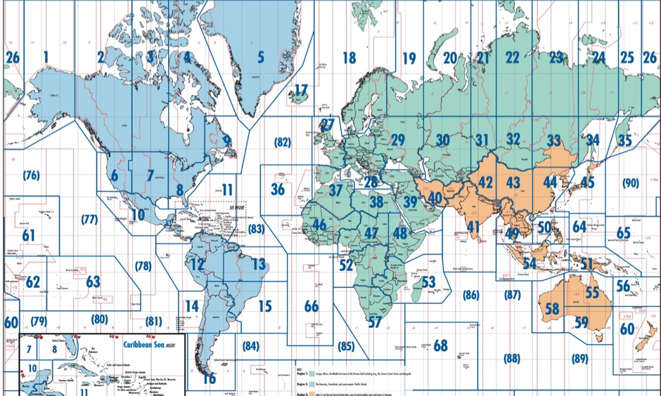
 A large jpeg DX World map that include ITU Zones, grid squares and prefixes. This high-resolution DX World Map is an essential tool for amateur radio operators. It clearly displays ITU zones, CQ zones, grid squares (Maidenhead Locator), and DXCC prefixes, helping you to plan QSOs, track propagation paths, and participate in global contests. Whether you are a seasoned DXer or a beginner, this map provides a clear, detailed view of the radio world, improving your station's efficiency and geographic awareness. Available in JPEG format, it's perfect for display
 -
 Electronic World atlas for radio amateurs. DXCC and province prefixes, CQ and ITU Zones in the rectangular and azimuthal projections, continuous zoom and scrolling, Gray Line, city and island index, unique hierarchical prefix database. COM/OLE Automation for easy integration with 3-rd party programs.
 -
 DXMaps.com presents a dynamic, real-time mapping service for amateur radio DX spots, integrating data from traditional DX clusters, _PSK Reporter_, and WSPR networks. The platform visually plots global QSO and SWL activity, enabling users to observe propagation conditions across various bands, from 2200m to >450 MHz. It offers distinct overlays such as the magnetic equator, gray line, moon footprint for EME, and VOACAP propagation predictions, providing a comprehensive view of radio wave behavior. The service allows granular filtering of displayed spots, including options to show only DX-Cluster data, PSK Reporter activity, or WSPR signals. Users can refine the map view by selecting specific bands (e.g., 160m, 20m, 6m, 2m), limiting spots to the last 15 minutes, or displaying only contacts exceeding **2600 km**. Additional features include the ability to toggle grid squares, aurora forecasts, and various amateur radio zones (CQ, ITU). Distinctively, the resource updates automatically every minute, ensuring current propagation intelligence without manual refresh. It also supports specialized views for EME, ionospheric scatter, and aircraft scatter, alongside FM DX and APRS activity. The platform emphasizes the importance of accurate locator information in DX spots to enhance data quality and offers a user manual and FAQ for guidance.
 -
 The ITU and CQ Zones Map is a printable two-page PDF provided by Icom, displaying the world divided into ITU and CQ Zones. The purpose is to assist radio amateurs in identifying and understanding these zones for communication purposes.
 -
 A large collection of amateur radio maps, including CQ and ITU Zones, a complete set of ham radio Prefix Maps, grid locators and time zones map. An excellent ham radio mapping service.
 -
 Over 70 international contests are supported by YPlog, a Windows-based logging and radio control program designed for amateur radio operators. This software integrates with various digital mode applications like _WinPSK_, _HamScope_, and _MMTTY_, facilitating partially automated log entry for modes such as PSK31, CW, and RTTY. It provides comprehensive logging capabilities including QSL label printing, beam headings, and dup-checking, alongside award tracking for DXCC, ITU/CQ zones, IOTA, Grid Locators, and Counties. The program offers advanced contesting features, including multi-multi or multi-2 networked operations with automatic log data sharing, multiple Cabrillo submission formats, and configurable CW keyboard layouts. Device support extends to TR-compatible CW keying, SO2R control with Top-Ten devices like the DX-DOUBLER, and internal W9XT digital voice keyer integration. YPlog is notable for its support of the _OK1RR DXCC_ country resolution files, providing a robust historical DX compendium. Beyond logging, YPlog includes two freeware utilities: one for computing design parameters for coaxial traps and another for displaying and printing azimuth and Mercator maps from the operator's QTH. The software runs on Windows 95/98/ME/NT/2K, with a recommended screen resolution of 1024x768. Registration costs **$50.00 US** to unlock all features, including full contesting capabilities and rotator control.
 -
 Free Donwload of the PDF file of ITU and CQ zones of the world, made available by Icom America
 -
-
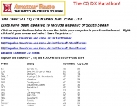 Official, and updated CQ Magazine Countries and Zone List available in various formats, text, word and excel formats.
 -
 Over 47 full-screen maps are available within _NAOMI_ (North American Overlay Mapper), a free Windows program designed for US and Canadian amateur radio enthusiasts. This mapping suite includes 9 backgrounds such as CQ Zones, ITU Zones, and ARRL Sections, along with 16 foreground layers like Counties, Areacodes, and Grid Locators. Users can calculate distances and bearings, track real-time mouse positions with continuous Grid-Locator data, and integrate with APRS for live station tracking via the FindU database. For a global perspective, the _Global Overlay Mapper_ (GOM) provides a world map, 8 continental maps, and 29 sub-continental maps, all with 12 active layers including Country Outlines, CQ/ITU Zones, and Prefix information. Both NAOMI and GOM offer feature-locate systems to jump to positions based on prefixes, capital cities, or Grid Locators, and provide customized beam headings and distance displays. The site also features _LogView_, a post-contest log visualization tool that analyzes Cabrillo-format logs by plotting QSOs on maps, supporting over 30 major contests like CQWW and ARRL DX, and allowing comparison with published results.
 -
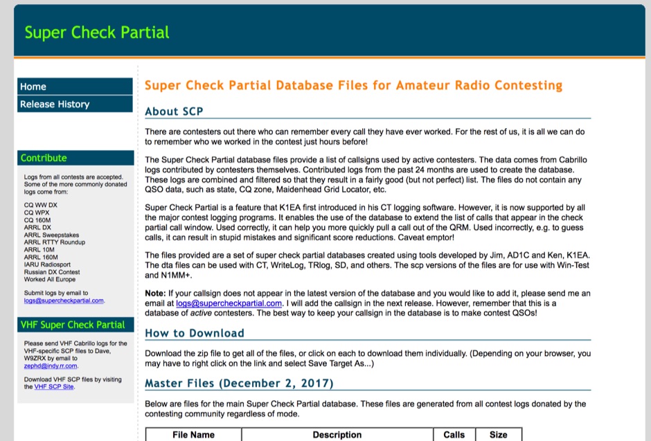 The Super Check Partial database files provide a list of callsigns used by active contesters. The data comes from Cabrillo logs contributed by contesters themselves. Contributed logs from the past 24 months are used to create the database. These logs are combined and filtered so that they result in a fairly good (but not perfect) list. The files do not contain any QSO data, such as state, CQ zone, Maidenhead Grid Locator, etc. The dta files can be used with CT, WriteLog, TRlog, SD, N1MM Logger, NA, Win-Test, and others
 -
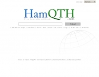 Presents _HamQTH_, a free online callbook and callsign server, which provides rapid XML access for various logging programs, enabling seamless integration for amateur radio operators. The service includes features such as recent activity logs, propagation predictions, and support for multiple languages, making it a versatile tool for DXers and contesters. It also offers detailed information on callsigns, including US states, counties, IOTA, WAZ, and ITU zones. Users can leverage _HamQTH_ for efficient log searching and to monitor current band conditions, aiding in planning DX operations and contest strategies. The platform's XML interface facilitates automated lookups, streamlining the process of identifying stations and gathering essential QTH data. Petr Hlozek, OK2CQR, developed this resource, reflecting practical experience in amateur radio data management.
 -
 Explore this high-resolution ITU Zones Map, a critical reference resource for amateur radio operators, international broadcasters, and telecommunications engineers. Originally established by the International Telecommunication Union – Radiocommunication Sector (ITU-R) Broadcasting Services Division (1999), this chart accurately divides the globe into 90 specific CIRAF zones. This authoritative visual guide is indispensable for planning High Frequency (HF) radio propagation, scheduling international broadcasts, and verifying locations for radio contests and awards. Distinct from the 40 CQ Zones, the ITU zoning system provides the official administrative framework used for global frequency management. This digitally enhanced version ensures maximum clarity of zone boundaries and numbering (e.g., Zone 28 for Central Europe), making it an essential tool for technical accuracy in logbooks and station management. It serves as a trustworthy standard for educators, hobbyists, and industry professionals alike.
 -
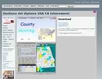 The County Hunting software, version **6.1**, is designed for amateur radio operators focused on USA-CA Award tracking and logging. This application supports _Windows_ environments and facilitates the import and export of ADIF files, enhancing QSL management by integrating electronic confirmations via LoTW and e-QSL. The software has been updated to align with the new award rules managed by MARAC, following the discontinuation of CQ magazine's involvement. Users can visualize QSLs post-scanning and benefit from enhanced ADIF import functionality. Version 5.4 introduced accelerated county searches via FCC databases, with filters for QSL confirmations and e-QSL enhancements. The software also includes a feature for backing up and restoring QSOs by LoTW confirmations. Visual County tools have been refined, offering improved map interactions and the addition of county flags. The software supports various digital modes including FT8, FT4, and SSTV, and includes functionality for PSK250 and 60m bands. The application is multilingual, with support for Italian, English, French, and Spanish, and provides automated updates and web-based county searches. DXZone Focus: County Hunting | ADIF | Windows | LoTW
 -
 Rules of CQ World Wide RTTY Contest. The CQ World Wide RTTY DX Contest take place last full week-end of September, inviting amateur radio operators globally to connect across various CQ zones and countries. Participants will operate on five designated bands: 3.5, 7, 14, 21, and 28 MHz, exchanging RST reports and zone numbers. Scoring is based on QSO points multiplied by zone, country, and QTH multipliers. The contest encourages innovation in operating strategies while adhering to established rules to ensure fair competition among entrants.
 -
 Simply work as many countries and CQ Zones as you can in each calendar year, regardless of the band or mode
 -
-
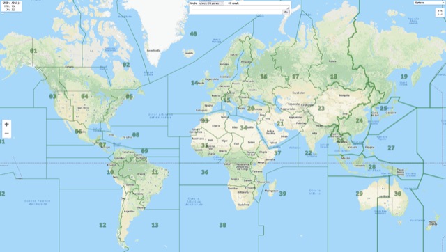 Show CQ and ITU Zone in an interactive clickable map based on google maps. Additional locator tool tip can be displayed by clicking on points, and a search function it is also available to locate addresses, and locators.
 -
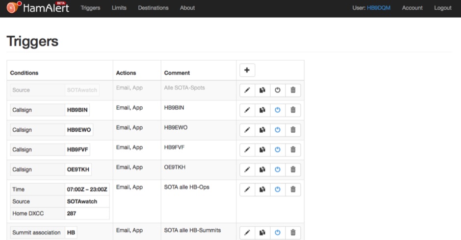 HamAlert let you receive Push,SMS,Email notifications for Cluster,RBN,SOTAwatch spots, with customizable filtering based on many criteria including DXCC, SOTA and WWFF references, CQ zones
 -
 Mircules HAM QuickLog provides a mobile logging solution for amateur radio operators, supporting quick contact entry on iOS and Android platforms. It features multiple log file management, instant callsign information display including Country, ITU zone, CQ Zone, and DXCC number, and robust ADIF and CSV import/export capabilities. The application is designed for efficient logging with optional fields and default values, streamlining the process for both shack and field operations. The software includes dedicated support for POTA, SOTA, and IOTA activations through specific fields like MY_SIG_INFO, SIG_INFO, MY_SOTA_REF, IOTA, and MY_IOTA. A specialized contest mode offers real-time dupe checking and automatic TX exchange updates to enhance contest efficiency. Integration with QRZ.COM and HAMQTH.COM allows for direct operator information lookup and import, while Open Street Maps integration provides geographic context for contacts. The application also features a notes and scratchpad function for each log file.
 -
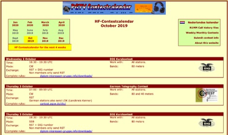 The PG7V Contest Calendar provides a curated listing of significant **HF contests**, with a particular focus on events relevant to European amateur radio operators. It details contest specifics such as start and end times in UTC, eligible bands (e.g., 80 meters, 40 meters, 10 meters), and required exchange information (e.g., serial number, CQ-zone, DOK, locator, age). The calendar includes diverse modes like CW, SSB, PSK63, RTTY, and FT4, catering to various operating preferences. Featured contests include the RSGB 80m Club Championship, WW WPX Contest, IARU Region 1 Fieldday, and ARRL International Digital Contest. Each entry links directly to the official contest rules for detailed information. The calendar also notes specific participation rules, such as the 1 KHz QSY requirement in the HA3NS Memorial Contest or the 24-hour single-operator time limit in the ARRL International Digital Contest. This resource is updated regularly, ensuring timely information for upcoming **contest operations** over a four-week period. It serves as a practical tool for hams planning their contest activity.
 -
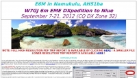 W7GJ 6m EME DXpedition to Niue September 7-21, 2012 CQ DX Zone 32
 -
 Over 15 amateur radio bands, from 160m to 70cm, are supported by the _DXTRON_ web cluster, providing real-time DX spotting information. This service integrates directly with the _QRZCQ_ API, allowing users to monitor activity across various modes including CW, Phone, Digi, RTTY, SSTV, and SAT. DXTRON displays critical spot data such as timestamp, spotter callsign, frequency, mode, DX call, and remarks, along with geographical details like Grid, DXCC, ITU, CQ zone, continent, and country. Developed by _DO5SSB_, DXTRON v1.42 offers a user-friendly interface for filtering spots by band and mode, catering to both casual DXers and serious contesters. The platform is designed for accessibility, providing a clear overview of current propagation conditions and active stations worldwide. This web cluster is a practical tool for hams seeking to identify rare DX, track contest activity, or simply observe band conditions. Its reliance on the QRZCQ API ensures a consistent flow of up-to-date spotting data, making it a reliable resource for real-time operational awareness.
 -
 Optimizing a QRZ.com page involves adding essential callsign data, ensuring correct _Maidenhead Gridsquare_ and DXCC information in the Detail tab, and populating the Biography section with relevant station details. Operators should include their operating conditions, specific country references like WAB square, club affiliations, and detailed QSL information, specifying preferences for electronic confirmations (e.g., _LoTW_, Clublog) and paper QSLs (direct, bureau, SASE). The guide emphasizes the importance of accurate data for electronic logging software integration, which fetches Gridsquare, DXCC, and CQ/ITU zones to populate contact logs correctly. Further enhancements include leveraging the QRZ.com photo gallery for images and setting a primary image that logging software like _Log4OM_ can display. Advanced customization involves embedding external services via HTML source code. Examples include integrating HamAlert for DX Cluster spots, Clublog for log searches and Online QSL Requesting (OQRS), and Parks on the Air (POTA) statistics widgets from WD4DAN. Additionally, live weather information from Weather&Radar and solar data banners from HamQSL can be embedded, providing real-time environmental context for visitors to the QRZ page. These embedded tools require creating accounts on respective platforms and often involve copying specific source code snippets into the QRZ biography's HTML editor, ensuring callsign placeholders are updated.
 -
 Open source code to add CQ Zone, ITU Zone and Maidenhead Locator to your leaflet maps.
 -
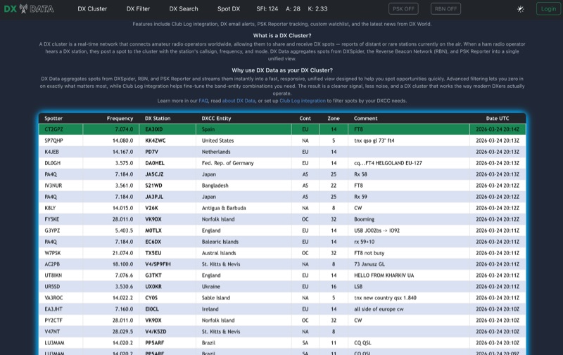 DX Data provides a unified view of real-time DX spots, aggregating data from **DXSpider**, the **Reverse Beacon Network (RBN)**, and PSK Reporter. This online service offers advanced filtering capabilities, allowing amateur radio operators to refine spot displays by DXCC entity, band, mode, CQ zone, and continent. It addresses the challenge of sifting through numerous DX spots by presenting a consolidated stream, enabling DXers to efficiently identify active stations across various bands and modes. The platform integrates with Club Log, which assists in fine-tuning band-entity combinations based on a user's logging history, thereby reducing irrelevant spot noise. Key features include DX email alerts, PSK Reporter tracking, and a custom watchlist for monitoring specific stations or regions. The service also incorporates a live news feed from DX World, providing current information relevant to the DXing community. This design aims to streamline the DX spotting process, offering a responsive interface for identifying operating opportunities.
 -
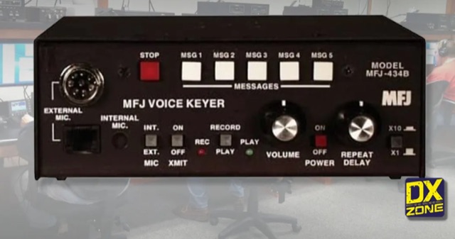 Let this microprocessor controlled MFJ Contest Voice KeyerTM call CQ, send your call and do contest exchanges for you in your own natural voice
 -
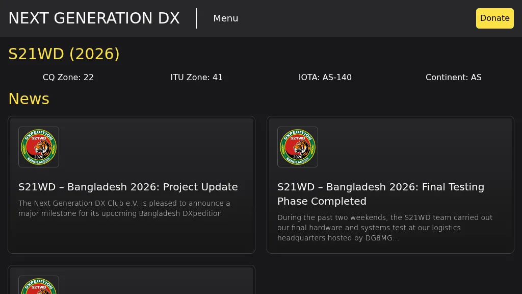 Presents the S21WD DXpedition to Bangladesh (IOTA **AS-140**) scheduled for 2026, organized by the Next Generation DX Club e.V. It outlines the project's progress, including final hardware and systems testing, and the team's successful arrival and activation from the target location. The resource provides a concise summary of Bangladesh, covering its geography, cultural aspects, and economic landscape. The page includes the Clublog Most Wanted ranking for Bangladesh, categorized by continent and mode, as of January 2026. The DXpedition aims to achieve over 70,000 QSOs across CW, SSB, RTTY, and FT8 modes, with a specific focus on RTTY (targeting over 2,000 QSOs) and **lowband** operations. The team plans a Multi-Single entry in the ARRL CW 2026 contest. QSO data will be uploaded to Clublog and LoTW, with Clublog livestream and daily free LoTW uploads anticipated, contingent on stable internet connectivity. The S21WD callsign corresponds to CQ Zone 22 and ITU Zone 41. Further details include a preliminary bandplan, FT8 operating guidelines using MSHV software, a VOACAP DX Prediction link, and an azimuthal map centered on Bangladesh. QSL services are managed by DJ4MX via Clublog OQRS, offering direct, bureau, and LoTW options, with daily LoTW uploads expected.