Search results
Query: uro user
Links: 14 | Categories: 0
-
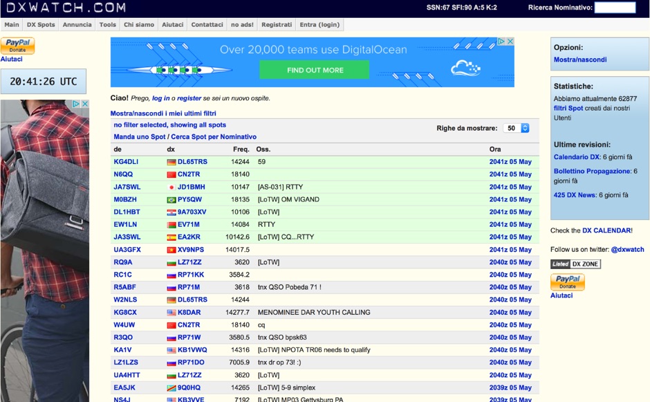 DX clusters aggregate real-time amateur radio spot data, enabling operators to identify active stations and propagation conditions across various bands and modes. DXWatch offers a web-based interface for this essential operating tool, allowing users to filter spots based on specific criteria such as band, mode, or callsign. The service integrates features like a customizable filter system and an external widget for embedding spot data on other platforms, enhancing its utility for DXers and contesters. Operators can access worldwide spot data, with options to zoom into specific regions like the US, Europe, or the North Atlantic, facilitating targeted DXing efforts. The platform also includes a watchlist feature for registered users, enabling personalized tracking of desired stations or entities. Real-time data on solar flux index (SFI), A-index, and K-index are displayed, providing crucial propagation insights alongside the DX spots.
 -
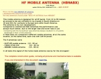 Build your mobile antenna which outperforms Hustler by 10db and ATAS-100 by 18db. From 80 to 10m. The HB9ABX mobile HF antenna, designed for 10 to 80 meters, was developed by Felix Meyer and outperforms commercial antennas like HUSTLER and YAESU ATAS-100/120 in field tests. Made from fiberglass rods and enamelled copper wire, it includes a loading coil with adjustable taps for tuning across bands. Installation requires solid grounding, and adjustments are made via whip length and coil settings. An antenna tuner ensures optimal SWR. Users must handle fiberglass with care due to health risks. This design proved highly effective in South America and Europe.
 -
 DXMaps.com presents a dynamic, real-time mapping service for amateur radio DX spots, integrating data from traditional DX clusters, _PSK Reporter_, and WSPR networks. The platform visually plots global QSO and SWL activity, enabling users to observe propagation conditions across various bands, from 2200m to >450 MHz. It offers distinct overlays such as the magnetic equator, gray line, moon footprint for EME, and VOACAP propagation predictions, providing a comprehensive view of radio wave behavior. The service allows granular filtering of displayed spots, including options to show only DX-Cluster data, PSK Reporter activity, or WSPR signals. Users can refine the map view by selecting specific bands (e.g., 160m, 20m, 6m, 2m), limiting spots to the last 15 minutes, or displaying only contacts exceeding **2600 km**. Additional features include the ability to toggle grid squares, aurora forecasts, and various amateur radio zones (CQ, ITU). Distinctively, the resource updates automatically every minute, ensuring current propagation intelligence without manual refresh. It also supports specialized views for EME, ionospheric scatter, and aircraft scatter, alongside FM DX and APRS activity. The platform emphasizes the importance of accurate locator information in DX spots to enhance data quality and offers a user manual and FAQ for guidance.
 -
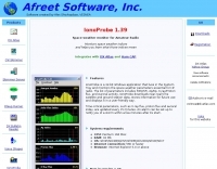 Monitors the space weather parameters essential for HF radio, including SSN/SFI, Ap/Kp, X-ray/Proton flux, and Auroral activity. IonoProbe downloads near-real time satellite and ground station data, stores information for future use and displays it in a user-friendly way.
 -

-
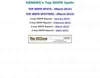 KB9AMG's Top WSPR Spots presents a focused online tool for monitoring **2-way WSPR reports**, specifically detailing propagation data from February 2026 through March 2026. This resource aggregates _WSPRnet_ data, allowing radio amateurs to observe weak signal propagation conditions across various bands. The interface is straightforward, presenting callsigns, frequencies, signal-to-noise ratios, and distances for each reported contact, which is crucial for understanding current band openings and signal paths. The utility of this WSPR spotter lies in its ability to quickly visualize global propagation. Users can identify active stations and assess signal viability over long distances, with reports often showing contacts spanning thousands of kilometers. For instance, a typical WSPR report might indicate a signal from Europe reaching North America with a _SNR_ of -25 dB, demonstrating effective low-power communication. This data is invaluable for planning DX operations or evaluating antenna performance under actual propagation conditions.
 -
 BeaconSpot.uk provides an accurate, real-time picture of microwave and VHF/UHF beacons operating across Europe, alongside a worldwide listing of 6-meter beacons. The platform allows users to retrieve detailed data for individual beacons, facilitating in-depth analysis of signal characteristics and propagation paths. Interactive maps visualize beacon distribution by frequency band and display spot coverage for each station, offering a clear geographical overview of active beacons. The system integrates real-time DXCluster spots, sourced from contributors like Alain, ON4KST, and Pascal, F5LEN, and enables users to submit outgoing spots directly to the DXCluster. Beacon keepers can manage their beacon data, receive email alerts upon being spotted, and track their station's ODX (Outstanding DX) records. For every received spot, the distance to the beacon is automatically calculated and displayed, aiding propagation studies.
 -
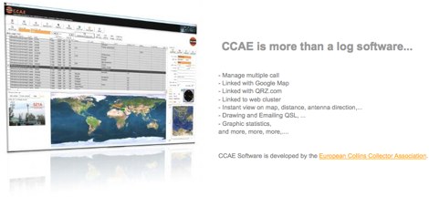 CCAE Software Log provides a dedicated platform for amateur radio operators to manage their QSO records, offering functionalities beyond basic logging. This application supports various operational aspects, including contest participation and general DXing activities, catering to the needs of radio enthusiasts who utilize classic equipment such as Collins radios. The software integrates features for efficient data entry and retrieval, allowing users to maintain a detailed history of their contacts. It is designed to be intuitive for operators focused on collecting and preserving their radio communication logs. The program's development by the European Collins Collector Association (F6HOY) suggests a focus on reliability and specific utility for vintage radio enthusiasts. Its core function is to serve as a robust **logbook software**, facilitating organized record-keeping for ham radio operations.
 -
 DX Maps provides a specialized map printing service, focusing on amateur radio applications such as world prefix maps and custom great circle projections. The platform allows radio operators to visualize propagation paths and DX entities relevant to their QTH and operational goals. This service supports the creation of high-quality, large-format maps tailored for shack display or operational planning. The service facilitates the generation of personalized maps, which can include specific callsign locations, beam headings, and other critical amateur radio data points. Users can specify parameters to create maps that aid in understanding global propagation conditions and optimizing antenna aiming for long-distance contacts. The UK-based operation ensures a localized service for European hams, with international shipping options available. DX Maps also offers QSL card printing, complementing its mapping services.
 -
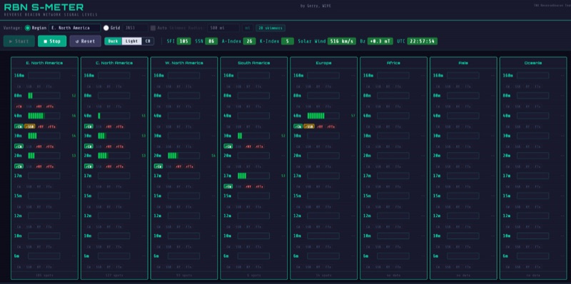 The RBN S-Meter visualizes real-time HF propagation data from the Reverse Beacon Network (RBN). It processes thousands of automated spots per hour, providing a real-time picture of active RF paths on HF bands. Users can set their vantage point using _Region Mode_ or _Grid Square Mode_. Region Mode allows selection from broad geographic areas like E. North America or Europe, while Grid Square Mode uses a Maidenhead grid square and radius for more precise data. The app displays eight region panels, each with horizontal bars for bands 160m through 6m, indicating signal strength with a color ramp from green to red. A dimmer trail shows peak hold values, and an S-unit readout provides additional detail. The app is a free web application accessible on any device, offering a practical tool for ham radio operators interested in CW, RTTY, and FT8 signals. It features a Progressive Web App installation option for enhanced usability on mobile and desktop platforms. Users can install it on Android, iOS, and Windows devices, providing a native app-like experience. The app replaces the previous Windows standalone executable, incorporating user feedback to improve features like grid square mode and automatic location detection.
 -
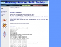 Over 100 currently valid callsigns for the Bailiwick of Guernsey are listed, encompassing full, intermediate, and foundation licenses, alongside special event and club station calls. The resource clarifies various callsign types, such as 2U0*** for intermediate licensees with a 50-watt limit and GU0*** for full licensees operating up to **400 watts**. This detailed compilation also includes specific QSL routing instructions for visiting operators and past residents, often referencing their home callsigns like _G4DIY_ or _DJ8NK_. The callbook further acknowledges "silent keys," providing a respectful record of former Guernsey amateurs, complete with their callsigns and dates of passing where available. It also lists local repeaters and provides important QSL bureau information, noting that only US dollar bills are accepted for direct QSLs, not English stamps or Euros. For full addresses, the resource directs users to _QRZ.com_, emphasizing that the provided information is offered in good faith.
 -
 Approximately 100 MeshCom nodes are visualized in real-time on a geographical map, providing a dynamic overview of the LoRa mesh network. This resource, hosted by _OE1KFR_, details node positions, telemetry data, and message traffic. Users can measure distances between two selected nodes, view text messages with callsign, destination, and gateway information, and access position data including latitude, longitude, and altitude. The platform supports filtering by regions such as Europe, USA, and Asia, allowing operators to focus on specific geographical areas. The detailed node list table presents comprehensive status information for each node, including gateway callsign, firmware version, hardware type, and environmental telemetry like temperature, pressure, humidity, and CO2 levels. This granular data enables operators to monitor network health and individual node performance, facilitating troubleshooting and optimization of MeshCom deployments. The map interface enhances situational awareness for those engaged in LoRa mesh networking.
 -
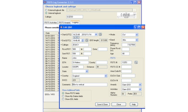 FISTS Log Converter simplifies various tasks for amateur radio operators. It aids in tracking FISTS Awards, submitting applications, and creating logs for FISTS Activities in Europe like the Ladder and EuCW Snakes & Ladders. Users can generate callsign checklists and import logs from existing logging programs via ADIF files. Available as freeware, it runs on Windows 2000 and later versions
 -
 Presents detailed expedition charts and statistics for the **XX9W** DXpedition, covering operating time, total QSOs, unique calls, and duplicate QSOs. The resource provides comprehensive band and mode breakdowns, including FT8, SSB, CW, and FM, across 80m, 40m, 30m, 20m, 17m, 15m, 12m, 10m, 6m, 2m, and 70cm. Users can access DXCC statistics by band and mode, daily QSO totals, and multiband QSO statistics. Continent-by-mode and continent-by-band breakdowns are also available, detailing activity from Africa, Asia, Europe, North America, Oceania, and South America. The platform also tracks the expedition's impact on user totals, showing new band, new mode, new band + new mode, new slot, and new DXCC contacts.