Search results
Query: prediction
Links: 61 | Categories: 3
-
 Zenith Tracker offers real-time satellite tracking, pass predictions, and radio hardware integration for ham radio operators. The platform includes an interactive world map showing satellite positions, footprints, and ground tracks, as well as a polar radar visualization for detailed pass analysis. Users can view upcoming passes, set filters, and receive notifications. Integration with CSN Technologies S.A.T Hardware and QTRigDoppler allows for automatic radio control, antenna tracking, and transponder management. The platform also offers APRS message interface, grid square-based location input, and API integration for rover activations. Zenith Tracker is recommended for both general users and those needing advanced hardware integration.
 -
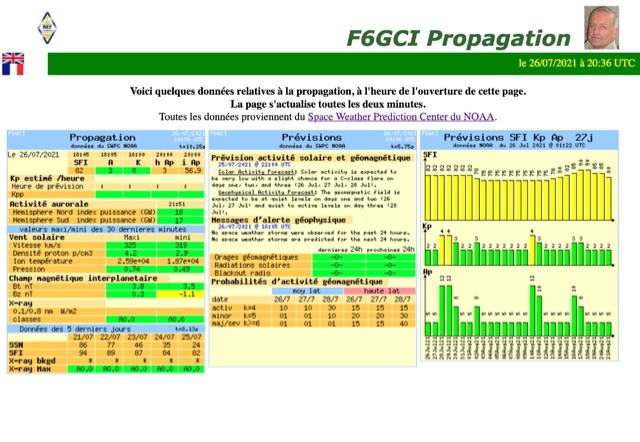 A collection of dynamically produced images based on the daily data of the NOAA Space Weather Prediction Center
 -
 KlaTrack is a Windows-based software application designed to assist amateur radio operators with satellite communication by predicting spacecraft visibility. It provides a simple interface to determine when specific satellites will be above the local horizon, a critical factor for successful two-way contacts via amateur radio satellites. The program processes _Two-Line Element_ (TLE) data to calculate orbital mechanics, offering a practical tool for satellite operators to plan their operating windows. It supports real-time tracking and displays essential pass information. This utility simplifies the complex task of satellite tracking, allowing operators to focus on making contacts rather than manual orbital calculations. While specific gain figures or distances are not quantified, the software's core function directly supports achieving successful satellite QSOs by providing precise pass predictions. It is particularly useful for operators engaging in activities like working the International Space Station (ISS) or other low-Earth orbit (LEO) satellites, where short pass times and precise timing are crucial for maximizing contact opportunities.
 -
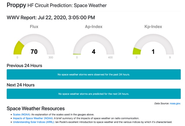 Current space weather condition gauges, with solar indices taken from the latest WWV report
 -
 SkyRoof is an open-source, 64-bit Windows application designed for amateur radio operators and satellite enthusiasts, combining satellite tracking and Software Defined Radio (SDR) functionality in a unified platform. The software provides real-time satellite tracking, pass predictions, and visual representations through Sky View, Earth View, and Timeline displays. It features an SDR-based waterfall display covering VHF/UHF satellite segments with Doppler-corrected frequency scales, automatic satellite labeling, and visual tuning capabilities. SkyRoof supports various SDR devices (Airspy Mini, SDRplay, RTL-SDR), external transceiver CAT control, and antenna rotator integration. The application automatically downloads satellite data from SatNOGS and other sources, offers voice announcements for satellite passes, and includes comprehensive frequency control with Doppler tracking, manual corrections, and RIT functionality for enhanced satellite communication operations.
 -
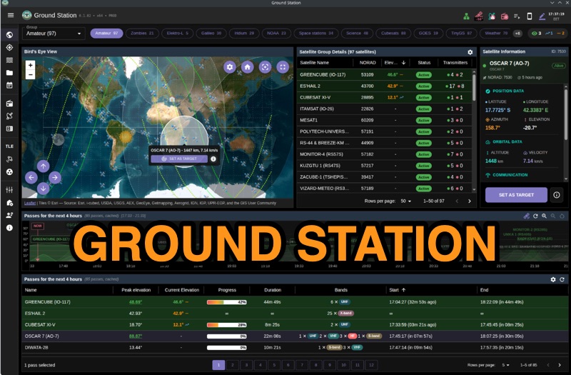 Ground Station offers real-time satellite tracking and radio communication capabilities, primarily for amateur radio operators engaged in satellite operations. It utilizes **TLE data** from sources like CelesTrak and SatNOGS for precise orbital prediction and integrates with various SDR devices, including RTL-SDR, SoapySDR, and UHD/USRP radios, to receive live signals. The software provides automated antenna rotator control and **Hamlib-compatible** rig control with Doppler correction, crucial for maintaining signal lock on fast-moving LEO satellites. It supports IQ recording in SigMF format and decodes several digital modes such as SSTV, FSK, GFSK, GMSK, and BPSK with AX25 USP Geoscan framing. Dedicated interfaces are available for satellite tracking, SDR waterfall displays with live transcription and packet decoding, and telemetry packet viewing. Users can manage TLE data synchronization and SDR hardware, along with browsing decoded outputs through an integrated file browser. An observations dashboard and DSP topology view further enhance the operational experience, providing comprehensive tools for monitoring and analyzing satellite passes.
 -
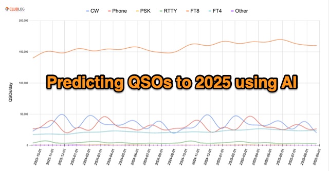 In an innovative analysis, Michael G7VJR employs NeuralProphet to predict ham radio modes' usage trends. The AI model, leveraging deep learning, forecasts a steady FT8 dominance, with slight declines in CW and Phone activities. This approach simplifies statistical predictions, showcasing the power of AI in understanding complex patterns and facilitating insightful time series projections. Access the freely available Club Log data for continuous exploration.
 -
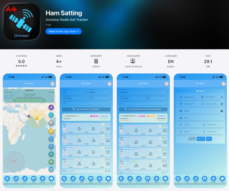 For those engaging with amateur radio satellites, _Ham Satting_ provides a comprehensive, multi-platform application developed by A46UNX. It offers real-time visualization of the ISS and other amateur satellites on an interactive map, ensuring operators always know their current positions. The application delivers detailed pass predictions, including crucial data like AOS, LOS, duration, azimuth, and elevation, which are essential for planning successful satellite contacts. Beyond tracking, Ham Satting integrates a robust QSO logging feature, allowing users to save contacts to a local database with filtering, searching, and export capabilities. A notable addition is the built-in SSTV decoder, supporting various modes such as _Robot 36/72_, Scottie, Martin, and PD, complete with manual fine-tuning controls for optimal image reception. This feature alone can save operators from needing separate software. Developed by Yousuf AL Balushi (A46UNX) out of a personal need for a more integrated solution, Ham Satting is available for iOS, macOS, and Android, with BETA versions for Windows and Linux. His journey into ham radio and satellite operations, beginning in November 2024, directly informed the design, aiming to combine all essential tools into one powerful package.
 -
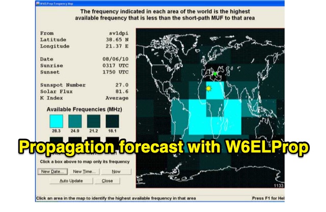 In 2004, Carl Luetzelschwab, K9LA, wrote a guide on using W6ELProp for radio wave propagation predictions. This tutorial, translated for broader accessibility, explains initial setup, configuration, and daily use. It emphasizes using mean solar index values for accuracy, helping users effectively predict and interpret propagation for improved amateur radio operations.
 -
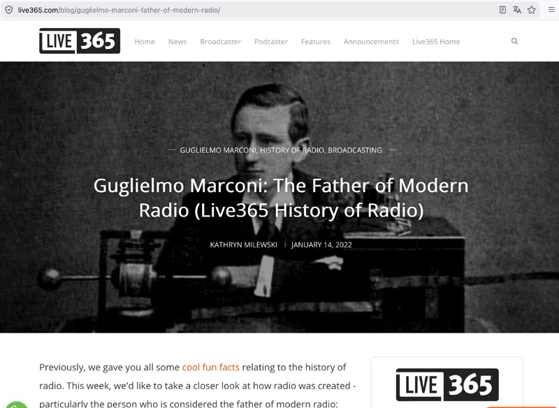 Tracing the foundational work of Guglielmo Marconi, this article details his early laboratory experiments in 1895, where he successfully transmitted wireless signals over 1.5 miles. It highlights his 1896 patent for a wireless telegraphy system in England and subsequent demonstrations, including signal transmissions up to 6.4 km (4 miles) on Salisbury Plain and nearly 14.5 km (9 miles) across the Bristol Channel. Marconi's work built upon the mathematical theories of _James Clerk Maxwell_ and the experimental results of _Heinrich Hertz_, proving the practical feasibility of radio communication. The resource further chronicles the formation of The Wireless Telegraph & Signal Company Limited in 1897 and Marconi's relentless efforts to popularize radiotelegraphy. A significant milestone was the 1901 transatlantic reception of the Morse code letter "S" from Poldhu, Cornwall, at St. John's, Newfoundland, using a kite-supported wire antenna, defying contemporary mathematical predictions about Earth's curvature limiting range. This achievement underscored the global potential of radio. The article also touches upon Marconi's later discoveries, such as the "daytime effect" concerning atmospheric reflection of radio waves, and his 1902 patent for a magnetic detector, which became a standard wireless receiver. His contributions earned him a Nobel Prize in 1909.
 -
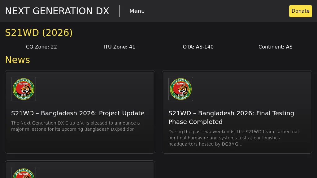 Presents the S21WD DXpedition to Bangladesh (IOTA **AS-140**) scheduled for 2026, organized by the Next Generation DX Club e.V. It outlines the project's progress, including final hardware and systems testing, and the team's successful arrival and activation from the target location. The resource provides a concise summary of Bangladesh, covering its geography, cultural aspects, and economic landscape. The page includes the Clublog Most Wanted ranking for Bangladesh, categorized by continent and mode, as of January 2026. The DXpedition aims to achieve over 70,000 QSOs across CW, SSB, RTTY, and FT8 modes, with a specific focus on RTTY (targeting over 2,000 QSOs) and **lowband** operations. The team plans a Multi-Single entry in the ARRL CW 2026 contest. QSO data will be uploaded to Clublog and LoTW, with Clublog livestream and daily free LoTW uploads anticipated, contingent on stable internet connectivity. The S21WD callsign corresponds to CQ Zone 22 and ITU Zone 41. Further details include a preliminary bandplan, FT8 operating guidelines using MSHV software, a VOACAP DX Prediction link, and an azimuthal map centered on Bangladesh. QSL services are managed by DJ4MX via Clublog OQRS, offering direct, bureau, and LoTW options, with daily LoTW uploads expected.