Search results
Query: king
Links: 136 | Categories: 27
This query is too generic. Please try adding an additional term to focus your research.
Categories
- Operating Modes > Internet Linking
- Software > Awards tracking
- Software > Internet Linking
- Operating Modes > Satellites > Real Time Tracking
- Software > Satellite tracking
- Radio Scanning > Aeronautical
- Software > Antenna rotor control
- Operating Modes > Satellites > AO-51
- Software > Beacon Monitoring
- Operating Modes > Packet Radio > Beginner's Guide
- Software > D-STAR
- DX Resources > DXCC
- Software > EME
- Operating Modes > Ham Radio Balloons
- Operating Modes > Satellites > Hamsat VO-52
- Operating Modes > International Space Station
- Operating Modes > Morse code > Learning Morse Code
- Internet and Radio > News Groups
- Software > Legacy Systems > PalmOS
- Radio Equipment > Scanners > Radio Shack PRO-94
- Radio Equipment > Scanners > Radio Shack PRO-95
- Technical Reference > Repeater > Repeater Maintenance
- Antennas > Satellite
- Ham Radio > Blogs > Europe > UK
- DX Resources > Callsigns > Vanity Call Signs
- Radio Scanning > Weather
- Shopping and Services > WiFi
-
 A ham radio blog primarily focused on newbies and those interested in the hobby. Covers a wide area of subjects that might be of interest to Amateur Radio operators, and material that can be used to study for the Amateur Radio tests.
 -
 Demonstrates the practical application of APRS (Automatic Packet Reporting System) through the lens of HB9PVI's activities in Switzerland. It covers the system's core function of reporting geographical positions and telemetry data from various objects, including mobile stations, aircraft, and the ISS, distributed via packet radio and internet gateways. The resource highlights the routing paradigm shift introduced in April 2005, specifically the recommendation to use _WIDE1-1_ instead of RELAY and WIDE for digipeating to reduce duplicate packets. The page presents real-time maps displaying the positions of amateur radio stations in Switzerland and around Bern, updated every few minutes. It details specific callsigns like _HB9BA-2_ (HB9PVI's home QTH), _HB9BA-8_ (a weather station), and _HB9BA-4_ (a WIDE digipeater on Weissenstein mountain), providing context for their roles within the local APRS network. Links to track HB9PVI's mobile operations (_HB9PVI-9_) and handheld devices (_HB9PVI-15_, _HB9PVI-7_) are also provided. Furthermore, the resource curates a list of APRS software options for various operating systems, including _JavAPRS_ for Europe, _UI-view_, and _X-Astir_ for Linux, alongside digipeater/IGATE software like _DiXPRS_. It also offers downloadable APRS information, including a PDF article by HB9PVI and HE9ZGN, and a PowerPoint presentation in German, making it a repository of practical and historical APRS data.
 -
 Stacking yagi antennas for 50 Mhz band article by by Zaba, OH1ZAA/NN0Y
 -
 Home page for the TARPN node design and promotion. This is an Off-The-Grid Text messaging and educational packet networking project. No Internet required or desired.
 -
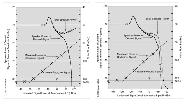 An explanation of the different procedures and definitions that are commonly used for blocking dynamic range (BDR) measurements. Dynamic range in general is the ratio between the weakest signal a system can handle and the strongest signal the same system can handle simultaneously without an operator switching attenuators or turning volume potentiometers
 -
 G1XYZ G3XYZ The Home of Amateur Radio in West Norfolk
 -
 KARS was founded in January 2008 and has grown from strength to strength
 -
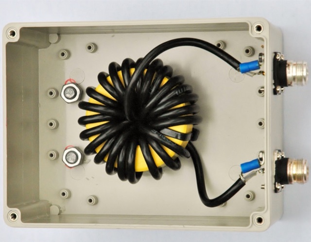 Choking balun for lower HF and MF bands. (1.8MHz - 10MHz). Requiring a choking balun to isolate the potential RF pick up on the coax cable as it runs past equipment such as computer within the radio room at lower HF and MF frequencies a simple method of winding RG58 coax onto a Powdered Iron Toroid Core was constructed.
 -
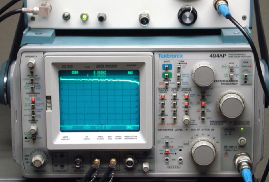 A spectrum analyzer is always an usefull amateur radio test equipment that should be present in a radio shack. Hams can use it for testing frequency response of filters, amplifiers, and other two-port RF devices. This article illustrate a tracking generator compatible with any spectrum analyzer in the Tektronix 490- and 2750-series lineups
 -
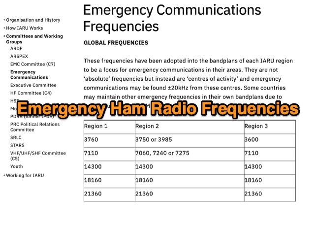 These frequencies have been adopted into the bandplans of each IARU region to be a focus for emergency communications in their areas. They are not absolute frequencies but instead are centres of activity and emergency communications may be found around 20kHz from these centres. Some countries may maintain other emergency frequencies in their own bandplans due to local requirements, QRM etc
 -
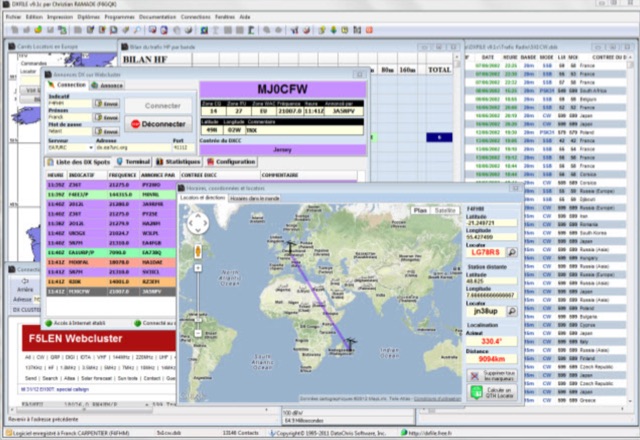 DXFile is a Windows shareware application designed for amateur radio operators, providing comprehensive log management capabilities. The software, developed in Pascal, facilitates real-time and deferred QSO entry, automatically populating fields like frequency, mode, and DXCC country based on user input and system time. It includes features for searching, modifying, and deleting QSO records, with options to sort logs by date, callsign, or entry order. The program offers various printing functions, including QSL card labels in multiple formats, and can generate standard logbook printouts. Beyond basic logging, DXFile integrates modules for tracking progress towards major operating awards such as DXCC, _IOTA_, WAZ, WAS, DDFM, and DIFM. It provides detailed summaries of contacts by band and mode, including graphical representations of HF traffic. A dedicated QSL Manager module assists in processing received QSLs, allowing users to mark confirmations and print multi-line QSL labels. The application also incorporates a DXCC list viewer, which can be updated to ensure accurate country and zone data for logging and award tracking. A distinctive feature is its HF propagation prediction module, which calculates optimal frequencies and signal levels for paths between **250 km** and **6000 km**, considering both E and F layer ionospheric conditions. This module helps operators determine the best times for long-distance contacts. Additionally, DXFile includes a _Web-Cluster_ interface, enabling connection to various DX cluster servers like DXLITE, DXSCAPE, and NC7J for real-time spot information.
 -
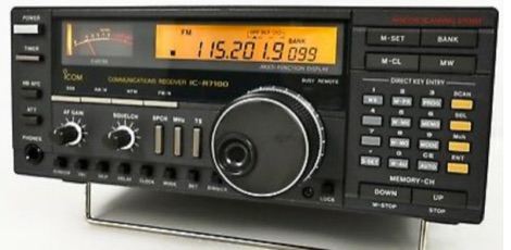 How to solve the problems with the ICOM IC R7100 receiver that every time the squelch opens or closes, it produces a clicking noise.
 -
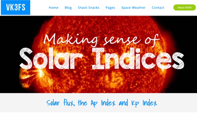 Undesrtanding three band conditions indicators to undestand current and future propagation conditions, solar flux, Ap and Kp indices
 -
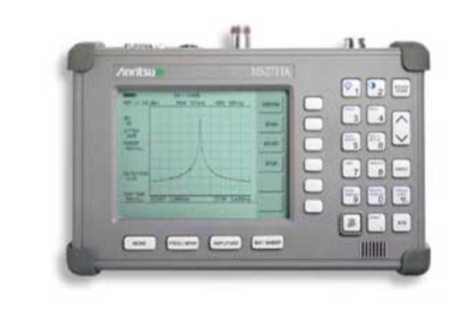 Repairing an Anritsu MS2711A handheld spectrum analyzer
 -
 KlaTrack is a Windows-based software application designed to assist amateur radio operators with satellite communication by predicting spacecraft visibility. It provides a simple interface to determine when specific satellites will be above the local horizon, a critical factor for successful two-way contacts via amateur radio satellites. The program processes _Two-Line Element_ (TLE) data to calculate orbital mechanics, offering a practical tool for satellite operators to plan their operating windows. It supports real-time tracking and displays essential pass information. This utility simplifies the complex task of satellite tracking, allowing operators to focus on making contacts rather than manual orbital calculations. While specific gain figures or distances are not quantified, the software's core function directly supports achieving successful satellite QSOs by providing precise pass predictions. It is particularly useful for operators engaging in activities like working the International Space Station (ISS) or other low-Earth orbit (LEO) satellites, where short pass times and precise timing are crucial for maximizing contact opportunities.
 -
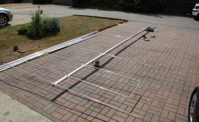 This six element LFA Yagi for six meters has a 1.5 inch square boom with a 1.5 inch secondary boom beneath the first. This ensures the 7.3 metre long boom will not sag and will not require any guying. This antenna has 12.3 dBi Gain and just over 23dB F/B.
 -
 Official web site of URE contests including the King of Spain HF CW and SSB Contest
 -
 SkyRoof is an open-source, 64-bit Windows application designed for amateur radio operators and satellite enthusiasts, combining satellite tracking and Software Defined Radio (SDR) functionality in a unified platform. The software provides real-time satellite tracking, pass predictions, and visual representations through Sky View, Earth View, and Timeline displays. It features an SDR-based waterfall display covering VHF/UHF satellite segments with Doppler-corrected frequency scales, automatic satellite labeling, and visual tuning capabilities. SkyRoof supports various SDR devices (Airspy Mini, SDRplay, RTL-SDR), external transceiver CAT control, and antenna rotator integration. The application automatically downloads satellite data from SatNOGS and other sources, offers voice announcements for satellite passes, and includes comprehensive frequency control with Doppler tracking, manual corrections, and RIT functionality for enhanced satellite communication operations.
 -
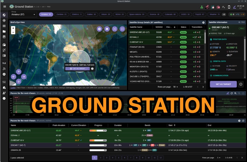 Ground Station offers real-time satellite tracking and radio communication capabilities, primarily for amateur radio operators engaged in satellite operations. It utilizes **TLE data** from sources like CelesTrak and SatNOGS for precise orbital prediction and integrates with various SDR devices, including RTL-SDR, SoapySDR, and UHD/USRP radios, to receive live signals. The software provides automated antenna rotator control and **Hamlib-compatible** rig control with Doppler correction, crucial for maintaining signal lock on fast-moving LEO satellites. It supports IQ recording in SigMF format and decodes several digital modes such as SSTV, FSK, GFSK, GMSK, and BPSK with AX25 USP Geoscan framing. Dedicated interfaces are available for satellite tracking, SDR waterfall displays with live transcription and packet decoding, and telemetry packet viewing. Users can manage TLE data synchronization and SDR hardware, along with browsing decoded outputs through an integrated file browser. An observations dashboard and DSP topology view further enhance the operational experience, providing comprehensive tools for monitoring and analyzing satellite passes.
 -
 DecoAlert 1.0 Beta is a companion application designed to enhance the digital mode operating experience, specifically for FT8, FT4, and FT2. It operates by monitoring UDP data streams from primary decoding software like _Decodium_ and _WSJT-X_ on port 2237. The software provides real-time, priority-based audio alerts using WAV sounds for various conditions, including All Time New Ones (ATNO), new DXCC entities per band/mode, user-defined watchlist callsigns, new Maidenhead grid squares, and LoTW-active stations. It also highlights previously worked stations (B4) and integrates live DX spots from Telnet clusters, offering a comprehensive suite of tools for serious digital mode operators. The application features a built-in SQLite database for tracking worked stations and integrates with LoTW user lists to identify confirmed contacts. A DX Cluster client supports multiple Telnet servers, providing a broad view of propagation. PSKReporter statistics are available by band and mode, offering insights into signal paths. The QSO log viewer includes search and filter capabilities, while an _OpenStreetMap_ (OSM) interface visualizes spot locations, aiding in situational awareness. DecoAlert requires Windows 10/11 (64-bit) and compatible digital mode software configured to send UDP data.
 -
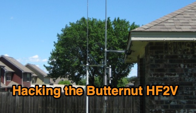 The Butternut HF2V, originally a two-band vertical antenna for 80m and 40m, was enhanced by the user to include 30m and 20m bands for better digimode DX work during the solar minimum. The additions used components adapted from the HF6V and innovative methods for the 20m addition, either through a parallel vertical element or a lower-mounted independent element, minimizing band interaction. This modified four-band antenna now supports high power across popular HF bands using a single feedpoint.
 -
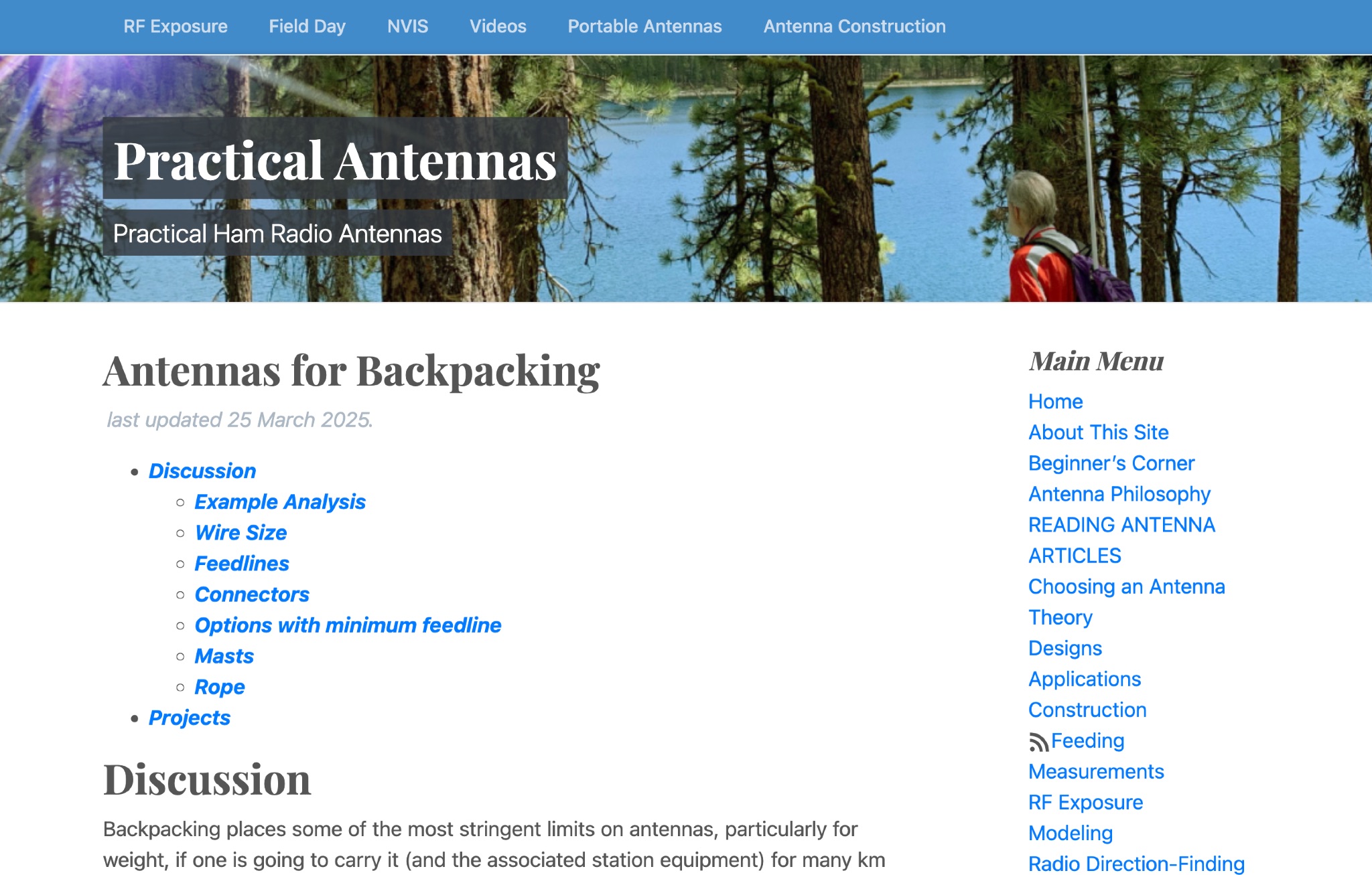 Learn how to choose the right portable antennas for backpacking as a ham radio operator. Find out the factors to consider, including weight, performance, and reliability. Understand the trade-offs involved in selecting the best antenna for your needs, based on the purpose of your trip and distance to be covered. Discover different options available and how they can help you make contacts while on the go. Get insights into one ham radio operator's portable antenna kit and the factors that influenced their choices. Explore the importance of band selection and adaptability in creating a successful antenna system for backpacking adventures.
 -
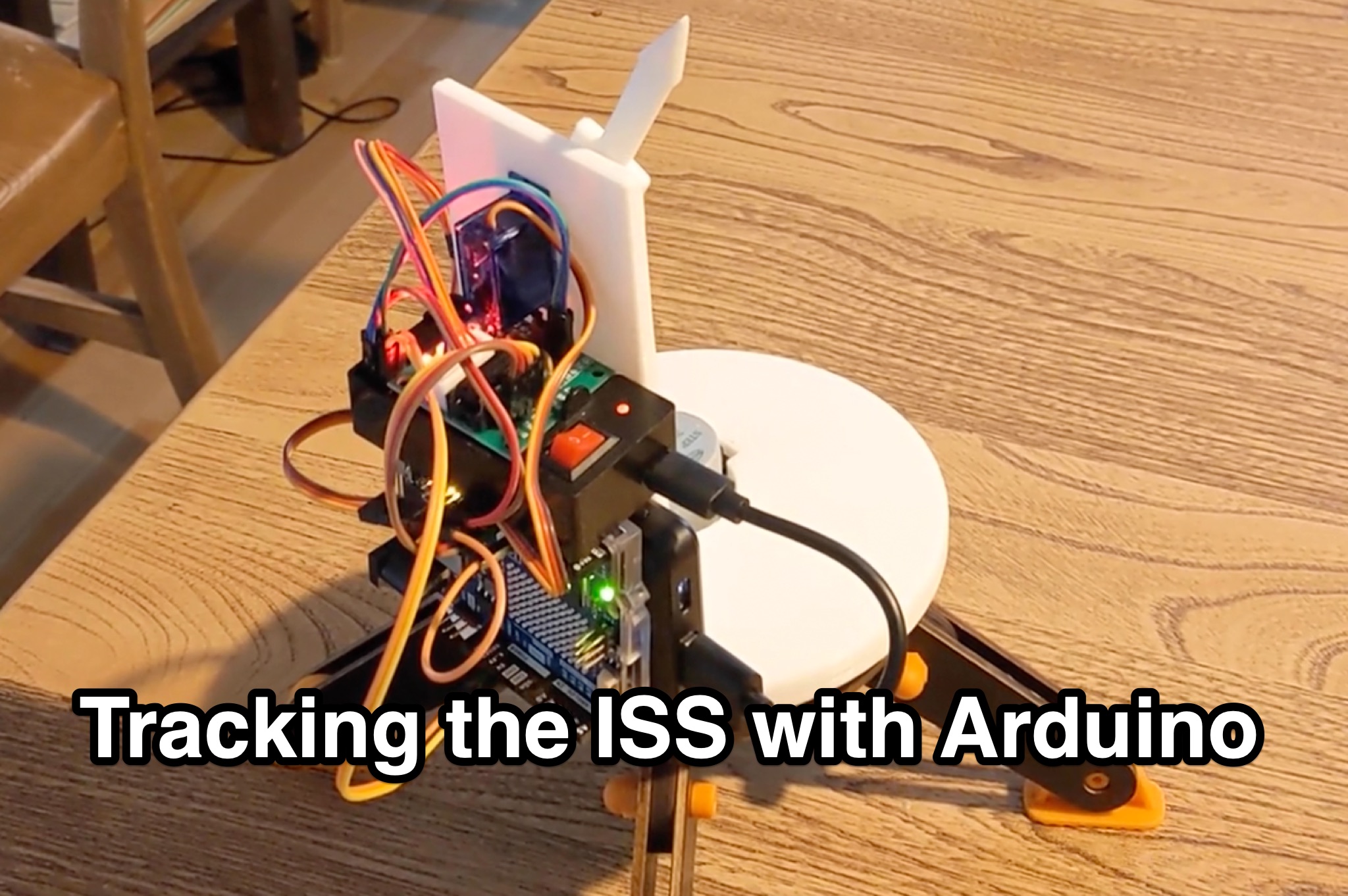 Learn how to hack an IR turret to track the International Space Station (ISS) as it passes overhead. Discover the basics of the ISS and how to use simple tools to point an arrow at the ISS without looking at a phone. Find out how to calculate the azimuth and elevation angles to locate the ISS in the sky and enjoy watching this habitable space craft orbit the earth at a speed of 28,000 km/h. Take your hobby to the next level by bouncing radio signals off the ISS or even talking to the astronauts on board. Turn stargazing into an interactive and educational experience with this fun and practical project.
 -
 When new to the 2-meter FM transceiver, securing a quiet frequency for chatter seems straightforward, but it's essential to navigate FCC rules and band plans effectively. Even though frequency allocations are consistent above 50 MHz for Technician licenses, adherence to specific segments within the 2m band—ranging from 144 MHz to 148 MHz—is crucial. This includes respecting designations for different modes like CW, SSB, and FM to prevent interference, particularly with satellites and exotic modes like EME. Understanding and following the structured band plans not only ensures legal compliance but also optimizes frequency use and minimizes disruptions in the amateur radio community.
 -
 If your FT-817 has stopped powering up from the internal battery but works from external power, then maybe the internal battery fuse has blown. There is a small PCB mounted fuse to protect the battery and radio. This fuse can blow, if it does your radio will not work from battery power. This page will describe how to test the fuse and describe how to make a repair.
 -
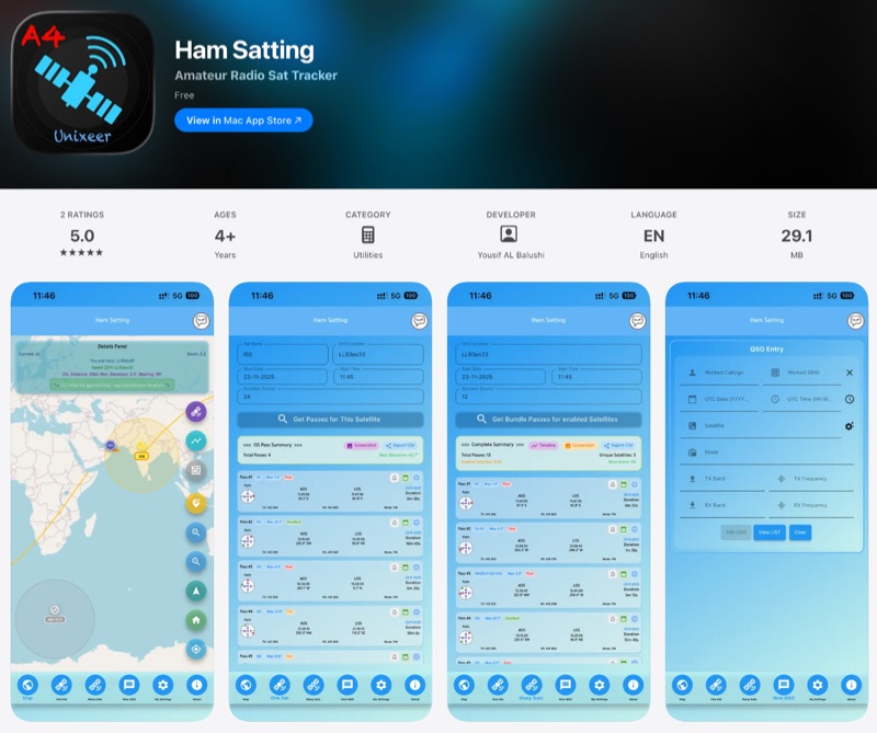 For those engaging with amateur radio satellites, _Ham Satting_ provides a comprehensive, multi-platform application developed by A46UNX. It offers real-time visualization of the ISS and other amateur satellites on an interactive map, ensuring operators always know their current positions. The application delivers detailed pass predictions, including crucial data like AOS, LOS, duration, azimuth, and elevation, which are essential for planning successful satellite contacts. Beyond tracking, Ham Satting integrates a robust QSO logging feature, allowing users to save contacts to a local database with filtering, searching, and export capabilities. A notable addition is the built-in SSTV decoder, supporting various modes such as _Robot 36/72_, Scottie, Martin, and PD, complete with manual fine-tuning controls for optimal image reception. This feature alone can save operators from needing separate software. Developed by Yousuf AL Balushi (A46UNX) out of a personal need for a more integrated solution, Ham Satting is available for iOS, macOS, and Android, with BETA versions for Windows and Linux. His journey into ham radio and satellite operations, beginning in November 2024, directly informed the design, aiming to combine all essential tools into one powerful package.
 -
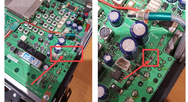
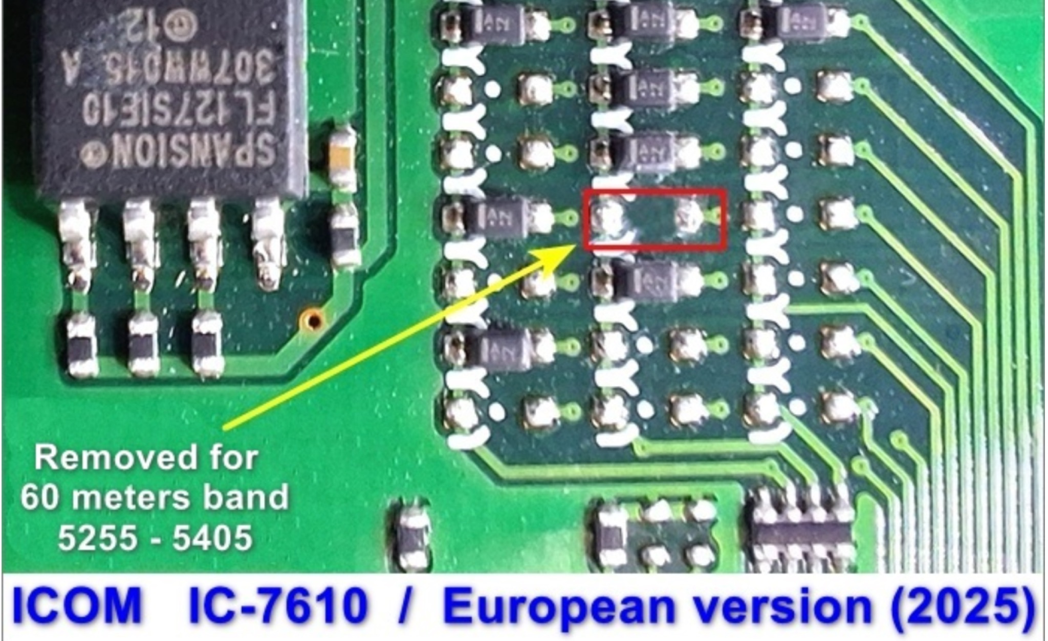 This page provides instructions for unlocking additional frequency bands on your IC-7610 transceiver to access the 60m band. The step-by-step guide is useful for hams looking to expand their operating capabilities and communicate on this popular band. By following these instructions, you can ensure that your transceiver is set up correctly to operate within the regulations of the 60m band.
 -
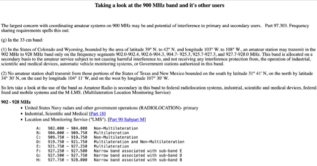 Use of the band as Amateur Radio is secondary in this band to federal radiolocation systems, industrial, scientific and medical devices, federal fixed and mobile systems and the M-LMS. Bandplans for hams. Allocation in 902 - 928 MHz
 -
 In this project by building a W2IMU feed horn, the author successfully optimized their 10GHz Small Dish EME project. To position and solder the components together, they used a jig and a conical section made of copper sheet. Stability was ensured by fitting the XLNA to the WG switch. The WG components were shod into a waterproof plastic container, and the feed horn and WG were surrounded by a collar and skirt that were 3D printed. With an average Moon noise of 0.5dB, the Sun and Moon noise readings were better than their previous configuration.
 -
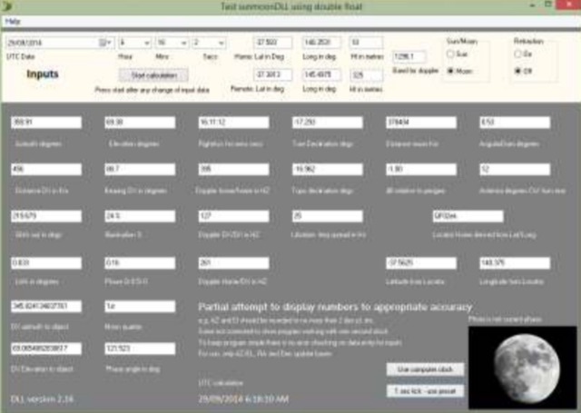 The purpose of the Moon tracking DLL is to provide an easily used platform for the calculation of the position of the sun or the moon and to provide the associated information often required for amateur radio operators interested in EME. DLL works with any of Windows versions of Delphi, Visual Basic, C and versions.
 -
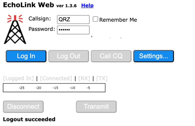 Connecting to the global *EchoLink* network via a web browser simplifies internet linking for licensed amateur radio operators. This web application provides a direct interface, eliminating the need for client software installation. Users can log in with their validated callsign and password to access the system, facilitating contacts with other stations, repeaters, and conferences worldwide, much like traditional VoIP applications but tailored for amateur radio. The interface offers essential controls for managing connections, including selecting specific stations or conferences from a dropdown list, initiating a connection, and disconnecting. Features such as a 'Call CQ' button allow users to signal their availability for a contact, while options for low bandwidth operation and accepting incoming connections optimize performance and accessibility. Audio device selection ensures proper microphone and speaker integration with the web client. Validation of an amateur radio license is a prerequisite for full access, ensuring that only authorized operators utilize the network. The system prompts unvalidated users to provide an email address and password to begin the validation process, which typically involves submitting proof of license. This free service extends the reach of amateur radio communications globally, bridging geographical distances through internet connectivity.
 -
 Approximately 100 MeshCom nodes are visualized in real-time on a geographical map, providing a dynamic overview of the LoRa mesh network. This resource, hosted by _OE1KFR_, details node positions, telemetry data, and message traffic. Users can measure distances between two selected nodes, view text messages with callsign, destination, and gateway information, and access position data including latitude, longitude, and altitude. The platform supports filtering by regions such as Europe, USA, and Asia, allowing operators to focus on specific geographical areas. The detailed node list table presents comprehensive status information for each node, including gateway callsign, firmware version, hardware type, and environmental telemetry like temperature, pressure, humidity, and CO2 levels. This granular data enables operators to monitor network health and individual node performance, facilitating troubleshooting and optimization of MeshCom deployments. The map interface enhances situational awareness for those engaged in LoRa mesh networking.
 -
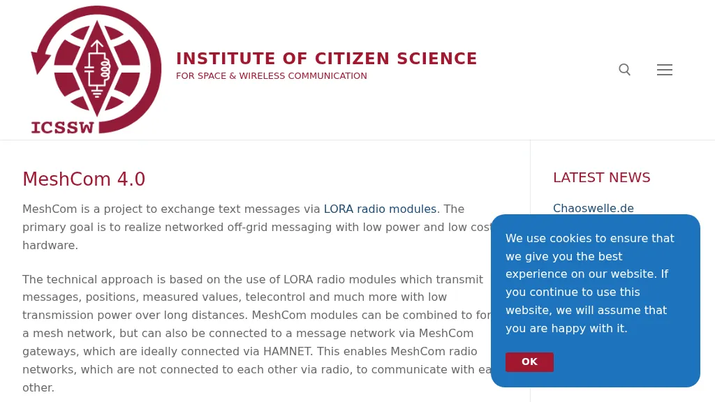 MeshCom 4.0 facilitates off-grid text messaging and data exchange via _LoRa_ radio modules, operating on low-power, low-cost hardware to establish networked communication capabilities. The system transmits messages, GPS positions, sensor values, and telecontrol data over significant distances with minimal power consumption. MeshCom modules can autonomously form a mesh network or integrate into a broader message network through MeshCom gateways, which ideally connect via _HAMNET_ to link disparate radio networks. Recent updates include MCMAP features, support for Lilygo T-Connect-Pro, and new firmware for T-ECHO, enhancing the system's versatility. The project provides basic specifications, detailed protocol information, and installation instructions for MeshCom 4.0, including guides for RAK WisBlock and HELTEC V3 hardware. Firmware and companion Android/iPhone applications are available for download, supporting a range of **10-20 km** line-of-sight communication.
 -
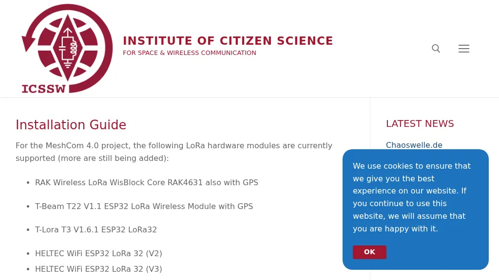 The resource provides a technical installation guide for _MeshCom 4.0_, an amateur radio mesh networking project utilizing LoRa hardware modules. It systematically covers the setup process for several supported devices, including the RAK Wireless LoRa WisBlock Core RAK4631, T-Beam T22 V1.1, T-Lora T3 V1.6.1, HELTEC WiFi ESP32 LoRa 32 (V2 and V3), HELTEC E290, ESP32 / E22 modules, and the T-deck from Lilygo. The guide specifies support for the **EU433** frequency band, ensuring amateur radio compatibility, and details the use of an online flash tool for ESP32 modules and an embedded drive for RAK modules. It further describes accessing the MeshCom 4.0 Dashboard and Map functionalities, crucial for network visualization and management. Firmware configuration for ESP32 modules is meticulously outlined, covering essential parameters such as setting callsigns, country codes, and gateway parameters via a serial console like PuTTY. Commands for activating gateway mode, setting internet IP addresses, and configuring WLAN SSID and password for modules with WLAN capability are provided, enabling modules to function as either clients or gateways within the MeshCom network.
 -
 For amateur radio operators seeking resilient, off-grid communication, the _MeshCom_ firmware provides a robust solution for text-based messaging over a mesh network. Utilizing LoRa modulation and the APRS protocol, this firmware is designed for low-energy consumption and cost-effective hardware, primarily operating in the 70cm band. Nodes, identified by amateur radio callsigns, can send short text messages to all participants or directly to specific callsigns, functioning as repeaters to extend network reach. The system supports automatic status and position messages, with optional sensor data for WX-Data and Telemetry. MeshCom nodes can be configured as gateways to HAMNET or the internet, enhancing connectivity options. The project emphasizes a self-building and self-healing mesh network architecture, crucial for emergency communication scenarios. Operating frequencies include 433.175 MHz (EU, USA, Africa), 439.9125 MHz (UK), and 433.925 MHz (Norway). The firmware is compatible with hardware platforms such as ESP32/LoRa modules, RAK-WISBLOCK, and ESP32-DEV4/E22-LoRa, offering a flexible deployment for various amateur radio applications.
 -
 The Meshtastic documentation outlines critical LoRa configuration parameters for node operation, emphasizing regulatory compliance. It details settings such as Region, Modem Preset, Max Hops, Transmit Power, Bandwidth, Spread Factor, Coding Rate, and Frequency Offset. A comprehensive table provides region codes, frequency ranges (e.g., US **902.0 - 928.0 MHz**), duty cycles, and power limits (e.g., EU_433 **12 dBm**) for numerous countries, including the US, EU, China, and Japan, alongside a 2.4 GHz band option. It explicitly states that devices within a mesh must share identical _Region_ and _Modem Preset_ settings for full communication. Modem Presets, like _LONG_FAST_ (the default), optimize for either speed or range, directly impacting network congestion and message delivery delay. For instance, SHORT_TURBO offers the fastest speed and shortest range, while VERY_LONG_SLOW provides the longest range but is less reliable for mesh formation. The document also highlights specific duty cycle limitations, such as the 10% hourly limit for EU_433 and EU_868 regions, and provides command-line interface (CLI) examples for configuring these parameters.