Search results
Query: location
Links: 215 | Categories: 14
Categories
- DX Resources > Beacons > 10 GHz Beacons
- DX Resources > DX Peditions > 2012 DXpeditions
- DX Resources > DX Peditions > 2015 DXpeditions
- DX Resources > DX Peditions > 2018 DXpeditions
- DX Resources > DX Peditions > 2019 DXpeditions
- DX Resources > DX Peditions > 2020 DXpeditions
- DX Resources > DX Peditions > 2021 DXpeditions
- DX Resources > DX Peditions > 2023 DXpeditions
- DX Resources > DX Peditions > 2025 DXpeditions
- Technical Reference > Radio Direction Finding
- Radio Scanning
- Operating Aids > Radio Spectrum
- Operating Modes > Remote Operations
- Ham Radio > Resources
-
 The Dilawri Cardiovascular Institute (DCI) is a prominent Canadian organization dedicated to advancing cardiovascular health through cutting-edge research, equitable patient care, and medical innovation. It integrates 16 core centers, including specialized units like the Centre for AI, Data Science, and Imaging, and the Centre for Heart Rhythm, to bridge research findings directly into clinical practice. Their mission emphasizes providing world-class cardiac care accessible to all patients, regardless of their geographic location, by employing disruptive innovation and creative strategies to reach individuals faster. The institute focuses on a team-based approach, ensuring patients receive the correct therapy at the optimal time for long-term well-being. DCI's commitment extends to continuous growth through education, pushing boundaries beyond standard care, and fostering a respectful, inclusive environment for both staff and patients. They lead industry collaborations to shape the detection, treatment, and management of heart disease.
 -
 Currently operate 3 repeater locations in Dix Hills, Huntington and Smithtown on 2 Meters, 1.25 Meters & 70 Centimeters.
 -
 The 160-meter amateur radio band, spanning 1.8 to 2 MHz, was historically the lowest frequency amateur allocation until the introduction of the 630-meter and 2200-meter bands. ITU Region 1 allocates 1.81–2 MHz, while other regions use 1.8–2 MHz. This band, often called "Top Band" or "Gentleman's Band," was established by the International Radiotelegraph Conference in Washington, D.C., on October 4, 1927, with an initial allocation of 1.715–2 MHz. Effective operation on 160 meters presents significant challenges due to the large antenna sizes required; a quarter-wavelength monopole is over 130 feet, and horizontal dipoles need similar heights. Propagation is typically local during the day, but long-distance contacts are common at night, especially around sunrise and sunset, and during solar minimums. The band experienced a resurgence after the LORAN-A system was phased out in North America in December 1980, leading to the removal of power restrictions.
 -
 A study on 20m antennas by Kenny Silverman, K2KW
 -
 The LU2EE Radio Club Tandil maintains a minimal web presence, primarily serving as a directory listing under the `qsl.net` domain. The resource itself offers no direct content, instead presenting an "Index of /l/lu2ee" page with a link to the "Parent Directory." This structure suggests a placeholder or an outdated web address rather than an active information hub, providing only the club's callsign and location. Without specific content, the resource does not offer technical details, operational results, or practical applications. It functions solely as a basic identifier for the _LU2EE_ club in _Tandil_, Argentina, without further elaboration on activities, membership, or technical contributions to the amateur radio community.
 -
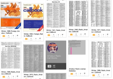 Indexes over 100 digitized amateur radio callbooks, primarily from the early to mid-20th century, providing a historical record of callsign assignments and licensee data. The collection facilitates research into past amateur radio operations, tracing callsign lineage, and identifying operators from specific eras. Each entry typically includes the callsign, licensee name, and geographic location as published in the original printed volumes. Users can browse the collection by publication date or utilize the search function to locate specific callsigns or names within the archived documents. The resource serves as a valuable repository for historical amateur radio data, supporting genealogical and operational research. Access to these scanned documents is provided directly through the Internet Archive platform, ensuring long-term preservation and availability of these historical amateur radio records.
 -
 The CES Wireless Technologies website details a range of **GPS fleet tracking** solutions designed for mobile information systems. It highlights offerings such as dispatch and mapping software, Automatic Vehicle Location (AVL) systems, and mobile data display terminals. The platform also mentions support for Automatic Number Identification (ANI) and Continuous Tone-Coded Squelch System (CTCSS) functionalities, indicating integration with two-way radio communication protocols. Specific products include GPS tracking devices and associated software for fleet management, emphasizing features like real-time location monitoring and operational efficiency. The site positions itself as a manufacturer in this specialized domain, catering to commercial and public safety sectors requiring robust mobile data solutions. While the page title mentions "Ham Radio Directory" categories, the content primarily focuses on commercial GPS and fleet management technologies, not amateur radio applications. The listed products are geared towards professional mobile radio (PMR) environments rather than typical ham radio operations.
 -
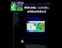 This program combines the formerly know programs PreFind and MU-Locator into one but with many improvements to find the location of any prefix, country or Maidenhead locator! Display and find locators on any map and calculate the distance and direction between two locators.
 -
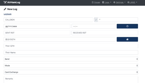 Facilitates logging of amateur radio contacts directly within a web browser, enabling seamless operation across various devices including Windows, macOS, Linux, iOS, and Android. This web-based application stores all log data securely in the cloud, providing accessibility from any internet-connected location. It supports importing existing log data via CSV files, with future plans for _ADIF_ file import, and offers a robust QSL card generation feature, producing print-ready PDF files in standard 148mm x 100mm dimensions. The platform integrates with Japanese government databases to automatically populate callsign-related information such as station location and license issue dates, streamlining data entry. It also assists with JCC/JCG searches for accurate QTH logging. The service leverages SSL encryption for all communications and benefits from security oversight by certified information security professionals. Users can register using email/password or existing Facebook/Google accounts, and the beta version is currently available for free. The system has processed over **5,297,881** logs, with **28,369** logs recorded in the past 24 hours.
 -
 The Guernsey Amateur Radio Society (GARS) provides a central hub for amateur radio operators in the Bailiwick of Guernsey, offering resources like a local _GU Callbook_ and specific notes tailored for visiting operators. The society maintains an active presence, holding regular meetings on Friday evenings from 7:30 to 9:00 PM in a unique World War II bunker located within the grounds of the Beau Sejour Leisure Centre. Beyond in-person gatherings, GARS facilitates on-air activity with a 2-meter net operating on 145.525 MHz every Tuesday night at 8:00 PM. Additionally, a DMR net is hosted on Thursday nights at 8:00 PM via the _GB7GY_ repeater, catering to digital mode enthusiasts. These nets provide opportunities for local members and visitors to connect and exchange information. Phil Cooper, GU0SUP, serves as a key contact for the society, managing inquiries and web content. The club's location is precisely described as being down a concrete staircase to the left of the road when approaching the Concourse entrance, making it straightforward for newcomers to find their way to the club's distinctive meeting place.
 -
 KC0DMH's **amateur radio homepage** provides a personal insight into the station and activities of Jonathan and Sara Imberi. The resource details the relocation of their online presence from QSL.net to a privately funded server, citing increasing site size and traffic volume as the primary reasons for the move. This transition indicates a commitment to maintaining a robust online presence for their ham radio endeavors. The site's move to **ham-shack.com** reflects a common progression for popular amateur radio personal pages, where growth necessitates dedicated hosting beyond free services. The call for donations suggests an effort to sustain the operational costs associated with a private server, ensuring continued availability of their content. This evolution highlights the dynamic nature of personal ham radio web presences and the community support often involved.
 -
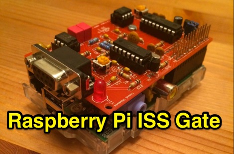 This project is an APRS iGate for digipeater aboard the ISS. As the ISS pass over the iGate location, the TNC decoded the audio tones and creates data packets the Raspberry Pi can receive.
 -
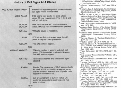 QST article from May 1994 about history of call signs from the very beginning to present system. Article explains call sign allocations, call areas, prefixes for novices and prefixes like K WA WB WD, callsigns during and after the world war II and other curiosities on US Call signs.
 -
 Which is better a 20m antenna for an island DXpedition: Yagi at 25', or a vertical or two on the beach?
 -
 Antenna Authority Inc. offers a wide assortment of directional, wideband antennas and other equipment specifically engineered for radio direction finding (DFing) and geolocation applications. Their product line includes _log periodic_, _cavity-backed spirals_, and _Yagi_ antennas, alongside covert antenna solutions for various operational requirements. The company emphasizes its expertise in designing and manufacturing specialized antennas for both overt and covert operations. Beyond standard offerings, Antenna Authority Inc. provides custom design services to meet specific client needs, focusing on tailored RF directional products. Their capabilities extend to developing antennas for vehicles and optimizing their operational performance in diverse scenarios. The firm is located at 3381 W. County Line Road, Douglasville, Ga. 30135-1145. Ferrel Bentley is associated with Antenna Authority Inc., which has been operating since at least 2005, as indicated by the copyright notice.
 -
 On March 27, 2017, the FCC adopted final rules for the USA 630-meter band, detailed in Report and Order FCC 17-33, which required PLC coordination with the Utilities Telecom Council before amateur operations could commence. This resource documents the WD2XSH experimental group's activities, including authorized stations, band plans, and frequency assignments within the 465-515 KHz range, with many stations operating between 495-499 KHz and 501-510 KHz. The site also highlights the WRC-12 decision on February 14, 2012, which granted a new **7-kilohertz-wide** secondary allocation between _472-479 kHz_ for the Amateur Radio Service worldwide. The group's efforts included operating with a maximum ERP of **20 Watts** across 45 stations in the continental USA, Alaska, and Hawaii, using emission modes such as CW, PSK-31, FSK-31, and MSK-31. The site provides links to download FCC 17-33 in PDF and DOCx formats, and offers a station location map, a list of stations by callsign and frequency, and an archive of news updates. Reception reports for any 600-meter station are encouraged to help the amateur radio community understand propagation and repeatability on this challenging band.
 -
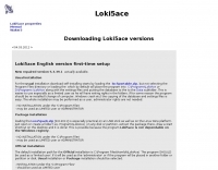 Loki5ace version 5.3.39.1 is a freeware amateur radio logging program designed for Windows operating systems (XP, Vista, 7) and compatible with Linux Wine. The software offers multiple installation methods, including a portable version (loc5portable.zip or Loce5pack.zip) that does not require administrator rights or Windows Registry modifications, making it suitable for USB stick deployment or limited user accounts. An official installation (loc5acest.zip) is also available, typically installing to C:\Program Files\Hamlok\LokiAce\ and requiring administrator privileges for initial setup and updates, with user-specific settings and database files stored in application data folders. The program's database, Loc4ac.mdb, can be renamed to the user's callsign for personalization. Loki5ace supports context-sensitive help, which requires WinHlp32.exe installation on Windows Vista and 7. The software includes features such as special print functions, Telnet Watch with comment display, and an 'Own QTH' field for location management. Updates can be performed via an in-program function or by manually copying the Loki5ace.zip file, which contains the main executable, Loki5ace.exe, to the program folder. The latest version 5.3.39.0 includes repairs for special prints and enhancements to the Telnet Watch feature.
 -
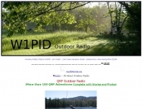 This resource documents numerous QRP (low power) portable amateur radio operations conducted by W1PID, Jim Cluett, primarily from various outdoor locations in New Hampshire. The content includes detailed accounts, photographs, and operational specifics for over 350 individual "QRP Adventures," often involving hiking, biking, or kayaking to remote sites. Each entry typically highlights the location, date, bands and modes used (frequently CW on HF), and notable DX contacts made with minimal power, sometimes as low as 200mW WSPR. The site serves as a chronicle of practical QRP field operation, demonstrating successful DXing and contesting from challenging environments. It showcases diverse operating scenarios, from mountaintops like Cannon Mountain and Knox Mountain to lakeshores, riverbanks, and even marine mobile operations. The documented contacts span numerous DXCC entities across Europe, Asia, and the Americas, providing empirical evidence of QRP's efficacy in varied propagation conditions and terrains. Specific events like the Worked All Germany contest, 13 Colonies Event, and CWT sprints are also featured.
 -
 Display your current Maidenhead locator with 10 digit precision. It also computes bearing and distance to a set of target locations using locator or latitude / longitude. Useful to align antennas in VHF / UHF / microwave DX activities. No network or fancy maps usage, so it can be used even in remote locations.
 -
 The Mississippi QSO Party, sponsored by the Mississippi Section of the ARRL, offers a prime opportunity for hams worldwide to make contact with Mississippi stations. This annual event encourages both in-state and out-of-state operators to activate Mississippi counties, promoting activity across the Magnolia State's diverse geographic regions. Participants often operate from various locations, including parks and historical sites, contributing to the unique character of the contacts. Operators typically utilize a mix of HF and VHF bands, employing CW, SSB, and digital modes to maximize their QSO count and multiplier acquisition. The exchange usually involves a signal report and county for Mississippi stations, or state/province/country for others. Results are compiled and published, recognizing top scorers in various categories and encouraging friendly competition among participants. The event serves as a significant annual gathering point for the Mississippi amateur radio community, fostering camaraderie and operational skill development.
 -
 Presents the Bullitt Amateur Radio Society (BARS), KY4KY, detailing its organizational structure, meeting schedule, and operational activities. The resource outlines regular club meetings held on the second Tuesday of each month at Pioneer Village City Hall, providing specific dates for upcoming gatherings in March and April 2026. It also highlights the weekly BARS 2-Meter Net operating on 146.70 MHz, noting its suspension on meeting nights, and provides information on the club's participation in W1AW/4 operations for Kentucky, including specific UTC time slots for March 2026 and a contact for coordination. Details for becoming a member, contributing to the repeater fund, and joining the email list are available through quick links. The resource also offers practical information for prospective hams, such as exam test locations and BARS dues. It includes directions to the meeting location at Becknell Hall (Pioneer Village City Hall) from I-265 and Preston Highway, specifying the address as 4700 Summitt Drive, and mentions the club's presence on Facebook for activity updates.
 -
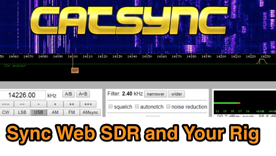 CATSync V1.30 integrates OpenWebRX support, expanding its capability to synchronize a local amateur radio transceiver's CAT control with a broader range of public WebSDR receivers. The software facilitates real-time frequency tracking, allowing the operator to adjust their physical rig's VFO and observe the connected WebSDR instantly follow the tuned frequency. This functionality is crucial for remote listening, signal comparison, and verifying propagation conditions across different geographic locations using a familiar hardware interface. The application supports both the classical WebSDR interface and KiwiSDR platforms, providing a consistent control experience across various online SDR deployments. It bridges the gap between local station operation and the vast network of globally distributed software-defined radios, offering a practical tool for DXers and contesters. CATSync is designed for Windows and Linux environments, with Android compatibility noted, making it accessible to a wide user base seeking to leverage WebSDR resources with their existing station setup.
 -
 GoGreenSolar provides comprehensive solutions for **DIY solar panel systems**, catering to both homeowners and professionals seeking energy independence or reduced utility costs. Their offerings include a variety of solar kits such as Grid-Tie, Off-Grid, and Battery Backup configurations, designed to integrate seamlessly with existing utility infrastructure or provide complete autonomy in remote locations. Customers can select from Microinverter or String Inverter kits, along with essential components like **solar panels**, inverters, batteries, and racking systems, all curated from reputable brands known for efficiency and durability. The company emphasizes end-to-end support, from initial consultation and custom system design to providing easy-to-follow installation manuals. They offer financing options, including quick-approval loans with zero down payment, and a money-back guarantee if a solar permit is not approved. The platform also features a solar calculator and a questionnaire to help users determine the most suitable system for their specific energy requirements and property characteristics. GoGreenSolar aims to simplify the solar adoption process, enabling significant savings on energy bills and labor costs. Their approach focuses on empowering users to install their own systems with expert guidance, ensuring optimal performance and a secure energy future for homes and businesses.
 -
 DX Maps provides a specialized map printing service, focusing on amateur radio applications such as world prefix maps and custom great circle projections. The platform allows radio operators to visualize propagation paths and DX entities relevant to their QTH and operational goals. This service supports the creation of high-quality, large-format maps tailored for shack display or operational planning. The service facilitates the generation of personalized maps, which can include specific callsign locations, beam headings, and other critical amateur radio data points. Users can specify parameters to create maps that aid in understanding global propagation conditions and optimizing antenna aiming for long-distance contacts. The UK-based operation ensures a localized service for European hams, with international shipping options available. DX Maps also offers QSL card printing, complementing its mapping services.
 -
 The Milwaukee Repeater Club is the oldest continuously operating repeater in Milwaukee
 -
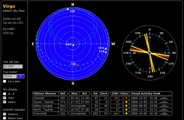 Virgo is originally designed to serve for meteorscatter propagation purposes in amateur radio. Maintained by Bastian, DB1BM, and Alexander, DL8AAU. Virgo is a projection of the sky visible at your location. Different to other astronomical sky views, there are no stars displayed, but the radiants of current meteor showers.
 -
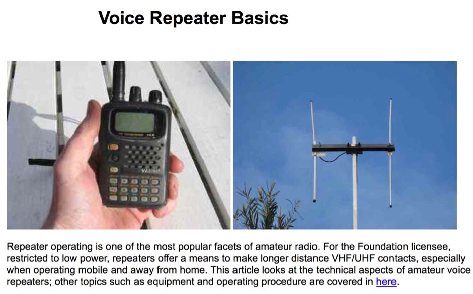 Sixty-meter repeaters typically use a 1 MHz frequency separation between input and output, while 2-meter repeaters commonly employ a **600 kHz** split and 70-centimeter repeaters use a **5 MHz** offset. This article details the fundamental technical principles of amateur voice repeaters, explaining how they extend VHF/UHF communication range by receiving on one frequency and simultaneously retransmitting on another. It covers essential components such as receivers, transmitters, filters, and antennas, often situated on elevated locations for optimal coverage. The resource delves into the critical challenge of _desensing_—where the repeater's strong transmit signal overpowers its own receiver—and the engineering solutions employed, including antenna separation and the use of high-Q cavity filters. It also explores various control and timing systems, from basic squelch activation to more sophisticated microcontroller-based boards that manage functions like voice identification, time-out timers, and fault protection. Different access methods are discussed, including open access, toneburst, CTCSS subtone, and DTMF, each offering distinct advantages for managing repeater usage and mitigating interference. Furthermore, the article examines repeater linking, both conventional RF methods and modern internet-based solutions, highlighting how linking expands coverage and promotes activity across multiple repeaters or bands. It introduces less common repeater types such as 'parrot' repeaters, which use a single frequency and digital voice recording, and linear translators, capable of relaying multiple signals and modes simultaneously across different bands, often found in amateur satellites.
 -
 The Eastman Amateur Radio Club (VE4TG) operates a **VHF repeater** at 146.73 MHz and a **UHF repeater** at 444.15 MHz, both located at the Manitoba Hydro gas-fired generating station near Selkirk. These repeaters are situated on the power plant roof, leveraging its infrastructure for antenna placement. The club's primary objective is to offer a reliable local repeater site for members in the East Selkirk and Lockport areas, ensuring consistent amateur radio access. Beyond routine communication, the club maintains a standby communications link to assist local municipal authorities during emergencies requiring communications support. The unique repeater site location at a generating station provides a robust backup power supply, enhancing reliability. The club also organizes activities such as a weekly net and participates in WARC Field Day, fostering community engagement and operational readiness.
 -
 Approximately 524,475 Brazilian amateur radio operators are cataloged within this resource, offering a comprehensive database for the South American region. Each entry includes geographical coordinates, enabling users to visualize station locations directly within Google Earth. This functionality supports DXers in identifying potential contacts and understanding propagation paths relative to specific Brazilian QTHs. The platform serves as a digital callbook, primarily focused on the Brazilian amateur radio community. It facilitates the lookup of callsigns and associated location data, which is crucial for award tracking, contest planning, and general operational awareness. The integration with mapping services provides a visual dimension to traditional callsign databases, enhancing the utility for operators interested in geographical aspects of radio communication.
 -
 The interactive Smith chart enables users to navigate their way around a Smith chart, using simple discrete element impedance matching. This page allows users to try using the Smith chart, for education and interest purposes, without installing any software. Try changing the value in the load box to see the location of the impedance on the chart.
 -
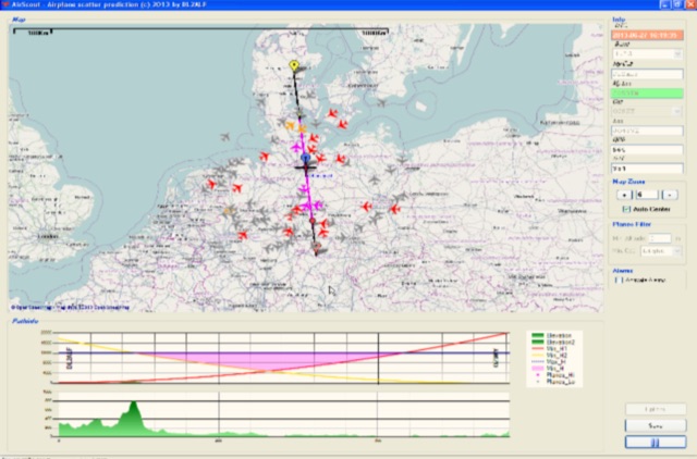 Software for Aircraft Scatter Prediction. Extend your capabilities on VHF-/UHF-SHF bands even when you live in an unprivileged location and Calculate a propagation path between two stations and follow the aircrafts in real time
 -
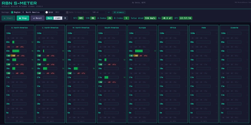 The RBN S-Meter visualizes real-time HF propagation data from the Reverse Beacon Network (RBN). It processes thousands of automated spots per hour, providing a real-time picture of active RF paths on HF bands. Users can set their vantage point using _Region Mode_ or _Grid Square Mode_. Region Mode allows selection from broad geographic areas like E. North America or Europe, while Grid Square Mode uses a Maidenhead grid square and radius for more precise data. The app displays eight region panels, each with horizontal bars for bands 160m through 6m, indicating signal strength with a color ramp from green to red. A dimmer trail shows peak hold values, and an S-unit readout provides additional detail. The app is a free web application accessible on any device, offering a practical tool for ham radio operators interested in CW, RTTY, and FT8 signals. It features a Progressive Web App installation option for enhanced usability on mobile and desktop platforms. Users can install it on Android, iOS, and Windows devices, providing a native app-like experience. The app replaces the previous Windows standalone executable, incorporating user feedback to improve features like grid square mode and automatic location detection.
 -
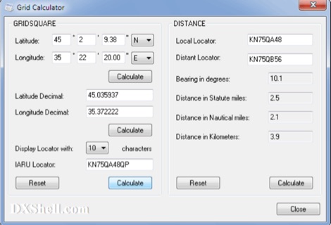 Grid Calculator allows you to calculate either a grid square locator or the latitude and longitude of a location. Grid Calculator can be used to calculate a Great Circle bearing and distance between two stations in statute miles, nautical miles, and kilometers.
 -
 The EA8ALP personal page, hosted on QSL.net, is currently inaccessible, presenting a 404 "Page Cannot Be Found" error. This resource was intended to feature Adelto, an amateur radio operator from the Canary Islands, likely detailing his station, operating activities, or other personal ham radio interests. The QSL.net platform, which hosts over 30,000 amateur radio websites, provides free web and email services to operators and organizations, relying on donations for support. While the specific content of EA8ALP's page is unavailable, the platform's structure suggests it would typically include information relevant to **DXing** and **contesting**, common interests for operators in geographically desirable locations like the Canary Islands. Users encountering this error are advised to contact the website owner directly or use an internet search to locate the intended content, as QSL.net cannot assist with individual site content issues.
 -
 Presented is a historical collection of short-wave listening (SWL) QSL cards, primarily from the late 1930s and early 1940s, offering a glimpse into early international broadcasting and the technical pursuits of SWL operators like Les Miles during that era. The resource showcases specific QSLs from stations such as _Broadcasting Corporation of Japan_, _XGOY - The Central Broadcasting Administration_ in Chungking, China, and _Australian broadcasting ship, Kanimbla VK9MI_, each with reception dates and frequencies like 11.90MHz or 9.525MHz. It highlights the self-sufficiency of SWL enthusiasts who constructed and maintained their own radio and test equipment, evoking the sensory experience of vintage valve receivers. The collection provides concrete examples of international broadcast stations active before and during World War II, including _2RO3 - Rome_ and _WRUL - World Wide Broadcasting Foundation_ from Boston. Each QSL entry details the station, location, reception date, and often the frequency, such as 9.63MHz or 11.26MHz, allowing for historical verification of broadcast schedules. The resource also briefly mentions the operational details of the _VK9MI_ offshore radio station, directing readers to further information on its history. This compilation serves as a tangible record of global radio communication during a pivotal historical period.
 -
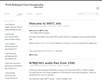 The World Radiosport Team Championship (WRTC) is a unique on-site ham radio competition, typically held every four years, bringing together top operators globally. Unlike traditional contests where participants operate from their home QTH, WRTC competitors travel to a designated location and operate from identical stations under field conditions, ensuring a level playing field. Past events have taken place in diverse locations such as Seattle (1990), Slovenia (2000), Russia (2010), and Italy (2023), showcasing the international scope of this **radiosport** challenge. Because each WRTC event is organized by a dedicated, volunteer-driven committee, historical information and results often become dispersed across various online platforms. This resource serves as a centralized repository, diligently collecting and preserving data from all previous WRTC competitions. It provides a consistent point of reference for participants, enthusiasts, and researchers interested in the history and evolution of this premier **DX contesting** event. The WRTC Sanctioning Committee officially endorses this site, ensuring its accuracy and completeness.
 -
 The ZS1J/B beacon operates on 28.2025 MHz with 5 Watts output to a half-wave, end-fed vertical antenna, initially installed in 1977 as ZS5VHF near Durban. The 10-meter transmitter is a modified 23-channel CB radio, and the identification keyer uses a diode matrix unit with TTL ICs from the same era. After relocation to Plettenberg Bay in 1993, the beacon has been in continuous service, with additional QRP transmitters later installed for other bands. In 1994, a single-transistor, 80-meter, 0.5-watt QRP transmitter with a half-wave dipole was added on 3586 kHz, followed by a 160-meter, 0.5-watt unit on 1817 kHz. A 30-meter, 0.5-watt transmitter was installed in 1996, operating on 10.124 MHz. In 2002, a 40-meter QRRP beacon on 7029 kHz, with an output of 100 microwatts, achieved DX reports up to 1100 km from ZS6UT in Pretoria. Best DX reports for the 80m and 160m beacons came from 9J2BO.
 -
 Demonstrates the online presence of the West Island Amateur Radio Club (WIARC), a Canadian amateur radio organization. The resource presents fundamental club information, including contact details via an "info" email address. It also indicates the club's location within Quebec, Canada, and its focus on **ham radio** activities. The site's technical implementation notes its creation with **Arachnophilia 4.0**, a specific HTML editor. This resource, while minimal in content, serves as a digital point of contact for the WIARC. It confirms the club's existence and provides a channel for inquiries, which is typical for many local amateur radio clubs. The mention of a frame-compliant browser suggests an older web design, common for sites maintained over several years.
 -
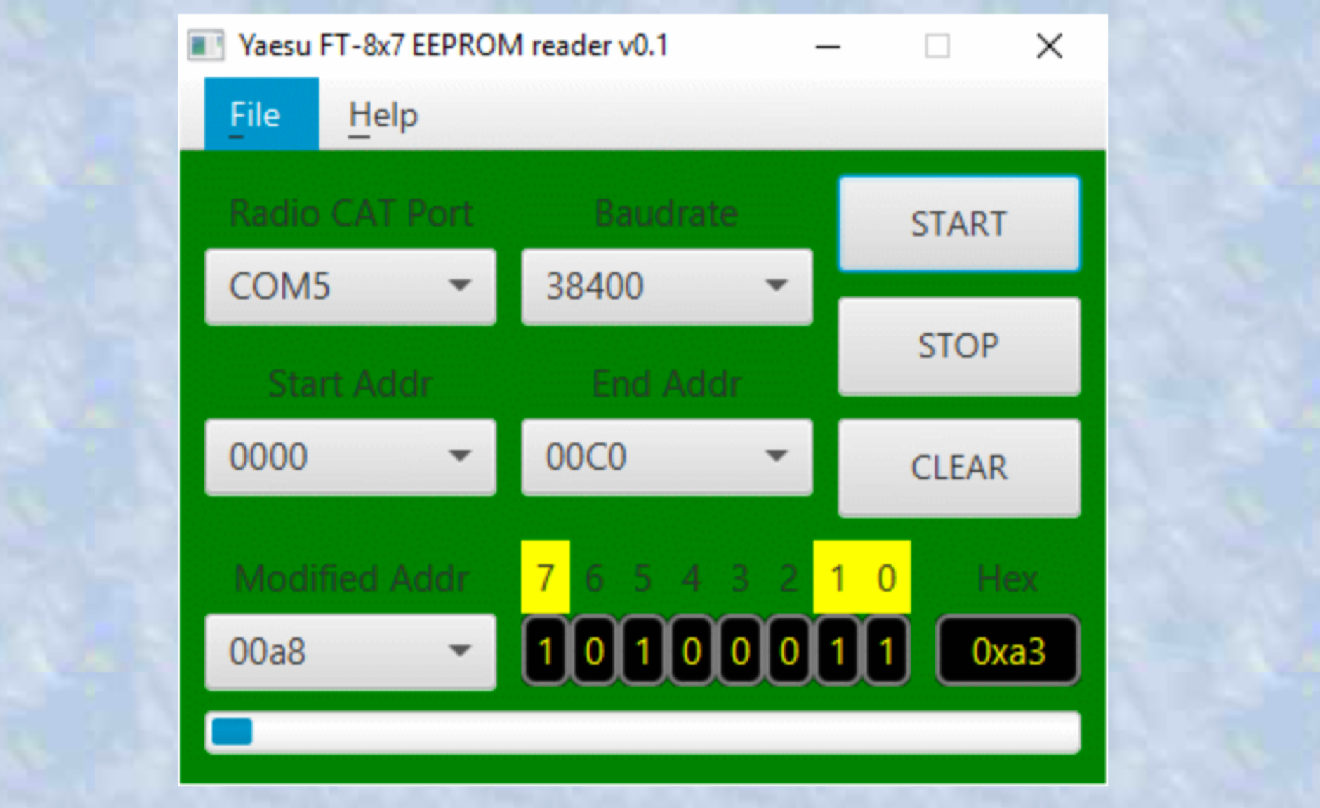 A Java multiplatform application used to find EEPROM locations for different radio settings. a very simple to use multi-platform Java application which can be used to find EEPROM locations for different transceiver settings. This information can then be used to send the right CAT commands to configure the radio remotely. Use this application on your own risk.
 -
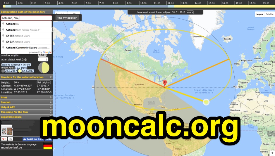 Mooncalc shows the motion of the Moon and Moon phase for a particular day at a particular location. You can see the moon positions for moon rising, selected time and Moonset.
 -
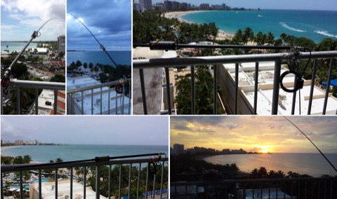 The Buddistick antenna, as demonstrated by KP4MD, effectively handles up to **250 watts** and provides coverage from 40 through 10 meters, with an optional coil extending operation to 80 and 60 meters. KP4MD's video presentation meticulously describes the antenna setup, emphasizing the critical role of the _shunting coil_ for achieving resonance on lower bands like 40 and 80 meters. This practical approach highlights how a compact antenna can deliver solid performance from a constrained location. SWR curve diagrams are included, clearly illustrating the impact of the shunting coil on the antenna's resonating frequency. These visual aids provide concrete evidence of the adjustments needed for optimal operation across different bands, particularly when space is at a premium. KP4MD's insights are particularly valuable for hams operating from apartments or other limited spaces, showcasing real-world results from a balcony installation.
 -
 Amateur Packet Reporting System (APRS) operations often require compact, reliable solutions for transmitting position data, particularly for mobile or portable stations. This resource details the construction of the _Tiny Track-I_, a transmit-only APRS tracker designed for straightforward integration with a VHF radio and a Global Positioning System (GPS) receiver. It enables hams to broadcast their location without the complexity of a full-duplex TNC. The project outlines the printed circuit board (PCB) layout and schematic, based on an original design by N6BG, with a personal PCB drawing by SV1BSX. It includes specific component placement and notes an additional 10uF/10V capacitor (C5) for improved IC voltage decoupling, a modification not present in the original N6BG diagram. The unit connects to a computer or GPS via a DB9 female connector. This tracker is ideal for basic position reporting, offering a simple and effective way to participate in APRS networks. Its small footprint makes it suitable for vehicle installations or field deployments where space is limited, providing a **reliable 9600 baud** data stream for location updates.
 -
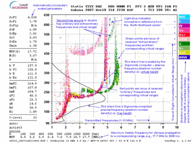 This page displays the current ionogram and tries to determine the nearest digisonde report to your location. Data coming from this sondes are used to determine the MUF for oblique propagation on HF spectrum
 -
 Appendix 42 to the Radio Regulations, published by the International Telecommunication Union (ITU), serves as the authoritative global reference for assigning call sign series to countries. This essential resource allows radio operators, including those in the amateur service, to accurately identify the national origin of a station based on its callsign prefix. It is fundamental for DXers, contesters, and anyone involved in international two-way radio communication, ensuring correct country identification for awards like _DXCC_. The table details the specific blocks of call signs allocated to each administration, facilitating the unambiguous determination of a station's geographical location. For instance, prefixes like K, W, N, and AA-AL are assigned to the United States, while G and M series denote the United Kingdom. Understanding these allocations is crucial for logging contacts and verifying QSLs. This ITU publication is regularly updated to reflect changes in national assignments and new allocations, maintaining its accuracy as the definitive source for call sign series worldwide. It underpins the global framework of radio communication.
 -
 The New England Digital Emergency Communications Network is dedicated to providing reliable amateur radio communications throughout New England. The group members have built an advanced TDMA network connecting strategic locations and communicators
 -
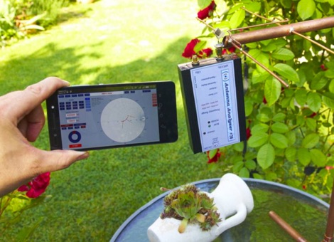 Antenna Analyzer plus 500 is a multifunctional measuring instrument, very useful for amateur radio activity. Its size allows you to easily take it for relocation as well. Frequency range: 100KHz - 500MHz. Access directly via WiFi. Includes a dual-channel signal generator
 -

-
 The BikeLoop antenna project details the construction of a double magnetic loop antenna optimized for VLF frequencies, specifically around 136 kHz. This innovative design incorporates two orthogonal loops, which significantly enhance reception capabilities. Key construction hints include utilizing lightweight bicycle rims for the antenna structure, making it easy to transport and set up in various locations. The document provides valuable mathematical and electrical insights into the antenna's performance, alongside practical reception tests conducted in the Italian Alps, showcasing its effectiveness in capturing various VLF signals, including Sferics and FSK transmissions. Proper setup is crucial for optimal performance. The project emphasizes the importance of grounding and avoiding interference from nearby electrical sources. The reception tests revealed the antenna's ability to capture a range of signals, demonstrating its practical application for enthusiasts interested in VLF reception and antenna experimentation. Overall, the BikeLoop serves as an excellent starting point for those looking to explore the world of VLF frequencies and enhance their antenna-building skills.
 -
 The "DIY Telescopic-V Antenna £35" project showcases the creation of a budget-friendly, portable telescopic V-shaped antenna inspired by commercial designs. Using eBay-sourced telescopic whips and custom mounting solutions, the author documents their process, testing, and adaptations. Despite challenges like weather and missing tools, the antenna performed well across multiple bands, enabling successful QSOs. Future improvements include exploring loading coils and testing in better locations. The compact design offers versatility for amateur radio enthusiasts seeking an affordable and practical solution.
 -
 Operating under the callsigns G1ORC, G4ORC, and M5ORC, the Oldham Amateur Radio Club (OARC) serves as a local hub for radio enthusiasts in Royton, Oldham, England. This RSGB-affiliated organization welcomes individuals with an interest in any facet of radio communication, fostering a community environment for learning and on-air activity. The club maintains an active calendar, detailing upcoming amateur radio events and specific courses hosted by OARC, providing a structured approach to engagement for its members. Club activities are centered at the No.1855 (Royton) Squadron Air Training Corps on Park Lane, a consistent meeting point for members. This physical location facilitates hands-on learning, equipment demonstrations, and social interaction among hams. OARC's commitment to the hobby is evident through its multiple transmitting licenses, enabling diverse operational experiences for its members across various bands and modes.