Search results
Query: location
Links: 215 | Categories: 14
Categories
- DX Resources > Beacons > 10 GHz Beacons
- DX Resources > DX Peditions > 2012 DXpeditions
- DX Resources > DX Peditions > 2015 DXpeditions
- DX Resources > DX Peditions > 2018 DXpeditions
- DX Resources > DX Peditions > 2019 DXpeditions
- DX Resources > DX Peditions > 2020 DXpeditions
- DX Resources > DX Peditions > 2021 DXpeditions
- DX Resources > DX Peditions > 2023 DXpeditions
- DX Resources > DX Peditions > 2025 DXpeditions
- Technical Reference > Radio Direction Finding
- Radio Scanning
- Operating Aids > Radio Spectrum
- Operating Modes > Remote Operations
- Ham Radio > Resources
-
 Amateur Television (ATV) is a ham radio technology that transmits and receives broadcast-quality video and audio. It utilizes existing standards for commercial television and can be used for various purposes including experimentation, entertainment, and public service events. ATV signals can be relayed over long distances using repeaters and are capable of transmitting live video from locations like the International Space Station. The article explores how to get started with ATV, highlighting its ease of use and suitability for beginners in ham radio. The future of ATV appears promising with advancements in digital and narrowband transmission techniques.
 -
 DK4MJ's blog details numerous POTA activations and outdoor amateur radio operations, predominantly from Germany. The content focuses on practical experiences in the field, often involving portable setups and antenna deployments for various bands. Articles frequently describe specific station configurations, power sources, and operational challenges encountered during activations. Many entries include photographs of the operating environment and equipment, such as _portable antennas_ and transceivers, providing visual context to the operational narratives. The blog serves as a personal log of amateur radio adventures, sharing insights into effective portable operating techniques and station optimization for remote locations. Regular updates cover recent activations and related amateur radio topics.
 -
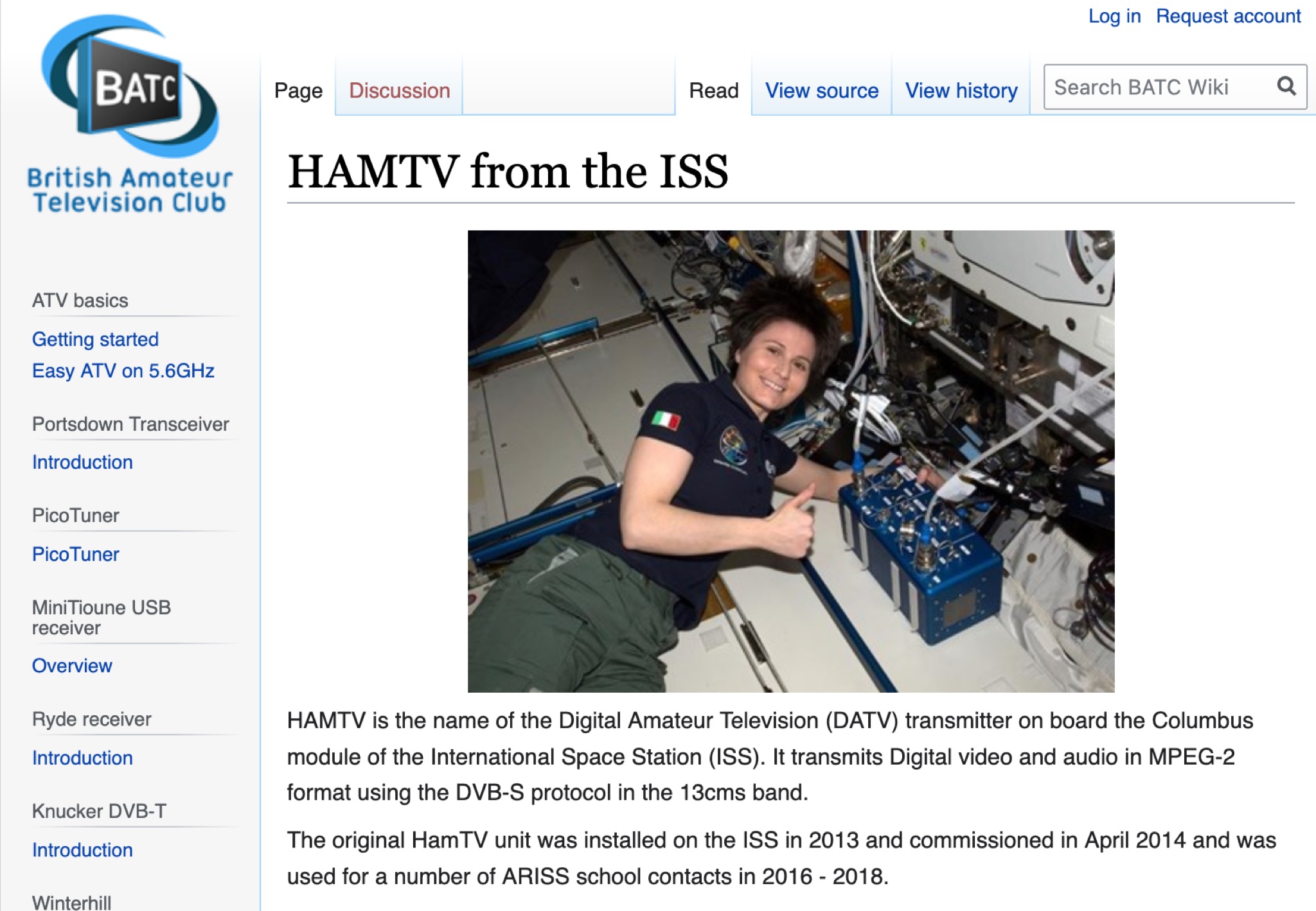 Learn about the HAMTV Digital Amateur Television (DATV) transmitter on the International Space Station (ISS), transmitting video and audio in MPEG-2 format using the DVB-S protocol. Discover its history, installations, failures, and repairs, as well as the current status and live video feed. Explore the technical details and challenges of the HAMTV transmitter, including power output, polarization, and antenna location. Find recordings of previous transmissions and understand the potential signal reflections caused by various ISS components. Stay updated on the latest developments and activities related to HAMTV from the ISS.
 -
 Documents the operational planning for the **XX9W** DXpedition to Macao, a **DXCC** entity. This resource outlines the team composition, identifying 14 operators from various IARU regions, including EA1CJ, F2JD, and JH4RHF. It details the expedition's objective to activate Macao, officially the Macao Special Administrative Region of the People's Republic of China, emphasizing its distinct blend of Portuguese and Chinese cultures, historic architecture, and urban landscape. The site also provides information on how to support the DXpedition through donations, facilitating contributions via PayPal. Macao operates under the "one country, two systems" principle, with Chinese (Cantonese) and Portuguese as official languages, and a population exceeding 680,000. The content highlights the region's geographical location on the southern coast of China, across the Pearl River Delta from Hong Kong, and its historical background as a Portuguese colony.
 -
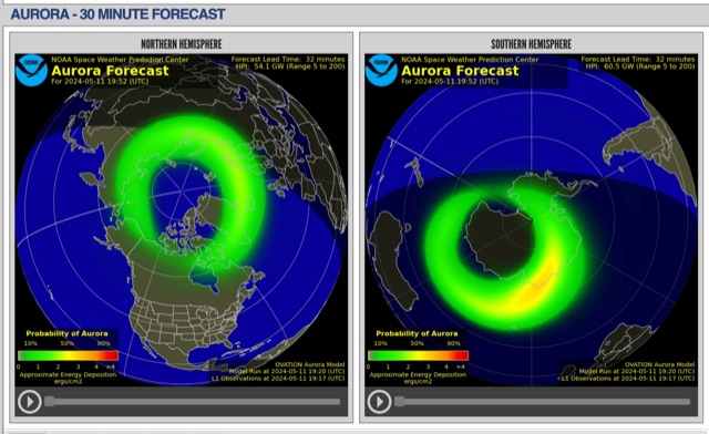 The short-term aurora forecast, based on the OVATION model, predicts aurora location and intensity 30 to 90 minutes ahead, aligning with solar wind travel time. Maps show aurora ovals in green, turning red for higher intensity. Aurora, visible after sunset or before sunrise, impacts technologies like radio communication, GPS, and power grids. It's a mesmerizing space weather spectacle, drawing travelers to the Arctic.
 -
 Over 200 distinct 2-meter band amateur radio repeaters are cataloged for Australia, providing essential operational data for VHF communication. Each entry specifies the repeater's output frequency, often including the input tone (e.g., **91.5 Hz** or **123.0 Hz** CTCSS) and the repeater's callsign (e.g., _VK2RSC_, _VK3RHF_). Locations are precisely noted, frequently referencing specific towns, mountains, or geographical features such as "Kinglake, Kangaroo Ground" or "Adaminaby, Mars Hill." The resource also indicates various digital modes and linking capabilities where applicable, such as "FMEchoLinkFusionWIRES-X" or "DMR," alongside standard FM operation. This detailed listing facilitates local and regional VHF communication, enabling hams to program their transceivers accurately for repeater access. The data is presented in a clear, tabular format, making it straightforward to identify repeaters by frequency and location.
 -
 This page presents a project involving attaching an amateur radio transceiver to an Arduino to create a 'fox' signal for radio direction finding practice. This project can be used to practice direction finding skills by locating a radio transmitter in a hidden location. The project involves transmitting the station ID using Morse code and can be a fun and educational activity for students or hobbyists interested in radio direction finding. The author shares their experience with radio direction finding and provides instructions on how to build the project using a Baofeng UV-3R radio and an Arduino Uno.
 -
 Callook provides a **USA amateur radio callsign lookup service** with data current as of March 25, 2026. The platform allows users to search for valid callsigns and retrieve detailed information, including geographic coordinates sourced from the Bing Maps API. A mathematically calculated **grid square** is derived from these coordinates, though accuracy is not guaranteed due to reliance on external services. The service supports multiple access methods, including a browser search plugin, direct API access with a reference, and plain text output for integration into other applications or scripts. This tool facilitates rapid identification of US amateur radio operators, offering an alternative to other callbook services. Its API access enables developers to integrate callsign lookup functionality into custom applications, streamlining data retrieval for logging software or contest management. The direct presentation of FCC data, combined with grid square calculation, assists DXers and contesters in verifying contact information and location details during on-air operations.
 -
 The HD8G DXpedition will take place in the stunning Galapagos Islands from April 18 to April 26, 2025. This operation will involve 26 dedicated amateur radio operators activating the islands, which are designated as IOTA SA-004. The team aims to make a significant number of contacts, providing an exciting opportunity for DXers and enthusiasts to work this unique location. With a rich history and diverse wildlife, the Galapagos Islands offer a picturesque backdrop for this event. Participants can expect to engage in various modes of operation, including SSB and CW, as the team works to log as many QSOs as possible. The DXpedition is anticipated to generate a high volume of activity, with operators from multiple countries contributing to the effort. This is a prime opportunity for those looking to add a rare entity to their DXCC list or simply enjoy the thrill of working a special event from a remote location.
 -
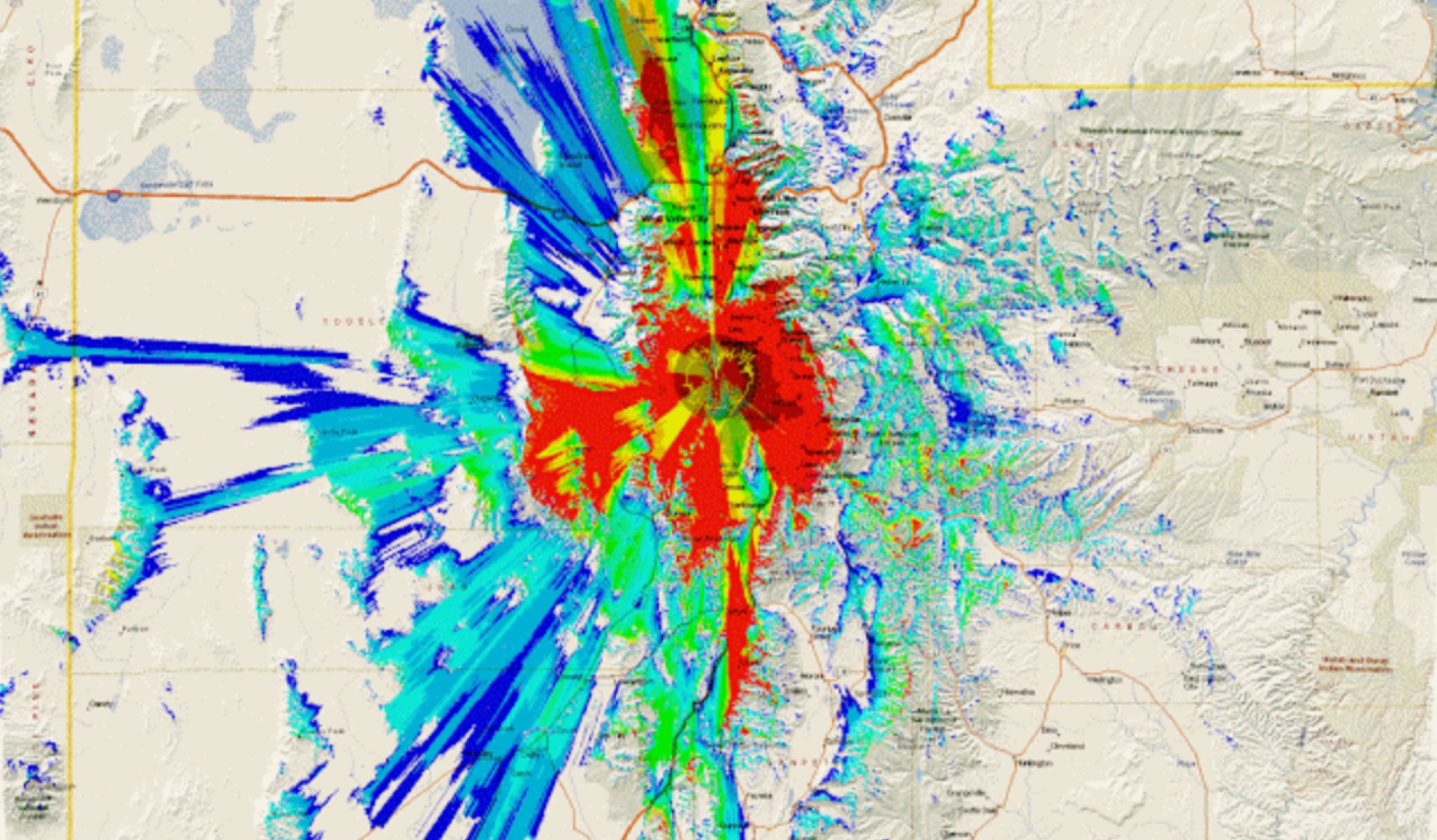 This study analyzes the antenna pattern of the Utah Amateur Radio Club's 146.760 MHz repeater following antenna relocation in 1997. Noting degraded transmission toward the north, a customized signal mapping system using a Yaesu FT-817, GPS, and software was developed to log real-time signal data. Calibration techniques extended the radio's signal range, enabling precise field measurements. The method allowed continuous signal strength monitoring while driving, revealing anomalies in coverage likely due to tower modifications. Findings helped assess and visualize the antenna’s actual radiation pattern and highlighted environmental impact on signal distribution.
 -
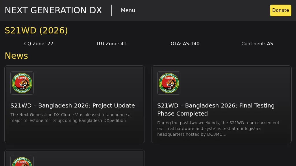 Presents the S21WD DXpedition to Bangladesh (IOTA **AS-140**) scheduled for 2026, organized by the Next Generation DX Club e.V. It outlines the project's progress, including final hardware and systems testing, and the team's successful arrival and activation from the target location. The resource provides a concise summary of Bangladesh, covering its geography, cultural aspects, and economic landscape. The page includes the Clublog Most Wanted ranking for Bangladesh, categorized by continent and mode, as of January 2026. The DXpedition aims to achieve over 70,000 QSOs across CW, SSB, RTTY, and FT8 modes, with a specific focus on RTTY (targeting over 2,000 QSOs) and **lowband** operations. The team plans a Multi-Single entry in the ARRL CW 2026 contest. QSO data will be uploaded to Clublog and LoTW, with Clublog livestream and daily free LoTW uploads anticipated, contingent on stable internet connectivity. The S21WD callsign corresponds to CQ Zone 22 and ITU Zone 41. Further details include a preliminary bandplan, FT8 operating guidelines using MSHV software, a VOACAP DX Prediction link, and an azimuthal map centered on Bangladesh. QSL services are managed by DJ4MX via Clublog OQRS, offering direct, bureau, and LoTW options, with daily LoTW uploads expected.
 -
 This presentation explores the practice of QRP (low-power) amateur radio operation in outdoor settings. It guides operators to identify their specific objectives for portable operations, which inform equipment and antenna choices. The discussion covers considerations including portability, operating modes, power requirements, and weather resistance. Various antenna designs are examined, from vertical configurations to dipoles and end-fed options, with emphasis on deployment practicality in public spaces. The presentation concludes with practical advice on selecting operating locations, RF safety, and resources for equipment and community support for QRP enthusiasts.
 -
 Over 44,000 square kilometers of Scotland's natural beauty provide a unique backdrop for the _GMFF_ award program. Designed for amateur radio operators who thrive on portable operations, this program encourages activators to set up stations in designated flora and fauna areas. Participants engage in _SSB_ and _CW_ modes, making contacts from these scenic locations, which are part of the _WorldWide Flora and Fauna_ network. Activators and chasers alike benefit from the program's structure, which awards points for successful contacts. The _GMFF_ program is part of a larger global initiative, allowing operators to contribute to conservation awareness while enjoying their hobby. With a focus on environmental preservation, the program aligns amateur radio activities with ecological interests, promoting responsible and sustainable operating practices. The program's website provides resources for participants, including maps of designated areas and guidelines for operation. By participating, operators not only enjoy the challenge of portable operation but also support the conservation of natural habitats. The _GMFF_ program thus combines the thrill of amateur radio with a commitment to environmental stewardship.
 -
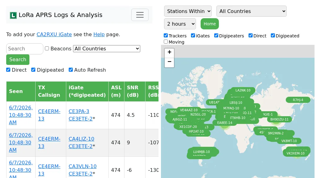 Demonstrates the operational status and reach of the LoRa APRS infrastructure, providing a live mapping and logging service for network participants. Users can verify network coverage, monitor _iGates_, and track mobile stations, observing messages and real-time network activity. The platform offers insights into station locations and data flow within the LoRa APRS system, which is crucial for understanding the performance of LoRa technology in Automatic Packet Reporting System applications. This utility helps amateur radio operators understand where transmissions are being received and processed by iGates, and how mobile units are moving within the network. The site's analysis tools provide RF performance monitoring and metrics, enabling users to assess network efficiency and identify areas for improvement. For example, operators can see how many packets are received by specific iGates, or track the path of a mobile station over a **100 km** range, offering practical insights into signal propagation and network reliability for _packet radio_ enthusiasts.
 -
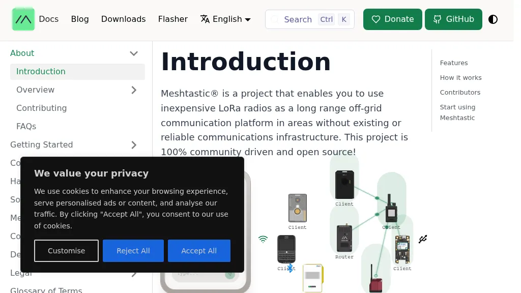 Meshtastic utilizes _LoRa_ radio protocol for long-range, off-grid communication, functioning as a decentralized mesh network. The system allows users to send and receive text messages without reliance on existing infrastructure or a phone for mesh communication, leveraging inexpensive LoRa radios. Key features include encrypted communication, excellent battery life, and optional GPS-based location services, with radios designed to rebroadcast messages to ensure all group members receive them. The project has achieved a record range of **331km** and is 100% community-driven and open source, with its codebase available on GitHub. Unlike traditional ham radio, Meshtastic operates on LoRa, which is generally accessible without additional licenses. Each Meshtastic radio can be paired with one phone at a time for message exchange, and support is entirely volunteer-based.