Search results
Query: call sign regions
Links: 9 | Categories: 2
-
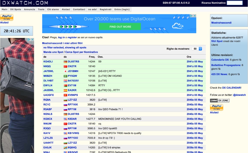 DX clusters aggregate real-time amateur radio spot data, enabling operators to identify active stations and propagation conditions across various bands and modes. DXWatch offers a web-based interface for this essential operating tool, allowing users to filter spots based on specific criteria such as band, mode, or callsign. The service integrates features like a customizable filter system and an external widget for embedding spot data on other platforms, enhancing its utility for DXers and contesters. Operators can access worldwide spot data, with options to zoom into specific regions like the US, Europe, or the North Atlantic, facilitating targeted DXing efforts. The platform also includes a watchlist feature for registered users, enabling personalized tracking of desired stations or entities. Real-time data on solar flux index (SFI), A-index, and K-index are displayed, providing crucial propagation insights alongside the DX spots.
 -
 Understanding high-frequency (HF) skywave propagation is crucial for amateur radio operators seeking to optimize long-distance communications. This resource details the fundamental principles of HF radio propagation, including the properties of electromagnetic waves, the characteristics of various HF bands, and distinct propagation modes such as skywave, ground wave, and line-of-sight. It places significant emphasis on the ionosphere's pivotal role in refracting HF waves, explaining how solar activity directly influences ionospheric conditions and, consequently, propagation paths. The resource integrates real-time monitoring capabilities, featuring dynamic charts and data from DX clusters, WSPRnet, and the Reverse Beacon Network, which allow users to track current band activity and propagation conditions globally. It also delves into advanced topics like Near Vertical Incidence Skywave (NVIS) and gray line propagation, providing insights into ionosonde data and various propagation prediction models. The site presents a detailed analysis of solar-terrestrial interactions, geomagnetic indices, and space weather phenomena, illustrating their direct impact on HF communication reliability. Practical tools and applications are highlighted, including real-time QSO planners, online Maximum Usable Frequency (MUF) maps, and alerts for solar flares or geomagnetic storms. The guide systematically breaks down complex concepts into accessible chapters, offering a structured approach to learning about ionospheric regions, diurnal and seasonal effects, and the interpretation of propagation indicators like foF2, MUF, and Lowest Usable Frequency (LUF). This makes it a robust reference for hams aiming to deepen their technical understanding and improve operational effectiveness.
 -
 Presents a detailed compilation of **6-meter** voice repeaters operating within the 53-54 MHz segment across Australia (VK) and New Zealand (ZL), providing essential data for local and visiting radio amateurs. Each entry specifies the repeater's output and input frequencies, its assigned callsign (where applicable), the primary service area, current operational status (e.g., operational, under construction, scrapped), and a **Maidenhead grid locator**. The resource also includes the date the repeater was last heard or updated, offering insights into its recent activity. This listing is meticulously maintained by VK2KFJ, who updates entries based on personal observations and confirmed reports from other operators. It serves as a practical reference for hams seeking to utilize the 6-meter band for local communication via repeaters, particularly for those engaged in mobile or portable operations within the specified regions. The data helps operators configure their transceivers correctly for accessing these vital communication hubs. Beyond the repeater details, the page also notes common 6-meter FM voice simplex frequencies, such as the 52.525 MHz international call frequency, and lists historical packet simplex frequencies, though their current operational status is uncertain. This comprehensive approach ensures that operators have a broad overview of 6-meter activity in VK and ZL.
 -
 The 160-meter amateur radio band, spanning 1.8 to 2 MHz, was historically the lowest frequency amateur allocation until the introduction of the 630-meter and 2200-meter bands. ITU Region 1 allocates 1.81–2 MHz, while other regions use 1.8–2 MHz. This band, often called "Top Band" or "Gentleman's Band," was established by the International Radiotelegraph Conference in Washington, D.C., on October 4, 1927, with an initial allocation of 1.715–2 MHz. Effective operation on 160 meters presents significant challenges due to the large antenna sizes required; a quarter-wavelength monopole is over 130 feet, and horizontal dipoles need similar heights. Propagation is typically local during the day, but long-distance contacts are common at night, especially around sunrise and sunset, and during solar minimums. The band experienced a resurgence after the LORAN-A system was phased out in North America in December 1980, leading to the removal of power restrictions.
 -
 The Mississippi QSO Party, sponsored by the Mississippi Section of the ARRL, offers a prime opportunity for hams worldwide to make contact with Mississippi stations. This annual event encourages both in-state and out-of-state operators to activate Mississippi counties, promoting activity across the Magnolia State's diverse geographic regions. Participants often operate from various locations, including parks and historical sites, contributing to the unique character of the contacts. Operators typically utilize a mix of HF and VHF bands, employing CW, SSB, and digital modes to maximize their QSO count and multiplier acquisition. The exchange usually involves a signal report and county for Mississippi stations, or state/province/country for others. Results are compiled and published, recognizing top scorers in various categories and encouraging friendly competition among participants. The event serves as a significant annual gathering point for the Mississippi amateur radio community, fostering camaraderie and operational skill development.
 -
 Low-frequency (LF) radio time signals, operating primarily in the 40–80 kHz range, are broadcast by national physics laboratories for precise clock synchronization. Transmitters like **JJY** (40 kHz, 50 kW; 60 kHz, 50 kW), RTZ (50 kHz, 10 kW ERP), MSF (60 kHz, 15 kW ERP), WWVB (60 kHz, 50 kW ERP), RBU (66.66 kHz, 10 kW), and DCF77 (77.5 kHz, 50 kW) cover vast geographic areas, often several hundred to thousands of kilometers. LF signals offer distinct propagation advantages over higher-band transmissions such as GPS. Their long wavelengths (3–6 km) enable effective diffraction around obstacles like mountains and buildings. The ionosphere and ground act as a waveguide, eliminating the need for line-of-sight and allowing a single powerful station to cover extensive regions. Ground wave propagation minimizes ionospheric variability effects on transmission delay, and signals penetrate most building walls effectively. Robust and low-cost receivers, often priced at 20–30 USD/EUR, are widely used in radio clocks. These receivers typically comprise a tuned ferrite core antenna, a receiver IC (e.g., Atmel T4227, U4223B, MAS1016) for amplification and AM detection, and a microcontroller for decoding the time signal and phase-locking a local clock. Specific components for DCF77, MSF, and WWVB are readily available from vendors like HKW Elektronik and Ultralink.
 -
 Documents the XR0ZR DXpedition to Juan Fernandez Island (SA-005) in November 2013, providing insights into activating a highly sought-after DXCC entity. The team's efforts focused on maximizing QSO opportunities across various bands and modes, a critical aspect for stations aiming to complete their DXCC or IOTA awards. Operating from a remote location like Juan Fernandez presents unique logistical and technical challenges, which the expedition successfully navigated to put this entity on the air for thousands of eager DXers worldwide. The resource outlines the operational period, the callsign XR0ZR, and the specific island group activated. Such DXpeditions are vital for the global amateur radio community, enabling hams in less accessible regions to achieve their award goals and fostering international communication. The detailed account serves as a historical record of a significant activation.
 -
 Approximately 100 MeshCom nodes are visualized in real-time on a geographical map, providing a dynamic overview of the LoRa mesh network. This resource, hosted by _OE1KFR_, details node positions, telemetry data, and message traffic. Users can measure distances between two selected nodes, view text messages with callsign, destination, and gateway information, and access position data including latitude, longitude, and altitude. The platform supports filtering by regions such as Europe, USA, and Asia, allowing operators to focus on specific geographical areas. The detailed node list table presents comprehensive status information for each node, including gateway callsign, firmware version, hardware type, and environmental telemetry like temperature, pressure, humidity, and CO2 levels. This granular data enables operators to monitor network health and individual node performance, facilitating troubleshooting and optimization of MeshCom deployments. The map interface enhances situational awareness for those engaged in LoRa mesh networking.
 -
 NCPACKET is a club whose mission is to create a social media network in North Carolina and adjoining counties and whose network is Internet free, and based on TARPN technology. The NCPACKET project was started in 2014 and the NCPACKET group was started in 2019. NCPACKET meets at restaurants throughout the networked regions. See the website for maps and callsigns of people who could help you get started in the project.