Search results
Query: google earth propagation
Links: 3 | Categories: 0
-
 Approximately 524,475 Brazilian amateur radio operators are cataloged within this resource, offering a comprehensive database for the South American region. Each entry includes geographical coordinates, enabling users to visualize station locations directly within Google Earth. This functionality supports DXers in identifying potential contacts and understanding propagation paths relative to specific Brazilian QTHs. The platform serves as a digital callbook, primarily focused on the Brazilian amateur radio community. It facilitates the lookup of callsigns and associated location data, which is crucial for award tracking, contest planning, and general operational awareness. The integration with mapping services provides a visual dimension to traditional callsign databases, enhancing the utility for operators interested in geographical aspects of radio communication.
 -
 Analyzes the operational dynamics of the _IARU R1 VHF contest_, the world's largest 2-meter contest, focusing on factors enabling top performers to maintain consistent results amidst declining overall activity. The resource investigates the physical constraints that limit higher point totals, examining how technical capabilities, increased interference, and evolving station setups contribute to contest outcomes. It provides insights into the strategic and technical aspects of achieving high scores, such as the **1,000,000+ point** totals observed from leading stations. Compares the performance of various stations over time, highlighting the sustained success of top contenders and speculating on future trends in VHF contesting. The analysis delves into specific operational strategies and equipment choices that differentiate high-scoring stations, offering a detailed look at the competitive landscape. It also considers the impact of propagation conditions and operator skill on final scores, providing a comprehensive overview of the contest's intricate mechanics and the pursuit of maximum QSO points.
 -
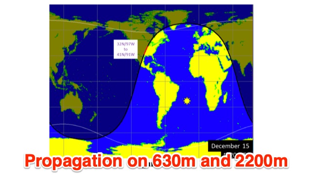 This is a theoretical look at propagation on 630-Meters and 2200-Meters using ray tracing software. It expands on the brief discussion in the ARRL Handbooks. The Earth's magnetic field affects 630-Meter and 2200-Meter band propagation. Lower ionization reduces absorption, aiding low-frequency propagation. Differences exist between bands, limited daytime sky-wave propagation. Sunrise/sunset show promise, yet mechanisms are unclear. Ducting possible at night in specific conditions. Negative ions enhance propagation. Inefficient antennas and high man-made noise are anticipated. Groundwave propagation is significant on 2200-Meters.