Search results
Query: satellite tracking syste
Links: 9 | Categories: 0
-
 A rugged motorized satellite antenna tracking system for construction by the home handyman
 -
 Orbitron, a cardware application, provides robust satellite tracking capabilities for radio amateurs and visual observers alike. It leverages NORAD SGP4/SDP4 prediction models to accurately display satellite positions in real-time or simulation, accommodating up to 20,000 objects loaded from _TLE files_. The software includes an advanced search engine for satellite passes and _Iridium flares_, offering printable results for planning observations or QSO attempts. Sebastian Stoff's creation supports various visualization options, including a 'Nightlife' dark color scheme for nocturnal use, and integrates a database of cities and satellite frequencies. Users can synchronize their PC clock via NTP and update TLE data over HTTP, with ZIP support. The application also features rotor and radio control capabilities, either built-in or through user-defined drivers, which is particularly useful for automating antenna pointing during satellite passes. Its interface is designed for ease of use, making satellite tracking accessible even for beginners. First released in 2005, Orbitron 3.71 runs on Windows 9x/Me/2k/XP/2k3/Vista and can operate on Linux via _Wine emulation_, requiring minimal system resources. The software's precision relies on periodic TLE updates, especially for low-Earth orbit objects, to account for orbital decay and maneuvers by satellites like the ISS or Soyuz.
 -
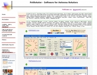 PstRotator handles just about every controllable rotator in common use: Prosistel, Green Heron, HyGain, RC1 MDS, Rotor-EZ Idiom Press, Yaesu Az and many more PstRotator includes automatic tracking for satellite or EME communications, using programs like WSJT, VQLog, TACLog, Z-Track, GJTracker, EME System, Trak_SM, WXtrack, WinOrbit, Orbitron, Nova for Windows, Sat_Explorer, SatPC32, Win-Test. PstRotator supports remote control over TCP/IP.
 -
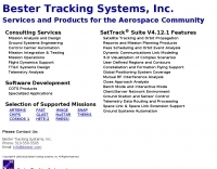 Satellite Tracking and Orbit Propagation, Reports and Mission Planning Products, Pass Scheduling and Orbit Event Analysis, Dynamic Communications Link Modeling, 3-D Visualization of Complex Scenarios User Defined Regions and Contours, Constellation and Formation Flying Support, Global Positioning System Coverage
 -
 Satellite Tracking/Orbital Prediction Program an open-source, multi-user satellite tracking and orbital prediction program written under the Linux operating system by John A. Magliacane, KD2BD. PREDICT is free software
 -
 Live realtime satellite tracking system show current status of amateur radio satellites, ISS tracking is also provided by showing ISS Visible Passes based on your own location. This web site show the International space station live position and can be used as an iss tracker app to determine future satellite and ISS transit over your location.
 -
 The 10-minute, 25-second video demonstrates making a QSO via the VO-52 amateur radio satellite, focusing on real-time Doppler shift correction. It features Simon, 2E0HTS, operating a Yaesu FT-847 transceiver and a homebrew dual-band Yagi antenna, specifically a 10-element 435 MHz Yagi for uplink and an IO Loop for 145 MHz downlink. The video visually details the operator's technique for continuously adjusting the uplink frequency to compensate for the satellite's changing velocity relative to the ground station, a critical aspect of successful satellite communication. The demonstration highlights the practical application of Doppler compensation, showing the operator tuning the transmit frequency to maintain a stable received signal from the satellite. This approach contrasts with systems employing automatic Doppler correction or full-duplex operation, providing insight into manual frequency management for satellite passes. The video serves as a direct, observational guide for hams interested in LEO satellite operations, particularly those using non-tracking, manually tuned setups.
 -
 This resource provides a detailed historical record of satellite downlink frequencies, systematically organized by both frequency range and the satellite's launch year. It presents extensive listings covering segments from 8 MHz to 9000 MHz, including specific breakdowns like 136-137 MHz and 1600-2200 MHz. The data is segmented into distinct frequency blocks, offering granular information for various bands. The content delineates frequencies for satellites launched across several decades, with specific sections for years such as 2004, 1999, and extending back to 1967. This chronological organization allows for tracking the evolution of satellite communication frequencies over time. The resource serves as a reference for identifying operational downlink frequencies of historical space assets, which is particularly useful for satellite enthusiasts and those interested in _space tracking_ or _vintage satellite_ communications. The utility of this compilation lies in its specific historical data, providing a unique perspective on past satellite operations and frequency allocations.
 -
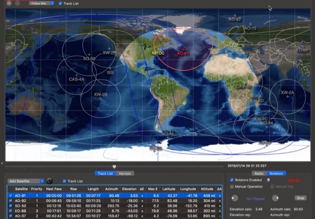 This article provides a step-by-step guide for assembling a Raspberry Pi-based Satellite Tracker Interface, designed to work with Green Heron Engineering's RT-21 controllers and MacDoppler software. The guide covers hardware assembly, SD card image installation, and system configuration for satellite tracking.