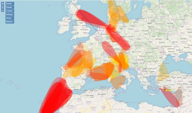
VHF – Based on realtime APRS reports. This map shows real-time radio propagation from stations operated near 144 MHz. It uses data gathered by Automatic Packet Reporting System-Internet Service (APRS-IS) from packet stations in the amateur radio service.
The map shows activity from the past hour. Paths are smoothed to create a color-coded footprint indicating the distance VHF signals are likely to be traveling.
By APRS Hits: 260 | Votes: 0 | Rating: 0.00
About VHF APRS Propagation Map
The resource is currently on dxzone.com in 2 categories. Main category is
Radiowave propagation resources that is about Radio wave propagation links for amateur radio.
This link has been on our site since Thursday Aug 18 2022, and "
VHF APRS Propagation Map" has been clicked on 260 times. So far no one has rated it yet. Be the first to rate it!
Discover more websites like this one in these categories:
Rate this resource
no one has rated it yet. Be the first to rate it!
The scale is 1 - 10, with 1 being poor and 10 being excellent.
Webmaster, add a Remote rating
Report this link
If you find this link broken, not working or inappropriate, please
Report this link to us.
Related links
Explore these additional resources we've chosen for you from the same category, as we believe they might also capture your interest.
Visit this link
|
VHF APRS Propagation Map
|
|
Share this resource
Share this link with your friends, publish within popular social networks or send it via email.
Search
About Us
The DXZone is the largest human created library of amateur radio Web sites, it currently lists more than 20,000 links organized into more than 600 categories. Since 1998, a group of radio amateurs has been reviewing new sites for listing every day and evaluating the best place to list them. The DXZone is one of the longest-running amateur radio sites still active on the Web.
Survey