Search results
Query: Frequency Planning
Links: 7 | Categories: 0
-
 Select your favorite satellite and watch its trajectory on Google Maps in real time! Includes ISS tracking, Weather, Geostationary, GPS Military, and of course Amateur radio satellites. N2YO provides comprehensive real-time satellite tracking with particular emphasis on amateur radio satellites. The service offers precise pass predictions calculated for user-specific locations, displaying upcoming passes with azimuth, elevation, and duration data essential for ham operators planning satellite contacts. N2YO features dedicated tracking for amateur radio satellites including FM, linear transponder, and digital satellites, with frequency information and downlink/uplink details. The platform delivers live tracking visualizations on interactive maps, Doppler shift calculations, and automated email notifications for upcoming passes. This free resource integrates weather satellite tracking alongside NOAA imagery, making it invaluable for radio enthusiasts pursuing satellite communications.
 -
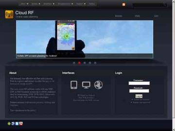 Online radio planning system, allow you to generate accurate radio frequency predictions for anywhere on earth
 -
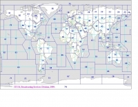 Explore this high-resolution ITU Zones Map, a critical reference resource for amateur radio operators, international broadcasters, and telecommunications engineers. Originally established by the International Telecommunication Union – Radiocommunication Sector (ITU-R) Broadcasting Services Division (1999), this chart accurately divides the globe into 90 specific CIRAF zones. This authoritative visual guide is indispensable for planning High Frequency (HF) radio propagation, scheduling international broadcasts, and verifying locations for radio contests and awards. Distinct from the 40 CQ Zones, the ITU zoning system provides the official administrative framework used for global frequency management. This digitally enhanced version ensures maximum clarity of zone boundaries and numbering (e.g., Zone 28 for Central Europe), making it an essential tool for technical accuracy in logbooks and station management. It serves as a trustworthy standard for educators, hobbyists, and industry professionals alike.
 -
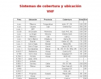 Presents a comprehensive listing of VHF and UHF repeater systems operating within Ecuador, detailing their operational frequencies and geographical coverage. The resource includes specific entries for locations such as _Guayaquil_, Cuenca, and Manta, alongside their respective frequency pairs. For instance, the Cerro Azul repeater in Guayaquil operates on **6.760- T**, indicating a transmit offset, while the Sta. Elena system utilizes a 26.660 MHz transmit frequency. The data provides essential information for local and visiting amateur radio operators seeking to utilize regional repeater infrastructure. It delineates coverage areas using two-letter provincial abbreviations, such as AZ for Azuay and GY for Guayas, facilitating route planning and mobile operation. This compilation is particularly useful for those engaged in local communications or emergency preparedness within the Ecuadorian amateur radio community, offering a practical guide to available repeater assets.
 -
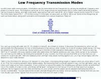 The 2200-meter band (135.7-137.8 kHz) presents unique challenges for amateur radio operators due to its narrow 2.1 kHz bandwidth, low signal levels, and high noise. W1TAG explores various transmission modes suited for this demanding environment, highlighting that traditional voice modes like SSB and AM are impractical. Plain old CW serves as the baseline, demonstrating effectiveness across different modes, though signal-to-noise ratio (SNR) significantly limits practical speeds. The article notes that reducing CW speed below 5 WPM can improve copy, especially with computer-aided spectrum analysis software capable of decoding signals too weak for human ear reception. QRSS, or "CW sent slowly enough that speeds are best expressed in seconds per dot," is a key mode for LF work, with examples ranging from 3 seconds/dot to extreme 240 seconds/dot transmissions. _Argo_ by I2PHD is mentioned as a simple program for QRSS, enabling reception of signals like BRO, a Part 15 beacon, at a distance of **1100 miles**. Other modes discussed include Dual Frequency CW (DFCW), which uses frequency shifts to distinguish dots and dashes, and Binary Phase Shift Keying (BPSK), a phase modulation technique employing 0 to 180-degree phase flips. WOLF (Weak-signal Operation on Low Frequency), a specialized BPSK form by KK7KA, encodes 15-character messages into 960-bit packages, taking 96 seconds to transmit, and has demonstrated successful reception over **672 seconds** for a message from a 1-watt beacon. Further modes include PSK, FSK variations like JASON and MSK, and graphical modes such as Hellschreiber and Chirped Hell. The article concludes with a practical chart comparing the time required to send a simple message like "WD2XES FN42CH " across these diverse LF modes, offering valuable insights for operators planning contacts on the low bands.
 -
 Operating on the HF and VHF bands, the URE WebCluster serves as a real-time DX spotting network for amateur radio operators. It aggregates DX spots from various sources, presenting them with detailed information such as DX callsign, frequency, mode, and spotter details. The platform integrates essential propagation data, including current solar indices like _K-index_ and _A-index_, alongside visual propagation maps, which are crucial for planning long-distance contacts. Users can submit new DX spots, contributing to the collective intelligence of the amateur radio community, and filter existing spots by band, mode, or callsign, enhancing operational efficiency. This resource enables operators to monitor band openings and identify active DX stations, significantly aiding in _DXCC_ pursuit and contest operations. The integration of solar-terrestrial data directly within the cluster interface allows for immediate correlation between propagation conditions and observed DX activity, a feature not universally present in all web clusters. By providing both raw spot data and contextual propagation information, the URE WebCluster offers a practical tool for real-time decision-making during operating sessions, allowing hams to quickly adapt to changing band conditions and target specific _DX_ entities.
 -
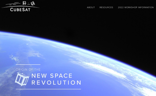 The **CubeSat** standard, developed by California Polytechnic State University (Cal Poly) and Stanford University, facilitates frequent and affordable access to space for small satellites. This resource serves as a central hub for the CubeSat community, offering a comprehensive directory of active and past CubeSat projects, technical specifications, and educational materials. It details the standardized dimensions and mass constraints for these pico-satellites, which typically range from 1U (10x10x10 cm, 1.33 kg) to 12U configurations, enabling their deployment as secondary payloads on various launch vehicles. The site also provides insights into mission planning, component selection, and regulatory considerations for amateur radio satellite operations. Operators and developers can utilize the project directory to research existing CubeSat missions, understand their communication protocols, and identify potential collaboration opportunities. The platform's forum section allows for direct engagement with other enthusiasts and experts, fostering knowledge exchange on topics such as **AMSAT** frequency coordination, telemetry decoding, and ground station setup. This collaborative environment supports the development of new CubeSat projects, promoting innovation in amateur radio satellite communication and space exploration.