Search results
Query: geographical locations
Links: 8 | Categories: 0
-
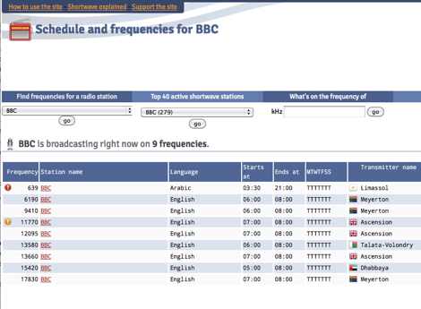 Presents a dynamic, searchable database of shortwave broadcast schedules from around the world, enabling users to locate active stations or plan listening sessions based on scheduled transmission periods and frequencies. The resource details specific station names, such as _Radio Habana Cuba_, _Deutsche Welle_, and _All India Radio_, alongside their operational times and assigned kilohertz frequencies. It also incorporates a distance calculator, which leverages geographical coordinates to estimate propagation paths, though it notes occasional data inaccuracies leading to transmitters appearing in oceanic locations. The platform's development log highlights continuous updates, including the integration of new seasonal schedules like "A24 frequencies" and "B23 schedule," reflecting the fluid nature of shortwave broadcasting. It documents challenges with geolocation services, particularly concerning Google API changes that impacted distance calculations and required user-side browser configuration adjustments for optimal functionality. The site owner, VAXXi, frequently communicates these technical adjustments and database updates, often acknowledging user contributions and donations. Distinctively, the resource provides a historical perspective through its update archives, illustrating the evolution of shortwave listening over more than a decade since its inception in 2011. It also mentions specific events, such as the BBC adding shortwave broadcasts for Ukraine on 5875 kHz and 15735 kHz, demonstrating its responsiveness to global events impacting broadcast schedules. The site's commitment to user feedback is evident in its bug reporting and feature request mechanisms, contributing to its ongoing refinement.
 -
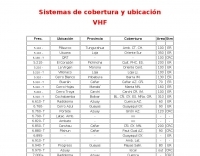 Presents a comprehensive listing of VHF and UHF repeater systems operating within Ecuador, detailing their operational frequencies and geographical coverage. The resource includes specific entries for locations such as _Guayaquil_, Cuenca, and Manta, alongside their respective frequency pairs. For instance, the Cerro Azul repeater in Guayaquil operates on **6.760- T**, indicating a transmit offset, while the Sta. Elena system utilizes a 26.660 MHz transmit frequency. The data provides essential information for local and visiting amateur radio operators seeking to utilize regional repeater infrastructure. It delineates coverage areas using two-letter provincial abbreviations, such as AZ for Azuay and GY for Guayas, facilitating route planning and mobile operation. This compilation is particularly useful for those engaged in local communications or emergency preparedness within the Ecuadorian amateur radio community, offering a practical guide to available repeater assets.
 -
 The resource provides specific information regarding amateur radio operations from various French islands, focusing on geographical and visual data. It includes photographic documentation of locations and detailed maps, which are crucial for operators planning DXpeditions or seeking to understand the unique challenges and opportunities presented by island activations. The content aims to support enthusiasts interested in rare grid squares and IOTA (Islands On The Air) awards. While currently under maintenance, the site's stated future enhancements include QSL card examples, which would offer practical insights into confirmation processes for these specific entities. The emphasis on French islands distinguishes it from more general DX resources, providing a concentrated body of information for a niche but active segment of the amateur radio community, particularly those pursuing island-specific operating awards.
 -
 The HA8TKS VHF DXCluster is an essential online resource for amateur radio operators focusing on VHF and higher frequencies. This platform provides real-time information on DX spots, allowing users to track and engage in two-way radio communications effectively. The integrated map mash-up feature enhances the user experience by visually displaying the locations of DX stations, making it easier for operators to plan their contacts and optimize their antenna setups based on geographical data. In addition to the DXCluster functionality, the site offers various HAM tools, including a QRB calculator, which helps operators determine the distance to DX stations based on Maidenhead grid locators. The platform supports multiple modes of operation, including CW, SSB, RTTY, and digital modes like FT8 and JT65. With a user-friendly interface and comprehensive data, the HA8TKS VHF DXCluster is a valuable asset for both novice and experienced operators looking to enhance their DXing and contesting activities.
 -
 Approximately 524,475 Brazilian amateur radio operators are cataloged within this resource, offering a comprehensive database for the South American region. Each entry includes geographical coordinates, enabling users to visualize station locations directly within Google Earth. This functionality supports DXers in identifying potential contacts and understanding propagation paths relative to specific Brazilian QTHs. The platform serves as a digital callbook, primarily focused on the Brazilian amateur radio community. It facilitates the lookup of callsigns and associated location data, which is crucial for award tracking, contest planning, and general operational awareness. The integration with mapping services provides a visual dimension to traditional callsign databases, enhancing the utility for operators interested in geographical aspects of radio communication.
 -
 The EA8ALP personal page, hosted on QSL.net, is currently inaccessible, presenting a 404 "Page Cannot Be Found" error. This resource was intended to feature Adelto, an amateur radio operator from the Canary Islands, likely detailing his station, operating activities, or other personal ham radio interests. The QSL.net platform, which hosts over 30,000 amateur radio websites, provides free web and email services to operators and organizations, relying on donations for support. While the specific content of EA8ALP's page is unavailable, the platform's structure suggests it would typically include information relevant to **DXing** and **contesting**, common interests for operators in geographically desirable locations like the Canary Islands. Users encountering this error are advised to contact the website owner directly or use an internet search to locate the intended content, as QSL.net cannot assist with individual site content issues.
 -
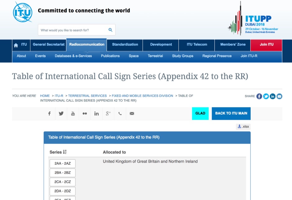 Appendix 42 to the Radio Regulations, published by the International Telecommunication Union (ITU), serves as the authoritative global reference for assigning call sign series to countries. This essential resource allows radio operators, including those in the amateur service, to accurately identify the national origin of a station based on its callsign prefix. It is fundamental for DXers, contesters, and anyone involved in international two-way radio communication, ensuring correct country identification for awards like _DXCC_. The table details the specific blocks of call signs allocated to each administration, facilitating the unambiguous determination of a station's geographical location. For instance, prefixes like K, W, N, and AA-AL are assigned to the United States, while G and M series denote the United Kingdom. Understanding these allocations is crucial for logging contacts and verifying QSLs. This ITU publication is regularly updated to reflect changes in national assignments and new allocations, maintaining its accuracy as the definitive source for call sign series worldwide. It underpins the global framework of radio communication.
 -
 Over 200 distinct 2-meter band amateur radio repeaters are cataloged for Australia, providing essential operational data for VHF communication. Each entry specifies the repeater's output frequency, often including the input tone (e.g., **91.5 Hz** or **123.0 Hz** CTCSS) and the repeater's callsign (e.g., _VK2RSC_, _VK3RHF_). Locations are precisely noted, frequently referencing specific towns, mountains, or geographical features such as "Kinglake, Kangaroo Ground" or "Adaminaby, Mars Hill." The resource also indicates various digital modes and linking capabilities where applicable, such as "FMEchoLinkFusionWIRES-X" or "DMR," alongside standard FM operation. This detailed listing facilitates local and regional VHF communication, enabling hams to program their transceivers accurately for repeater access. The data is presented in a clear, tabular format, making it straightforward to identify repeaters by frequency and location.