Search results
Query: world wide map
Links: 16 | Categories: 0
-
 Footprint Satellite Tracker is a satellite tracking software that provides real-time monitoring of satellite movements worldwide. It features a global map with celestial markers and allows users to adjust time settings to predict satellite paths. Customizable options include location coordinates and time zones. Users can analyze satellite ephemeris and print reports, though file-saving requires a virtual printer. Despite its research utility, the software supports a limited satellite list and lacks options for manual data source connections. Current version has been tested running on Windows 10.
 -
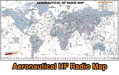 A large worldwide map of aeronautical service Frequencies allocation on HF bands dated 2002
 -
 This free PDF file contains two Worldwide grid square maps. The first map displays the fields (first two letters of a maidenhead locator) while the second includes also squares (third and fourth digit) and it can be useful to determine what is your ham radio grid square. PDF file can be enlarged and scaled to A3 and higher dimensions.
 -
-
 The image is a all in one map of ITU Zones displaying worldwide regions and zones. It provides information on ITU Regions at IARU website, aimed at radio amateurs and technical users. Image size is in hight resolution and jpeg format, free to download.
 -
-
 A live map of current KiWiSDR receivers available on the network. It allows users to explore a directory of web-controlled receivers for listening to HF and VHF stations worldwide. The site provides access to remote ham radio stations online, making it a valuable resource for amateur radio operators.
 -
 BeaconSpot.uk provides an accurate, real-time picture of microwave and VHF/UHF beacons operating across Europe, alongside a worldwide listing of 6-meter beacons. The platform allows users to retrieve detailed data for individual beacons, facilitating in-depth analysis of signal characteristics and propagation paths. Interactive maps visualize beacon distribution by frequency band and display spot coverage for each station, offering a clear geographical overview of active beacons. The system integrates real-time DXCluster spots, sourced from contributors like Alain, ON4KST, and Pascal, F5LEN, and enables users to submit outgoing spots directly to the DXCluster. Beacon keepers can manage their beacon data, receive email alerts upon being spotted, and track their station's ODX (Outstanding DX) records. For every received spot, the distance to the beacon is automatically calculated and displayed, aiding propagation studies.
 -
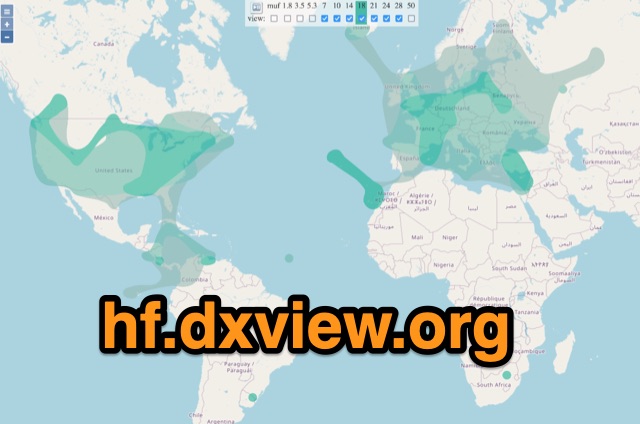 This map shows real-time radio propagation from stations operating on 11 bands between 1.8 and 54 MHz in the amateur radio service. The display shows world-wide activity from the last 15 minutes and is automatically updated about every minute. Data for the map is gathered from several online sources: WSPRnet, Reverse Beacon Network (CW, FT4, FT8), PskReporter, and DX Cluster.
 -
 On March 27, 2017, the FCC adopted final rules for the USA 630-meter band, detailed in Report and Order FCC 17-33, which required PLC coordination with the Utilities Telecom Council before amateur operations could commence. This resource documents the WD2XSH experimental group's activities, including authorized stations, band plans, and frequency assignments within the 465-515 KHz range, with many stations operating between 495-499 KHz and 501-510 KHz. The site also highlights the WRC-12 decision on February 14, 2012, which granted a new **7-kilohertz-wide** secondary allocation between _472-479 kHz_ for the Amateur Radio Service worldwide. The group's efforts included operating with a maximum ERP of **20 Watts** across 45 stations in the continental USA, Alaska, and Hawaii, using emission modes such as CW, PSK-31, FSK-31, and MSK-31. The site provides links to download FCC 17-33 in PDF and DOCx formats, and offers a station location map, a list of stations by callsign and frequency, and an archive of news updates. Reception reports for any 600-meter station are encouraged to help the amateur radio community understand propagation and repeatability on this challenging band.
 -
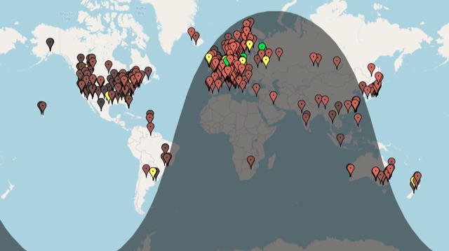
 The first interactive map of amateur radio repeaters and more updated in REAL TIME.
 -
 Participating in state QSO parties offers a focused opportunity for amateur radio operators to make contacts within a specific geographic area, often aiming to work all counties or administrative divisions. The Michigan QSO Party (MiQP) serves as an annual event where hams worldwide can connect with stations located in Michigan, contributing to county totals and overall scores. This resource provides the official rules, historical results, and information on planned operations, enabling participants to prepare effectively for the contest. Contesters can access details on scoring, exchange requirements, and various operating categories, ensuring compliance with the _Mad River Radio Club_ (MRRC) sponsored event. The site also offers downloadable Michigan county maps, a crucial tool for those pursuing county hunting awards or planning their operating strategy to maximize **multipliers**. Beyond the contest specifics, the platform facilitates community engagement through a link to the official groups.io mailing list, fostering interaction among participants and organizers. It also directs newcomers to the _ARRL_ for general amateur radio licensing information.
 -
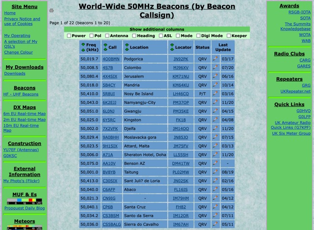 World-Wide 50MHz Beacons database maintanied by G0LGS provide a fully sortable table available also in a google map format
 -
 The Ontario QSO Party (OQP), an annual event, takes place on the third full weekend of April, specifically from 1800Z April 18 to 0300Z April 19, 2026, and 1200Z to 2000Z April 19, 2026. This **QSO party** encourages stations outside Ontario to contact as many Ontario amateur radio stations as possible, while Ontario stations work both in-province and worldwide. Key rule changes for 2026 include phone QSOs now counting equally with **CW** QSOs (2 points), the introduction of VE3RHQ as a bonus station, a 250m county line proximity definition, and a new Fixed County Line Category, alongside an adjustment of contest times. Established in 1998 by Bob Chandler VE3SRE, the OQP has been managed by Contest Club Ontario (CCO) since 2006. The event contributes to the State QSO Party Challenge, offering various award categories and maintaining records of past performance. Participants can submit activation plans, review Ontario multipliers, and access county maps. Final results and certificate winners are published, and a dedicated groups.io discussion group facilitates community interaction and support for logging software.
 -
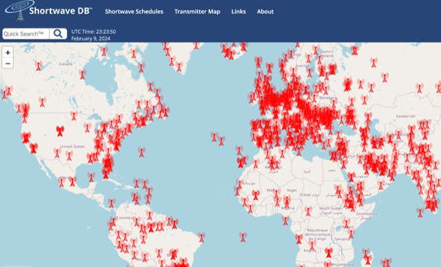 Worldwide Map of shortwave transmitters. Based on shortwave schedule database, this website let you serarch using filters for broadcasts schedule and at the same time to diplay the transmitter map.
 -
 Ham2K PoLo is an android Portable Logger, Support for Parks On The Air (POTA), Summits On The Air (SOTA), Field Day, Winter Field Day, Worldwide Flora and Fauna (WWFF) and more. Fast and efficient yet fully-featured: QRZ.com name lookups, QSO Maps, offline data files, contact rates, duplicate warnings, POTA spots, search parks nearby or by name, etc.