Search results
Query: worldwide regions
Links: 8 | Categories: 3
-
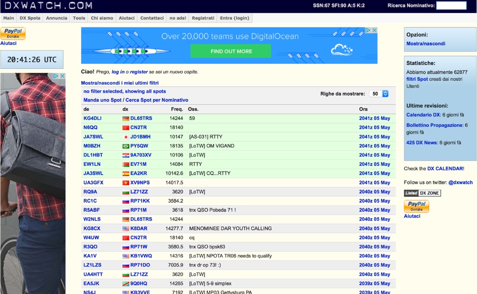 DX clusters aggregate real-time amateur radio spot data, enabling operators to identify active stations and propagation conditions across various bands and modes. DXWatch offers a web-based interface for this essential operating tool, allowing users to filter spots based on specific criteria such as band, mode, or callsign. The service integrates features like a customizable filter system and an external widget for embedding spot data on other platforms, enhancing its utility for DXers and contesters. Operators can access worldwide spot data, with options to zoom into specific regions like the US, Europe, or the North Atlantic, facilitating targeted DXing efforts. The platform also includes a watchlist feature for registered users, enabling personalized tracking of desired stations or entities. Real-time data on solar flux index (SFI), A-index, and K-index are displayed, providing crucial propagation insights alongside the DX spots.
-
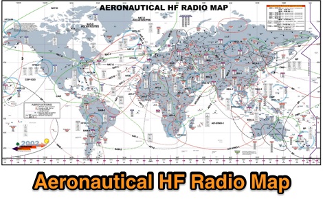 A worldwide map, dated 2002, visually presents aeronautical service frequency allocations across the **HF bands**. This resource details specific frequencies and their designated uses within the aviation sector, providing a geographical context for air traffic control, air-to-air, and air-to-ground communications. It serves as a reference for understanding the structured use of the radio spectrum by aircraft and ground stations globally, particularly for those interested in **radio scanning** or monitoring aviation communications. The map's utility extends to identifying regions and specific frequency ranges where aeronautical activity is concentrated, offering insights into international aviation communication protocols. While dated 2002, it provides a historical snapshot of spectrum management, allowing for comparisons with current allocations and practices. This visual aid assists in pinpointing potential listening targets for scanner operators and those studying spectrum utilization.
-
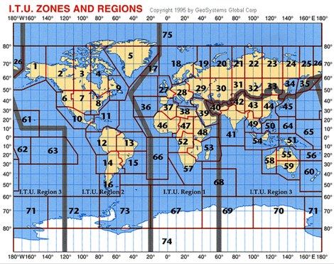 The resource offers a high-resolution JPEG image file depicting worldwide **ITU Zones** and Regions, specifically designed for radio amateurs and technical users. This visual aid clarifies the geographical divisions established by the International Telecommunication Union, which are fundamental for understanding amateur radio operating regulations and DXing awards. Information regarding ITU Regions is referenced from the IARU website, ensuring accuracy for amateur radio operations. The image file is provided in a convenient JPEG format, optimized for clarity and ease of use. Users can freely download this map, which serves as a practical reference for identifying the specific ITU zone of a DX entity or for planning contest strategies based on regional distinctions.
-
 The Voice of America (VOA) website serves as a primary digital platform for its international news and information services, broadcasting in 44 languages. The resource presents a wide array of current events, geopolitical analyses, and cultural reports, reflecting a global perspective on news originating from the United States. Content spans various regions, including Africa, Asia, the Middle East, and specific country-focused reports from VOA's language services, such as VOA Uzbek, VOA Kurdish, and VOA Russian. The site features top stories, special reports, and sections like "All About America" and "VOA Explains," providing in-depth context on US-related topics and global issues. The VOA platform offers a continuous stream of updated news articles, covering political developments like government shutdowns, diplomatic relations, and international conflicts, alongside social and economic issues. It also includes sections for "Worth Watching" videos and "From VOA's Language Services," highlighting the breadth of its multimedia output. The content is designed to inform a worldwide audience, often presenting multiple perspectives on complex international events and US foreign policy, making it a significant reference for those monitoring global news and shortwave broadcast content.
-
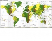 The "Time Zone Map" is presented as a JPEG image file, providing a visual representation of standard time zones across the globe. This resource directly supports amateur radio operations by enabling quick conversion between local times and Coordinated Universal Time (UTC), which is essential for logging contacts, participating in contests, and scheduling DX operations. The map delineates the various time offsets from the prime meridian, offering a practical reference for hams worldwide. Its utility extends to planning international contacts, understanding propagation windows relative to different geographical regions, and ensuring accurate timekeeping for QSL card exchanges. The visual format of the map allows for rapid identification of time differences between a station's location and potential DX targets, simplifying complex time calculations. This specific image file serves as a straightforward, readily accessible operating aid, directly addressing the need for time zone awareness in the amateur radio community. It is categorized under Operating Aids for Travelling, Time, and Maps, reflecting its broad applicability.
-
 The Mississippi QSO Party, sponsored by the Mississippi Section of the ARRL, offers a prime opportunity for hams worldwide to make contact with Mississippi stations. This annual event encourages both in-state and out-of-state operators to activate Mississippi counties, promoting activity across the Magnolia State's diverse geographic regions. Participants often operate from various locations, including parks and historical sites, contributing to the unique character of the contacts. Operators typically utilize a mix of HF and VHF bands, employing CW, SSB, and digital modes to maximize their QSO count and multiplier acquisition. The exchange usually involves a signal report and county for Mississippi stations, or state/province/country for others. Results are compiled and published, recognizing top scorers in various categories and encouraging friendly competition among participants. The event serves as a significant annual gathering point for the Mississippi amateur radio community, fostering camaraderie and operational skill development.
-
 Over 1900 ARISS school events have been conducted since 2000, facilitating amateur radio contacts between students and ISS crew members. This resource details the Amateur Radio on the International Space Station (ARISS) program, outlining scheduled contacts, operational procedures, and application processes for educational institutions worldwide. It lists specific upcoming contacts, such as those with Lewis Center for Educational Research in California and Vauban, Ecole et Lycée français de Luxembourg, typically operating on a 145.800 MHz downlink frequency. The content also provides crucial guidelines for radio amateurs, emphasizing the importance of not interfering with scheduled school contacts and utilizing the crossband repeater for general QSOs when available. It clarifies crew availability for casual contacts, noting that astronauts are usually free during personal time, approximately one hour after waking and one hour before sleeping, and often on weekends. Constraints on scheduling, such as avoiding EVA weeks and specific crew rest periods, are also detailed. Furthermore, the resource includes historical statistics on direct versus telebridge contacts, QSL information, and links to related ARISS, AMSAT, ARRL, and NASA websites. It also provides information on applying to host an ARISS contact for schools and youth organizations in various regions, including the United States, Europe, Africa, the Middle East, Canada, Central and South America, Asia, and Australia.
-
 Documents the XR0ZR DXpedition to Juan Fernandez Island (SA-005) in November 2013, providing insights into activating a highly sought-after DXCC entity. The team's efforts focused on maximizing QSO opportunities across various bands and modes, a critical aspect for stations aiming to complete their DXCC or IOTA awards. Operating from a remote location like Juan Fernandez presents unique logistical and technical challenges, which the expedition successfully navigated to put this entity on the air for thousands of eager DXers worldwide. The resource outlines the operational period, the callsign XR0ZR, and the specific island group activated. Such DXpeditions are vital for the global amateur radio community, enabling hams in less accessible regions to achieve their award goals and fostering international communication. The detailed account serves as a historical record of a significant activation.