Search results
Query: zip code
Links: 8 | Categories: 0
-
 The _59+ Log_ software, part of the 59+ collection, functions as a logging tool for Windows operating systems, specifically tested on Windows XP where its logbook feature operates smoothly. This collection also includes _59+ CW_, a module designed for Morse code operations, enabling keying of the COM port for transceiver control or simply listening to CW signals via the speaker. The software package, originally hosted on idealog.net, is now available for download as 59soft14.zip (3.4 MB) from IW5EDI's site. While the logbook application is functional, the _59+ CW_ application may encounter issues on newer Windows versions, as indicated by a failure to start on Windows XP during testing. The analyzer and convert modules within the 59+ suite require registration and do not operate in trial mode. Development and support for this software have been discontinued.
 -
-
 A circular waveguide calculator for designing cantennas include source code and windows executable by lincomatic
 -
 Generating Morse code audio files from text input is the primary function of _MorseGen v1.2_, a utility designed for amateur radio operators. The software allows users to specify the tone frequency and words-per-minute (WPM) speed for the generated CW. A key feature is its ability to create a WAVE audio file containing the Morse code, which can then be used in various applications. The program also supports repeating the generated CW sequence at user-defined intervals, making it particularly useful for creating station identification signals or beacons. The practical application of this tool extends to automated station identification, especially for repeaters or digital mode gateways that require a CW ident. By producing a standard _WAVE file_, the output is compatible with most audio playback systems and software. This functionality provides a straightforward method for integrating custom Morse code messages into existing amateur radio setups, eliminating the need for external hardware keyers for simple identification tasks. The adjustable parameters offer flexibility to match specific operational requirements or personal preferences for CW characteristics.
 -
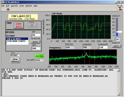 Deciphering weak or noisy **CW** (Continuous Wave) signals often presents a challenge for amateur radio operators, particularly in contest environments or during DXpeditions. CWLab04X addresses this by providing a software solution that leverages **DSP** (Digital Signal Processing) capabilities of a soundcard to decode Morse code. It functions as both a receiver and a sender, supporting traditional CW and a unique "CCW" mode designed to enhance copyability of signals struggling against high noise floors. The program offers two installation methods: a Windows-specific installer for straightforward setup or a zipped package compatible with Windows and Linux systems running Wine. Users must first download and review the accompanying PDF documentation, CWLab04.pdf and CWLab04_Hardware.pdf, which detail the software's operation and the necessary soundcard interface circuit. The hardware PDF outlines a direct connection from the receiver audio output to the soundcard input, with optional conversion of the soundcard output for hard-keying or microphone input. CWLab04X is intended as an operational aid rather than a replacement for skilled human copy, particularly highlighting the effectiveness of its CCW mode in adverse signal conditions. The software was last revised in April 2009, with installation requiring the LV Runtime 602.
 -
 Demonstrates a practical online tool for locating amateur radio operators by geographic area, specifically using US ZIP codes. This utility allows users to input at least three digits of a desired ZIP code to retrieve a list of active licensees. Search results can be sorted by _call sign_, name, license expiration date, or ZIP code, providing flexibility in data organization. The service offers two primary output formats: direct display in a web browser, which omits address details for privacy, or export to a tab-delimited file, which includes full address information suitable for import into spreadsheet or database applications like _Excel_. This lookup service proves useful for local club organizers seeking to identify potential members within their service area or for hams planning local nets or events. The ability to export data with address details facilitates direct mailings for club newsletters or event announcements, while the browser view maintains privacy for casual lookups. The tool's design prioritizes ease of use, requiring minimal input to generate relevant local amateur radio contact information.
 -
 The resource provides an interactive map interface for locating amateur radio license holders across the United States. Users can input a _callsign_, _gridsquare_, zip code, or street address to center the map, which then dynamically populates with station markers. This functionality allows for precise geographical searches, revealing the distribution of hams within specific areas. Upon initial search, the map renders with adjustable zoom and pan capabilities. A key feature is its automatic reload mechanism: after two seconds of inactivity, the map updates to display stations within the newly viewed area. This ensures that the displayed data remains relevant to the user's current focus, whether exploring a densely populated urban center or a more remote region. Further interactive elements include clickable gridsquare labels, which re-center the map, and a "Show gridsquares" checkbox for toggling grid line visibility. Clicking on individual station markers reveals a popup containing the licensee's name and address information, making it a practical tool for geographical station identification.
 -
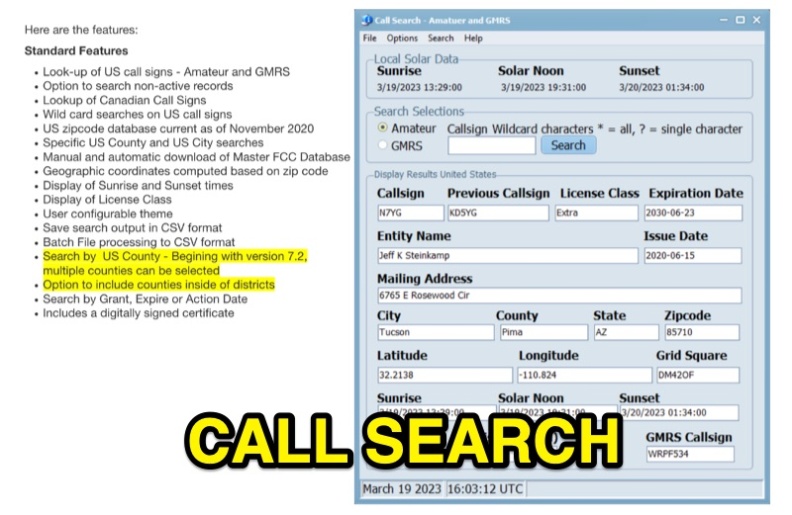 Callsearch is a Windows-compatible software application, version 7.3.6.1, designed for looking up **US** and **Canadian** amateur radio **call signs**, as well as US GMRS call signs. It replaces the previous FCC Lookup program, offering similar functionality with some scaling down, notably replacing Ten-Ten lookup with GMRS call sign search. Key features include searching active and non-active US records, wild card searches for US call signs, and specific US county and city searches using a November 2020 zipcode database. The software provides geographic coordinates, sunrise/sunset times, and license class display. Users can configure themes, save search output in CSV format, and perform batch file processing to CSV. Version 7.2 and later support multiple county selections and an option to include counties within districts. It includes a digitally signed certificate and supports manual and automatic updates of the Master FCC Database. The program runs on Windows 32 and 64-bit platforms, and on Mac and Linux using the WINE emulator with WINEPFX set for Windows 8 or later.