Search results
Query: gps time
Links: 20 | Categories: 1
Categories
-
 Select your favorite satellite and watch its trajectory on Google Maps in real time! Includes ISS tracking, Weather, Geostationary, GPS Military, and of course Amateur radio satellites. N2YO provides comprehensive real-time satellite tracking with particular emphasis on amateur radio satellites. The service offers precise pass predictions calculated for user-specific locations, displaying upcoming passes with azimuth, elevation, and duration data essential for ham operators planning satellite contacts. N2YO features dedicated tracking for amateur radio satellites including FM, linear transponder, and digital satellites, with frequency information and downlink/uplink details. The platform delivers live tracking visualizations on interactive maps, Doppler shift calculations, and automated email notifications for upcoming passes. This free resource integrates weather satellite tracking alongside NOAA imagery, making it invaluable for radio enthusiasts pursuing satellite communications.
 -
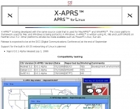 APRS for Linux is a multifaceted system for use with packet radio by Hams, it allows the monitoring of real time geographical information such as the position of vehicles, the status of weather, radio direction finding and much much more. It envolves mapping, GPS tracking, packet radio, etc
 -
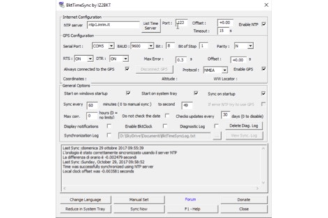 BktTimeSync synchronizes the PC time using an internet time server (NTP server) or a GPS receiver connected to USB, serial port or Bluetooth. Great for use with digital modes like FT8, JT65, JT9, JS8Call and others. For the operation of this program requires an active internet connection or a GPS receiver. This program works on all versions of Windows 32 or 64 bit
 -
 A means of sync-ing your computer clock using a GPS Receiver. GPS2Time is another GPS network time synchronization software application for Window 7 and higher. Freeware.
 -
 We are committed to constantly improving our solutions in areas of GPS System, GPS Receivers, GPS Antennas, GPS Dataloggers, RF Modules, Wireless Security Systems, Automatic Vehicle Location (AVL) for real time and passive tracking
 -
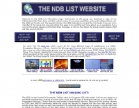 Presents a detailed resource for DXers interested in Non-Directional Radiobeacons (NDBs), MF, HF, and VHF propagation beacons, and various other radiobeacon types. The site offers access to downloadable information files, including an Abbreviations List, NDB List Country List, and NDB Publications List, which serve as foundational materials for newcomers to the hobby of beacon monitoring and DXing. It covers specialized topics such as DGPS beacons, GMDSS DSC mode, and NAVTEX mode, with dedicated sections providing in-depth explanations. A Beacon Photo Gallery showcases diverse radiobeacon types from around the globe, offering visual context for different systems encountered in the field. The platform also facilitates participation in unique monthly Coordinated Listening Events (CLEs), providing guidelines and schedules for these activities. The resource outlines various associated Groups.io lists, including the primary NDB List for radiobeacons (NDBs, Propagation Beacons, VOR systems), the DGPS List for DGPS DXing, Time Signals, LORAN, and WeFAX modes, and specialist groups like NavtexDX and DSC List for GMDSS-DSC. It details how to join these communities for further engagement and information exchange.
 -
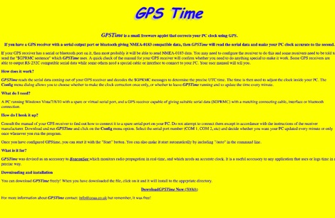 GPSTime is a small freeware applet that corrects your PC clock using GPS. GPSTime reads the serial data coming out of your GPS receiver and decodes the $GPRMC messages to determine the precise UTC time. Works on Windows Vista/7/8/10 with PC with serial ports.
 -
 The _ISS Detector_ Android application, with over 5 million downloads, offers precise predictions for visible passes of the International Space Station. It notifies users minutes before an overhead pass, integrating local weather conditions to ensure optimal viewing opportunities. The core functionality focuses on the ISS, but in-app purchases extend its capabilities to track other celestial and artificial objects. Optional extensions, available via in-app purchase, allow users to monitor dozens of amateur radio and weather satellites, providing real-time transmitter information and Doppler frequencies. Additional extensions cover _Starlink_ satellites, the _Hubble Space Telescope_, rocket stages, bright satellites, comets, and planets, expanding the scope beyond the ISS to a broader range of observable space phenomena. The app's interface is designed for ease of use, displaying pass times, directions, and elevation. It adapts predictions based on the user's GPS location, ensuring accurate local forecasts. The latest update, dated April 3, 2026, includes corrections for magnitude values and various speed and stability optimizations.
 -
 The CES Wireless Technologies website details a range of **GPS fleet tracking** solutions designed for mobile information systems. It highlights offerings such as dispatch and mapping software, Automatic Vehicle Location (AVL) systems, and mobile data display terminals. The platform also mentions support for Automatic Number Identification (ANI) and Continuous Tone-Coded Squelch System (CTCSS) functionalities, indicating integration with two-way radio communication protocols. Specific products include GPS tracking devices and associated software for fleet management, emphasizing features like real-time location monitoring and operational efficiency. The site positions itself as a manufacturer in this specialized domain, catering to commercial and public safety sectors requiring robust mobile data solutions. While the page title mentions "Ham Radio Directory" categories, the content primarily focuses on commercial GPS and fleet management technologies, not amateur radio applications. The listed products are geared towards professional mobile radio (PMR) environments rather than typical ham radio operations.
 -
 As FT8, JT65 and JT9 are a time synchronized protocol, one soon discovers that an accurate PC clock is very important. If your workstation time is off it can cause you to send when no one is listening, or to listen when no one is sending.
 -
 Spectrum manufactures very high-performance, low-cost, GPS-disciplined time and frequency reference standards for industry, scientific, calibration, broadcast and amateur operators.
 -
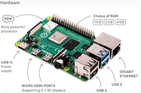 This resource is an online tutorial focused on setting up the Raspberry Pi for amateur radio applications. It covers the installation and configuration of various software packages tailored for digital communications and protocols, including _Packet Radio_ with Hamlib and Direwolf, as well as data modes like FLDigi and WSJT-X. The guide also details the integration of hardware components such as GPS clocks for time synchronization and real-time clocks for enhanced functionality. Users will find instructions for installing software like GPredict for satellite tracking and GQRX for software-defined radio (SDR) applications. The tutorial emphasizes practical steps, including the use of command-line inputs in the Raspberry Pi OS terminal, and provides troubleshooting tips for common issues such as faulty SD cards or insufficient power supplies. Operators are encouraged to explore various applications, including APRS iGates and WSPR beacons, to enhance their ham radio experience. The material is designed for licensed amateur radio operators with basic knowledge of electronics and computing.
 -
 Low-frequency (LF) radio time signals, operating primarily in the 40–80 kHz range, are broadcast by national physics laboratories for precise clock synchronization. Transmitters like **JJY** (40 kHz, 50 kW; 60 kHz, 50 kW), RTZ (50 kHz, 10 kW ERP), MSF (60 kHz, 15 kW ERP), WWVB (60 kHz, 50 kW ERP), RBU (66.66 kHz, 10 kW), and DCF77 (77.5 kHz, 50 kW) cover vast geographic areas, often several hundred to thousands of kilometers. LF signals offer distinct propagation advantages over higher-band transmissions such as GPS. Their long wavelengths (3–6 km) enable effective diffraction around obstacles like mountains and buildings. The ionosphere and ground act as a waveguide, eliminating the need for line-of-sight and allowing a single powerful station to cover extensive regions. Ground wave propagation minimizes ionospheric variability effects on transmission delay, and signals penetrate most building walls effectively. Robust and low-cost receivers, often priced at 20–30 USD/EUR, are widely used in radio clocks. These receivers typically comprise a tuned ferrite core antenna, a receiver IC (e.g., Atmel T4227, U4223B, MAS1016) for amplification and AM detection, and a microcontroller for decoding the time signal and phase-locking a local clock. Specific components for DCF77, MSF, and WWVB are readily available from vendors like HKW Elektronik and Ultralink.
 -
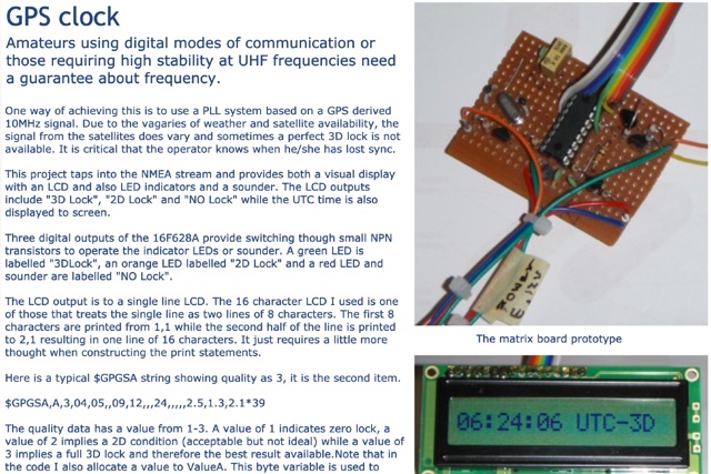 This project taps into the NMEA stream and provides both a visual display with an LCD and also LED indicators and a sounder. The LCD outputs include 3D Lock, 2D Lock and NO Lock while the UTC time is also displayed to screen.
 -
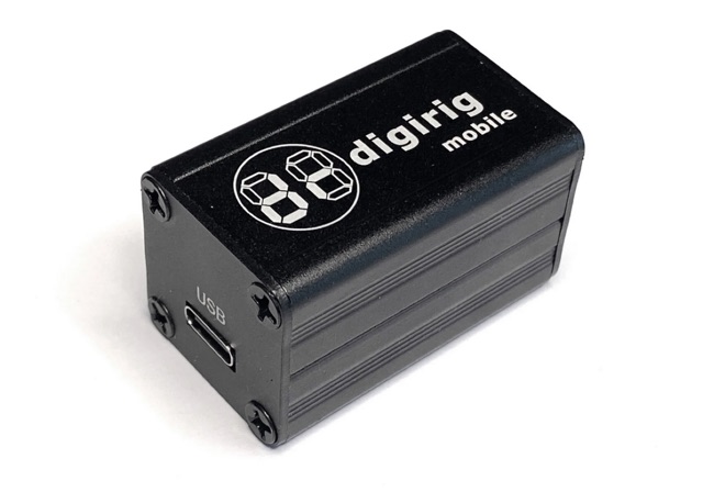 Digirig is an open-source integrated digital modes interface for amateur radio. As a differentiating feature, Digirig only requires a single USB connection to the computer with all the digital goodness packed in a single small enclosure. The internals include a USB hub, audio codec, a fully featured serial CAT (Computer Aided Transceiver) interface, and potentially other modules such as GPS receiver for time synchronization.
 -
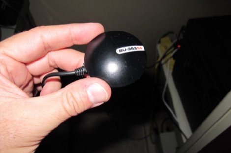
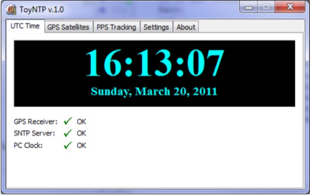 ToyNTP is a simple freeware time server for Windows that implements the SNTP protocol and uses a GPS receiver, Garmin GPS 18x LVC, as time reference. ToyNTP was designed to be used with Faros in the locations where access to the SNTP servers on the Internet is not available, but it may be used for other purposes as well, in particular, it may be configured to keep the PC clock synchronized to a GPS receiver.
 -
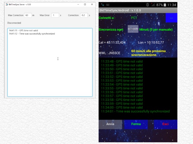 BktTimeSyncPhone synchronizes the PC time using the smartphone GPS connected via Bluetooth. Great for use with digital modes like FT8, JT65, JT9, JS8Call and others, especially when you do not have internet connections. To run this program, you need to install BktTimeSyncServer on your PC and the BktTimeSyncAndroid app on your smartphone. The program works with all versions of Windows 32 or 64 bit and requires Java version 8 or higher. The app requires an Android smartphone version 4.4 or higher.
 -
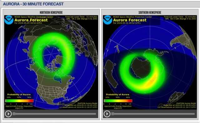 The short-term aurora forecast, based on the OVATION model, predicts aurora location and intensity 30 to 90 minutes ahead, aligning with solar wind travel time. Maps show aurora ovals in green, turning red for higher intensity. Aurora, visible after sunset or before sunrise, impacts technologies like radio communication, GPS, and power grids. It's a mesmerizing space weather spectacle, drawing travelers to the Arctic.
 -
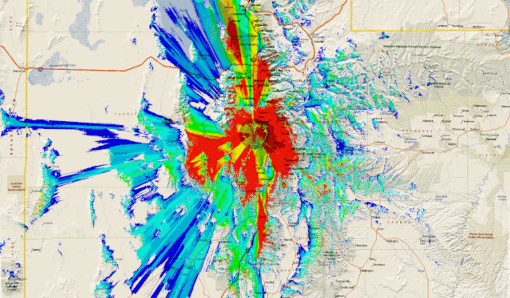 This study analyzes the antenna pattern of the Utah Amateur Radio Club's 146.760 MHz repeater following antenna relocation in 1997. Noting degraded transmission toward the north, a customized signal mapping system using a Yaesu FT-817, GPS, and software was developed to log real-time signal data. Calibration techniques extended the radio's signal range, enabling precise field measurements. The method allowed continuous signal strength monitoring while driving, revealing anomalies in coverage likely due to tower modifications. Findings helped assess and visualize the antenna’s actual radiation pattern and highlighted environmental impact on signal distribution.
 -
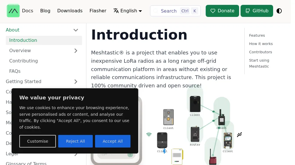 Meshtastic utilizes _LoRa_ radio protocol for long-range, off-grid communication, functioning as a decentralized mesh network. The system allows users to send and receive text messages without reliance on existing infrastructure or a phone for mesh communication, leveraging inexpensive LoRa radios. Key features include encrypted communication, excellent battery life, and optional GPS-based location services, with radios designed to rebroadcast messages to ensure all group members receive them. The project has achieved a record range of **331km** and is 100% community-driven and open source, with its codebase available on GitHub. Unlike traditional ham radio, Meshtastic operates on LoRa, which is generally accessible without additional licenses. Each Meshtastic radio can be paired with one phone at a time for message exchange, and support is entirely volunteer-based.