Search results
Query: sunrise
Links: 9 | Categories: 0
-
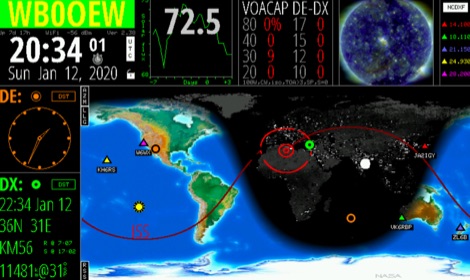 Keep track of much more than the time with this Wi-Fi enabled device. HamClock is a desk clock that could show accurate time, geography, time zone, solar activ- ity, sunrise and sunset times, Maiden- head locators, beam heading,
 -
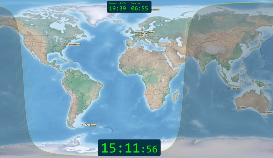 Free windows world map application display current time, sunrise and sunset, greyline map, dx stations, requires windows 7 or higher. The program includes three resized Natural Earth maps which have been resized to 4k or slightly less. By Simon Brown G4ELI better known as the inventor of Ham Radio Deluxe.
 -
 The 160-meter amateur radio band, spanning 1.8 to 2 MHz, was historically the lowest frequency amateur allocation until the introduction of the 630-meter and 2200-meter bands. ITU Region 1 allocates 1.81–2 MHz, while other regions use 1.8–2 MHz. This band, often called "Top Band" or "Gentleman's Band," was established by the International Radiotelegraph Conference in Washington, D.C., on October 4, 1927, with an initial allocation of 1.715–2 MHz. Effective operation on 160 meters presents significant challenges due to the large antenna sizes required; a quarter-wavelength monopole is over 130 feet, and horizontal dipoles need similar heights. Propagation is typically local during the day, but long-distance contacts are common at night, especially around sunrise and sunset, and during solar minimums. The band experienced a resurgence after the LORAN-A system was phased out in North America in December 1980, leading to the removal of power restrictions.
 -
 The DXCC World Map web application is a modern and interactive mapping tool designed for shortwave radio enthusiasts. It showcases a high-quality world map along with the Sun's position, sunrise and sunset times, the terminator, coordinates, QTH locator, azimuth, azimuth map, current DXCC list, Aurora, and WWV Geophysical Alert Messages. Additionally, it provides the SFI, X-Ray, Kp, and Ap indices.
 -
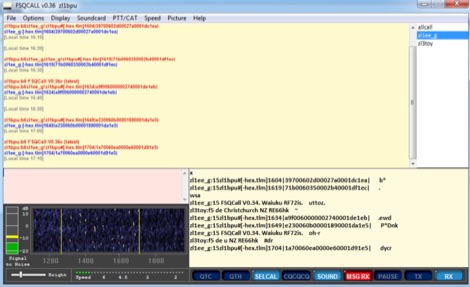 FSQ is a Fast Simple QSO mode designed specifically for HF. It works well under NVIS and sunrise/sunset conditions on the lower bands, and also works well for short skip and grey-line on higher bands and can be used also on VHF FM.
 -
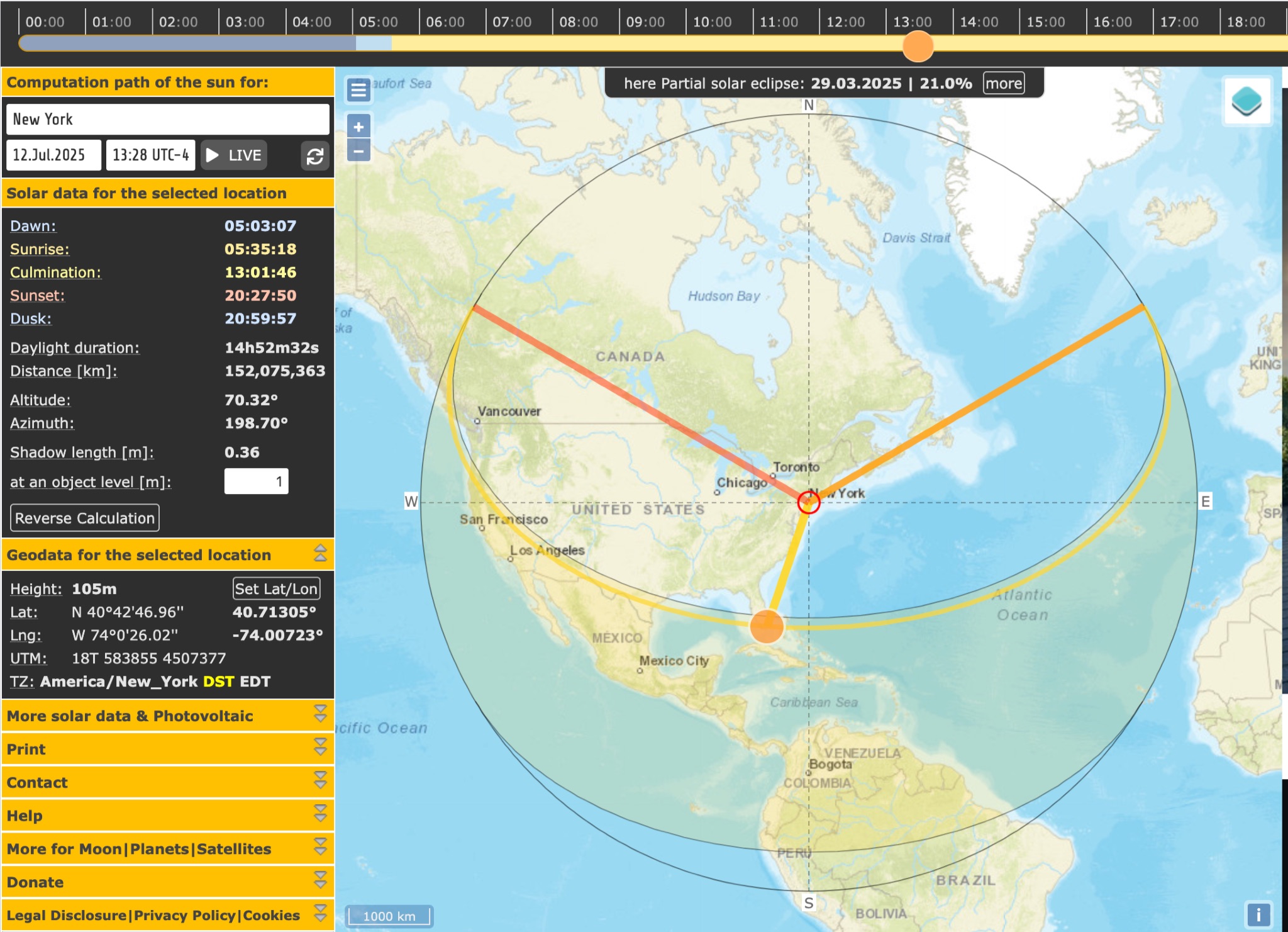 SunCalc is a tool that displays the movement of the sun and sunlight phases for a specific day and location. Users can adjust the sun's positions for sunrise, selected time, and sunset. The visual representation includes a curve showing the sun's trajectory and variations throughout the year. The tool also provides information on sunlight distribution during the day. SunCalc is useful for hams wanting to plan outdoor activities based on sunlight availability and position. Users can support the website's maintenance with a donation via PayPal.
 -
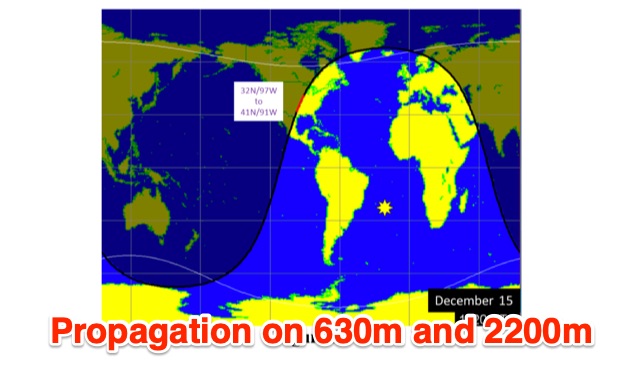 This is a theoretical look at propagation on 630-Meters and 2200-Meters using ray tracing software. It expands on the brief discussion in the ARRL Handbooks. The Earth's magnetic field affects 630-Meter and 2200-Meter band propagation. Lower ionization reduces absorption, aiding low-frequency propagation. Differences exist between bands, limited daytime sky-wave propagation. Sunrise/sunset show promise, yet mechanisms are unclear. Ducting possible at night in specific conditions. Negative ions enhance propagation. Inefficient antennas and high man-made noise are anticipated. Groundwave propagation is significant on 2200-Meters.
 -
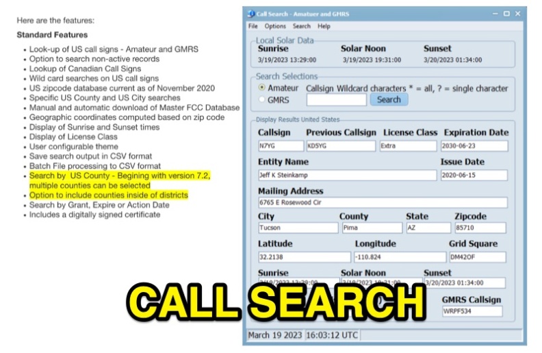 Callsearch is a Windows-compatible software application, version 7.3.6.1, designed for looking up **US** and **Canadian** amateur radio **call signs**, as well as US GMRS call signs. It replaces the previous FCC Lookup program, offering similar functionality with some scaling down, notably replacing Ten-Ten lookup with GMRS call sign search. Key features include searching active and non-active US records, wild card searches for US call signs, and specific US county and city searches using a November 2020 zipcode database. The software provides geographic coordinates, sunrise/sunset times, and license class display. Users can configure themes, save search output in CSV format, and perform batch file processing to CSV. Version 7.2 and later support multiple county selections and an option to include counties within districts. It includes a digitally signed certificate and supports manual and automatic updates of the Master FCC Database. The program runs on Windows 32 and 64-bit platforms, and on Mac and Linux using the WINE emulator with WINEPFX set for Windows 8 or later.
 -
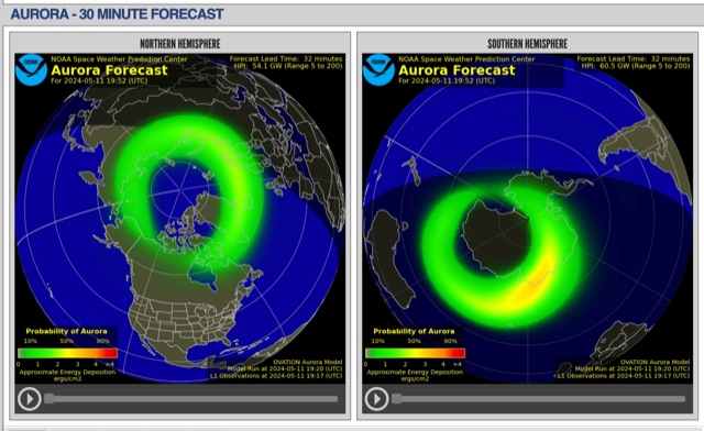 The short-term aurora forecast, based on the OVATION model, predicts aurora location and intensity 30 to 90 minutes ahead, aligning with solar wind travel time. Maps show aurora ovals in green, turning red for higher intensity. Aurora, visible after sunset or before sunrise, impacts technologies like radio communication, GPS, and power grids. It's a mesmerizing space weather spectacle, drawing travelers to the Arctic.