Search results
Query: custom map
Links: 26 | Categories: 0
-
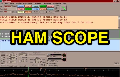 HamScope v1.56, released on 2007-03-20, functions as a multi-mode communications interface for amateur radio, supporting digital modes such as PSK31 (BPSK and QPSK), RTTY, ASCII, MFSK16, PACKET, and CW. The software integrates with external engines like _MMTTY_ for RTTY/ASCII and AGWPE for PACKET operation. It features a panoramic waterfall display, 42 user-programmable macro buttons, and user-definable function key mappings, providing operators with enhanced control during digital mode operations. The program includes a radio control interface compatible with several ICOM, TenTec, Kenwood, and Yaesu transceivers, enabling direct rig control. HamScope also establishes data links with various logging and radio control applications, including LOGic 7/8, DXbase 2004, RYLogit, and TRX-Manager, facilitating seamless data exchange and logging. A DDE server is available for custom connections. Designed for Windows 98 and NT, HamScope requires a 133 MHz Pentium-class machine and 16-bit SVGA color. While not officially supported, users have reported functionality on Windows 95, ME, XP, and 2000, though some issues with window settings or the MMTTY engine may occur. The software is distributed as a single executable file, with separate downloads required for MMTTY and AGWPE engines.
 -
 Footprint Satellite Tracker is a satellite tracking software that provides real-time monitoring of satellite movements worldwide. It features a global map with celestial markers and allows users to adjust time settings to predict satellite paths. Customizable options include location coordinates and time zones. Users can analyze satellite ephemeris and print reports, though file-saving requires a virtual printer. Despite its research utility, the software supports a limited satellite list and lacks options for manual data source connections. Current version has been tested running on Windows 10.
 -
 The page provides a tool to create a customized Ham Radio Az Map on the fly, with various dimensions available. It is a valuable resource for amateur radio operators to visualize and optimize pointing of directional antennas. The content includes maps for different regions, prefix maps, and world maps.
 -
 Amateur Contact Log (AC Log) by N3FJP is a commercial Windows-based general logging program designed for amateur radio operators, supporting Windows 7 through 11. It provides comprehensive tracking for various operating awards, including Worked All States (WAS), Worked All Counties, Worked All Countries (WAC), DXCC, VUCC, Grids, Zones, IOTAs, and Lighthouses. The software features a customizable user interface, allowing operators to display specific data fields and adjust font sizes. It includes built-in databases for counties and countries, facilitates queries by band, mode, or power level, and offers a bearing and distance calculator for DX contacts. AC Log also provides DX spotting via Telnet or packet TNC, supports keyboard CW, and can play wave files. The program offers full support for ADIF import and export, enabling seamless integration with external services like eQSL, QRZ, Club Log, and the ARRL's Logbook of the World (LoTW) for QSO uploads and confirmation downloads. It interfaces with popular transceivers from Elecraft, Icom, Kenwood, Ten Tec, and Yaesu, and connects with digital mode software such as WSJT-X, Fldigi, and JTAlert via API. AC Log includes a Net Manager form for group logging, prints basic QSL label strips, and integrates with QRZ and Ham Call lookup services. The software is fully networkable for multi-PC operation, supports Parks on the Air (POTA) logging, and displays worked entities and DX spots on a real-time world map. Full featured Trial version available for 45 days
 -
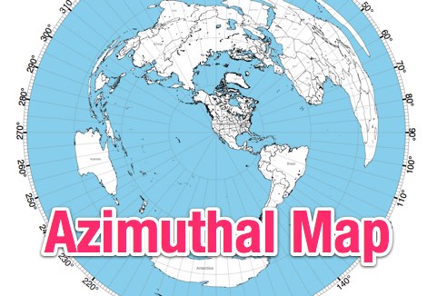 This site provides free azimuthal maps for almost anywhere on the globe. Create your own azimuthal map for your location. You can customize the map in a variety of ways by changing the options in the web form
 -
 Demonstrates BBLogger, a **freeware** logging application designed for both amateur radio operators and Short Wave Listeners (SWLs). Developed by IK2VIW, IZ2BKT, and IK2UVR, this software provides comprehensive station management capabilities, including **CAT control** for various transceivers, integration with digital mode software like WSJT-X, JTDX, and MSHV, and robust QSL management features. The application supports a wide array of functions such as DX cluster interfacing, mapping, awards tracking (including custom awards), and direct integration with services like LoTW, eQSL.cc, and ClubLog for QSL confirmations and OQRS requests. It also includes utilities for ADIF to CSV conversion and vice-versa, catering to diverse logging and data management needs. Recent updates, such as version 13.1, introduce a web server for log management from any device, allowing remote access and control. The software has improved ADIF import capabilities, including time settings for duplicate QSO detection, and enhanced filtering options for log searches. Performance improvements include faster automatic updates and manager database synchronization, along with optimized log checking at startup. Earlier versions added support for FT8 and FT4 modes, refined OQRS integration with ClubLog, and expanded QSL/label printing functionalities, enabling users to select specific callsign types (OM, SWL) for printing. The developers emphasize compatibility with Windows 10/11 for full functionality, noting limitations when running on older operating systems like Windows 7 due to modern security protocol requirements.
 -
 adsbScope is a freeware Windows application designed for processing _ADS-B_ (Automatic Dependent Surveillance-Broadcast) frames received from a compatible decoder. It identifies aircraft, calculates their real-time positions, and presents flight parameters in both alphanumeric tables and a graphical display. The software interfaces via a virtual COM port, receiving raw frames to provide detailed situational awareness, including a global coordinate grid, continental coastlines, over 4,000 **airport** locations, and major cities. Users can overlay OpenStreetMap tiles and view world state boundaries, with each tracked aircraft rendered with labels showing altitude, speed, heading, squawk code, and flight identifiers. When paired with the adsbPIC-decoder, adsbScope enables advanced hardware control, allowing users to toggle data filters for specific frames like DF17/18/19, adjust analog signal thresholds for reception fine-tuning, and manage system resets or bootloader activation directly from the PC. This functionality provides a customizable toolkit for hobbyist radar listeners, offering a robust alternative to commercial tools for processing aircraft data. The software displays up to **1090 MHz** transponder data and can track aircraft up to 250 nautical miles.
 -
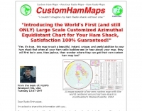 The webs premier site for custom ham maps (azimuthal equidistant projection maps) and great circle bearing/distant charts for the radio amateur. Customized azimuthal equidistant projection maps and tables.
 -
 VQLog 3.1 - 782 is a shareware logbook program designed for Windows operating systems (95, 98, NT, 2000, ME, XP, Vista, 7, 10, or later), supporting resolutions of 800x600 or higher. It can also operate on macOS and Linux via virtualization software like Virtual PC for MAC, Oracle VirtualBox, or VMware. The software facilitates QSO access by date, callsign, prefix, square, DXCC, and other parameters, offering robust import capabilities for ADIF, Cabrillo, and ASCII files from various contest and logbook programs. Key features include comprehensive award tracking for DXCC, WAZ, WAC, WPX, WAS, IOTA, TPEA, DIE, VUCC, 100EACW, and up to 30 user-defined awards. It generates customizable summaries and graphical statistics for QSO activity, DX contests, Most Wanted Squares (MWS), propagation openings, and prefixes. VQLog supports DX-Spot reception and processing from DX-Cluster and PSK-Reporter with programmable warnings, integrates with callbook services like QRZ.COM and Buckmaster's CD, and offers online lookup. Electronic QSL and log upload support extends to LoTW, eQSL.cc, Clublog, and DXMAPS, with real-time updates for online logs. The program provides extended QSO information for VHF-DXers, including separate TX/RX frequencies, start/end times, propagation modes, and specific entry fields for MS, EME, and Tropo. CAT support for rig control and interfaces with ARSWIN and PstRotator for azimuth/elevation control are also included.
 -
 TAHO.EXE, an open-source software, facilitates the creation of APRS maps for _UI-View_ by converting free data from _OpenStreetMap_ into the required *.JPG and *.INF file formats. This utility, developed by Dimitri Junker with specific UI-View format support added at the request of HB9DTX, streamlines the process of integrating detailed geographical information into the _UI-View_ platform. It operates on Windows, generating map files with border coordinates in just a few clicks, eliminating the tedious manual creation of *.INF files for custom maps. This converter allows UI-View users to leverage the continuously updated and community-contributed data of OpenStreetMap, which often surpasses commercial map quality in specific regions. The process is straightforward, with a detailed step-by-step guide available on the OpenStreetMap wiki, translated into French and German. TAHO.EXE significantly enhances the utility of UI-View by providing a readily accessible and continuously improving source of detailed, current geographical maps for displaying APRS station positions and objects.
 -
 Over 47 full-screen maps are available within _NAOMI_ (North American Overlay Mapper), a free Windows program designed for US and Canadian amateur radio enthusiasts. This mapping suite includes 9 backgrounds such as CQ Zones, ITU Zones, and ARRL Sections, along with 16 foreground layers like Counties, Areacodes, and Grid Locators. Users can calculate distances and bearings, track real-time mouse positions with continuous Grid-Locator data, and integrate with APRS for live station tracking via the FindU database. For a global perspective, the _Global Overlay Mapper_ (GOM) provides a world map, 8 continental maps, and 29 sub-continental maps, all with 12 active layers including Country Outlines, CQ/ITU Zones, and Prefix information. Both NAOMI and GOM offer feature-locate systems to jump to positions based on prefixes, capital cities, or Grid Locators, and provide customized beam headings and distance displays. The site also features _LogView_, a post-contest log visualization tool that analyzes Cabrillo-format logs by plotting QSOs on maps, supporting over 30 major contests like CQWW and ARRL DX, and allowing comparison with published results.
 -
 Xastir MacOSX APRS software for receiving and plotting APRS(tm) position packets. Xastir supports many map formats and is highly customizable
 -
 A 2x3-foot laminated world map product is detailed, offering customization for amateur radio operators. Each map features two distinct views: one centered on the operator's specific station location and another precisely centered on its _antipode_. Countries are clearly labeled, complemented by a tabular listing of all countries. The map integrates a standard latitude/longitude grid alongside concentric circles that delineate distance increments radiating outward from the operator's QTH. Personalization includes the operator's name, callsign, and location printed directly on the map. This custom mapping service provides a unique visual aid for DXing and propagation analysis, allowing operators to quickly ascertain beam headings and distances from their station. The dual-view presentation, particularly the antipodal centering, offers a practical reference for understanding long-path propagation and identifying potential DX opportunities. The inclusion of distance circles and personalized station data makes it a tailored tool for daily operating and contest planning, distinct from generic world maps.
 -
 Sw tool to design point-to-point multi-hop microwave links and networks, 400MHz to 58 GHz. Site/Hop Configuration; Customized Antenna & Radio Equipment Libraries; Link Budget; Path Profile Analysis ,clearance, reflections; import path profiles from SRTM maps, free download.
 -
 OpenHamClock is a modern, open-source dashboard for amateur radio operators, designed as a web-based successor to the original HamClock. Deployable locally on a Raspberry Pi or via the cloud, it centralizes essential DX operations into a single, intuitive interface. At its core is an interactive world map that visualizes real-time DX spots, signal paths, satellite tracking, and POTA activators. The software seamlessly integrates critical tools like WSJT-X, DX Cluster, and PSKReporter for monitoring digital traffic. Additionally, it provides vital environmental data, including real-time space weather indices, solar activity, and personalized HF propagation predictions. With customizable themes and a modular architecture, OpenHamClock offers modern operators comprehensive, at-a-glance situational awareness of global radio conditions
 -
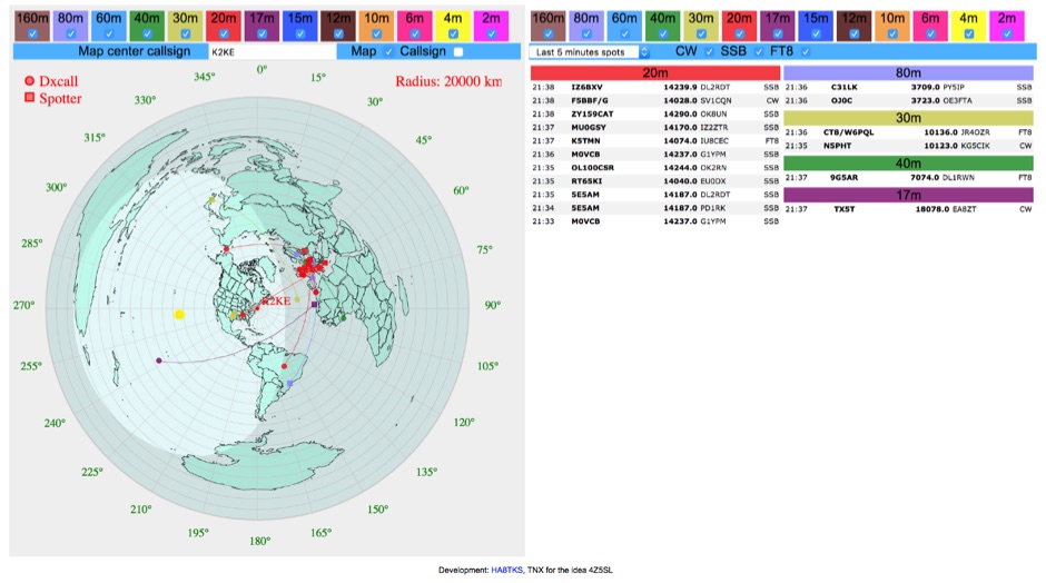 DXCluster spots rendered on a Real-Time Azimuthmal Map centered on a custom callsign
 -
 DX Maps provides a specialized map printing service, focusing on amateur radio applications such as world prefix maps and custom great circle projections. The platform allows radio operators to visualize propagation paths and DX entities relevant to their QTH and operational goals. This service supports the creation of high-quality, large-format maps tailored for shack display or operational planning. The service facilitates the generation of personalized maps, which can include specific callsign locations, beam headings, and other critical amateur radio data points. Users can specify parameters to create maps that aid in understanding global propagation conditions and optimizing antenna aiming for long-distance contacts. The UK-based operation ensures a localized service for European hams, with international shipping options available. DX Maps also offers QSL card printing, complementing its mapping services.
 -
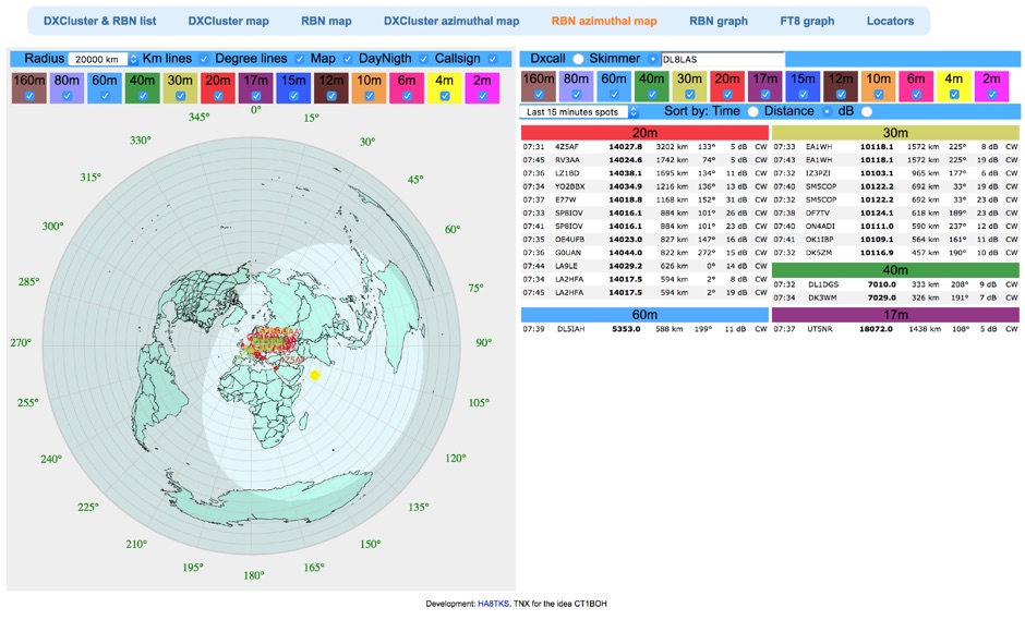 Reverse Beacon Network (RBN) remdered in a Real-Time Azimuthmal Map centered on a custom call sign
 -
 Time Mapper UHD is a versatile mapping and time visualization program offering multi-satellite viewing with frequency display and unique country-pairs for PskReporter data. It features live feeds from logging programs and can plot ADIF files. Ideal for schools, offices, or amateur radio stations, it provides customizable 4K or HD world clock displays with over 60 map layers, including ham radio zones and natural features. The program supports various time functions and can import logs for detailed analysis. It runs on Windows 10 or 11 and offers a 30-day free trial.
 -
 MLog 0.8d is a freeware logging software designed for Windows operating systems (NT, 98, ME, 2000, XP) that facilitates the logging, management, and analysis of amateur radio QSOs. It features a customizable input mask for rapid contest logging, a robust search function for existing contacts, and immediate data storage in CSV format to prevent data loss. The software also includes a double-check mechanism against reference logs during callsign entry, integrated DXCC information, and a "magic field" for streamlined data input, all within a single-window interface. Key functionalities include graphical QSL card management via _QSL-Collection_, CW output through soundcard or PC speaker, and direct access to _Radio Amateur Callbook_ data. MLog supports transceiver control via _Ham Radio Deluxe_ URLs, offers a detailed world map with locator conversions, and can launch _VOACAP_ through _HamCap_. It provides extensive data analysis options for QSLs, _Locator_ large fields, _DOKs_, _DXCCs_, QSO counts, and user-defined contest evaluations, alongside flexible import/export capabilities for various log formats.
 -
 Hamradio_copilot is an open-source tool designed for DXers and contesters who need real-time situational awareness. It is ideal for operators who want to visualize propagation trends instantly rather than scrolling through raw text streams of cluster spots. Rally acting as a copilot for your station, this tool transforms raw data into actionable intelligence. By visualizing Signal-to-Noise Ratios (SNR) across different bands, it helps operators make quick decisions on which band to prioritize or where to point their antennas, effectively showing not just who is on air, but where the propagation is currently open from your location. This is a fantastic information for avid contesters. The software aggregates data from two primary services: - Reverse Beacon Network (RBN) via Telnet. - PSK Reporter via MQTT feeds. It processes this data to generate a comprehensive HTML report featuring SNR heatmaps and statistical breakdowns by ITU Zone. Users can filter data by specific zones or country codes (ADIF), analyze historic time ranges, and optionally integrate solar weather data. The complete source code is available on GitHub, allowing for community customization. It is written in Python and uses SQLite for data management.
 -
 Spotty leverages Philip Gladstone’s pskreporter.info data, delivered via an MQTT broker by Tom Fanning (M0LTE), to offer a responsive web application for visualizing propagation. The Map View presents a default visualization (grid AA00 / callsign MY8CALL) and distinguishes signal types: small spots for signals heard by a location, large spots for transmissions from a location, and teardrop markers for transmissions from the monitored callsign. Clicking a spot reveals detailed signal data in an overlay. The application includes a Log View for raw spot data and a Settings tab for customization. Users can filter tracking by specific Callsign or Grid, with preferences saved to the browser. A notable feature is the Time to Live (TTL) setting, adjustable from the default 60 seconds, which controls spot visibility duration to manage map clutter during high-traffic periods. The tool provides a clear, logic-driven interface for real-time signal monitoring.
 -
 AZIWORLD is a user-friendly tool for generating azimuthal maps of the Earth centered on any location. Compatible with Windows XP and later, it supports English and French. Maps can be saved in .bmp format for easy customization. AZIWORLD computes azimuths, distances, and geographical positions, integrating seamlessly with AZIPOINT for automatic antenna pointing. Linux/Ubuntu/Android users can run AZIWORLD via WINE or CROSSOVER. For optimal functionality, installing AZIPOINT alongside AZIWORLD is recommended.
 -
 A real-time, responsive map view of APRS (Automatic Packet Reporting System) information, CWOP (Citizens Weather Observer Program), and other APRS-IS sources across the world. The N2RWE Real-time APRS Map leverages cutting-edge technologies and custom software to present a dynamic and user-friendly platform for visualizing Automatic Packet Reporting System (APRS) data. This web application aggregates real-time station locations from various public sources, offering a comprehensive view of APRS activity. It caters to both novice and experienced users by providing features like Maidenhead Grid maps, station lists, license plate searches, and advanced tools for geolocation, address lookup, and data analysis. Additionally, the platform integrates with Summits on the Air (SOTA) information, enhancing the experience for SOTA enthusiasts. By actively supporting the #APRSThursday net, the N2RWE Real-time APRS Map fosters a collaborative environment for the APRS community.
 -
 Callook provides a **USA amateur radio callsign lookup service** with data current as of March 25, 2026. The platform allows users to search for valid callsigns and retrieve detailed information, including geographic coordinates sourced from the Bing Maps API. A mathematically calculated **grid square** is derived from these coordinates, though accuracy is not guaranteed due to reliance on external services. The service supports multiple access methods, including a browser search plugin, direct API access with a reference, and plain text output for integration into other applications or scripts. This tool facilitates rapid identification of US amateur radio operators, offering an alternative to other callbook services. Its API access enables developers to integrate callsign lookup functionality into custom applications, streamlining data retrieval for logging software or contest management. The direct presentation of FCC data, combined with grid square calculation, assists DXers and contesters in verifying contact information and location details during on-air operations.
 -
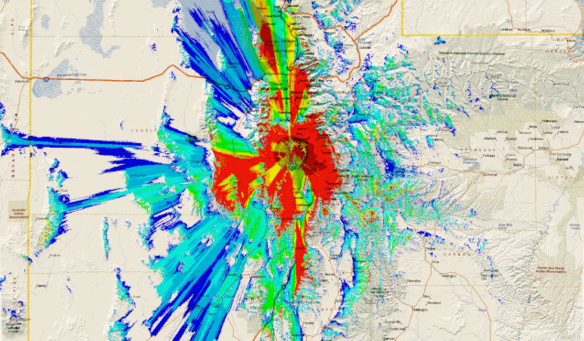 This study analyzes the antenna pattern of the Utah Amateur Radio Club's 146.760 MHz repeater following antenna relocation in 1997. Noting degraded transmission toward the north, a customized signal mapping system using a Yaesu FT-817, GPS, and software was developed to log real-time signal data. Calibration techniques extended the radio's signal range, enabling precise field measurements. The method allowed continuous signal strength monitoring while driving, revealing anomalies in coverage likely due to tower modifications. Findings helped assess and visualize the antenna’s actual radiation pattern and highlighted environmental impact on signal distribution.