Search results
Query: prefix
Links: 58 | Categories: 2
-
 The website provides a free to download large Jpeg DXCC map with amateur radio prefixes and CQ zones. It is a valuable resource for radio amateurs looking to identify DX entities and zones for their operations.
 -
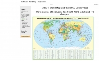
 Amateur radio world maps by VK2CA including DXCC list.
 -
 The page provides a tool to create a customized Ham Radio Az Map on the fly, with various dimensions available. It is a valuable resource for amateur radio operators to visualize and optimize pointing of directional antennas. The content includes maps for different regions, prefix maps, and world maps.
 -
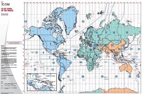 A 6 Mb PDF file of CQ Zones and ITU Zones and prefixes made available to download by Icom America.
 -
 AALog v3.9.0 Build 1288 is a Windows-compatible logging program for amateur radio operators, supporting Windows 2000 through Windows 10. It integrates with CwType, CwGet, TrueTTY, and AAVoice for CW, RTTY, PSK31, and voice operations. The software facilitates online and offline QSO entry, duplicate checking, antenna direction, and distance calculations to DX stations. Key features include managing multiple logs under a single callsign or for different callsigns, and extensive award tracking for DXCC, WAZ, P-75-P, WAS, WAJA, JCC, JCG, WAIP, Russia, RDA, DPF, DDFM, WAU, and WPX, with user-definable award additions. It includes a built-in QSL-manager database, locator grid support, and detailed prefix lists. The program supports export to ADIF and text files, and import from ADIF, LoTW reports, Cabrillo, and AATest formats. External database integration is supported for Buckmaster HamCall CD-ROM, QRZ CD-ROM, RAC CD-ROM (Flying Horse), and Russian Internet Callbook. QSL manager databases like GoList, QSL Routes, and WinQSL are also compatible. The software package for v3.9.0 Build 1288 is 10,630,589 bytes.
 -
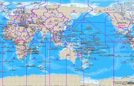
 A large jpeg DX World map that include ITU Zones, grid squares and prefixes. This high-resolution DX World Map is an essential tool for amateur radio operators. It clearly displays ITU zones, CQ zones, grid squares (Maidenhead Locator), and DXCC prefixes, helping you to plan QSOs, track propagation paths, and participate in global contests. Whether you are a seasoned DXer or a beginner, this map provides a clear, detailed view of the radio world, improving your station's efficiency and geographic awareness. Available in JPEG format, it's perfect for display
 -
 Electronic World atlas for radio amateurs. DXCC and province prefixes, CQ and ITU Zones in the rectangular and azimuthal projections, continuous zoom and scrolling, Gray Line, city and island index, unique hierarchical prefix database. COM/OLE Automation for easy integration with 3-rd party programs.
 -
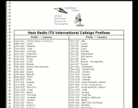
 Table of allocation of international Call Sign series
 -
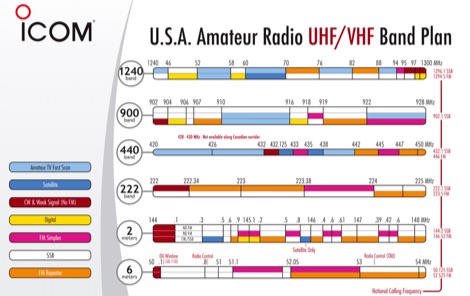 Download the PDF with USA Amateur radio HF band plan and common country prefixes updated in 2008 by Icom
 -
 A large collection of amateur radio maps, including CQ and ITU Zones, a complete set of ham radio Prefix Maps, grid locators and time zones map. An excellent ham radio mapping service.
 -
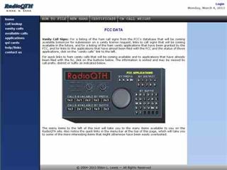
 For amateur radio operators seeking a specific call sign, RadioQTH offers a specialized online service to track FCC vanity license applications. The platform provides detailed listings of ham call signs from the FCC database, indicating those becoming available for vanity requests on specific dates. Users can access links to future availability, view recently granted vanity applications, and check the current status of applications already filed with the FCC. The data is sortable by call prefix, district, or suffix, facilitating a targeted search for desired call signs. This resource leverages real-time FCC data to assist hams in navigating the vanity call sign application process. It serves as a practical tool for predicting when a call sign might be obtainable, which is crucial for operators planning to upgrade or personalize their station identity. The site's functionality helps users monitor the progress of their own applications or identify potential call signs for future acquisition, streamlining a process that can otherwise be quite opaque.
 -
 Great shareware software collection for ham radio, includes prefix finders, locators,frequency generators and links to other ham radio software.
 -
 This web site represents the home of "Country Files", databases of entities (countries), prefixes and callsigns that are used by amateur radio logging software. There are three "flavors" of country files: CTY.DAT used by contest logging software such as CT, N1MM, NA, TR and Writelog DX4WIN.CTY used by the DX4WIN logging software WPXLOC.DAT used by packet cluster software such as AR-Cluster, CC Cluster and DX Spider maintained by Jim Reisert, AD1C
 -
 RadioQTH's Vanity Calls service provides a utility for US amateur radio operators to locate available vanity callsigns, specifically focusing on the shortest possible options. The system filters through all potential callsigns within a user's license class and presents only those currently unused, with results weighted by either their actual character length or their equivalent length in _Morse code_. This approach assists hams in securing memorable and efficient callsigns for CW operation. The service also lists recently granted vanity callsigns, sorted by prefix, offering insight into current FCC assignments. It clarifies the common misconception that callsigns are granted on a first-come, first-served basis, explaining the random selection process for applications received on the same day. The platform updates frequently, providing current data on available 1x2, 2x1, 2x2, 1x3, and 2x3 callsign formats, which are highly sought after by _Extra Class_ and _Advanced Class_ licensees.
 -
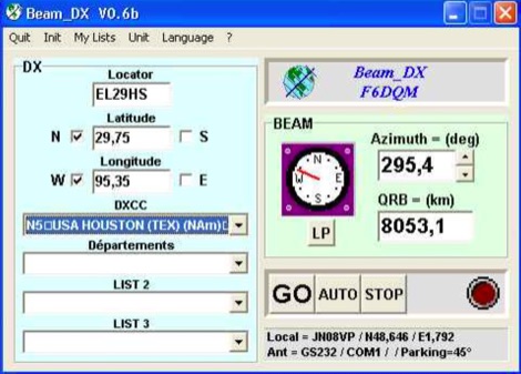 BEAM_DX is a free windows software for radioamateurs or radio listeners usage. It allows to point a directionnal antenna towards an azimuth, a locator, an international prefix or any other geographical position on earth predefined by its latitude and its longitude
 -
-
 ARRL web site International Call-Sign Prefix Allocations
 -
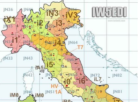 Map of italy with amateur radio prefixes and grid squares
 -
 Amateur Prefix Maps by UT0UM updated with ARRL DXCC and ITU changes, available for download in PDF
 -
 VQLog 3.1 - 782 is a shareware logbook program designed for Windows operating systems (95, 98, NT, 2000, ME, XP, Vista, 7, 10, or later), supporting resolutions of 800x600 or higher. It can also operate on macOS and Linux via virtualization software like Virtual PC for MAC, Oracle VirtualBox, or VMware. The software facilitates QSO access by date, callsign, prefix, square, DXCC, and other parameters, offering robust import capabilities for ADIF, Cabrillo, and ASCII files from various contest and logbook programs. Key features include comprehensive award tracking for DXCC, WAZ, WAC, WPX, WAS, IOTA, TPEA, DIE, VUCC, 100EACW, and up to 30 user-defined awards. It generates customizable summaries and graphical statistics for QSO activity, DX contests, Most Wanted Squares (MWS), propagation openings, and prefixes. VQLog supports DX-Spot reception and processing from DX-Cluster and PSK-Reporter with programmable warnings, integrates with callbook services like QRZ.COM and Buckmaster's CD, and offers online lookup. Electronic QSL and log upload support extends to LoTW, eQSL.cc, Clublog, and DXMAPS, with real-time updates for online logs. The program provides extended QSO information for VHF-DXers, including separate TX/RX frequencies, start/end times, propagation modes, and specific entry fields for MS, EME, and Tropo. CAT support for rig control and interfaces with ARSWIN and PstRotator for azimuth/elevation control are also included.
 -
 Russian callsign prefix series: RAA-RZZ, UAA-UIZ, includs Amateur callsign system in Russia
 -
 Over 47 full-screen maps are available within _NAOMI_ (North American Overlay Mapper), a free Windows program designed for US and Canadian amateur radio enthusiasts. This mapping suite includes 9 backgrounds such as CQ Zones, ITU Zones, and ARRL Sections, along with 16 foreground layers like Counties, Areacodes, and Grid Locators. Users can calculate distances and bearings, track real-time mouse positions with continuous Grid-Locator data, and integrate with APRS for live station tracking via the FindU database. For a global perspective, the _Global Overlay Mapper_ (GOM) provides a world map, 8 continental maps, and 29 sub-continental maps, all with 12 active layers including Country Outlines, CQ/ITU Zones, and Prefix information. Both NAOMI and GOM offer feature-locate systems to jump to positions based on prefixes, capital cities, or Grid Locators, and provide customized beam headings and distance displays. The site also features _LogView_, a post-contest log visualization tool that analyzes Cabrillo-format logs by plotting QSOs on maps, supporting over 30 major contests like CQWW and ARRL DX, and allowing comparison with published results.
 -
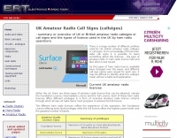 The UK amateur radio licensing scheme features three distinct tiers: Foundation, Intermediate, and Full, each granting specific operating privileges. For instance, the **Foundation Licence** permits a maximum of 10 watts output power on most allocated bands, with restricted band access. The Intermediate Licence allows up to 50 watts, while the **Full Licence** grants access to the maximum UK legal power limits and all available amateur radio band allocations. UK call sign prefixes and formats provide insights into the licensee's class and the approximate issuance date. For example, M3, M6, and M7 prefixes with three letters denote Foundation Licences issued from 2002, 2008, and 2018 respectively. Intermediate Licences, often starting with "2E0" or "2E1" followed by three letters, were issued from 1991 onwards. Full Licences encompass a broader range of prefixes like G2, G3, G4, G0, and M0, with varying letter counts indicating different historical license classes and issuance periods, such as G3 plus three letters issued between 1946 and 1971. Special prefixes like GB are reserved for repeaters, beacons, data mailboxes, and special event stations, with specific numerical sequences (e.g., GB3 for repeaters, GB7 for data repeaters/mailboxes) indicating their function. Optional prefixes such as GC, GD, GI, GM, and GW denote specific UK countries (e.g., Wales, Isle of Man, Northern Ireland, Scotland, England) and can also signify club stations.
 -
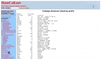 The HamCall.net database offers a detailed listing of amateur radio callsign divisions, organized by prefix, which is crucial for DXers and contesters to quickly identify the geographical origin of a station. Each entry includes a specific callsign prefix, the total count of callsigns registered under that prefix, and the associated DXCC country or entity, such as "AL9Z 43203 USA" or "3AOH9MM 237 MONACO." This structured data allows operators to rapidly ascertain the DXCC entity for a given callsign, aiding in QSL verification and award tracking. This information is particularly useful for confirming rare DX entities during contests or for logging contacts for awards like DXCC. For example, an operator hearing a "3Y0C" callsign can immediately identify it as Bouvet Island, a highly sought-after entity. The inclusion of callsign counts provides a sense of the activity level within each prefix, which can be helpful for anticipating pile-ups or assessing the likelihood of making a contact. The data presented reflects a snapshot of the HamCall database, offering practical insights into global amateur radio demographics.
 -
-

-
-
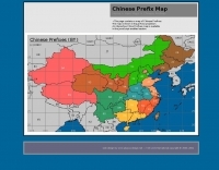
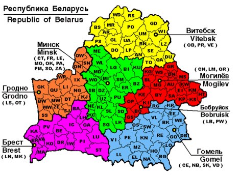
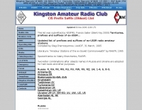
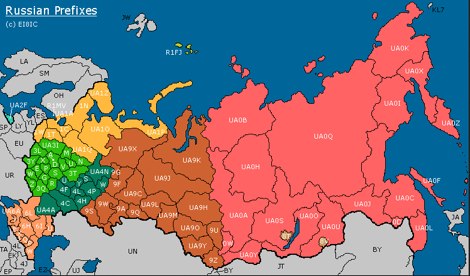 This page contains a map of Amateur Radio Russian Prefixes.
 -
 This large, colorful wall map features current geographic detail and labels, grid squares, call sign prefixes, boundaries and more.
 -
-
-
 For radio amateurs seeking to identify or verify callsigns from Bosnia and Herzegovina, an online callbook service offers a direct search utility. This resource focuses exclusively on the _T9_ prefix, allowing users to input a specific callsign and query a dedicated database. It serves as a historical reference for contacts made prior to its last update. The utility provides a straightforward interface for callsign lookups, presenting results based on data compiled up to _July 31, 2000_. While the information is static and not current, it remains useful for confirming older contacts or for historical research within the amateur radio community. The service is maintained by _Boris Knezovic, T93Y_, offering a focused resource for this specific geographic region.
 -
-
 RSGB World Prefix Map - Radio Amateur's Map of the World
 -
 For radio amateurs seeking to verify contacts or identify stations from Tajikistan, the _Tajikistan EY Callbook_ serves as a dedicated online resource. This callbook, compiled and maintained by Irage M. Tursoon-Zadeh, _EY8WW_, offers a focused database of callsigns within the EY prefix region. It provides a practical utility for DXers and contesters aiming to confirm QSLs or prepare for operations involving stations in this specific geographic area, streamlining the process of identifying active hams. The resource's utility is particularly evident for those engaged in award programs like _DXCC_ or _WAZ_ where accurate callsign verification is crucial for credit. Unlike broader, worldwide callbooks, this specialized listing ensures high relevance and accuracy for its target region, reflecting the local expertise of EY8WW. Its direct focus on Tajikistan makes it a valuable, albeit niche, tool for operators with specific interest in Central Asian DX.
 -
 Almost everything on the Italian ham-radio callsign assignment system
 -
 This program combines the formerly know programs PreFind and MU-Locator into one but with many improvements to find the location of any prefix, country or Maidenhead locator! Display and find locators on any map and calculate the distance and direction between two locators.
 -
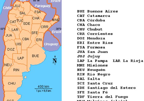 LU Argentina Country CALL division Antarctic and South Atlantic prefixes and sufixes
 -
-
 QSL gallery mostly for the deleted countries, old prefix, Antarctic stations and also for the very old cards prior 1945
 -
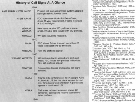 QST article from May 1994 about history of call signs from the very beginning to present system. Article explains call sign allocations, call areas, prefixes for novices and prefixes like K WA WB WD, callsigns during and after the world war II and other curiosities on US Call signs.
 -
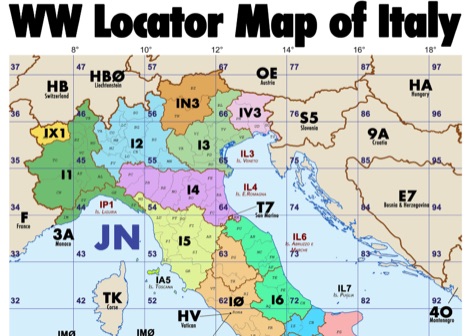 Amateur radio map of Italy with WW locators, provinces abbreviations and Call sign Prefixes, in a A3 size PDF file free to download, made available by IU3KJL Davide
 -
 M5AML - SSTV, Aerials (antennas), SSTV, Rallies, UK prefixes
 -
 DX Maps provides a specialized map printing service, focusing on amateur radio applications such as world prefix maps and custom great circle projections. The platform allows radio operators to visualize propagation paths and DX entities relevant to their QTH and operational goals. This service supports the creation of high-quality, large-format maps tailored for shack display or operational planning. The service facilitates the generation of personalized maps, which can include specific callsign locations, beam headings, and other critical amateur radio data points. Users can specify parameters to create maps that aid in understanding global propagation conditions and optimizing antenna aiming for long-distance contacts. The UK-based operation ensures a localized service for European hams, with international shipping options available. DX Maps also offers QSL card printing, complementing its mapping services.
 -
-
-
 Findu lookup interface, by station, position and prefix, Wap interface is availbale
 -
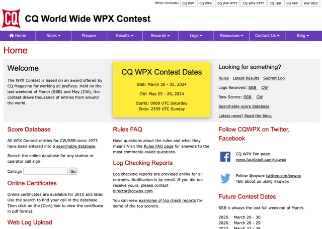 The CQ WPX Contest website provides information about the international contest based on working all prefixes, with details on dates, rules, results, log submissions, online certificates, and log checking reports. Users can also access a searchable score database, rules FAQ, and follow updates on the blog and social media. The site is a valuable resource for amateur radio operators participating in the WPX Contest.
 -
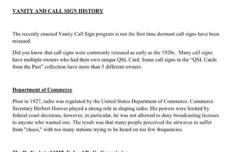 This resource provides a historical analysis of amateur radio call sign assignment policies in the United States, detailing regulatory shifts from the Department of Commerce to the Federal Radio Commission (FRC) and subsequently the Federal Communications Commission (FCC). It documents the evolution of call sign issuance, from early reissuance practices in the 1920s to the implementation of the Group Call Sign Assignment System on March 24, 1978. This system categorized call signs (e.g., 1x2, 2x1, 1x3, 2x3 formats) into groups A, B, C, and D, correlating with license classes such as Extra, Advanced, General, and Novice, and specifying prefixes for contiguous U.S. and territorial areas (e.g., _AH_, _KP_, _KL_). The document further details the legislative process leading to the modern Vanity Call Sign program, initiated by a petition in June 1990 and formalized by the Omnibus Budget Reconciliation Act of August 10, 1993. It outlines the FCC's adoption of final rules on December 23, 1994, and the subsequent fee structure, with the first vanity call sign issued on May 31, 1996, at a cost of **$30.00** for a ten-year term. The ARRL's proposed "starting gates" implementation strategy is also described, which phased in eligibility for vanity call signs based on license class and prior holder status. DXZone Focus: Historical Document | Regulatory Analysis | Call Sign Formats | Fee Structure
 -
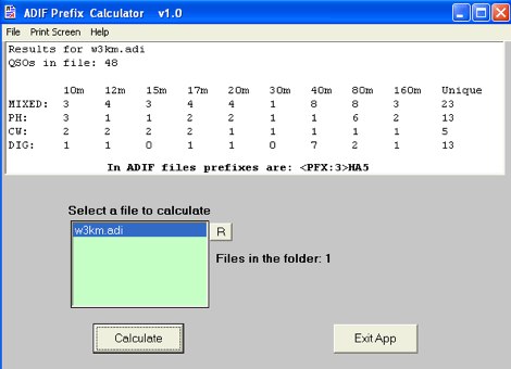 This software loads WPX type ADIF files with the <PFX:xxx> tag and calculates the different callsign prefixes. The software will load and capture the totals for big files. ADIF files must have the .adi file extension.