Search results
Query: adif to map
Links: 26 | Categories: 0
-
 Amateur Contact Log (AC Log) by N3FJP is a commercial Windows-based general logging program designed for amateur radio operators, supporting Windows 7 through 11. It provides comprehensive tracking for various operating awards, including Worked All States (WAS), Worked All Counties, Worked All Countries (WAC), DXCC, VUCC, Grids, Zones, IOTAs, and Lighthouses. The software features a customizable user interface, allowing operators to display specific data fields and adjust font sizes. It includes built-in databases for counties and countries, facilitates queries by band, mode, or power level, and offers a bearing and distance calculator for DX contacts. AC Log also provides DX spotting via Telnet or packet TNC, supports keyboard CW, and can play wave files. The program offers full support for ADIF import and export, enabling seamless integration with external services like eQSL, QRZ, Club Log, and the ARRL's Logbook of the World (LoTW) for QSO uploads and confirmation downloads. It interfaces with popular transceivers from Elecraft, Icom, Kenwood, Ten Tec, and Yaesu, and connects with digital mode software such as WSJT-X, Fldigi, and JTAlert via API. AC Log includes a Net Manager form for group logging, prints basic QSL label strips, and integrates with QRZ and Ham Call lookup services. The software is fully networkable for multi-PC operation, supports Parks on the Air (POTA) logging, and displays worked entities and DX spots on a real-time world map. Full featured Trial version available for 45 days
 -
 Demonstrates BBLogger, a **freeware** logging application designed for both amateur radio operators and Short Wave Listeners (SWLs). Developed by IK2VIW, IZ2BKT, and IK2UVR, this software provides comprehensive station management capabilities, including **CAT control** for various transceivers, integration with digital mode software like WSJT-X, JTDX, and MSHV, and robust QSL management features. The application supports a wide array of functions such as DX cluster interfacing, mapping, awards tracking (including custom awards), and direct integration with services like LoTW, eQSL.cc, and ClubLog for QSL confirmations and OQRS requests. It also includes utilities for ADIF to CSV conversion and vice-versa, catering to diverse logging and data management needs. Recent updates, such as version 13.1, introduce a web server for log management from any device, allowing remote access and control. The software has improved ADIF import capabilities, including time settings for duplicate QSO detection, and enhanced filtering options for log searches. Performance improvements include faster automatic updates and manager database synchronization, along with optimized log checking at startup. Earlier versions added support for FT8 and FT4 modes, refined OQRS integration with ClubLog, and expanded QSL/label printing functionalities, enabling users to select specific callsign types (OM, SWL) for printing. The developers emphasize compatibility with Windows 10/11 for full functionality, noting limitations when running on older operating systems like Windows 7 due to modern security protocol requirements.
 -
 Converts your logs into ADIF (Shacklog, EasyLog, PC-Profilog, LogPlus, DXLog, Log-Projekt, QW, UKWTEST, DAS LOG, HAM-LCT, Eurowinlog, StationMaster, Catlog, ARMAP95/98/2000, SPRINT, WinFD32, WAG, Fivenine, Excel Spreadsheet, CSV or TXT file; also ADIF to ASCII, import into RXCLUS DXCC and IOTA database, *.upf import file for IOTAMEM2 and many other features)
 -
 Demonstrates a comprehensive logging and contest program for Windows, _UCXLog_, designed to assist amateur radio operators in managing their QSO records and participating in competitive events. It integrates essential features such as transceiver control for single-operator two-radio (_SO2R_) setups, CW keying via COM/LPT ports, and SSB/RTTY operation through soundcard interfaces. The software also provides DX cluster connectivity via packet, internet, or Telnet, alongside robust statistics tracking for awards like _DXCC_ and _IOTA_, locator management, and greyline map display. Enables operators to efficiently handle log import/export functions, print QSL cards, and maintain detailed records of their contacts. The program's network capability facilitates multi-operator environments, while its support for various digital modes and rig control protocols enhances operational flexibility. Regular updates, including beta versions, are provided, ensuring ongoing development and feature enhancements for the amateur radio community.
 -
 A web site offering a QRZ.com integrated mapping service. Allows creating a google map of your QSOs adding a list of QSOs manually or importing an ADIF log file. Registration and a QRZ.com account is required.
 -
 Managing extensive amateur radio contact logs efficiently requires specialized software that integrates various operational aspects. Aether provides a macOS-native logging solution, designed from the ground up using Apple's Cocoa, to streamline QSO entry, organization, and retrieval for Mac users. It supports modern macOS technologies and offers an intuitive interface, aligning with the user experience expected on Apple platforms. The application includes features such as automatic dupe checking, which quickly identifies previous contacts with a station, and awards tracking, indicating if a new contact is needed for specific operating awards. Aether also integrates rig control via RS-232, automatically populating frequency, mode, and power data from supported Elecraft, Icom, Kenwood, Yaesu, and some TEN-TEC transceivers. This automation reduces manual entry errors and speeds up the logging process. Furthermore, Aether offers comprehensive QSL management, including synchronization with eQSL.cc and Logbook of The World, and the ability to print QSO detail and address labels for paper QSLs. It also incorporates automatic callbook lookup from sources like QRZ.com and HamQTH.com, and calculates distance and beam heading, with Google Maps integration for visualizing contact locations. Full ADIF and Cabrillo import/export capabilities ensure compatibility with other logging software and contest submission platforms.
 -
 VQLog 3.1 - 782 is a shareware logbook program designed for Windows operating systems (95, 98, NT, 2000, ME, XP, Vista, 7, 10, or later), supporting resolutions of 800x600 or higher. It can also operate on macOS and Linux via virtualization software like Virtual PC for MAC, Oracle VirtualBox, or VMware. The software facilitates QSO access by date, callsign, prefix, square, DXCC, and other parameters, offering robust import capabilities for ADIF, Cabrillo, and ASCII files from various contest and logbook programs. Key features include comprehensive award tracking for DXCC, WAZ, WAC, WPX, WAS, IOTA, TPEA, DIE, VUCC, 100EACW, and up to 30 user-defined awards. It generates customizable summaries and graphical statistics for QSO activity, DX contests, Most Wanted Squares (MWS), propagation openings, and prefixes. VQLog supports DX-Spot reception and processing from DX-Cluster and PSK-Reporter with programmable warnings, integrates with callbook services like QRZ.COM and Buckmaster's CD, and offers online lookup. Electronic QSL and log upload support extends to LoTW, eQSL.cc, Clublog, and DXMAPS, with real-time updates for online logs. The program provides extended QSO information for VHF-DXers, including separate TX/RX frequencies, start/end times, propagation modes, and specific entry fields for MS, EME, and Tropo. CAT support for rig control and interfaces with ARSWIN and PstRotator for azimuth/elevation control are also included.
 -
 Displays amateur radio grid squares worked from third-party logging programs, providing a visual representation of contacts on a world map. This Windows application uses colors to differentiate up to four bands concurrently, calculating the total number of grid squares worked per band. It reads plain-text log files, including fixed-width, character-delimited, ADIF, and Cabrillo formats, dynamically updating the map as log files are saved during contests or general operation. Primarily targeting **VHF** and above operators, WorkedGrids aids in grid square collection for contesting and awards. The software offers a fixed-resolution continental viewpoint, zoom-in capabilities, and supports printing or copying the map to the clipboard. It operates on Windows 95 through Windows 11, requiring minimal CPU and RAM, and features a non-invasive installation. The program has undergone several updates, with version 7 released on March 3, 2024, addressing minor fixes and improving stability.
 -
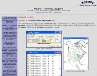 Demonstrates the _SQUIRL Field Day Logger_, a specialized software tool designed for efficient contact logging during the annual ARRL Field Day event. The resource details its core functionality, which includes real-time logging to easily readable text files, with filenames structured by callsign, band, and mode (e.g., K8DAA-20M-SSB.txt). It highlights features such as a real-time history grid of previous contacts, a dynamic USA and Canada map displaying contact locations, and a duplicate checker that provides audio notifications and pre-fills class/section data for previously worked stations. The software also includes an ADIF export function, enabling users to transfer logs to other general-purpose logging programs. The software's design emphasizes simplicity and ease of use, allowing for rapid on-the-spot training, as noted by users like W4CMB. It supports various operating systems, including Windows 98 through 8, and has been successfully run on Linux via _Wine_. Key usability enhancements include a "double-size" feature for improved readability and a "Space Mode" for quick field navigation. The version history indicates continuous development from 2001 to 2013, with significant additions like the real-time Field Day Map in 2003 and ADIF export in 2004, which allows for seamless integration with other logging platforms.
 -
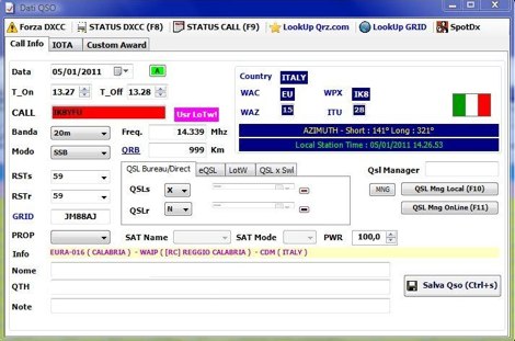
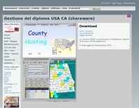 The County Hunting software, version **6.1**, is designed for amateur radio operators focused on USA-CA Award tracking and logging. This application supports _Windows_ environments and facilitates the import and export of ADIF files, enhancing QSL management by integrating electronic confirmations via LoTW and e-QSL. The software has been updated to align with the new award rules managed by MARAC, following the discontinuation of CQ magazine's involvement. Users can visualize QSLs post-scanning and benefit from enhanced ADIF import functionality. Version 5.4 introduced accelerated county searches via FCC databases, with filters for QSL confirmations and e-QSL enhancements. The software also includes a feature for backing up and restoring QSOs by LoTW confirmations. Visual County tools have been refined, offering improved map interactions and the addition of county flags. The software supports various digital modes including FT8, FT4, and SSTV, and includes functionality for PSK250 and 60m bands. The application is multilingual, with support for Italian, English, French, and Spanish, and provides automated updates and web-based county searches. DXZone Focus: County Hunting | ADIF | Windows | LoTW
 -
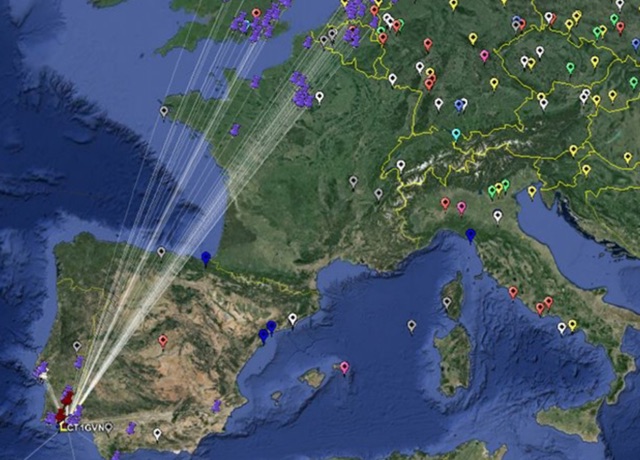
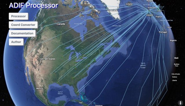 The ADIF Processor is an online application that visualizes amateur radio contacts from an ADIF log file using Google Earth. SOTA CSV log files can also be used. As well as allowing you to view and explore your contacts in Google Earth, you will be able to see a Markdown or text table of contacts, use the output ADIF file which contains QRZ.com data, accurate contact distances and fields populated from comments in the input file. Print QSL labels. One of the benefits of using the ADIF Processor before uploading/storing your ADIF file is detecting errors in callsigns and activity references (e.g. POTA or SOTA references).
 -
 Upload an ADIF fiel and plot all worked grids in an online map. Support filtering by band, year and can export the output directly into a google map, or a google earth KML file
 -
 Mircules HAM QuickLog provides a mobile logging solution for amateur radio operators, supporting quick contact entry on iOS and Android platforms. It features multiple log file management, instant callsign information display including Country, ITU zone, CQ Zone, and DXCC number, and robust ADIF and CSV import/export capabilities. The application is designed for efficient logging with optional fields and default values, streamlining the process for both shack and field operations. The software includes dedicated support for POTA, SOTA, and IOTA activations through specific fields like MY_SIG_INFO, SIG_INFO, MY_SOTA_REF, IOTA, and MY_IOTA. A specialized contest mode offers real-time dupe checking and automatic TX exchange updates to enhance contest efficiency. Integration with QRZ.COM and HAMQTH.COM allows for direct operator information lookup and import, while Open Street Maps integration provides geographic context for contacts. The application also features a notes and scratchpad function for each log file.
 -
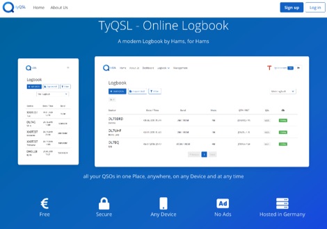 TyQSL provides a web-based online logbook platform, enabling users to manage all QSOs from any device with features like fast ADIF import, supporting up to **100,000 QSOs** per file. The platform facilitates real-time uploads to services such as _Clublog_ and _eQSL_, either automatically or with a single click, ensuring logs are current across multiple platforms. Operators can manage multiple callsigns and create various logbooks within a single account, allowing for flexible QSO organization. The integrated logger features a streamlined layout with live DXCC checking, duplicate QSO alerts, and autofill for satellite operations. It also supports one-click logging from _WSJT-X_. Users can share public profiles, displaying QSO statistics and searchable logbooks, enhancing community interaction. A PRO account offers additional features like an interactive QSO map, showing worked grids and future activities of other users.
 -
 This freeware application for Linux and windows, allows you to convert an ADIF file to a KML file so you can map your QSOs easily and open it with google maps, or google earth or any application supporting the KML format
 -
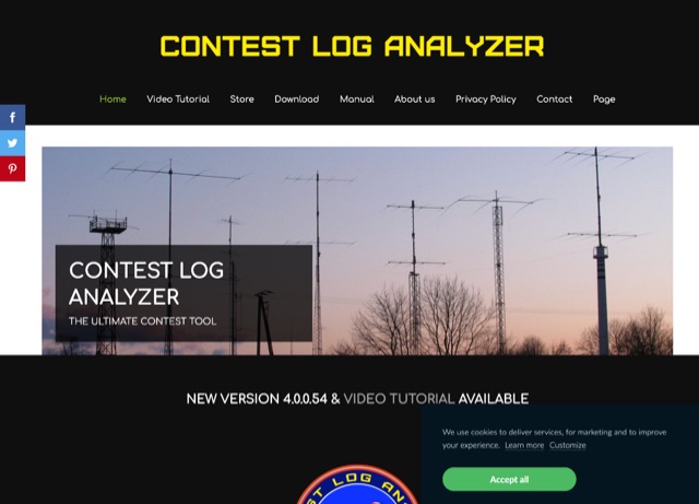 The complete software suite to Edit, Analyze, Generate Statistics, View multiple logs simultaneously, Map QSOs, Import and Export to Cabrillo or ADIF files. The Contest Log Analyzer has been developed as a complete database management application, where you can create separate Databases, containing several Logs, a convenient way to save, in one place only, all your log files that accumulate over the years. It runs on Mac and Windows, and it is a commercial product.
 -
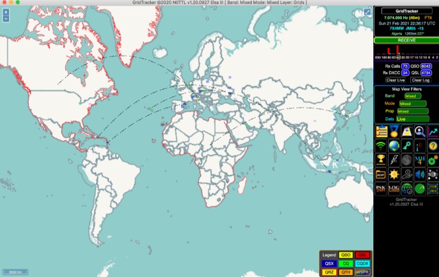 GridTracker listens to live traffic from WSJT-X or JTDX and displays it on a map. It can also load ADIF log files, load clublog, lotw, hrdlog.net and other sources to diplay your logbook statistics and map your QSOs. GridTracker is a free application for windows Linux and MacOS.
 -
 Time Mapper UHD is a versatile mapping and time visualization program offering multi-satellite viewing with frequency display and unique country-pairs for PskReporter data. It features live feeds from logging programs and can plot ADIF files. Ideal for schools, offices, or amateur radio stations, it provides customizable 4K or HD world clock displays with over 60 map layers, including ham radio zones and natural features. The program supports various time functions and can import logs for detailed analysis. It runs on Windows 10 or 11 and offers a 30-day free trial.
 -
 First released in 1988, _SWLog_ is a comprehensive suite of applications providing logging and remote control for both amateur radio and shortwave, utility, and broadcast listening. It integrates program schedules from sources like _HFCC_, _ILGRadio_, and _EiBi_ for broadcast reception, while also linking with amateur radio logbooks such as _ClubLog_, _eQSL_, _QRZ_, and _LoTW_. The software supports radio control for various transceivers, including _Flex_, Icom, Yaesu, and Kenwood, alongside interfaces like _FLRig_, _OmniRig_, and _HamLib_. Mobile applications for Android and iOS facilitate on-the-go logging and remote control, seamlessly transferring logs without manual ADIF export. _SWLog_ leverages an enterprise-grade relational database (SQL Server) for robust data management and analytics, enabling features like mapping QSOs by band or state. It offers specific integrations for _POTA_ monitoring, displaying active spots with real-time propagation and automatic radio tuning. The application's scalability allows multiple users to log to a centralized database, suitable for Field Day or DXpeditions. The user interface features modern aesthetics with light, dark, and gray themes, the latter optimized for outdoor visibility during activities like _POTA_ or _SOTA_. The Plus Edition, available for an annual fee, expands capabilities with advanced QSL integration, additional map providers, and enhanced propagation calculations using _VOACAP_.
 -
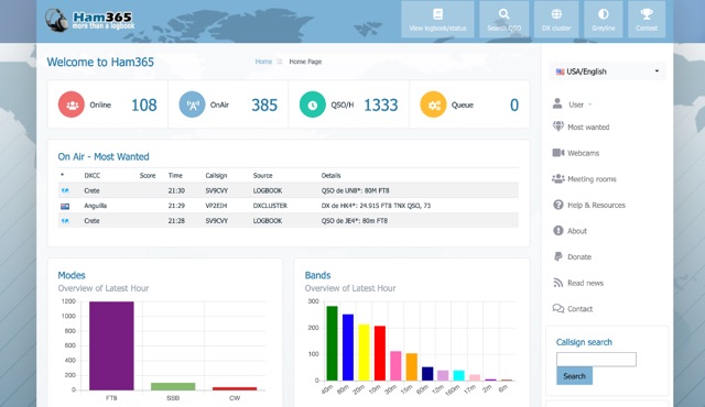 Over 15 years of continuous operation, Ham365 provides a web-based logging solution for Amateur Radio Operators, allowing them to maintain and share their QSO records online. Originally launched as the online logbook component of Ham Radio Deluxe, it has since evolved into an independent platform, now integrating with numerous other logging applications. The platform shares its database with HRDLOG.net, ensuring that operations performed on one site are reflected on the other, maintaining data consistency for users. Key features include an overview of the latest hour's activity, a display of the most recent QSOs, and a map visualizing recent contacts. It also highlights "Most Wanted" entities and ongoing DXpeditions, providing a dynamic view of current amateur radio activity. The logbook supports various operating modes, including SSB, RTTY, PSK31, and FT8, and handles ADIF data for interoperability. Users can manage their logbooks, track DX activity, and utilize features like OQRS (Online QSL Request System) through its integrated functionalities. The system is designed to be accessible to a wide range of operators, from casual ragchewers to avid DXers and contesters.
 -
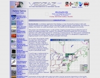
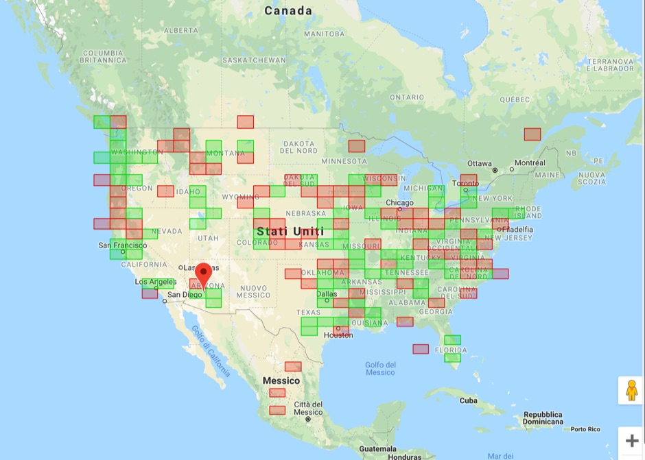
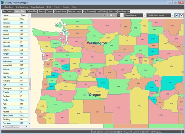 A unique, easy-to-use Amateur Radio program for creating County, State, Section and Grid Locator outline maps of North America that can be filled by Hand, from a Contest Logger UDP Feed, or from Imported ADIF or Cabrillo Logs.
 -
 Hamradio_copilot is an open-source tool designed for DXers and contesters who need real-time situational awareness. It is ideal for operators who want to visualize propagation trends instantly rather than scrolling through raw text streams of cluster spots. Rally acting as a copilot for your station, this tool transforms raw data into actionable intelligence. By visualizing Signal-to-Noise Ratios (SNR) across different bands, it helps operators make quick decisions on which band to prioritize or where to point their antennas, effectively showing not just who is on air, but where the propagation is currently open from your location. This is a fantastic information for avid contesters. The software aggregates data from two primary services: - Reverse Beacon Network (RBN) via Telnet. - PSK Reporter via MQTT feeds. It processes this data to generate a comprehensive HTML report featuring SNR heatmaps and statistical breakdowns by ITU Zone. Users can filter data by specific zones or country codes (ADIF), analyze historic time ranges, and optionally integrate solar weather data. The complete source code is available on GitHub, allowing for community customization. It is written in Python and uses SQLite for data management.
 -
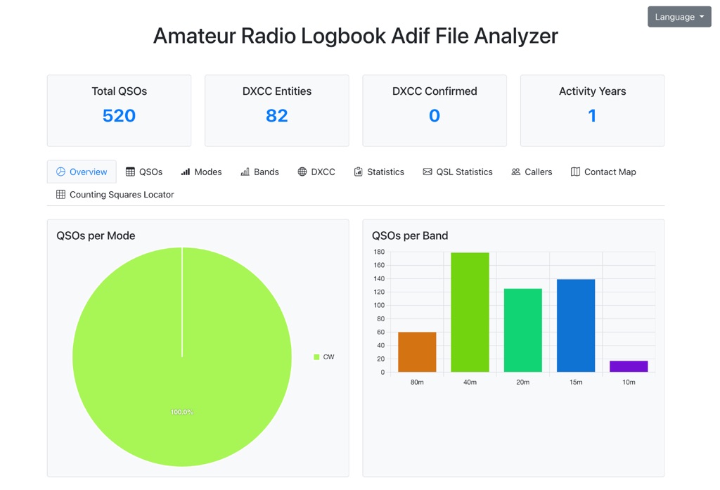 The Amateur Radio Logbook ADIF File Analyzer available at loganalyzer.sv5fri.eu is a convenient web-based tool that allows you to upload your ADIF log and instantly generate a visual map of your QSO contacts along with detailed statistics—by band, mode, time, grid squares, DXCC, and more. It provides an intuitive overview of your operating patterns and performance without requiring any software installation.
 -
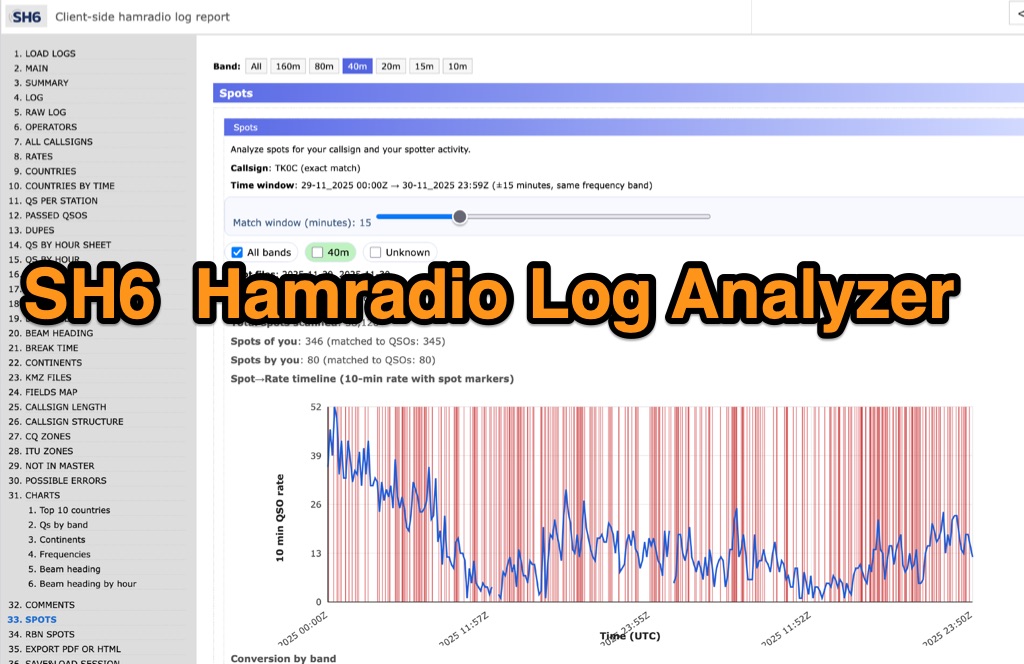 SH6 is a versatile, browser-based utility designed for the detailed analysis and visualization of amateur radio contest logs. Supporting standard formats such as Cabrillo and ADIF, the tool allows operators to upload personal files via drag-and-drop or access a searchable public archive containing over one million logs. Key capabilities include comprehensive performance metrics, offering summaries of band breakdowns, QSO rates, and beam headings. Furthermore, SH6 provides advanced geographic visualization through interactive maps, analyzing contacts by country, zone, and continent. A standout feature is the side-by-side comparison mode, enabling users to contrast two distinct logs for strategic assessment. SH6 transforms raw log data into actionable insights regarding operator performance without requiring software installation.
 -
 GridViewer is an interactive and lightweight open source web-based tool designed for ham radio operators to visualize and analyze their worked grid squares from ADIF-log files. GridViewer was developed to address a real-world challenge faced by many ham radio operators using lightweight or single-board computers like the Rock 4 SE (in my case) or Raspberry Pi.
 -
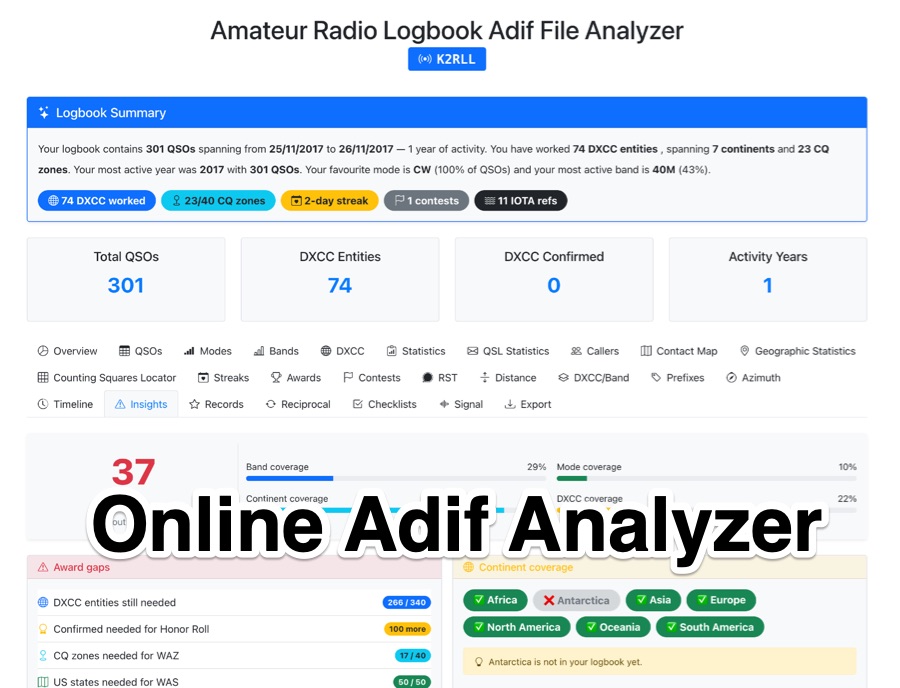 The _Amateur Radio Logbook ADIF File Analyzer_ processes ADIF files locally within the user's browser, ensuring no QSO data is uploaded to a server. It generates a visual map of contacts and detailed statistics across various parameters, including band, mode, time, grid squares, and DXCC entities. The tool offers insights into operating patterns and station performance without requiring any software installation. Users upload their ADIF log files directly, and the analysis is performed client-side, providing immediate results. The output includes charts and graphs that visualize QSO distribution and activity. This approach prioritizes user privacy and data security, as logbook information remains on the user's computer throughout the analysis process. The analyzer supports standard ADIF formats, enabling hams to quickly review their log data for trends and achievements. It is a free, open-source utility designed for general amateur radio log analysis.