Search results
Query: forecast
Links: 33 | Categories: 4
-
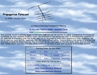
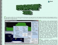 DXprop is a radiowave propagation forecast freeware for ham radio operators, permits to predict propagation on 12 frequencies. Use Minimuf 3.5 routine developped for US Navy. Available in French and English
 -
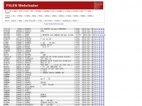
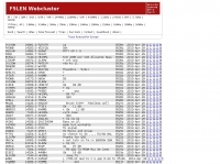 Presents a web-based DX cluster interface, F5LEN Webcluster, which functions as a member node within the broader European DX Cluster network. It displays current DX spots across a wide range of amateur radio bands, from VLF through SHF, including specific bands like 1.8 MHz, 144 MHz, and 10 GHz, as well as satellite operations on QO-100. The service offers filtering options for various modes and activities, such as CW, QRP, IOTA, and specific VHF/UHF bands. Operators can access real-time propagation data, including Solar Flux Index (SFI), Sunspot Number (SSN), Kp index, and Auroral activity (Au), alongside tools for solar forecasts and tropospheric ducting predictions. The platform facilitates DX spotting by providing a centralized point for sharing and viewing contact information, aiding in DX hunting and contest operations. It also includes links to an Atlas, Sun tools, and a mobile version for portable access.
 -
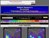 William Hepburn's Daily Tropospheric Ducting Forecast.
 -
 DXMaps.com presents a dynamic, real-time mapping service for amateur radio DX spots, integrating data from traditional DX clusters, _PSK Reporter_, and WSPR networks. The platform visually plots global QSO and SWL activity, enabling users to observe propagation conditions across various bands, from 2200m to >450 MHz. It offers distinct overlays such as the magnetic equator, gray line, moon footprint for EME, and VOACAP propagation predictions, providing a comprehensive view of radio wave behavior. The service allows granular filtering of displayed spots, including options to show only DX-Cluster data, PSK Reporter activity, or WSPR signals. Users can refine the map view by selecting specific bands (e.g., 160m, 20m, 6m, 2m), limiting spots to the last 15 minutes, or displaying only contacts exceeding **2600 km**. Additional features include the ability to toggle grid squares, aurora forecasts, and various amateur radio zones (CQ, ITU). Distinctively, the resource updates automatically every minute, ensuring current propagation intelligence without manual refresh. It also supports specialized views for EME, ionospheric scatter, and aircraft scatter, alongside FM DX and APRS activity. The platform emphasizes the importance of accurate locator information in DX spots to enhance data quality and offers a user manual and FAQ for guidance.
 -
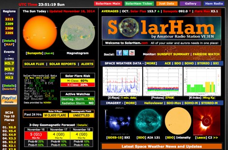 SolarHam is a website all about the Sun and how it affects Earth. This site is routinely updated with breaking news, sometimes hours before other Space News websites. You can trust SolarHam.com for the most up to date and accurate solar information on the net. SolarHam is a trusted and easy-to-use website for anyone interested in solar activity and space weather. It gives daily updates on <b>solar flares</b>, sunspots, geomagnetic storms, and radio blackouts. The site uses data from NOAA and NASA to show what is happening on the Sun and how it may affect radio signals on Earth. Charts and images are clear, and reports are updated often. Many amateur radio operators use SolarHam.net to check band conditions and aurora forecasts before operating. The site is fast, well organized, and focused on the needs of the radio community. Whether you are a beginner or an experienced ham, SolarHam.net is a helpful tool for understanding space weather and its impact on radio communications.
 -
 Approximately 400 kHz is the primary frequency for Navtex broadcasts, a crucial maritime safety information system. This legacy software, _Frisnit Navtex Decoder_ version 2.1.5, provides a means to decode these messages directly from an amateur radio receiver's audio output, fed into a PC's microphone input. It operates by processing the audio stream, extracting the FSK (Frequency Shift Keying) data, and presenting the decoded text on a Windows platform. Despite being unsupported and no longer under active development, the application remains functional across a wide range of Microsoft operating systems, from _Windows 95_ through _Windows 11_. Its utility lies in offering a straightforward, no-cost solution for hams and SWLs interested in monitoring Navtex transmissions without specialized hardware. The software's design focuses on simplicity, allowing users to quickly set up and begin decoding maritime weather forecasts, navigation warnings, and other safety-critical information. It leverages the PC's sound card, making it accessible with minimal additional equipment beyond a receiver capable of tuning to the Navtex frequencies.
 -
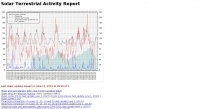
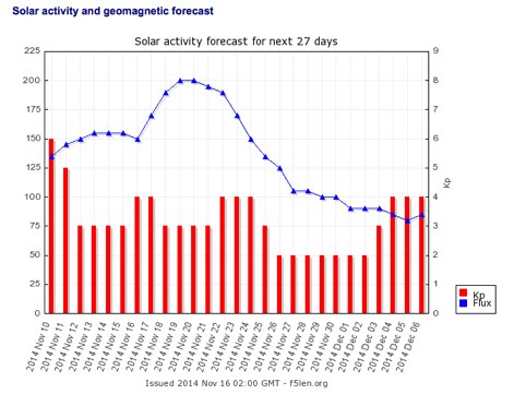 Display solar activity forecast for next 27 days, display A-index, Sunspot Numbers and Flux forecast including graphs for solar activity and geomagnetic forecast. All forecasts are updated daily.
 -
 Understanding high-frequency (HF) skywave propagation is crucial for amateur radio operators seeking to optimize long-distance communications. This resource details the fundamental principles of HF radio propagation, including the properties of electromagnetic waves, the characteristics of various HF bands, and distinct propagation modes such as skywave, ground wave, and line-of-sight. It places significant emphasis on the ionosphere's pivotal role in refracting HF waves, explaining how solar activity directly influences ionospheric conditions and, consequently, propagation paths. The resource integrates real-time monitoring capabilities, featuring dynamic charts and data from DX clusters, WSPRnet, and the Reverse Beacon Network, which allow users to track current band activity and propagation conditions globally. It also delves into advanced topics like Near Vertical Incidence Skywave (NVIS) and gray line propagation, providing insights into ionosonde data and various propagation prediction models. The site presents a detailed analysis of solar-terrestrial interactions, geomagnetic indices, and space weather phenomena, illustrating their direct impact on HF communication reliability. Practical tools and applications are highlighted, including real-time QSO planners, online Maximum Usable Frequency (MUF) maps, and alerts for solar flares or geomagnetic storms. The guide systematically breaks down complex concepts into accessible chapters, offering a structured approach to learning about ionospheric regions, diurnal and seasonal effects, and the interpretation of propagation indicators like foF2, MUF, and Lowest Usable Frequency (LUF). This makes it a robust reference for hams aiming to deepen their technical understanding and improve operational effectiveness.
 -
 The Deutscher Amateur-Radio-Club (DARC) e.V. serves as the largest association for radio amateurs in Germany and Europe, structured into 24 districts and approximately 960 local chapters nationwide. Its core mission involves fostering amateur radio and establishing favorable conditions for the Amateur Radio Service. The DARC actively participates in international affairs as a member of the **International Amateur Radio Union (IARU)**, ensuring German interests are represented on a global scale. Recent activities include the announcement of the FUNK.TAG in Kassel for April 25, 2026, and the HAMCamp at **HAM RADIO** in Friedrichshafen from June 26-28, 2026, offering discounted participation for young operators up to 27 years old. The club also supports special events, such as a short-term award and special callsign DB15ØWG to commemorate the 150th anniversary of the Weimar–Gera railway line, active from April 1 to June 30. Regular updates, like the Deutschland-Rundspruch 11/2026, cover topics from the status of 70 MHz band permissions to satellite deployments like Ten-Koh 2, and contest results such as the WWA YL event. Propagation forecasts, including Kp indices and solar flux values, are provided by Hartmut Büttig, DL1VDL, offering insights into HF conditions and Gray-Line DX opportunities. The DARC also reports on district elections and space-related events like the Bochumer Weltraumtag, highlighting the diverse engagement of its members.
 -
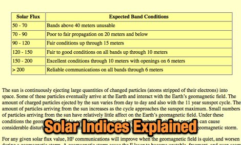 Comprehensive guide to understanding of solar indices, reading this article you will allow a better understanding and interpretation of propagation forecast bulletins and propagation reports
 -
 Propagation forecasting software for the Macintosh
 -
 Broadcast via WWV and WWVH at 18 and 45 minutes past the hour. This message is updated every 3 hours. Reports current Solar-terrestrial indinces, Solar Flux, A-index, K-Index, forecast for space weather storms. Prepared by the US Dept. of Commerce, NOAA, Space Environment Center
 -
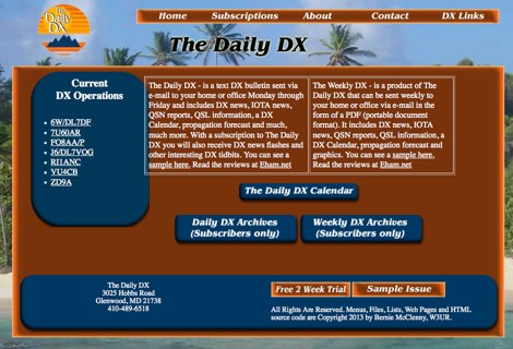 The Daily DX is a text DX bulletin sent via e-mail. To subscribe you have to pay for the daily or weekly subcription and you will receive DX news to your home or office by e-mail Monday through Friday, 50 weeks per year. Includes DX news, IOTA news, QSN reports, QSL information, a DX Calendar, propagation forecast and much, much more.
 -
 DX_Central, a compact desktop application, provides amateur radio operators with critical propagation data by aggregating solar statistics and imagery from various authoritative sources. This includes real-time information from agencies like NOAA and NIST, offering insights into current space weather conditions that directly impact HF propagation. The software is designed for both Linux and Windows operating systems, making it accessible to a broad range of hams. It presents a concise overview of solar activity, which is essential for planning DX operations and understanding band openings and closures across the HF spectrum. Operators can utilize the displayed solar flux index, K-index, and other relevant parameters to make informed decisions regarding their operating times and target bands, optimizing their chances for successful long-distance contacts.
 -
 11 Years of monthly propagation reports from February 1988 to January 1999 by AD5Q
 -
 The _ISS Detector_ Android application, with over 5 million downloads, offers precise predictions for visible passes of the International Space Station. It notifies users minutes before an overhead pass, integrating local weather conditions to ensure optimal viewing opportunities. The core functionality focuses on the ISS, but in-app purchases extend its capabilities to track other celestial and artificial objects. Optional extensions, available via in-app purchase, allow users to monitor dozens of amateur radio and weather satellites, providing real-time transmitter information and Doppler frequencies. Additional extensions cover _Starlink_ satellites, the _Hubble Space Telescope_, rocket stages, bright satellites, comets, and planets, expanding the scope beyond the ISS to a broader range of observable space phenomena. The app's interface is designed for ease of use, displaying pass times, directions, and elevation. It adapts predictions based on the user's GPS location, ensuring accurate local forecasts. The latest update, dated April 3, 2026, includes corrections for magnitude values and various speed and stability optimizations.
 -
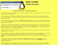 Several bash scripts are provided to automate common amateur radio tasks on Linux and FreeBSD systems, addressing the need for quick access to specific data without navigating web interfaces. These utilities include `call` for fetching US callsign details from callook.info, `qth` for obtaining address information for US and Canadian callsigns, and `grid` for determining grid squares based on license addresses. Each script is designed for command-line execution, allowing for single lookups or interactive sessions, and emphasizes a KISS (Keep It Simple, Stupid) programming philosophy. Another script, `au_kp.sh`, is tailored for weak signal VHF operators, fetching and displaying the NOAA 30-minute Aurora forecast and GFZ Space Weather Kp index data. This script generates static images, requiring re-execution for updates, and is intended to be run as a clickable desktop object for real-time space weather monitoring. It helps operators track propagation conditions, especially during solar cycle peaks. Beyond bash scripts, the resource offers a PHP/web page `fortune` implementation, including Henrik Aasted Sorensen's PHP script, sample HTML/CSS, and a HOWTO guide for creating fortune files. W3DHJ provides several amateur radio-themed fortune files, such as "Ham Humor & Wisdom" with 354 entries and "VHF Rover Humor & Wisdom" with 223 entries, along with other general humor and wisdom collections. These fortune files are designed with embedded HTML for web page display and are refreshed monthly, offering a total of 21,400 entries.
 -
 Solar data with current solar status, forecast and propagation report
 -
 Refractive Index maps forecast for Europe
 -
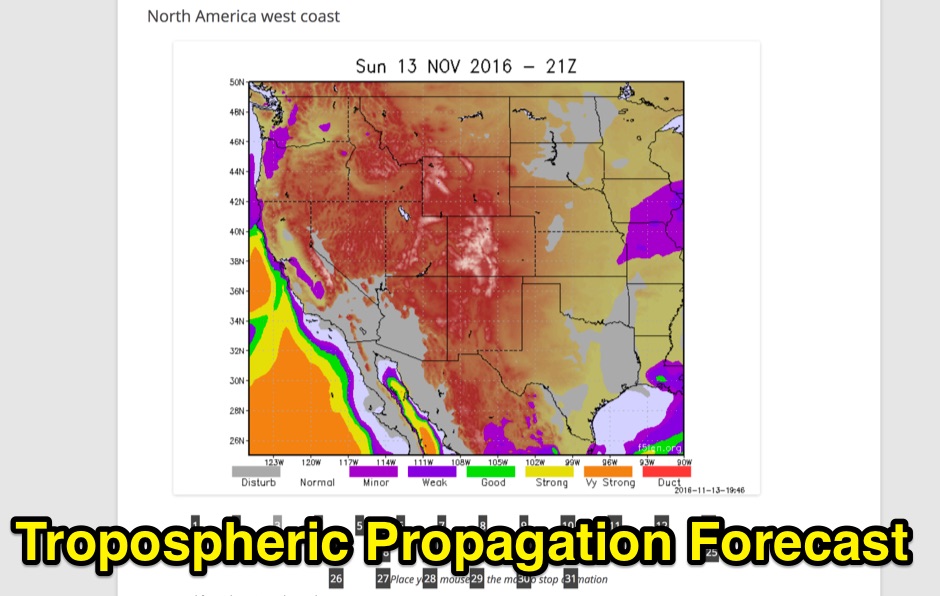 Tropospheric Propagation Forecast for several areas. Base on a computed refractive index 4 times a day.
 -
 Details the Highline Amateur Radio Club (HARC), an organization dedicated to public service through Amateur Radio and community engagement for radio enthusiasts. The club conducts a monthly general meeting on the 4th Saturday at 10 AM at Burien Fire Station 28. HARC also hosts a weekly net on Tuesdays at 7:30 PM, operating on **146.660 MHz** with a -600 kHz offset and a 103.5 Hz **CTCSS tone**. Additionally, members gather for a weekly breakfast on Fridays at 9:30 AM at Tuscany at Des Moines Creek. The resource provides current weather conditions for Burien, WA, displaying temperature, wind chill, and a three-day forecast from the National Weather Service Seattle/Tacoma Office. It also links to the latest ARRL Newsletter, noting a system breach in May 2024 affecting archived links. The club's activities include regular meetings, on-air nets, and social gatherings, supporting local amateur radio operations and community involvement.
 -
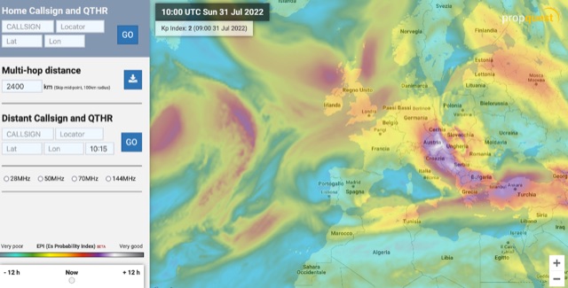 The map display allows you to select by locator, or clicking on the map, where you want to calculate the probability of Sporadic-E by building a combination EPI, Es Probability Index, based on factors using many of the known parameters which can effect Es. T
 -
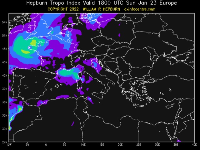 The areas noted in the forecast have the necessary atmospheric conditions to produce tropospheric bending of VHF, UHF and/or microwave radio waves. Tropospheric bending extends the range of radio & TV stations well beyond their normal limit and thus increases interference amongst stations as well.
 -
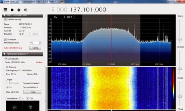 The Meteor-M N2 is a polar orbiting Russian weather satellite that was launched on July 8, 2014. Its main missions are weather forecasting, climate change monitoring, sea water monitoring/forecasting and space weather analysis/prediction. Meteor-M N2 transmits images using the digital LRPT protocol at around 137.1 MHz with can be received with an RTL-SDR.
 -
 Aurora forecast is updated daily at midnight UTC includes Kp Index forecast for next 3 days
 -
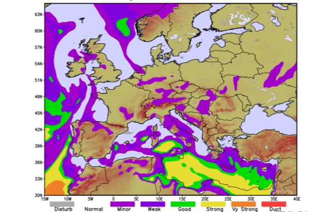 Forecasts for Europe and mediterranean sea
 -
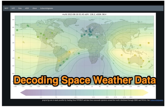 The article enlightens radio amateurs on utilizing real-time space weather data to optimize HF communication. Navigating through Hp30 index, MUF, f0F2, and eSFI metrics, it explains their significance in band selection and propagation forecasting. With essential links and practical insights, enthusiasts learn to discern optimal conditions for high-band DX, low-band DX, and NVIS operations. The author's observations and antenna optimization tips enrich understanding for effective HF operations.
 -
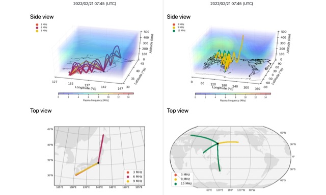 HF-START can estimate HF propagation between any given 2 points over Japan in real-time by using GNSS tomography, and can be used to forecast HF propagation 1 day in advance between any given 2 points globally by using GAIA model.
 -
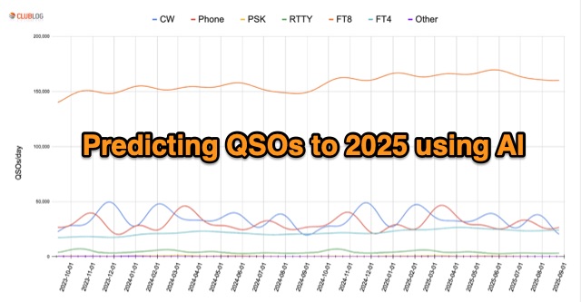 In an innovative analysis, Michael G7VJR employs NeuralProphet to predict ham radio modes' usage trends. The AI model, leveraging deep learning, forecasts a steady FT8 dominance, with slight declines in CW and Phone activities. This approach simplifies statistical predictions, showcasing the power of AI in understanding complex patterns and facilitating insightful time series projections. Access the freely available Club Log data for continuous exploration.
 -
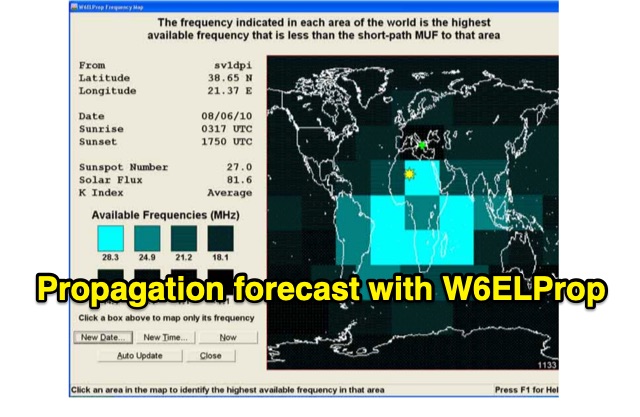 In 2004, Carl Luetzelschwab, K9LA, wrote a guide on using W6ELProp for radio wave propagation predictions. This tutorial, translated for broader accessibility, explains initial setup, configuration, and daily use. It emphasizes using mean solar index values for accuracy, helping users effectively predict and interpret propagation for improved amateur radio operations.
 -
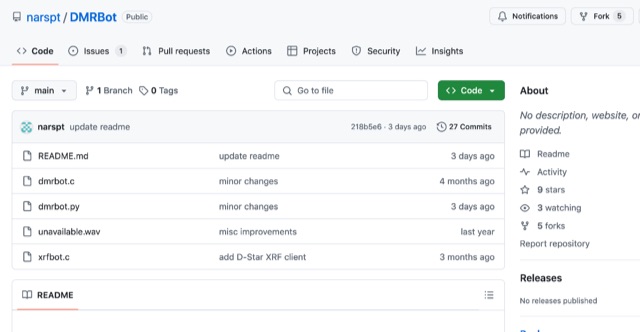 This software connects to a DMR master using the MMDVM protocol, enabling a ChatGPT-powered AI bot for voice interaction. It comprises a main program (a DMR/D-Star client handling audio via AMBEServer) and a Python script for audio processing via APIs. OpenAI Whisper handles speech recognition, while Google Translate powers text-to-speech, supporting multilingual interaction. Clear, polite questions improve recognition. If silent for over one second, the bot provides local weather, with forecasts available on request. English performs best for recognition accuracy.
 -
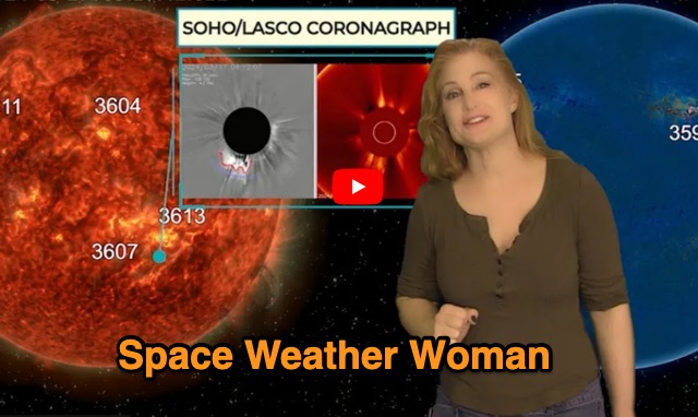 Website dedicated to weekly space weather forecast and updates on current solar activity. Dr Skov provides video forecasts and weekly audio forecasts
 -
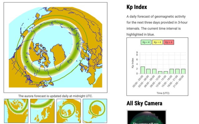
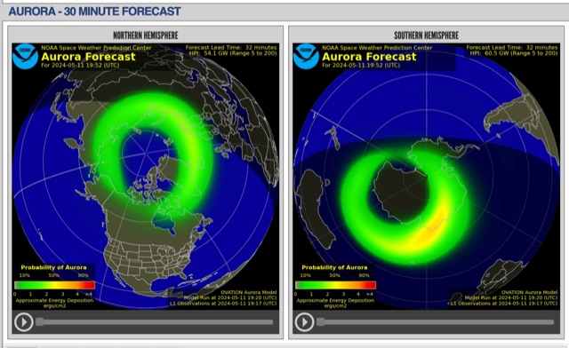 The short-term aurora forecast, based on the OVATION model, predicts aurora location and intensity 30 to 90 minutes ahead, aligning with solar wind travel time. Maps show aurora ovals in green, turning red for higher intensity. Aurora, visible after sunset or before sunrise, impacts technologies like radio communication, GPS, and power grids. It's a mesmerizing space weather spectacle, drawing travelers to the Arctic.