Search results
Query: tracking
Links: 184 | Categories: 13
Categories
- Software > Awards tracking
- Operating Modes > Satellites > Real Time Tracking
- Software > Satellite tracking
- Radio Scanning > Aeronautical
- Software > Antenna rotor control
- Software > Beacon Monitoring
- Software > D-STAR
- DX Resources > DXCC
- Software > EME
- Operating Modes > Ham Radio Balloons
- Operating Modes > International Space Station
- Software > Legacy Systems > PalmOS
- Radio Scanning > Weather
-
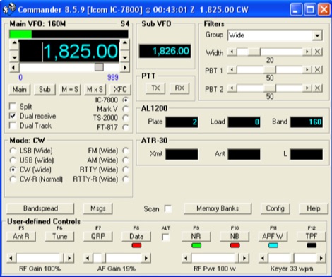 A free application that controls up to 4 Alinco, Elecraft, FlexRadio, Icom, JST, Kachina, Kenwood, TenTec, or Yaesu transceivers, switching between them manually or automatically based on frequency, and displaying frequency-dependent settings for devices like tuners and amplifiers; includes a bandspread, and supports transverters, frequency and mode tracking by an independent transceiver or receiver, SDR-based panadaptors, and SO2R switching with microHam or OTRSP-compliant devices.
 -
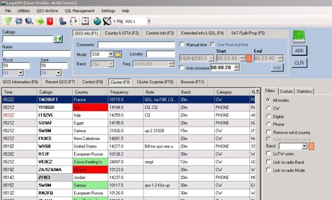
 Logger32 is a well-established amateur radio logging program designed primarily for DXers who require a flexible and data-driven logging environment. The software maintains a comprehensive logbook database capable of handling large volumes of QSOs while offering detailed tracking of DXCC entities, awards, and band/mode statistics. One of the core strengths of Logger32 is its DX cluster integration. The program connects to telnet DX clusters and displays spots in real time, with filtering options by band, mode, country, or callsign. The cluster window can automatically highlight needed DXCC entities, band-fills, or new modes based on the operator’s log. Logger32 also provides rig control through CAT interfaces, supporting a wide range of transceivers via serial or USB connections. When properly configured, frequency and mode are automatically captured in the log entry window. The software supports digital mode integration through external applications and can exchange information using standard interfaces. Another important feature is its award tracking system, including DXCC, WAS, IOTA and other common amateur radio awards. The program calculates worked, confirmed, and needed entities with detailed reports. Logger32 supports ADIF import and export, allowing interoperability with other logging systems. It also includes QSL management, with tracking for bureau, direct, and electronic confirmations such as LoTW or eQSL when configured. Overall, Logger32 remains a technically capable logging solution focused on DX tracking, cluster awareness, and detailed statistical analysis of operating activity.
 -
 Footprint Satellite Tracker is a satellite tracking software that provides real-time monitoring of satellite movements worldwide. It features a global map with celestial markers and allows users to adjust time settings to predict satellite paths. Customizable options include location coordinates and time zones. Users can analyze satellite ephemeris and print reports, though file-saving requires a virtual printer. Despite its research utility, the software supports a limited satellite list and lacks options for manual data source connections. Current version has been tested running on Windows 10.
 -
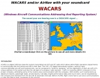 The only ACARS software to feature in-line message decoding and aircraft tracking. ACARS Reception and Decoding Software for legacy Windows versions. This software will allow you to decode the ACARS signals received by your air band receiver using the soundcard that is installed in you PC
 -
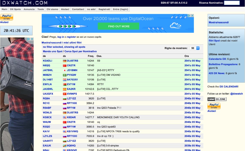 DX clusters aggregate real-time amateur radio spot data, enabling operators to identify active stations and propagation conditions across various bands and modes. DXWatch offers a web-based interface for this essential operating tool, allowing users to filter spots based on specific criteria such as band, mode, or callsign. The service integrates features like a customizable filter system and an external widget for embedding spot data on other platforms, enhancing its utility for DXers and contesters. Operators can access worldwide spot data, with options to zoom into specific regions like the US, Europe, or the North Atlantic, facilitating targeted DXing efforts. The platform also includes a watchlist feature for registered users, enabling personalized tracking of desired stations or entities. Real-time data on solar flux index (SFI), A-index, and K-index are displayed, providing crucial propagation insights alongside the DX spots.
 -
 DXKeeper is a robust, freeware logging application designed for amateur radio operators, providing extensive capabilities for managing two-way radio contacts. It records and organizes QSO data, integrates with various callbook CD-ROMs like _HamCall_ and QRZ.com for automatic data population, and supports real-time logging from digital mode software such as MMTTY and MixW. The software runs on Windows NT through 8, supporting both 32-bit and 64-bit systems, and is a core component of the DXLab Suite. This application offers detailed tracking for numerous awards, including DXCC, WAZ, WAS, and IOTA, highlighting needed entities and automating the QSL process. It generates QSL cards and labels, addresses envelopes, and facilitates uploading and downloading of QSO confirmations with eQSL.cc and Logbook of the World (LotW). DXKeeper also interoperates seamlessly with other DXLab Suite members like Commander for transceiver control and SpotCollector for DX spot aggregation, significantly streamlining contest and DXing operations by providing a unified interface for logging and station management, including over **40** supported awards and **3** major online QSL services.
 -
 A rugged motorized satellite antenna tracking system for construction by the home handyman
 -
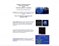 Real time tracking of an unlimited number of satellites, fast, accurate and easy to use. Automated FTP keps updates. Also support a great number of interface to control rotors azimuth and elevation plus frequency doppler shift. Since 2017 Nova is free to donwload and use. No support is given.
 -
 Select your favorite satellite and watch its trajectory on Google Maps in real time! Includes ISS tracking, Weather, Geostationary, GPS Military, and of course Amateur radio satellites. N2YO provides comprehensive real-time satellite tracking with particular emphasis on amateur radio satellites. The service offers precise pass predictions calculated for user-specific locations, displaying upcoming passes with azimuth, elevation, and duration data essential for ham operators planning satellite contacts. N2YO features dedicated tracking for amateur radio satellites including FM, linear transponder, and digital satellites, with frequency information and downlink/uplink details. The platform delivers live tracking visualizations on interactive maps, Doppler shift calculations, and automated email notifications for upcoming passes. This free resource integrates weather satellite tracking alongside NOAA imagery, making it invaluable for radio enthusiasts pursuing satellite communications.
 -
 PinPointAPRS offers a modern APRS solution with unique features for tracking and communicating with people using Ham Radio equipment. It is free for individual use and can be used as a tactical communications tool during emergencies. The software does not require an internet connection and is self-contained, making it versatile for various scenarios.
 -
 Winlog32 is a freeware amateur radio logging software designed for Microsoft Windows platforms, including versions from 95 up to 11. Developed by G0CUZ, this utility provides robust logging capabilities with a strong focus on DXing across both HF and VHF bands. It integrates extensive tracking for popular awards programs such as DXCC, IOTA, and WAZ, offering features expected from high-quality logging and DXing software. The software is provided without charge to all radio amateurs and SWLs, embodying the spirit of amateur radio. Colin Morris, G0CUZ, has continuously developed Winlog32 over many years, ensuring its functionality remains current and comprehensive. Users can download and utilize the software with full access to all features, free from limitations. While individual distribution is permitted, provided all original files remain unaltered and no charge is made, bulk distribution requires explicit authorization from the author. The software also supports integrations with tools like AGW Packet Engine, ARSWIN Rotator Control, Club Log, and HamQTH Callbook.
 -
 DX4WIN provides a robust logging solution for amateur radio operators engaged in DXing and contesting. This software streamlines the process of recording contacts, managing QSLs, and tracking award progress, which is essential for operators aiming for achievements like _DXCC_ or _WAZ_. Its intuitive interface simplifies data entry and retrieval, making it accessible for hams across all experience levels. The program integrates features for contest operation, including real-time scoring and duplicate checking, which can significantly improve a station's performance during major events. Operators can log thousands of QSOs efficiently, with support for various digital and analog modes. The software also offers tools for managing station equipment, such as rig control, to enhance operational flow. DX4WIN has been continuously developed, with updates addressing new operating practices and technologies. It supports ADIF export for compatibility with other logging platforms and award submission systems.
 -
 RadioRaft decodes 10 different ARQ modes, 8 different FEC modes, Packet, Baudot, CW... It works with a Hamcomm interface or a radiomodem. RadioRaft offers automatic detection of modes, speeds and shift. It comes with a frequencymeter/baudmeter included, it has signal frequency tracking and a bit by bit display mode. Very easy to use. practical and fast.
 -
 Swisslog, a robust freeware logging program, integrates seamlessly with various external devices and online services, making it a central hub for station operations. My field experience with similar logging software confirms the critical importance of features like real-time logging to services such as eQSL, QRZ, and Club Log, which Swisslog supports with both upload and download synchronization. The program also offers comprehensive award tracking for approximately 150 built-in awards, with the flexibility to add more, alongside detailed statistical reports. Beyond basic logging, Swisslog provides advanced functionalities like direct interfacing with popular digital mode software including WSJT-X, JTDX, and FLDIGI, ensuring accurate and rapid QSO entry for FT8 and other modes. It also supports multiple transceiver control (up to 8) from major manufacturers like Yaesu, Kenwood, and ICOM, and integrates with rotor control systems such as ARS-USB and Hy-Gain DCU. The _DX-Cluster_ integration is particularly useful, displaying spots with real-time award status and automatic detection for SOTA, POTA, and WFF from spot comments, which can significantly improve DXing efficiency. The software's world map feature includes various projections and layers for DXCC, IOTA, and WAZ, with a **double-clicking** function to turn the rotor, and provides accurate propagation predictions. It also supports multiple callbook and QSL manager databases, including QRZ and HamCall, and offers _multilanguage_ support in English, French, German, Italian, Portuguese, and Spanish.
 -
 Orbitron, a cardware application, provides robust satellite tracking capabilities for radio amateurs and visual observers alike. It leverages NORAD SGP4/SDP4 prediction models to accurately display satellite positions in real-time or simulation, accommodating up to 20,000 objects loaded from _TLE files_. The software includes an advanced search engine for satellite passes and _Iridium flares_, offering printable results for planning observations or QSO attempts. Sebastian Stoff's creation supports various visualization options, including a 'Nightlife' dark color scheme for nocturnal use, and integrates a database of cities and satellite frequencies. Users can synchronize their PC clock via NTP and update TLE data over HTTP, with ZIP support. The application also features rotor and radio control capabilities, either built-in or through user-defined drivers, which is particularly useful for automating antenna pointing during satellite passes. Its interface is designed for ease of use, making satellite tracking accessible even for beginners. First released in 2005, Orbitron 3.71 runs on Windows 9x/Me/2k/XP/2k3/Vista and can operate on Linux via _Wine emulation_, requiring minimal system resources. The software's precision relies on periodic TLE updates, especially for low-Earth orbit objects, to account for orbital decay and maneuvers by satellites like the ISS or Soyuz.
 -
 The ARS will allow to control any antenna rotator (Azimuth & Elevation) from a computer. Even if you are only interested on HF arrays, the ARS will allow it. Supported from most programs as CT for DOS, tracking programs.
 -
 APRS for Linux is a multifaceted system for use with packet radio by Hams, it allows the monitoring of real time geographical information such as the position of vehicles, the status of weather, radio direction finding and much much more. It envolves mapping, GPS tracking, packet radio, etc
 -
 Satellite Orbital Prediction and Satellite Tracking
 -
 Amateur Contact Log (AC Log) by N3FJP is a commercial Windows-based general logging program designed for amateur radio operators, supporting Windows 7 through 11. It provides comprehensive tracking for various operating awards, including Worked All States (WAS), Worked All Counties, Worked All Countries (WAC), DXCC, VUCC, Grids, Zones, IOTAs, and Lighthouses. The software features a customizable user interface, allowing operators to display specific data fields and adjust font sizes. It includes built-in databases for counties and countries, facilitates queries by band, mode, or power level, and offers a bearing and distance calculator for DX contacts. AC Log also provides DX spotting via Telnet or packet TNC, supports keyboard CW, and can play wave files. The program offers full support for ADIF import and export, enabling seamless integration with external services like eQSL, QRZ, Club Log, and the ARRL's Logbook of the World (LoTW) for QSO uploads and confirmation downloads. It interfaces with popular transceivers from Elecraft, Icom, Kenwood, Ten Tec, and Yaesu, and connects with digital mode software such as WSJT-X, Fldigi, and JTAlert via API. AC Log includes a Net Manager form for group logging, prints basic QSL label strips, and integrates with QRZ and Ham Call lookup services. The software is fully networkable for multi-PC operation, supports Parks on the Air (POTA) logging, and displays worked entities and DX spots on a real-time world map. Full featured Trial version available for 45 days
 -
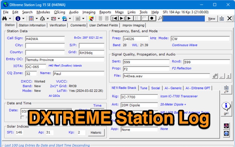 DXtreme Station Log 15 SE provides comprehensive logging functionalities for Amateur Radio operators, featuring robust _Logbook of the World_ (LoTW) support for automatic uploads, QSO record status capture, and QSL processing. The software integrates with _Afreet Omni-Rig_ for rig control and offers worked-before notifications for _WSJT-X_ and JTDX, streamlining digital mode operations. Its DX Spot Checker queries servers to indicate DXCC/VUCC status based on the user's database, utilizing Rich Site Feed or Grid Feed options. Key features include Improv Imaging and QSL Imaging for managing screenshots, documents, and QSLs, alongside Performance Reports for tracking station activity. The application incorporates AI functionalities, such as a Generic AI feature and a dedicated DXtreme GPT for specific instructions. DXtreme Interchange facilitates digitizing paper logbooks into ADIF-based project files, enabling rapid data entry and automatic field population. DXtreme Monitor Log 14, designed for radio monitoring, logs stations across the spectrum, including a Schedule Checker for broadcast stations from Aoki, EiBi, and FCC AM sites. It integrates with Afreet Band Master to identify needed Amateur Radio entities and supports reception report creation for QSLs.
 -
 CQLog, a Windows-based logging program, provides a comprehensive control center for everyday on-the-air activities, including full-featured QSO logging and statistics for numerous awards, with support for _LoTW_ and _eQSL_ capabilities. It integrates with callsign databases like QRZ, RAC, and GOLIST, and facilitates two-way data exchange with digital mode software such as MixW2 and DigiPan. The software also supports saving up to three pictures per SSTV-QSO and integrates with DX Atlas. This logging utility offers a dedicated "contest-mode" and supports CAT systems for popular transceivers from YAESU, ICOM, KENWOOD, and Ten-Tec. Users can print QSL cards, QSL labels, and address envelopes directly from the program. Its features streamline the logging process and provide tools for award tracking, making it a practical solution for hams managing their station activities and DXing pursuits.
 -
 Wintrak and traksat, satellite tracking software
 -
 jLog is a modern Freeware Ham Log program that can run on all major platforms, e.g. Mac OS X, Mac OS, Linux/Unix, Windows, etc. It offers a nice, clean interface and allows efficient entry of QSOs. Import or Export of data using the standardized ADIF 2 format is possible to easily exchange data with any other decent Log program. Built-in CW Keyer, CAT control for many popular, rigs, DX Cluster tracking, call lookups
 -
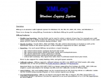 Version 7.22 of XMLog provides a fix for an issue where the ARRL LoTW application TQSL produced error messages concerning invalid "MY-COUNTRY" values, ensuring smoother integration for award submissions. The software supports flexible log searching, allowing users to select log subsets based on any field, such as RTTY QSOs on 40 meters during a specific month, or entries for a single country with sent but unreceived QSLs. XMLog tracks DXCC, WAZ, WAS, county hunting, IOTA, and grid square awards, managing QSL sent/received status and submission status to award sponsors, with LoTW crediting for DXCC and WAS. It generates detailed reports summarizing QSL status by band and mode, identifying needed countries/states/zones, and listing critical QSOs that could boost award totals. The system also integrates with callbook services like QRZ.com (subscription required) and WM7D.net for lookups, and facilitates QSL and mailing label printing using standard or custom layouts. Further capabilities include ADIF, Excel, and CSV log import/export, a Packet Window for Internet PacketCluster nodes or TNCs with history and scripting, and vocal/CW alerts for needed QSOs based on PacketCluster spots. Rig control is supported for a wide array of Alinco, Elecraft, Flex, Heath, Icom, JRC, Kenwood, TenTec, and Yaesu transceivers, enabling frequency/mode synchronization and control. CW support is provided via a serial port interface compatible with N1MM or K1EL WinKeyer, allowing CW sending from a keyboard or pre-programmed messages.
 -
 AALog v3.9.0 Build 1288 is a Windows-compatible logging program for amateur radio operators, supporting Windows 2000 through Windows 10. It integrates with CwType, CwGet, TrueTTY, and AAVoice for CW, RTTY, PSK31, and voice operations. The software facilitates online and offline QSO entry, duplicate checking, antenna direction, and distance calculations to DX stations. Key features include managing multiple logs under a single callsign or for different callsigns, and extensive award tracking for DXCC, WAZ, P-75-P, WAS, WAJA, JCC, JCG, WAIP, Russia, RDA, DPF, DDFM, WAU, and WPX, with user-definable award additions. It includes a built-in QSL-manager database, locator grid support, and detailed prefix lists. The program supports export to ADIF and text files, and import from ADIF, LoTW reports, Cabrillo, and AATest formats. External database integration is supported for Buckmaster HamCall CD-ROM, QRZ CD-ROM, RAC CD-ROM (Flying Horse), and Russian Internet Callbook. QSL manager databases like GoList, QSL Routes, and WinQSL are also compatible. The software package for v3.9.0 Build 1288 is 10,630,589 bytes.
 -
 Log4OM is a free logging software designed for amateur radio operators who require an integrated environment for station management and QSO logging. It is widely used by DXers due to its strong database capabilities and its integration with common online services. The program uses a structured SQL database and supports large logbooks without noticeable performance degradation. One of its key features is **CAT Control**, which allows direct communication with many transceivers for automatic frequency and mode detection. The **DX Cluster Client** provides real-time spotting with filtering and band/mode tracking, helping operators quickly identify new DX opportunities. Log4OM integrates with several external confirmation systems. Built-in support for **Logbook of The World (LoTW)** and **eQSL** allows automatic upload and download of confirmations. The software also includes **Award Tracking**, enabling operators to monitor progress toward DXCC and other award programs directly from the log. Additional capabilities include **Callbook lookup** via services such as QRZ, **ADIF import/export**, and customizable **QSL management** for both electronic and paper cards. The interface is modular, with panels that can be arranged depending on operating preferences. Log4OM does not include integrated digital mode engines, so digital operation normally relies on external programs such as WSJT-X or FLdigi connected through standard interfaces. Overall, Log4OM provides a comprehensive logging environment suitable for both casual operation and serious DX chasing, with a feature set comparable to many commercial logging applications.
 -
 Java moon tracking software runs on LINUX, Win 98, Win NT, UNIX, OSF, MacOSX
 -
 Demonstrates _EasyLog_, a commercial logging software for Windows, first released in 1989. The software automates QSO logging, manages awards, and integrates with LoTW for credit submission. It features powerful and intuitive award management, seamless DX-Cluster integration, and a reliable country recognition system, supporting over **37 years** of continuous development. EasyLog provides dedicated technical support and regular updates for awards and DXCC country recognition. Users gain 12 months of access to all software versions and Manager updates with each purchase or renewal, with an option for 13 months upon early renewal. This tool transforms station management, freeing operators from repetitive tasks and enhancing the overall radio experience for both new and experienced DXers. The software is priced at **39,95€** for new users, including 12 months of updates.
 -
 Useful hardware & software for SAT tracking ,logging, Software defined transceivers for SDR and more
 -
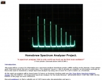 This is a tracking page for a tv tuners based homebrew spectrum analyzer project.
 -
 Kantronics produce Modems, Tnc, Kam, Marine, wireless modems. Packet radio communication devices, HF E-mail, paging, GPS tracking, weather data gathering, or wireless data transmission.
 -
 Demonstrates BBLogger, a **freeware** logging application designed for both amateur radio operators and Short Wave Listeners (SWLs). Developed by IK2VIW, IZ2BKT, and IK2UVR, this software provides comprehensive station management capabilities, including **CAT control** for various transceivers, integration with digital mode software like WSJT-X, JTDX, and MSHV, and robust QSL management features. The application supports a wide array of functions such as DX cluster interfacing, mapping, awards tracking (including custom awards), and direct integration with services like LoTW, eQSL.cc, and ClubLog for QSL confirmations and OQRS requests. It also includes utilities for ADIF to CSV conversion and vice-versa, catering to diverse logging and data management needs. Recent updates, such as version 13.1, introduce a web server for log management from any device, allowing remote access and control. The software has improved ADIF import capabilities, including time settings for duplicate QSO detection, and enhanced filtering options for log searches. Performance improvements include faster automatic updates and manager database synchronization, along with optimized log checking at startup. Earlier versions added support for FT8 and FT4 modes, refined OQRS integration with ClubLog, and expanded QSL/label printing functionalities, enabling users to select specific callsign types (OM, SWL) for printing. The developers emphasize compatibility with Windows 10/11 for full functionality, noting limitations when running on older operating systems like Windows 7 due to modern security protocol requirements.
 -
 Construction tips to build an automatic``satellite tracking rotor controller using``PIC16F877 IC.
 -
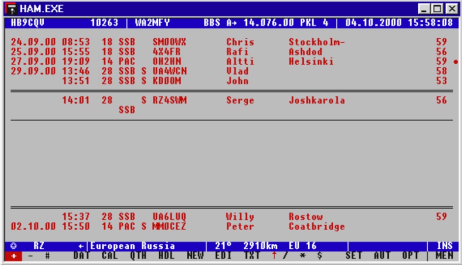 Facilitates efficient logging of amateur radio contacts, offering a robust solution for hams managing their station activities. The software integrates _CAT control_ capabilities, allowing direct interfacing with popular transceivers from manufacturers like Yaesu, Icom, and Kenwood. This feature streamlines the logging process by automatically capturing frequency, mode, and other QSO details directly from the radio, reducing manual entry errors and improving operational efficiency during contests or DXing. _HAM-LCT_ includes a comprehensive database, enabling users to store and retrieve contact information, QSL data, and other relevant details for each QSO. The program supports various operating modes and provides tools for searching and filtering log entries, which is beneficial for award tracking and station analysis. Its design focuses on providing a user-friendly interface for everyday logging tasks. While the original author, _HB9CQV_, has discontinued development of HAM-LCT in favor of a newer logging application, this version remains available as a functional freeware option for Windows users seeking a dedicated logbook with integrated rig control.
 -
 Tracking Interfaces and software for allmost every rotor
 -
 Packet/telemetry modems, GPS tracking, sound card interfaces
 -
 Over 45 years of amateur radio experience inform the homebrew projects detailed on this personal website, with a particular focus on microwave frequencies. The site showcases a 24 GHz transverter and a more recent 47 GHz transverter, demonstrating practical construction techniques for extreme high-frequency operation. These projects often involve custom circuit design and careful component selection to achieve stable performance at millimeter-wave bands. Key projects include a _harmonic converter_ for frequency measurement and a tracking spectrum analyzer, essential tools for microwave experimenters. The site also documents a CW sidetone generator and a TX/RX sequencer, illustrating fundamental building blocks for radio equipment. Details on a digital frequency meter and an S-meter/dBm meter provide insights into test equipment construction. Specific achievements, such as a **24 GHz** tropo QSO with DK3SE in 2021, highlight the operational success of these homebrewed systems. The content reflects a long-standing dedication to self-sufficiency in amateur radio, providing practical examples for those interested in building their own gear.
 -
 adsbScope is a freeware Windows application designed for processing _ADS-B_ (Automatic Dependent Surveillance-Broadcast) frames received from a compatible decoder. It identifies aircraft, calculates their real-time positions, and presents flight parameters in both alphanumeric tables and a graphical display. The software interfaces via a virtual COM port, receiving raw frames to provide detailed situational awareness, including a global coordinate grid, continental coastlines, over 4,000 **airport** locations, and major cities. Users can overlay OpenStreetMap tiles and view world state boundaries, with each tracked aircraft rendered with labels showing altitude, speed, heading, squawk code, and flight identifiers. When paired with the adsbPIC-decoder, adsbScope enables advanced hardware control, allowing users to toggle data filters for specific frames like DF17/18/19, adjust analog signal thresholds for reception fine-tuning, and manage system resets or bootloader activation directly from the PC. This functionality provides a customizable toolkit for hobbyist radar listeners, offering a robust alternative to commercial tools for processing aircraft data. The software displays up to **1090 MHz** transponder data and can track aircraft up to 250 nautical miles.
 -
 Demonstrates a **DX cluster** web service providing real-time amateur radio spot reports, propagation information, and solar data. The platform integrates features such as a gray line map, **DXCC** tracking, and a personal logbook, allowing users to manage their confirmed entities and contacts. It supports various bands from 160m to 70cm, including specific filters for modes like FT8/FT4, and offers both web and Telnet access for spotting and monitoring. The service provides graphical representations of spot reports, detailing activity across different frequency bands and modes (CW, SSB, digital). Registered users gain access to advanced functionalities, including personalized filters and tools for calculating DXCC status. The platform also includes a classifieds section and options for mobile access, catering to a broad range of amateur radio operators interested in DXing and contesting.
 -
 A 2-meter Turnstile antenna, detailed for amateur satellite communication, offers a straightforward build for those looking to engage with orbiting transponders. The author, WB8ERJ, shares his personal design and construction methods, emphasizing the antenna's simplicity and effectiveness for LEO (Low Earth Orbit) satellite work. This design provides a circularly polarized signal, crucial for mitigating _Faraday rotation_ and signal fading often encountered with linearly polarized antennas when tracking satellites. Construction involves readily available materials like PVC pipe and copper wire, making it an accessible project for many hams. The article includes practical advice on element spacing and feed point considerations, drawing from the author's hands-on experience in the shack and field. It highlights the antenna's utility for receiving signals from various amateur satellites, including the popular AO-91 and AO-92. The Turnstile's inherent omnidirectional pattern in the horizontal plane, combined with its circular polarization, yields consistent signal reception, often resulting in **stronger decodes** and **more reliable contacts** compared to basic dipoles or verticals.
 -
 Over 70 international contests are supported by YPlog, a Windows-based logging and radio control program designed for amateur radio operators. This software integrates with various digital mode applications like _WinPSK_, _HamScope_, and _MMTTY_, facilitating partially automated log entry for modes such as PSK31, CW, and RTTY. It provides comprehensive logging capabilities including QSL label printing, beam headings, and dup-checking, alongside award tracking for DXCC, ITU/CQ zones, IOTA, Grid Locators, and Counties. The program offers advanced contesting features, including multi-multi or multi-2 networked operations with automatic log data sharing, multiple Cabrillo submission formats, and configurable CW keyboard layouts. Device support extends to TR-compatible CW keying, SO2R control with Top-Ten devices like the DX-DOUBLER, and internal W9XT digital voice keyer integration. YPlog is notable for its support of the _OK1RR DXCC_ country resolution files, providing a robust historical DX compendium. Beyond logging, YPlog includes two freeware utilities: one for computing design parameters for coaxial traps and another for displaying and printing azimuth and Mercator maps from the operator's QTH. The software runs on Windows 95/98/ME/NT/2K, with a recommended screen resolution of 1024x768. Registration costs **$50.00 US** to unlock all features, including full contesting capabilities and rotator control.
 -
 5 Day prediction table for ISS and find when the ISS will be visible from your QTH by N2YO
 -
 Freeware windows RTTY PSK31 software decoder that allow logging, award tracking and qsl printing. By SQ1FTB
 -
 PstRotator handles just about every controllable rotator in common use: Prosistel, Green Heron, HyGain, RC1 MDS, Rotor-EZ Idiom Press, Yaesu Az and many more PstRotator includes automatic tracking for satellite or EME communications, using programs like WSJT, VQLog, TACLog, Z-Track, GJTracker, EME System, Trak_SM, WXtrack, WinOrbit, Orbitron, Nova for Windows, Sat_Explorer, SatPC32, Win-Test. PstRotator supports remote control over TCP/IP.
 -
 Demonstrates a comprehensive logging and contest program for Windows, _UCXLog_, designed to assist amateur radio operators in managing their QSO records and participating in competitive events. It integrates essential features such as transceiver control for single-operator two-radio (_SO2R_) setups, CW keying via COM/LPT ports, and SSB/RTTY operation through soundcard interfaces. The software also provides DX cluster connectivity via packet, internet, or Telnet, alongside robust statistics tracking for awards like _DXCC_ and _IOTA_, locator management, and greyline map display. Enables operators to efficiently handle log import/export functions, print QSL cards, and maintain detailed records of their contacts. The program's network capability facilitates multi-operator environments, while its support for various digital modes and rig control protocols enhances operational flexibility. Regular updates, including beta versions, are provided, ensuring ongoing development and feature enhancements for the amateur radio community.
 -
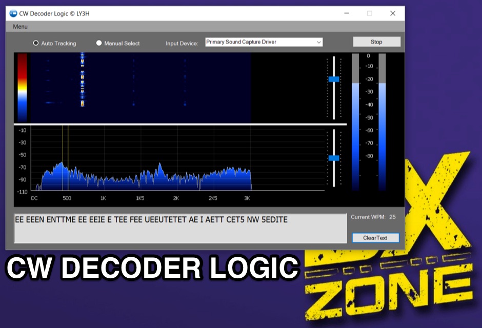 Demonstrates CW Decoder Logic, a freeware application for Windows Vista SP2, 7, 8, and 10, designed to decode Morse code signals. The software incorporates an optimized 80 Hz DSP filter, enabling reception of CW signals across a speed range of 5 to 60 WPM. Key features include automatic signal tracking within a 3 KHz range, real-time speed detection, and an auto squelch function, enhancing decoder sensitivity and accuracy. The application provides station selection directly on a waterfall display and includes a "Tips" feature for word annotations. It supports sending decoded text to external logging software via UDP protocol, with a logger source code example provided for developers. Configuration options allow users to set speed limitations and customize interface elements. Released initially on October 17, 2016, with subsequent updates, the program requires Microsoft .NET Framework 4.5 or higher. Changelogs detail improvements such as increased program stability, code optimizations for speed, and fixes for display issues across different Windows versions.
 -
 Operating amateur radio satellites effectively requires precise knowledge of their orbital mechanics and pass times. Gpredict, a real-time satellite tracking and orbit prediction application, addresses this need by allowing operators to monitor numerous satellites simultaneously. It displays critical data such as position and pass details through various visualizations, including lists, tables, maps, and _polar plots_. Unlike many other satellite tracking programs, Gpredict introduces the concept of visualization modules. These modules enable users to group satellites and configure each group independently, offering unparalleled flexibility in how orbital data is presented. This modular approach supports tracking satellites from multiple observer locations concurrently, which is particularly useful for stations with diverse antenna setups or remote operations. Originally a GUI client for John Magliacane's _Predict_ program, Gpredict evolved to integrate its own tracking code for improved performance. The software is distributed under the GNU General Public License, ensuring it remains free and modifiable for the amateur radio community.
 -
 Ground tracks are the trace of the satellite's path over the ground. Amsat, ISS, geosynchronous satellites, navigation satellites, weather satellites, Iridium satellites, visible Satellites. Requires Java
 -
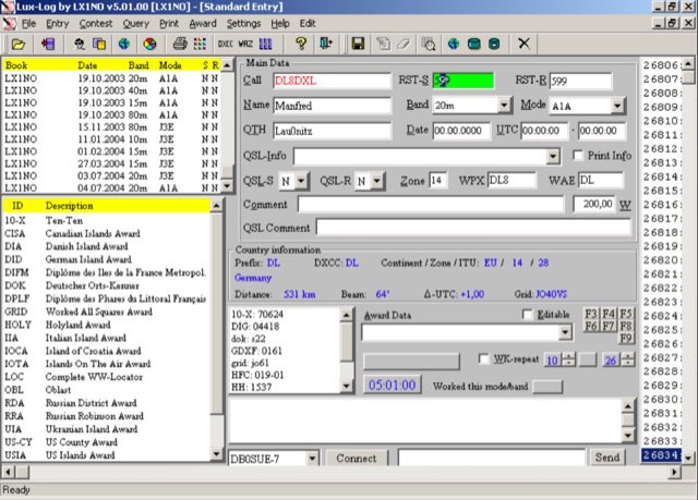 For amateur radio operators running Microsoft Windows XP or later, Lux-Log provides a robust logging and contest software solution, designed by Norbert Oberweis, LX1NO. It is capable of managing over 30,000 logbooks within a single database and image copy, offering comprehensive data handling features. The software facilitates data import and export via **ASCII** and **ADIF** formats, ensuring compatibility with other logging applications, and includes an integrated tool for converting data from other programs into ADIF. It provides instant feedback on previous contacts and country information during data entry, alongside static or serial value generation for contesters. Lux-Log integrates a versatile award module, currently supporting 123 definitions for popular awards such as DXCC, WAZ, WAS, US Counties, IOTA, and more. Operators can generate pre-defined and user-definable data queries, visualize statistics through bar/pie charts, and print QSL labels. The software also interfaces with the RAC Callbook and HamQTH, supports LoTW, and offers radio control for Icom and Yaesu FT-857 transceivers. Additionally, it supports telnet connections to internet clusters and integrates with K1EL's WinKey for CW generation, making it a comprehensive tool for both general logging and contesting activities.
 -