Search results
Query: mapping
Links: 40 | Categories: 3
-
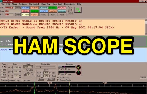 HamScope v1.56, released on 2007-03-20, functions as a multi-mode communications interface for amateur radio, supporting digital modes such as PSK31 (BPSK and QPSK), RTTY, ASCII, MFSK16, PACKET, and CW. The software integrates with external engines like _MMTTY_ for RTTY/ASCII and AGWPE for PACKET operation. It features a panoramic waterfall display, 42 user-programmable macro buttons, and user-definable function key mappings, providing operators with enhanced control during digital mode operations. The program includes a radio control interface compatible with several ICOM, TenTec, Kenwood, and Yaesu transceivers, enabling direct rig control. HamScope also establishes data links with various logging and radio control applications, including LOGic 7/8, DXbase 2004, RYLogit, and TRX-Manager, facilitating seamless data exchange and logging. A DDE server is available for custom connections. Designed for Windows 98 and NT, HamScope requires a 133 MHz Pentium-class machine and 16-bit SVGA color. While not officially supported, users have reported functionality on Windows 95, ME, XP, and 2000, though some issues with window settings or the MMTTY engine may occur. The software is distributed as a single executable file, with separate downloads required for MMTTY and AGWPE engines.
 -
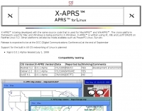 APRS for Linux is a multifaceted system for use with packet radio by Hams, it allows the monitoring of real time geographical information such as the position of vehicles, the status of weather, radio direction finding and much much more. It envolves mapping, GPS tracking, packet radio, etc
 -
 Windows contest logging software with multiple functions like antenna rotor control, dx cluster, cat control, voice and cw keying, supports many data modes, qrz lookup, pirint qsl and labels, mapping and more. Donationware software.
 -
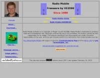 Radiomobile is an excellent and very detailed radio path mapping software, vhf uhf propagation predictor. This windows free software is a tool used to predict the performance of a radio system.
 -
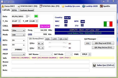 Demonstrates BBLogger, a **freeware** logging application designed for both amateur radio operators and Short Wave Listeners (SWLs). Developed by IK2VIW, IZ2BKT, and IK2UVR, this software provides comprehensive station management capabilities, including **CAT control** for various transceivers, integration with digital mode software like WSJT-X, JTDX, and MSHV, and robust QSL management features. The application supports a wide array of functions such as DX cluster interfacing, mapping, awards tracking (including custom awards), and direct integration with services like LoTW, eQSL.cc, and ClubLog for QSL confirmations and OQRS requests. It also includes utilities for ADIF to CSV conversion and vice-versa, catering to diverse logging and data management needs. Recent updates, such as version 13.1, introduce a web server for log management from any device, allowing remote access and control. The software has improved ADIF import capabilities, including time settings for duplicate QSO detection, and enhanced filtering options for log searches. Performance improvements include faster automatic updates and manager database synchronization, along with optimized log checking at startup. Earlier versions added support for FT8 and FT4 modes, refined OQRS integration with ClubLog, and expanded QSL/label printing functionalities, enabling users to select specific callsign types (OM, SWL) for printing. The developers emphasize compatibility with Windows 10/11 for full functionality, noting limitations when running on older operating systems like Windows 7 due to modern security protocol requirements.
 -
 D-RATS is a small application designed to provide data communication capabilities with D-STAR radios. It supports text chatting, file transfers, position reporting and mapping, and much more! It is written in Python using GTK to run on multiple platforms.
 -
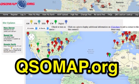
 DXMaps.com presents a dynamic, real-time mapping service for amateur radio DX spots, integrating data from traditional DX clusters, _PSK Reporter_, and WSPR networks. The platform visually plots global QSO and SWL activity, enabling users to observe propagation conditions across various bands, from 2200m to >450 MHz. It offers distinct overlays such as the magnetic equator, gray line, moon footprint for EME, and VOACAP propagation predictions, providing a comprehensive view of radio wave behavior. The service allows granular filtering of displayed spots, including options to show only DX-Cluster data, PSK Reporter activity, or WSPR signals. Users can refine the map view by selecting specific bands (e.g., 160m, 20m, 6m, 2m), limiting spots to the last 15 minutes, or displaying only contacts exceeding **2600 km**. Additional features include the ability to toggle grid squares, aurora forecasts, and various amateur radio zones (CQ, ITU). Distinctively, the resource updates automatically every minute, ensuring current propagation intelligence without manual refresh. It also supports specialized views for EME, ionospheric scatter, and aircraft scatter, alongside FM DX and APRS activity. The platform emphasizes the importance of accurate locator information in DX spots to enhance data quality and offers a user manual and FAQ for guidance.
 -
 A large collection of amateur radio maps, including CQ and ITU Zones, a complete set of ham radio Prefix Maps, grid locators and time zones map. An excellent ham radio mapping service.
 -
 A web site offering a QRZ.com integrated mapping service. Allows creating a google map of your QSOs adding a list of QSOs manually or importing an ADIF log file. Registration and a QRZ.com account is required.
 -
 RF Path design software, tower coverage mapping software to evaluate radio transmitter sites, predict and simulate radio coverage, plan land mobile radio or cellular systems. Commercial RF coverage mapping software by Softwright llc.
 -
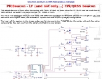 This resource details the construction of a versatile CW/QRSS beacon, designed around a Microchip _PIC16F84_ microcontroller. The project provides a flexible platform for transmitting either standard CW or very slow QRSS signals, making it suitable for LF, VHF, UHF, and SHF applications. It supports two distinct messages, each configurable for speed (from 0 to **127** WPM for CW, or up to **127** seconds per dot for QRSS) and repetition within a six-phase sequence. The core functionality relies on the PIC's EEPROM, which stores all operational parameters, including message content, transmission speeds, phase configurations, and relay control settings. This design allows for parameter modification directly via programming software like _ICProg_ without altering the main program code. The project includes a detailed schematic, a component list, and an explanation of the EEPROM memory mapping for messages, speeds, phase settings, and inter-phase delays. General-purpose outputs (OUT1, OUT2, OUT3) provide dry relay contacts for external control, enabling functions such as power switching, antenna selection, or frequency changes. A 'TRIGGER' input facilitates controlled starts or continuous free-run operation. Sample EEPROM configurations illustrate how to program specific beacon sequences, including message content and relay states.
 -
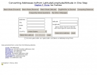 This online tool will convert any street address into latitude and longitude and vice-versa by executing queries to several online mapping services like googlemap geocoder maporama terraserver and more by Stephen P. Morse
 -
 SWIFT WX Version 2.0 combines a powerful GIS mapping engine with real-time weather maps and storm tracking data making it the most comprehensive storm tracking application available.
 -
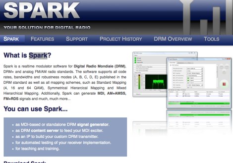 Spark is a realtime modulator software for Digital Radio Mondiale DRM, DRM+ and analog FM/AM radio standards. The software supports all code rates, bandwidths and robustness modes (A, B, C, D, E) published in the DRM standard as well as all mapping schemes, such as Standard Mapping
 -
 Mapping software which links a Garmin GPS receiver to your Macintosh. Includes Maidenhead grid squares and beam-pointing maps.
 -
 World Time and Mapping software including Azimuthal Maps.
 -
 Over 47 full-screen maps are available within _NAOMI_ (North American Overlay Mapper), a free Windows program designed for US and Canadian amateur radio enthusiasts. This mapping suite includes 9 backgrounds such as CQ Zones, ITU Zones, and ARRL Sections, along with 16 foreground layers like Counties, Areacodes, and Grid Locators. Users can calculate distances and bearings, track real-time mouse positions with continuous Grid-Locator data, and integrate with APRS for live station tracking via the FindU database. For a global perspective, the _Global Overlay Mapper_ (GOM) provides a world map, 8 continental maps, and 29 sub-continental maps, all with 12 active layers including Country Outlines, CQ/ITU Zones, and Prefix information. Both NAOMI and GOM offer feature-locate systems to jump to positions based on prefixes, capital cities, or Grid Locators, and provide customized beam headings and distance displays. The site also features _LogView_, a post-contest log visualization tool that analyzes Cabrillo-format logs by plotting QSOs on maps, supporting over 30 major contests like CQWW and ARRL DX, and allowing comparison with published results.
 -
-
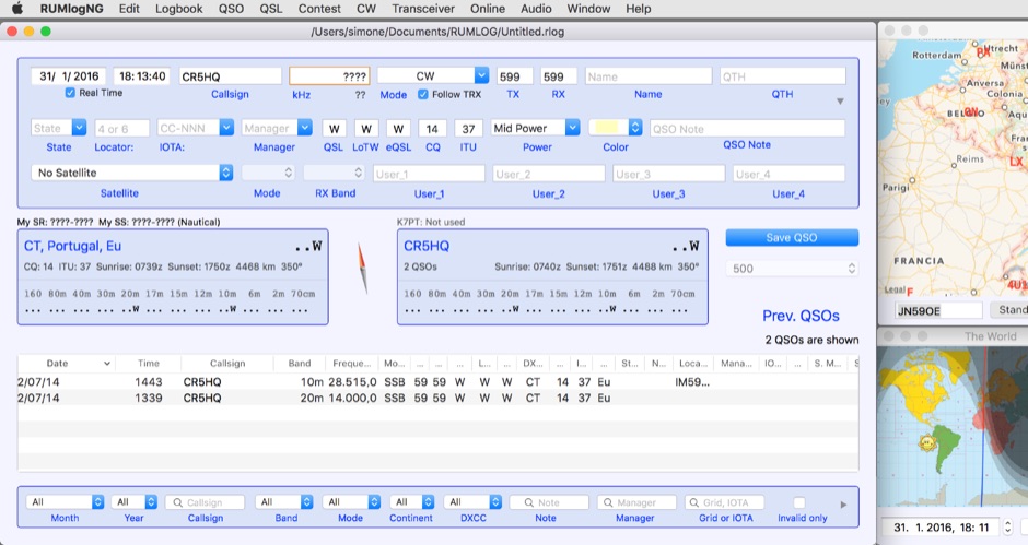 For macOS users engaged in amateur radio operations, a robust logging solution is essential for tracking QSOs, managing contest entries, and handling QSLs. RUMLog addresses these needs by providing a fully featured logbook program designed specifically for the Apple ecosystem. It integrates capabilities such as transceiver control for popular Icom, Elecraft, Yaesu, and Kenwood rigs, CW keyer interfacing, and real-time DX cluster monitoring. The software also includes mapping functions, callsign checking, and extensive import/export options for various log data formats. RUMLog's design supports both general logging and specialized contest operations, offering tools for efficient entry and submission. Its QSL handling and printing utilities streamline the confirmation process, a critical aspect for award pursuits like _DXCC_. The program's ability to interface with a wide array of transceivers via _Hamlib_ or proprietary protocols ensures broad compatibility, allowing operators to leverage its features across different station configurations. The free availability of RUMLog makes it an accessible option for macOS-based hams seeking a powerful logging utility.
 -
 Displays amateur radio grid squares worked from third-party logging programs, providing a visual representation of contacts on a world map. This Windows application uses colors to differentiate up to four bands concurrently, calculating the total number of grid squares worked per band. It reads plain-text log files, including fixed-width, character-delimited, ADIF, and Cabrillo formats, dynamically updating the map as log files are saved during contests or general operation. Primarily targeting **VHF** and above operators, WorkedGrids aids in grid square collection for contesting and awards. The software offers a fixed-resolution continental viewpoint, zoom-in capabilities, and supports printing or copying the map to the clipboard. It operates on Windows 95 through Windows 11, requiring minimal CPU and RAM, and features a non-invasive installation. The program has undergone several updates, with version 7 released on March 3, 2024, addressing minor fixes and improving stability.
 -
 A 2x3-foot laminated world map product is detailed, offering customization for amateur radio operators. Each map features two distinct views: one centered on the operator's specific station location and another precisely centered on its _antipode_. Countries are clearly labeled, complemented by a tabular listing of all countries. The map integrates a standard latitude/longitude grid alongside concentric circles that delineate distance increments radiating outward from the operator's QTH. Personalization includes the operator's name, callsign, and location printed directly on the map. This custom mapping service provides a unique visual aid for DXing and propagation analysis, allowing operators to quickly ascertain beam headings and distances from their station. The dual-view presentation, particularly the antipodal centering, offers a practical reference for understanding long-path propagation and identifying potential DX opportunities. The inclusion of distance circles and personalized station data makes it a tailored tool for daily operating and contest planning, distinct from generic world maps.
 -
 Depiction mapping software can download and integrate maps, elevation plots, weather data, situation reports, damage assessments, volunteer movement, and more. It interface with your APRS ssystem
 -
 The CES Wireless Technologies website details a range of **GPS fleet tracking** solutions designed for mobile information systems. It highlights offerings such as dispatch and mapping software, Automatic Vehicle Location (AVL) systems, and mobile data display terminals. The platform also mentions support for Automatic Number Identification (ANI) and Continuous Tone-Coded Squelch System (CTCSS) functionalities, indicating integration with two-way radio communication protocols. Specific products include GPS tracking devices and associated software for fleet management, emphasizing features like real-time location monitoring and operational efficiency. The site positions itself as a manufacturer in this specialized domain, catering to commercial and public safety sectors requiring robust mobile data solutions. While the page title mentions "Ham Radio Directory" categories, the content primarily focuses on commercial GPS and fleet management technologies, not amateur radio applications. The listed products are geared towards professional mobile radio (PMR) environments rather than typical ham radio operations.
 -
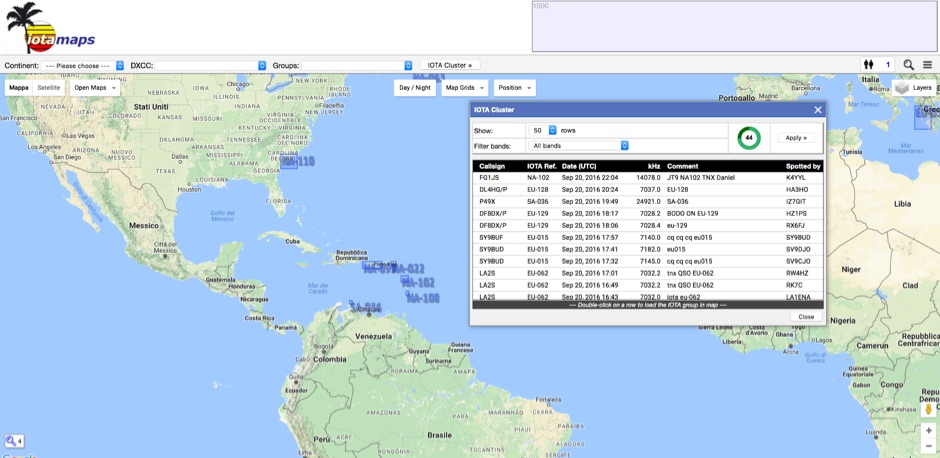 iota mapping project - a mapping resource for the IOTA (Islands On The Air) award program
 -
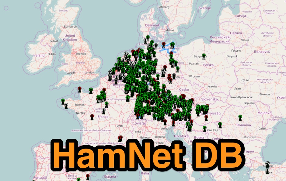 Hamnet IP-Database mapping system mostly european based.
 -
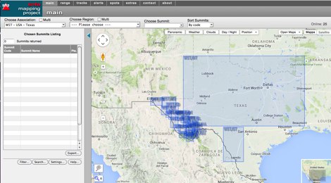 An interactive map for sota operations. SOTA Activators and cheasers will find this summits mapping site very useful resource. Based on Google maps.
 -
 The DXCC World Map web application is a modern and interactive mapping tool designed for shortwave radio enthusiasts. It showcases a high-quality world map along with the Sun's position, sunrise and sunset times, the terminator, coordinates, QTH locator, azimuth, azimuth map, current DXCC list, Aurora, and WWV Geophysical Alert Messages. Additionally, it provides the SFI, X-Ray, Kp, and Ap indices.
 -
 DX Maps provides a specialized map printing service, focusing on amateur radio applications such as world prefix maps and custom great circle projections. The platform allows radio operators to visualize propagation paths and DX entities relevant to their QTH and operational goals. This service supports the creation of high-quality, large-format maps tailored for shack display or operational planning. The service facilitates the generation of personalized maps, which can include specific callsign locations, beam headings, and other critical amateur radio data points. Users can specify parameters to create maps that aid in understanding global propagation conditions and optimizing antenna aiming for long-distance contacts. The UK-based operation ensures a localized service for European hams, with international shipping options available. DX Maps also offers QSL card printing, complementing its mapping services.
 -
 Approximately 524,475 Brazilian amateur radio operators are cataloged within this resource, offering a comprehensive database for the South American region. Each entry includes geographical coordinates, enabling users to visualize station locations directly within Google Earth. This functionality supports DXers in identifying potential contacts and understanding propagation paths relative to specific Brazilian QTHs. The platform serves as a digital callbook, primarily focused on the Brazilian amateur radio community. It facilitates the lookup of callsigns and associated location data, which is crucial for award tracking, contest planning, and general operational awareness. The integration with mapping services provides a visual dimension to traditional callsign databases, enhancing the utility for operators interested in geographical aspects of radio communication.
 -
 Time Mapper UHD is a versatile mapping and time visualization program offering multi-satellite viewing with frequency display and unique country-pairs for PskReporter data. It features live feeds from logging programs and can plot ADIF files. Ideal for schools, offices, or amateur radio stations, it provides customizable 4K or HD world clock displays with over 60 map layers, including ham radio zones and natural features. The program supports various time functions and can import logs for detailed analysis. It runs on Windows 10 or 11 and offers a 30-day free trial.
 -
 First released in 1988, _SWLog_ is a comprehensive suite of applications providing logging and remote control for both amateur radio and shortwave, utility, and broadcast listening. It integrates program schedules from sources like _HFCC_, _ILGRadio_, and _EiBi_ for broadcast reception, while also linking with amateur radio logbooks such as _ClubLog_, _eQSL_, _QRZ_, and _LoTW_. The software supports radio control for various transceivers, including _Flex_, Icom, Yaesu, and Kenwood, alongside interfaces like _FLRig_, _OmniRig_, and _HamLib_. Mobile applications for Android and iOS facilitate on-the-go logging and remote control, seamlessly transferring logs without manual ADIF export. _SWLog_ leverages an enterprise-grade relational database (SQL Server) for robust data management and analytics, enabling features like mapping QSOs by band or state. It offers specific integrations for _POTA_ monitoring, displaying active spots with real-time propagation and automatic radio tuning. The application's scalability allows multiple users to log to a centralized database, suitable for Field Day or DXpeditions. The user interface features modern aesthetics with light, dark, and gray themes, the latter optimized for outdoor visibility during activities like _POTA_ or _SOTA_. The Plus Edition, available for an annual fee, expands capabilities with advanced QSL integration, additional map providers, and enhanced propagation calculations using _VOACAP_.
 -
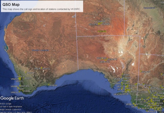 This project is a python program used to plot the location of QSOs (radio contacts) on Google Earth or other mapping applications. It reads an ADI file of the QSOs and creates a KML file
 -
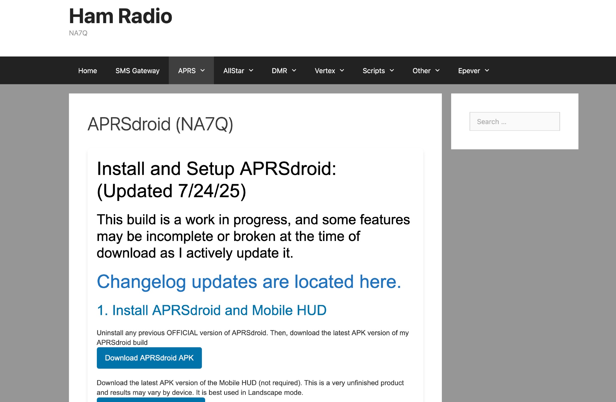 This page provides instructions and links to download the latest APK version of APRSdroid and the Mobile HUD for ham radio operators. It also includes information on manually granting storage permissions for offline mapping files on Android 11+ devices. The page offers guidance on setting up and using offline maps in APRSdroid with OpenStreetMap.org. Various mapping options and providers are mentioned, along with a recommendation to support the author on Patreon. Overall, this resource aims to assist hams in effectively utilizing APRSdroid for their amateur radio activities.
 -
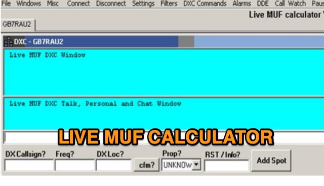 Live MUF is a DXC (cluster) telnet client which attempts to resolve propagation modes from spots and also attempts to calculate sporadic e possibilities purely based on incoming data from the cluster. It has great circle mapping (GCM) built in to the app for live mapping of spots. Live MUF also can be used as a world wide converse telnet client, ON4KST telnet client and DXC at the same time. Live MUF also has basic logging capabilities in case you need an emergency logger at any time.
 -
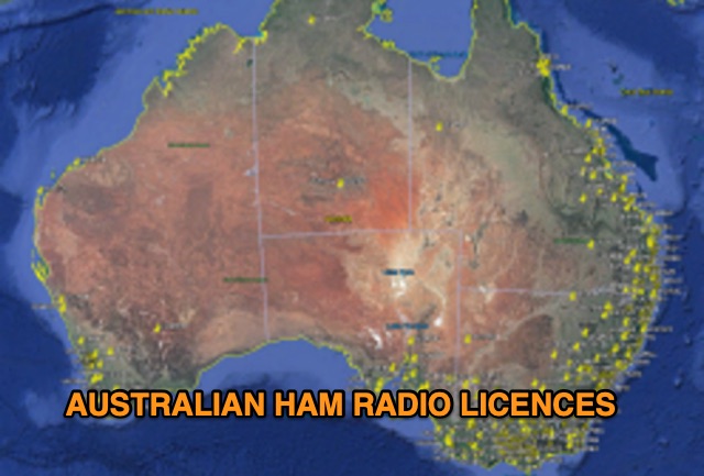 Discover a comprehensive solution for mapping Australian ham radio entities using data from the ACMA Public Register. This tool, developed in Delphi 7, generates KML files for Google Earth, showcasing repeaters, beacons, and operators across different prefixes. While respecting privacy regulations, the files provide valuable insights into the amateur radio landscape.
 -
 This page showcases the use of ChatGPT for quickly creating a prototype application that maps out individual QSOs from a CZML map. The author details the process of using ChatGPT to generate code that positions and frames a Cesium Ion map based on data from a czml file. The page includes links to the original map, the prototype app, a video demonstration, and the mapped QSOs output. The content is aimed at hams interested in experimenting with AI tools for ham radio applications.
 -
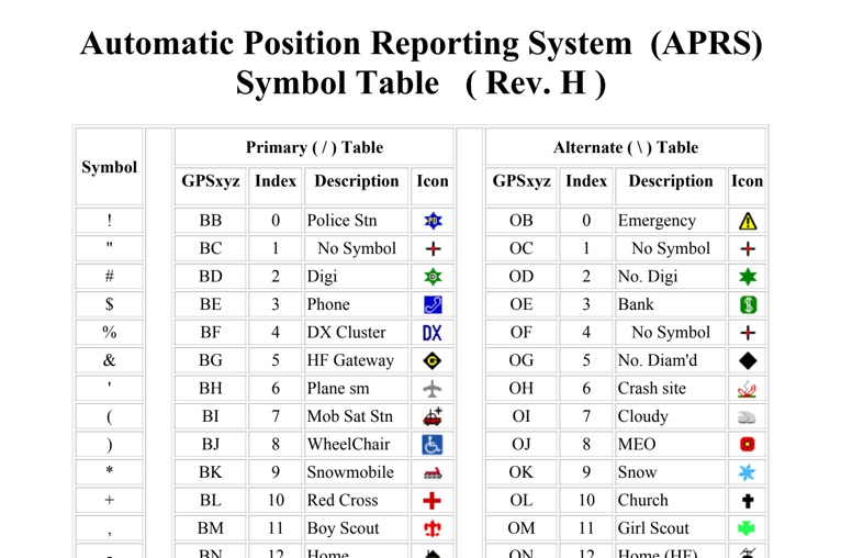 The four-page _APRS Symbol Table_ (Revision H) systematically lists 96 primary and 96 alternate Automatic Packet Reporting System symbols, each with its corresponding GPSxyz Index, a concise description, and a visual icon. For instance, the primary symbol '!' (GPSxyz BB) represents a "Police Stn," while its alternate counterpart '!' (GPSxyz OB) signifies "Emergency." The resource clearly delineates how specific ASCII characters map to distinct graphical representations on APRS displays, crucial for accurate situational awareness. It presents a direct, tabular format, making it an efficient reference for operators needing to quickly identify or interpret the myriad of icons used in APRS mapping applications. The table covers a broad spectrum of common APRS entities, from fixed stations like "Digi" (#) and "Home" (-) to mobile units such as "Car" (>) and "Plane sm" ('), alongside various weather phenomena and emergency services. Compiled by VK4KTP and featuring images by WA8LMF, the document serves as a definitive guide for understanding the visual language of APRS. It is particularly useful for those involved in tactical communications, public service events, or general APRS tracking, ensuring consistent symbol interpretation across different platforms and user interfaces.
 -
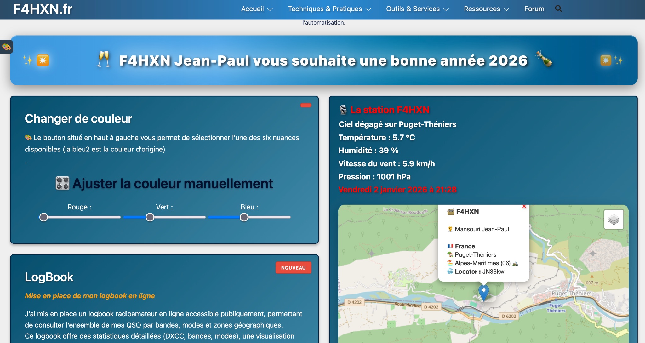 Demonstrates various technical projects and tutorials for amateur radio operators, focusing on digital modes, monitoring, and station setup. It covers topics such as implementing a _WSPR_ station, setting up ADS-B reception, configuring a _DXSpider_ cluster, and utilizing monitoring tools like Prometheus and Grafana. The resource provides practical guides for integrating modern IT solutions with ham radio activities, including Docker and Linux environments for radio applications. This site also features a publicly accessible online logbook, offering detailed statistics on QSOs by band, mode, and geographical zone, with visual mapping of contacts. It includes a comprehensive amateur radio lexicon, explaining hundreds of terms, and provides a real-time display of the F4HXN station's local weather conditions. The resource also aggregates information on upcoming ham radio events and offers a **SWR simulator** for antenna analysis, allowing users to visualize ROS changes based on frequency and antenna parameters.
 -
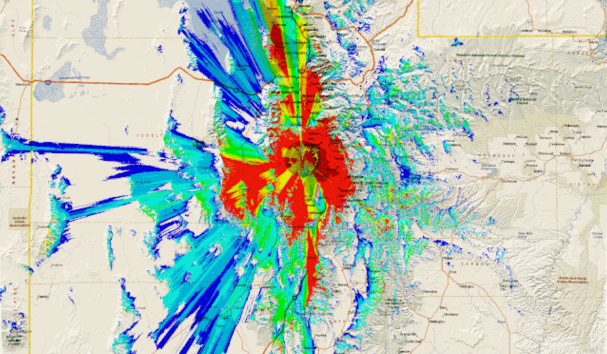 This study analyzes the antenna pattern of the Utah Amateur Radio Club's 146.760 MHz repeater following antenna relocation in 1997. Noting degraded transmission toward the north, a customized signal mapping system using a Yaesu FT-817, GPS, and software was developed to log real-time signal data. Calibration techniques extended the radio's signal range, enabling precise field measurements. The method allowed continuous signal strength monitoring while driving, revealing anomalies in coverage likely due to tower modifications. Findings helped assess and visualize the antenna’s actual radiation pattern and highlighted environmental impact on signal distribution.
 -
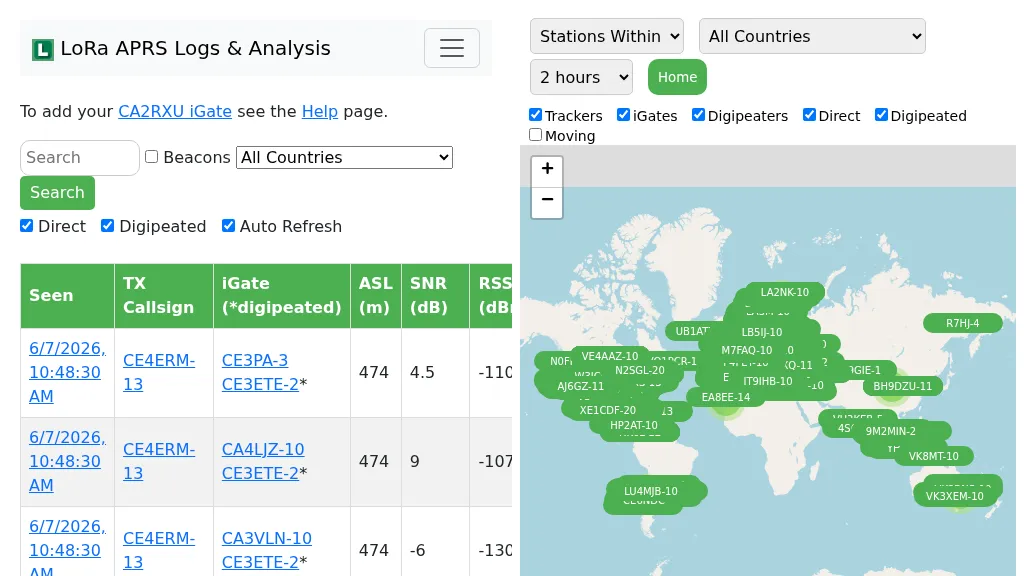 Demonstrates the operational status and reach of the LoRa APRS infrastructure, providing a live mapping and logging service for network participants. Users can verify network coverage, monitor _iGates_, and track mobile stations, observing messages and real-time network activity. The platform offers insights into station locations and data flow within the LoRa APRS system, which is crucial for understanding the performance of LoRa technology in Automatic Packet Reporting System applications. This utility helps amateur radio operators understand where transmissions are being received and processed by iGates, and how mobile units are moving within the network. The site's analysis tools provide RF performance monitoring and metrics, enabling users to assess network efficiency and identify areas for improvement. For example, operators can see how many packets are received by specific iGates, or track the path of a mobile station over a **100 km** range, offering practical insights into signal propagation and network reliability for _packet radio_ enthusiasts.