Search results
Query: Regions
Links: 53 | Categories: 9
Categories
- Shopping and Services > Regional > Other regions
- DX Resources > DX Peditions > 2016 DXpeditions
- Ham Radio > Clubs > North America > USA > Arkansas
- Shortwave Radio > Broadcasters > Clandestine Radios
- Radio Scanning > Regional > Europe
- Ham Radio > Clubs > Asia > India
- Radio Scanning > Police Scanning
- DX Resources > Prefixes
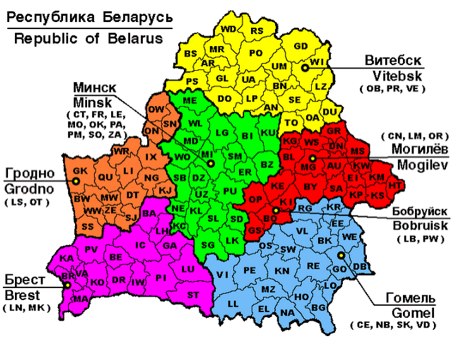
- Ham Radio > Regional
-
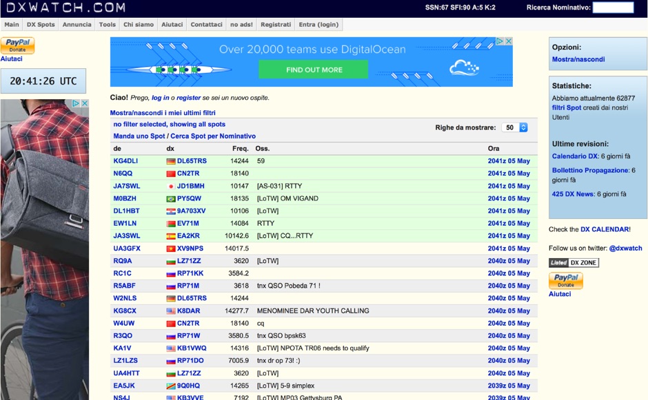 DX clusters aggregate real-time amateur radio spot data, enabling operators to identify active stations and propagation conditions across various bands and modes. DXWatch offers a web-based interface for this essential operating tool, allowing users to filter spots based on specific criteria such as band, mode, or callsign. The service integrates features like a customizable filter system and an external widget for embedding spot data on other platforms, enhancing its utility for DXers and contesters. Operators can access worldwide spot data, with options to zoom into specific regions like the US, Europe, or the North Atlantic, facilitating targeted DXing efforts. The platform also includes a watchlist feature for registered users, enabling personalized tracking of desired stations or entities. Real-time data on solar flux index (SFI), A-index, and K-index are displayed, providing crucial propagation insights alongside the DX spots.
 -
 The page provides a tool to create a customized Ham Radio Az Map on the fly, with various dimensions available. It is a valuable resource for amateur radio operators to visualize and optimize pointing of directional antennas. The content includes maps for different regions, prefix maps, and world maps.
 -
 For amateur radio operators seeking to confirm two-way radio contacts, a QSL card serves as a traditional, tangible verification. ON5UR QSL Printing provides a service for designing and printing high-quality, full-color QSL cards, including options for full-color backsides. The service offers various paper weights, such as 250, 280, 300, and 400 grams, allowing hams to select a card stock that meets their preferences for durability and feel. Pricing structures are detailed for different quantities, with 1000 cards starting at 96.00 Euro for 300-gram stock with gloss laminate, inclusive of design costs. The service includes free QSL cards with larger orders, such as 500 free cards with a 2000-card order, or 500 free cards with a 7000-card order. Shipping costs are categorized into six zones, primarily covering Europe, with specific pricing for countries like Belgium (Zone 1) and a request-based system for other regions and export conditions outside Europe. Testimonials from operators like M0URX highlight the design quality and quick turnaround, which are crucial for DXpedition QSL managers needing efficient processing.
 -
 Illustrates the global distribution of **DX-Cluster** nodes through an interactive map interface, enabling radio amateurs to visualize and access real-time DX spots. The resource provides direct TELNET and HYPER links for each node, facilitating immediate connection to various clusters for up-to-the-minute propagation information and station activity. This visual approach simplifies the process of locating and connecting to a suitable DX-Cluster, whether for local or international DXing. Amateurs can use this tool to quickly identify active clusters in different geographic regions, which is particularly useful for **DXpedition** planning or contest operations. The direct links streamline access, bypassing manual configuration for many cluster types. It serves as a practical aid for operators seeking to monitor band conditions, find rare DX, or participate in competitive operating events by leveraging aggregated spotting data.
 -
 The image is a all in one map of ITU Zones displaying worldwide regions and zones. It provides information on ITU Regions at IARU website, aimed at radio amateurs and technical users. Image size is in hight resolution and jpeg format, free to download.
 -
 Understanding high-frequency (HF) skywave propagation is crucial for amateur radio operators seeking to optimize long-distance communications. This resource details the fundamental principles of HF radio propagation, including the properties of electromagnetic waves, the characteristics of various HF bands, and distinct propagation modes such as skywave, ground wave, and line-of-sight. It places significant emphasis on the ionosphere's pivotal role in refracting HF waves, explaining how solar activity directly influences ionospheric conditions and, consequently, propagation paths. The resource integrates real-time monitoring capabilities, featuring dynamic charts and data from DX clusters, WSPRnet, and the Reverse Beacon Network, which allow users to track current band activity and propagation conditions globally. It also delves into advanced topics like Near Vertical Incidence Skywave (NVIS) and gray line propagation, providing insights into ionosonde data and various propagation prediction models. The site presents a detailed analysis of solar-terrestrial interactions, geomagnetic indices, and space weather phenomena, illustrating their direct impact on HF communication reliability. Practical tools and applications are highlighted, including real-time QSO planners, online Maximum Usable Frequency (MUF) maps, and alerts for solar flares or geomagnetic storms. The guide systematically breaks down complex concepts into accessible chapters, offering a structured approach to learning about ionospheric regions, diurnal and seasonal effects, and the interpretation of propagation indicators like foF2, MUF, and Lowest Usable Frequency (LUF). This makes it a robust reference for hams aiming to deepen their technical understanding and improve operational effectiveness.
 -
 Satellite Tracking and Orbit Propagation, Reports and Mission Planning Products, Pass Scheduling and Orbit Event Analysis, Dynamic Communications Link Modeling, 3-D Visualization of Complex Scenarios User Defined Regions and Contours, Constellation and Formation Flying Support, Global Positioning System Coverage
 -
 The Voice of America (VOA) website serves as a primary digital platform for its international news and information services, broadcasting in 44 languages. The resource presents a wide array of current events, geopolitical analyses, and cultural reports, reflecting a global perspective on news originating from the United States. Content spans various regions, including Africa, Asia, the Middle East, and specific country-focused reports from VOA's language services, such as VOA Uzbek, VOA Kurdish, and VOA Russian. The site features top stories, special reports, and sections like "All About America" and "VOA Explains," providing in-depth context on US-related topics and global issues. The VOA platform offers a continuous stream of updated news articles, covering political developments like government shutdowns, diplomatic relations, and international conflicts, alongside social and economic issues. It also includes sections for "Worth Watching" videos and "From VOA's Language Services," highlighting the breadth of its multimedia output. The content is designed to inform a worldwide audience, often presenting multiple perspectives on complex international events and US foreign policy, making it a significant reference for those monitoring global news and shortwave broadcast content.
 -
 TAHO.EXE, an open-source software, facilitates the creation of APRS maps for _UI-View_ by converting free data from _OpenStreetMap_ into the required *.JPG and *.INF file formats. This utility, developed by Dimitri Junker with specific UI-View format support added at the request of HB9DTX, streamlines the process of integrating detailed geographical information into the _UI-View_ platform. It operates on Windows, generating map files with border coordinates in just a few clicks, eliminating the tedious manual creation of *.INF files for custom maps. This converter allows UI-View users to leverage the continuously updated and community-contributed data of OpenStreetMap, which often surpasses commercial map quality in specific regions. The process is straightforward, with a detailed step-by-step guide available on the OpenStreetMap wiki, translated into French and German. TAHO.EXE significantly enhances the utility of UI-View by providing a readily accessible and continuously improving source of detailed, current geographical maps for displaying APRS station positions and objects.
 -
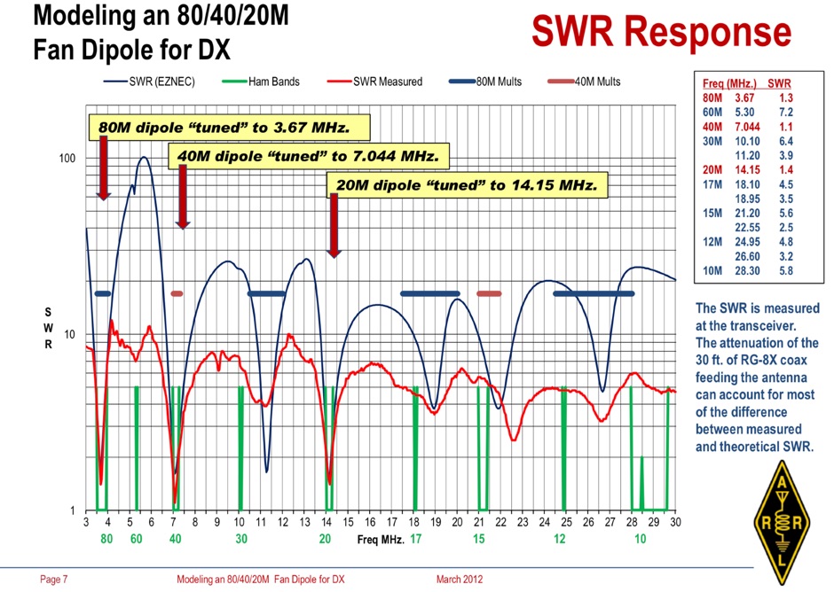 Operating an 80/40/20M fan dipole for DX is analyzed through EZNEC modeling, focusing on the antenna's performance in a real-world, low-height installation. The resource details the physical construction and SWR measurements of the fan dipole, comparing them against EZNEC simulations. It also incorporates High Frequency Terrain Analysis (HFTA) data to illustrate typical DX elevation angles for various regions from New England, providing a crucial context for evaluating antenna patterns. The analysis presents EZNEC-generated azimuth and elevation patterns for each band (80M, 40M, 20M) at specific frequencies, showing gain figures at different elevation angles relevant to DX propagation. It compares the modeled SWR with measured SWR, attributing discrepancies to coax attenuation. The study concludes with observations on the antenna's azimuth performance (omnidirectional within ±1.5 dB) and its less optimal elevation gain at desired DX angles, highlighting the impact of low antenna height on DX capabilities.
 -
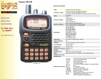 The Yaesu VX-5R, manufactured between 199x and 200x, offers a transmit frequency range covering 50-52 MHz, 144-146 MHz, and 430-440 MHz for European models, with US versions extending to 50-54 MHz, 144-148 MHz, and 430-450 MHz. Its receiver boasts an impressive wideband capability from 0.5 MHz to 999 MHz, with cellular frequencies blocked in some regions. The unit provides up to 5 watts RF output on 6 meters and 2 meters, and 4.5 watts on 70 centimeters, with selectable lower power settings down to 300 mW. This handheld transceiver utilizes a double conversion superheterodyne receiver system, featuring a 47.25 MHz first IF for FM and 45.8 MHz for WFM. Key specifications include a frequency stability of ±5 ppm across a wide temperature range and a current drain of 25-150 mA on receive. The VX-5R supports 220 regular memory channels with alpha tags, 3 home channels, and 10 NOAA weather channels, all stored in non-volatile EEPROM. Additional features include CTCSS/PL and DCS with tone search, ARS, ARTS, an internal voltmeter, and a Spectra-Scope. The device operates on a 7.2 VDC battery pack or 10-16 VDC external power, weighing 255 grams with dimensions of 58x88x27 mm. The VX-5R was also available as the metallic silver VX-5RS.
 -
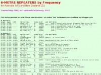 Presents a detailed compilation of **6-meter** voice repeaters operating within the 53-54 MHz segment across Australia (VK) and New Zealand (ZL), providing essential data for local and visiting radio amateurs. Each entry specifies the repeater's output and input frequencies, its assigned callsign (where applicable), the primary service area, current operational status (e.g., operational, under construction, scrapped), and a **Maidenhead grid locator**. The resource also includes the date the repeater was last heard or updated, offering insights into its recent activity. This listing is meticulously maintained by VK2KFJ, who updates entries based on personal observations and confirmed reports from other operators. It serves as a practical reference for hams seeking to utilize the 6-meter band for local communication via repeaters, particularly for those engaged in mobile or portable operations within the specified regions. The data helps operators configure their transceivers correctly for accessing these vital communication hubs. Beyond the repeater details, the page also notes common 6-meter FM voice simplex frequencies, such as the 52.525 MHz international call frequency, and lists historical packet simplex frequencies, though their current operational status is uncertain. This comprehensive approach ensures that operators have a broad overview of 6-meter activity in VK and ZL.
 -
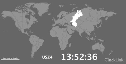 World Map - Time Zones realtime map allow to select and display current time for selected regions
 -
 MARC is dedicated to providing safe and reliable two-way radio communications for selected charity events in their respective regions
 -
 Broadcasts national and international programs locally and to all world regions in over 30 languages on mediumwave FM, TV, RealAudio/TV and on shortwave.
 -
 Broadcasts Bible teachings in 15 languages to all world regions on local media such as mediumwave, TV and FM, via international shortwave radio and Internet radio and TV.
 -
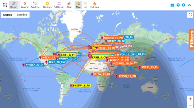 Monitoring real-time amateur radio activity is essential for DXers and contesters seeking rare contacts or tracking propagation. This online service aggregates DX spots from various **DX Cluster** networks, presenting them visually on a world map. Users can observe new spots as they appear, facilitating quick identification of active stations and potential openings. The platform offers filtering capabilities, allowing operators to narrow down displayed spots by specific bands such as 160m, 80m, 40m, 20m, 10m, and even VHF/UHF segments like 70cm and 23cm. Further refinement is possible by selecting the source continent of the spotter or the continent of the DX station, which assists in strategic operating. The service also includes a "Hot Now" list, highlighting currently active stations with recent spots. This dynamic display supports informed decision-making for pursuing **DX contacts** across different bands and geographical regions.
 -
 Yugoslavia's only external broadcast shortwave station; it broadcasts to all world regions in eleven languages.
 -
 Linux for shortwave and amateur radio monitoring. Supports popular SDR hardware and online streaming from KiwiSDR, WebSDR, and Spyserver sites. Articles about using Linux with your SDR devices.Skywave Linux, an innovative operating system, leverages cutting-edge technology for seamless access to radio signals globally. Ideal for regions with limited internet access, it effortlessly connects to a network of SDR servers, offering high-performance SDR operation without the need for extensive hardware. With pre-installed and configured SDR software, Skywave Linux simplifies signal discovery and operation for all users.
 -
 The _Sci.Electronics FAQ: Repair: RFI/EMI Info_ document, authored by Daniel 9V1ZV, provides a detailed analysis of computer-generated RFI/EMI, focusing on its impact on radio reception. It identifies common RFI sources such as CPU clock rates (e.g., 4.77 MHz to 80 MHz), video card oscillators (e.g., 14.316 MHz), and even keyboard microprocessors, all of which generate square-wave harmonics across HF and L-VHF regions. The resource outlines a systematic procedure for pinpointing RFI origins, including disconnecting peripherals and using a portable AM/SW receiver with a ferrite rod antenna to localize strong interference sources. The document categorizes RFI mitigation into shielding, filtering, and design problems, offering practical solutions for each. It recommends applying conductive sprays like _EMI-LAC_ or _EMV-LACK_ to plastic casings of radios, monitors, and CPUs to create effective Faraday cages, emphasizing proper grounding and avoiding short circuits. For filtering, the guide suggests using line filters, ferrite beads, and toroids on power and data lines, and small value capacitors (e.g., 0.01 uF for serial/parallel, 100 pF for video) to shunt RFI to ground. It also discusses the use of bandpass, high-pass, low-pass, and notch filters on the receiver front-end or antenna feed to combat specific in-band noise.
 -
 OKDX Foundation is a non profit organization the aim of which is organizing and funding radio amateur expeditions to rare countries and regions where no or low radio amateur activity exists.
 -
 The 160-meter amateur radio band, spanning 1.8 to 2 MHz, was historically the lowest frequency amateur allocation until the introduction of the 630-meter and 2200-meter bands. ITU Region 1 allocates 1.81–2 MHz, while other regions use 1.8–2 MHz. This band, often called "Top Band" or "Gentleman's Band," was established by the International Radiotelegraph Conference in Washington, D.C., on October 4, 1927, with an initial allocation of 1.715–2 MHz. Effective operation on 160 meters presents significant challenges due to the large antenna sizes required; a quarter-wavelength monopole is over 130 feet, and horizontal dipoles need similar heights. Propagation is typically local during the day, but long-distance contacts are common at night, especially around sunrise and sunset, and during solar minimums. The band experienced a resurgence after the LORAN-A system was phased out in North America in December 1980, leading to the removal of power restrictions.
 -
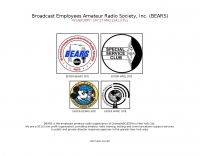 The Broadcast Employees Amateur Radio Society, Inc. (BEARS) operates an extensive network of **VHF and UHF repeaters** across New York, the Hudson Valley, Long Island, and New Jersey, accessible to all licensed amateur radio operators. This resource details the club's structure as a 501c3 tax-exempt non-profit, emphasizing its role in providing ham radio training, testing, and critical communications support to various public and private emergency response agencies. Key repeaters include W2ABC/RPT on 147.27 MHz with a 141.3 PL tone, serving as a central point for club activities and broader network access. BEARS is also a founding member of the **Disney Amateur Radio Interconnect (DARI)**, a consortium of open, linked VHF and UHF repeaters spanning major metropolitan areas such as Philadelphia, Baltimore/Washington DC, Orlando, Bristol, Los Angeles, and Boston. This interconnected system facilitates wide-area communication for members and supports emergency preparedness efforts across multiple regions. The club's focus extends beyond Disney employees, welcoming aspiring and current hams from outside the company to participate in its activities and utilize its robust repeater infrastructure.
 -
 The WAU award is issued by the "RadioAmator" magazine for contacts with amateur radio stations in all regions of Ukraine, cities of Kiev and Sevastopol made after 01.01.1993.
 -
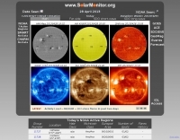 These pages contain near-realtime and archived information on active regions and solar activity
 -
 The Mississippi QSO Party, sponsored by the Mississippi Section of the ARRL, offers a prime opportunity for hams worldwide to make contact with Mississippi stations. This annual event encourages both in-state and out-of-state operators to activate Mississippi counties, promoting activity across the Magnolia State's diverse geographic regions. Participants often operate from various locations, including parks and historical sites, contributing to the unique character of the contacts. Operators typically utilize a mix of HF and VHF bands, employing CW, SSB, and digital modes to maximize their QSO count and multiplier acquisition. The exchange usually involves a signal report and county for Mississippi stations, or state/province/country for others. Results are compiled and published, recognizing top scorers in various categories and encouraging friendly competition among participants. The event serves as a significant annual gathering point for the Mississippi amateur radio community, fostering camaraderie and operational skill development.
 -
 Over 1900 ARISS school events have been conducted since 2000, facilitating amateur radio contacts between students and ISS crew members. This resource details the Amateur Radio on the International Space Station (ARISS) program, outlining scheduled contacts, operational procedures, and application processes for educational institutions worldwide. It lists specific upcoming contacts, such as those with Lewis Center for Educational Research in California and Vauban, Ecole et Lycée français de Luxembourg, typically operating on a 145.800 MHz downlink frequency. The content also provides crucial guidelines for radio amateurs, emphasizing the importance of not interfering with scheduled school contacts and utilizing the crossband repeater for general QSOs when available. It clarifies crew availability for casual contacts, noting that astronauts are usually free during personal time, approximately one hour after waking and one hour before sleeping, and often on weekends. Constraints on scheduling, such as avoiding EVA weeks and specific crew rest periods, are also detailed. Furthermore, the resource includes historical statistics on direct versus telebridge contacts, QSL information, and links to related ARISS, AMSAT, ARRL, and NASA websites. It also provides information on applying to host an ARISS contact for schools and youth organizations in various regions, including the United States, Europe, Africa, the Middle East, Canada, Central and South America, Asia, and Australia.
 -
-
 The Vintage Radio and Phonograph Society (VRPS) is a non-profit historical organization, incorporated in Texas, serving enthusiasts in the Dallas-Fort Worth area and surrounding regions. Its core mission revolves around the **preservation** and **restoration** of antique radios and phonographs, fostering a community for those with a general interest in early wireless technology and vintage audio equipment. The society actively supports the new radio/TV museum in Kilgore, TX, demonstrating its commitment to broader historical preservation efforts. Members engage in activities such as "Show and Tell" days, where they bring items for discussion, and participate in an annual convention. Events like the Spring Auction and the 2026 VRPS Convention, scheduled for October 23-25 at the Grapevine Convention Center, provide opportunities for members to connect, share knowledge, and acquire vintage pieces. The organization also highlights related events, such as the Houston Vintage Radio Association's 2026 convention.
 -
 RARA was founded in 1995 by a group of active amateur radio operators from several regions of the United States. Today, the club is international in scope with over 135 members around the world.
 -
 Low-frequency (LF) radio time signals, operating primarily in the 40–80 kHz range, are broadcast by national physics laboratories for precise clock synchronization. Transmitters like **JJY** (40 kHz, 50 kW; 60 kHz, 50 kW), RTZ (50 kHz, 10 kW ERP), MSF (60 kHz, 15 kW ERP), WWVB (60 kHz, 50 kW ERP), RBU (66.66 kHz, 10 kW), and DCF77 (77.5 kHz, 50 kW) cover vast geographic areas, often several hundred to thousands of kilometers. LF signals offer distinct propagation advantages over higher-band transmissions such as GPS. Their long wavelengths (3–6 km) enable effective diffraction around obstacles like mountains and buildings. The ionosphere and ground act as a waveguide, eliminating the need for line-of-sight and allowing a single powerful station to cover extensive regions. Ground wave propagation minimizes ionospheric variability effects on transmission delay, and signals penetrate most building walls effectively. Robust and low-cost receivers, often priced at 20–30 USD/EUR, are widely used in radio clocks. These receivers typically comprise a tuned ferrite core antenna, a receiver IC (e.g., Atmel T4227, U4223B, MAS1016) for amplification and AM detection, and a microcontroller for decoding the time signal and phase-locking a local clock. Specific components for DCF77, MSF, and WWVB are readily available from vendors like HKW Elektronik and Ultralink.
 -
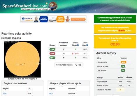 Real-time solar activity page at SpaceWeatherLive.com display sunspot regions, indicating sunspot numbers of with manitude class, Solar Flares and a list of daily events on the sun.
 -
 Of interest to solar keen hams is the YPOP section. Near real time movies of active solar regions in JAVA,GIF or MPEG.
 -
 The Black River Amateur Radio Club (K8BRC) operates as a central hub for amateur radio enthusiasts within Van Buren County, Michigan, and its adjacent regions. This organization facilitates various activities, including local nets, educational initiatives, and community service events, all aimed at promoting the hobby and enhancing operational skills among its members. The club's focus on local engagement ensures a strong sense of camaraderie and mutual support among hams, from those just earning their _Technician_ license to seasoned DXers. Members frequently participate in field operations and emergency communications drills, applying practical skills in real-world scenarios. The club also maintains resources for new operators, offering guidance on station setup, antenna theory, and operating procedures. Their commitment to public service is evident through participation in events requiring reliable communication. K8BRC provides a platform for hams to share knowledge, collaborate on projects, and engage in on-air activities, strengthening the local amateur radio community. Many members have achieved **100** DXCC entities.
 -
 The Salvation Army Team Emergency Radio Network (SATERN) is a vital resource for amateur radio operators involved in emergency communications. This network facilitates the coordination of communication during disasters, ensuring that vital information can be relayed effectively. SATERN operates through a series of nets that connect operators across various regions, allowing for real-time updates and support during emergencies. Participation in SATERN not only enhances your skills as an amateur radio operator but also contributes to community resilience. Operators are trained to handle emergency traffic and provide assistance to those in need. By joining SATERN, you become part of a dedicated team that prioritizes safety and communication in times of crisis. The network encourages regular participation in drills and training sessions to ensure readiness when real emergencies arise.
 -
 Documents the XR0ZR DXpedition to Juan Fernandez Island (SA-005) in November 2013, providing insights into activating a highly sought-after DXCC entity. The team's efforts focused on maximizing QSO opportunities across various bands and modes, a critical aspect for stations aiming to complete their DXCC or IOTA awards. Operating from a remote location like Juan Fernandez presents unique logistical and technical challenges, which the expedition successfully navigated to put this entity on the air for thousands of eager DXers worldwide. The resource outlines the operational period, the callsign XR0ZR, and the specific island group activated. Such DXpeditions are vital for the global amateur radio community, enabling hams in less accessible regions to achieve their award goals and fostering international communication. The detailed account serves as a historical record of a significant activation.
 -
 The Hurricane Watch Net (HWN) is an amateur radio organization dedicated to serving the National Hurricane Center and the public since 1965. It plays a crucial role in disseminating real-time tropical weather information for the Atlantic and Eastern Pacific regions. The HWN operates during hurricane events, providing updates and facilitating communication among amateur radio operators and emergency services. This network is essential for ensuring that communities are informed and prepared for severe weather conditions. In addition to its operational role, the HWN offers educational resources and outreach programs aimed at enhancing public awareness about hurricane preparedness. This includes providing access to tracking maps, storm surge information, and safety guidelines. The HWN encourages amateur radio operators to participate in its activities, fostering a spirit of community and collaboration in the face of natural disasters. By subscribing to their email updates, individuals can stay informed about active storms and receive vital safety information.
 -
 Vertical antenna tests at the Sonten-Rancabali tea resort in Ciwidey, West Java. The assembly, led by Mr. Dian Kurniawan and the team, took just 20 minutes. Mrs. Mita performed the transmit check-in test, which was received across various regions in Indonesia, including Sulawesi, East Java, and Bangka Belitung. The team will release a video of the test soon and has thanked colleagues YB3HRY and YB0BAW for their reports.
 -
 The IARU Region 2 has established this voluntary band plan to better organize the use of our bands efficiently. To the extent possible, this band plan is harmonized with those of the other regions.
 -
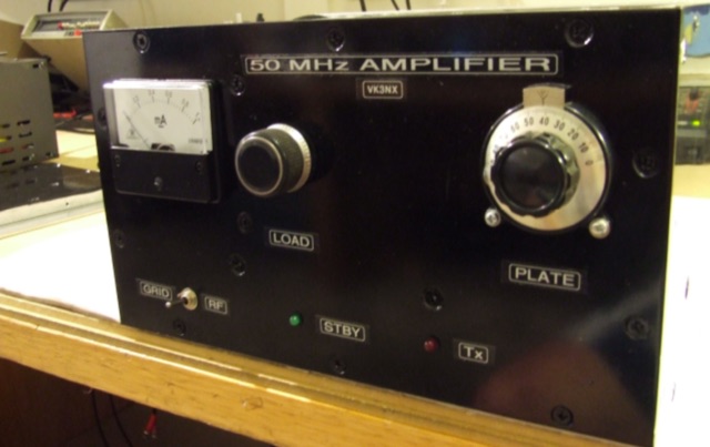 This project addresses the need for a 50 MHz Amplifier providing substantial power for Australian "Advanced Licensees" permitted to use 400W PEP in the 52-54 MHz band. In regions limited to 100W PEP due to TV channel usage, this initiative aims to enhance power output for transceivers with lower capabilities on the 6m band.
 -
 The article discusses the use of SDR# (SDR SHARP) software for SDR receivers, highlighting its Band Plan feature that visually represents RF spectrum allocations. The author modified SDR# to display detailed IARU HF band plans, creating three XML files for different IARU regions. These files include various operational modes and specific frequency allocations. Despite potential errors, the modifications aim to enhance the usability of SDR# for ham radio operators. The article includes references and download links for the XML files and IARU band plans.
 -
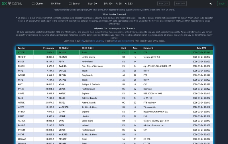 DX Data provides a unified view of real-time DX spots, aggregating data from **DXSpider**, the **Reverse Beacon Network (RBN)**, and PSK Reporter. This online service offers advanced filtering capabilities, allowing amateur radio operators to refine spot displays by DXCC entity, band, mode, CQ zone, and continent. It addresses the challenge of sifting through numerous DX spots by presenting a consolidated stream, enabling DXers to efficiently identify active stations across various bands and modes. The platform integrates with Club Log, which assists in fine-tuning band-entity combinations based on a user's logging history, thereby reducing irrelevant spot noise. Key features include DX email alerts, PSK Reporter tracking, and a custom watchlist for monitoring specific stations or regions. The service also incorporates a live news feed from DX World, providing current information relevant to the DXing community. This design aims to streamline the DX spotting process, offering a responsive interface for identifying operating opportunities.
 -
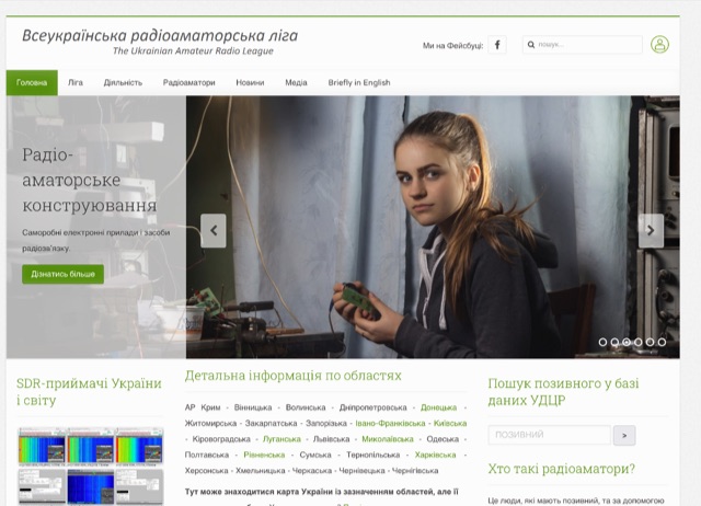 The Union of non-governmental organizations "The Ukrainian Amateur Radio League" (UNGO "UARL") was founded in December of 2015. Currently, there are about 1500 members in the League, representing most regions and cities of Ukraine.
 -
 Approximately 100 MeshCom nodes are visualized in real-time on a geographical map, providing a dynamic overview of the LoRa mesh network. This resource, hosted by _OE1KFR_, details node positions, telemetry data, and message traffic. Users can measure distances between two selected nodes, view text messages with callsign, destination, and gateway information, and access position data including latitude, longitude, and altitude. The platform supports filtering by regions such as Europe, USA, and Asia, allowing operators to focus on specific geographical areas. The detailed node list table presents comprehensive status information for each node, including gateway callsign, firmware version, hardware type, and environmental telemetry like temperature, pressure, humidity, and CO2 levels. This granular data enables operators to monitor network health and individual node performance, facilitating troubleshooting and optimization of MeshCom deployments. The map interface enhances situational awareness for those engaged in LoRa mesh networking.
 -
 This document serves as a reference guide for pilots interpreting the symbols used on Instrument Flight Rules (IFR) Enroute Low and High Altitude Charts for both the United States and Alaska. It focuses on six key categories of information critical for safe IFR navigation and it includes a section dedicated to Oceanic Route Charts for the North Atlantic and North Pacific regions.
 -
 This document serves as a thorough guide to amateur radio nets throughout Australia and includes some international (DX) nets. It outlines key information like frequencies, schedules, and the people responsible for managing these nets. Among the nets covered are Ron's 10 A.M. net, the Australian Travellers Net, and several others, each operating on different bands and regions. Additionally, it offers technical details about repeaters, such as frequency, offset, and CTCSS tones where applicable. Any updates are clearly marked, and further details are included for linked repeater systems and network connections.
 -
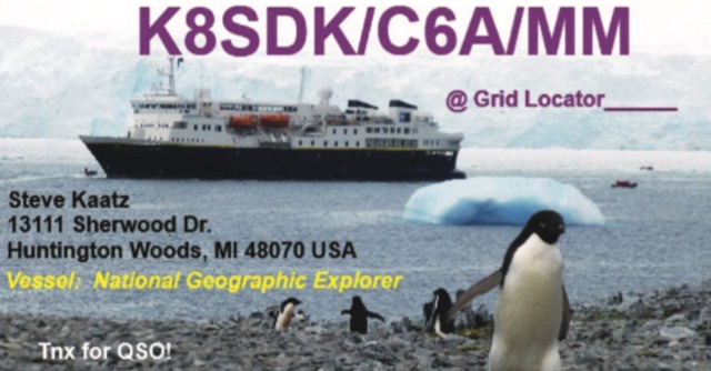 This **PDF report** documents a _maritime mobile_ DXpedition operating from the _Southern Ocean_ near Antarctica, detailing antenna deployment strategies on a sailing vessel. It addresses power management systems for remote operations and propagation characteristics specific to polar regions on **20m and 40m** bands. Operational strategies include managing high-density pileups using split frequency operation and maintaining signal integrity during periods of high aurora activity. Equipment considerations cover specific transceiver models like the Icom IC-7300, antenna types optimized for marine vessel installation, and battery power systems for extended periods without shore power. The resource also examines the use of satellite communication for real-time log uploads and QSL confirmation from remote locations, and discusses mitigating signal degradation from ice accumulation on antennas. DXZone Focus: PDF report | Maritime Mobile DXpedition | Polar Propagation | Split Frequency Operation
 -
 This article examines how geomagnetic activity influences 160-meter radio propagation. K9LA analyzes observations of enhanced signals preceding K-index increases. Modeling shows that as ionospheric electric fields rise from 0 to 75 mV/meter during early geomagnetic storms, they create an electron density valley above the E region, enabling signal "ducting" between the E and F regions. This effect vanishes at higher field strengths (100 mV/meter). The phenomenon may explain both exceptional 160m openings preceding 6m propagation and possibly Marconi's contested 1901 transatlantic reception, which occurred during a small geomagnetic disturbance.
 -
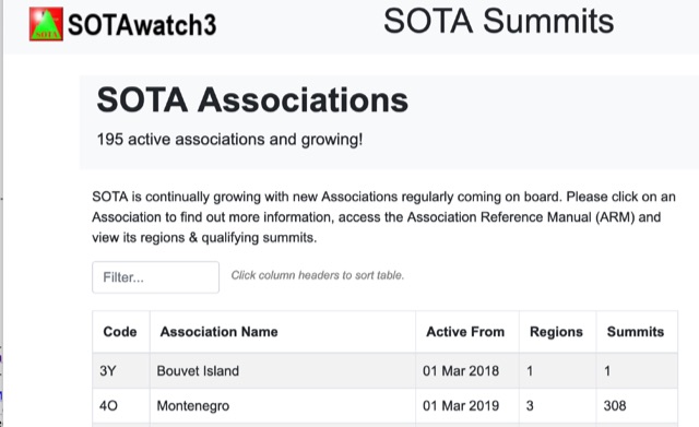 SOTA is continually growing with new Associations regularly coming on board. Click on an Association to find out more information, access the Association Reference Manual (ARM) and view its regions and qualifying summits.
 -
 AM radio listening excels at night due to sky-wave propagation, where signals travel farther by reflecting off the ionosphere’s F1 and F2 regions. Daytime ground wave propagation falters as solar radiation ionizes the D region, absorbing signals. At night, reduced ionization allows recombination, letting waves reach hundreds of miles. This enables tuning into distant stations, like KGO in San Francisco from Northern California. Enhanced by tools like the CCRadio-2E, sky-wave propagation turns AM listening into an exciting nocturnal adventure.