Search results
Query: weather
Links: 183 | Categories: 9
-
 Amateur TV, Satellite TV Equipment, Broadband Via Satellite, Weather Monitoring
 -
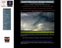 Providing real-time weather spotter reports for the following counties: Delaware, Fairfield, Fayette, Franklin, Hocking, Licking, Madison, Pickaway, Ross and Union.
 -
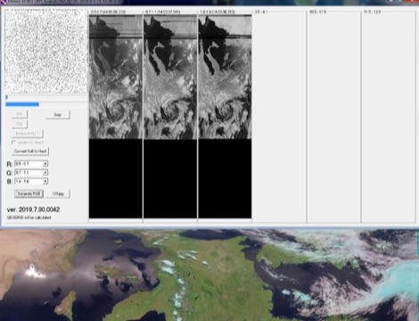 A portable decoder for METEOR M weather satellite LRPT signal, available for windows and Linux
 -
 The Hurricane Watch Net, Amateur Radio Serving the National Hurricane Center Since 1965. The HWN provides up to date tropical weather information for the Atlantic and Eastern Pacific. Subscribe for tropical weather email.
 -
 A private-public partnership with three main goals to collect weather data contributed by citizens; to make these data available for weather services and homeland security; and to provide feedback to the data contributors so that they have the tools to check and improve their data quality
 -
 The calculator designs the Yagi-Uda antenna based on the DL6WU model with boom correction, following the G3SEK-DL6WU method. It optimizes the antenna for maximum gain and allows adjustment of passive elements without affecting SWR. DL6WU antennas are known for their high gain, minimal sensitivity to nearby objects, and stable performance in various weather conditions.
 -
 Amateur radio club serving the Concho Valley of West Texas for over 70 years providing public service and SKYWARN severe weather spotting service to the National Weather Service.
 -
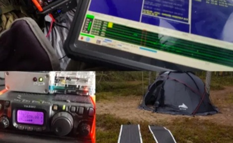 Operating a QRP station in frigid conditions presents unique challenges, particularly concerning power management and equipment reliability. This resource outlines a specific winter portable configuration, focusing on maintaining operational capability when temperatures drop significantly. It details the use of a _Yaesu FT-817ND_ for digital QRP modes, paired with a _Raspberry Pi_ for digital signal processing and logging, demonstrating a practical approach to cold-weather field communications. The article provides insights into selecting appropriate power sources, such as LiFePO4 batteries, and managing their performance in sub-zero environments. It also covers shelter considerations, including tent selection and heating strategies, crucial for operator comfort and equipment protection during extended activations. The author, _OH8STN_, shares firsthand experience from Arctic Circle operations, emphasizing robust gear choices. Further content includes a video walkthrough, illustrating the physical setup of the station, antenna deployment, and the overall operational workflow in a winterized environment. This visual aid complements the written text, offering a comprehensive view of the entire portable station, from the transceiver to the power system and the protective shelter.
 -
 Accurate meteorological data is crucial for optimizing antenna performance, predicting propagation, and ensuring safe tower work. This resource provides a curated inventory of weather stations, including models like the _AcuRite Atlas_ with lightning detection and the _Ambient Weather WS-2902_ WiFi Smart Weather Station, which offer real-time data on environmental factors. The product listings detail specific features such as direct-to-Wi-Fi connectivity, rainfall tracking, and temperature insights, enabling informed decision-making for various amateur radio operations. The platform categorizes products by application, featuring weather stations tailored for home and backyard use, as well as more robust systems for farm and agriculture, which can be critical for field day operations or remote station monitoring. It also highlights _Made in USA_ options, emphasizing local manufacturing and support. Beyond weather instruments, the site also presents related surveillance technology, such as the _Waggle solar CCTV camera_, designed for outdoor reliability with an IP65 weatherproof rating. This integration allows for comprehensive monitoring of remote ham radio shacks or antenna sites, combining environmental data with visual oversight.
 -
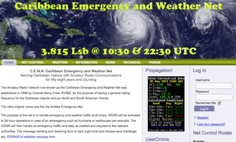 The Amateur Radio network now known as the Caribbean Emergency and Weather Net was established in 1958 by Colonel Henry Frew, KV4BZ, for the purpose of having a general calling frequency for the Caribbean Islands and our North and South American friends.
 -
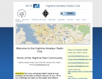 Details the Highline Amateur Radio Club (HARC), an organization dedicated to public service through Amateur Radio and community engagement for radio enthusiasts. The club conducts a monthly general meeting on the 4th Saturday at 10 AM at Burien Fire Station 28. HARC also hosts a weekly net on Tuesdays at 7:30 PM, operating on **146.660 MHz** with a -600 kHz offset and a 103.5 Hz **CTCSS tone**. Additionally, members gather for a weekly breakfast on Fridays at 9:30 AM at Tuscany at Des Moines Creek. The resource provides current weather conditions for Burien, WA, displaying temperature, wind chill, and a three-day forecast from the National Weather Service Seattle/Tacoma Office. It also links to the latest ARRL Newsletter, noting a system breach in May 2024 affecting archived links. The club's activities include regular meetings, on-air nets, and social gatherings, supporting local amateur radio operations and community involvement.
 -
 DXLook is a free, web-based propagation platform that delivers comprehensive, real-time insight into HF and VHF conditions directly from any modern browser. It aggregates live spots from PSK Reporter, WSPRnet, RBN, and DX Cluster, complemented by NOAA space-weather metrics such as SFI, K/A indices, and geomagnetic alerts. Integrated VOACAP predictions allow practical "theory versus reality" comparisons, while the interactive world map with filters, gray line, and grid overlays enhances situational awareness. With no installation or maintenance required, DXLook provides a convenient, accurate, and accessible solution for everyday operating and propagation analysis.
 -
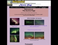 A source for Information, links and images about the "Northern Lights" on-line since the Web began
 -
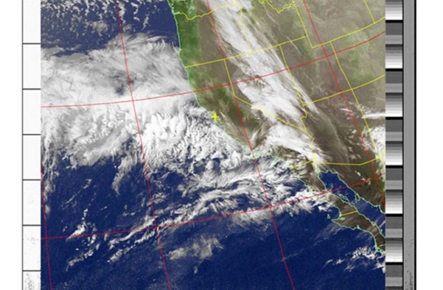
 How to receive NOAA weather satellite with a home made QFH Antenna. This project includes some easy and efficient notch filters to suppress noise from FM frequencies
 -
 Northern Michigian Amateur Radio Club Inc. was founded on the principles of providing services to the local area Amateur Radio Service Groups and to public.This group of license amateur radio operator provide Emergency Communication during the time of weather related,disasters and man made emergencies.
 -
 Demonstrates the practical application of APRS (Automatic Packet Reporting System) through the lens of HB9PVI's activities in Switzerland. It covers the system's core function of reporting geographical positions and telemetry data from various objects, including mobile stations, aircraft, and the ISS, distributed via packet radio and internet gateways. The resource highlights the routing paradigm shift introduced in April 2005, specifically the recommendation to use _WIDE1-1_ instead of RELAY and WIDE for digipeating to reduce duplicate packets. The page presents real-time maps displaying the positions of amateur radio stations in Switzerland and around Bern, updated every few minutes. It details specific callsigns like _HB9BA-2_ (HB9PVI's home QTH), _HB9BA-8_ (a weather station), and _HB9BA-4_ (a WIDE digipeater on Weissenstein mountain), providing context for their roles within the local APRS network. Links to track HB9PVI's mobile operations (_HB9PVI-9_) and handheld devices (_HB9PVI-15_, _HB9PVI-7_) are also provided. Furthermore, the resource curates a list of APRS software options for various operating systems, including _JavAPRS_ for Europe, _UI-view_, and _X-Astir_ for Linux, alongside digipeater/IGATE software like _DiXPRS_. It also offers downloadable APRS information, including a PDF article by HB9PVI and HE9ZGN, and a PowerPoint presentation in German, making it a repository of practical and historical APRS data.
 -
 A Dutch website dedicated to weather satellite reception with many documents related to antennas, software and techniques on receiving signals from weather satellites.
 -
 The "DIY Telescopic-V Antenna £35" project showcases the creation of a budget-friendly, portable telescopic V-shaped antenna inspired by commercial designs. Using eBay-sourced telescopic whips and custom mounting solutions, the author documents their process, testing, and adaptations. Despite challenges like weather and missing tools, the antenna performed well across multiple bands, enabling successful QSOs. Future improvements include exploring loading coils and testing in better locations. The compact design offers versatility for amateur radio enthusiasts seeking an affordable and practical solution.
 -
 Aeronautical communications products, radio communications, weather systems
 -
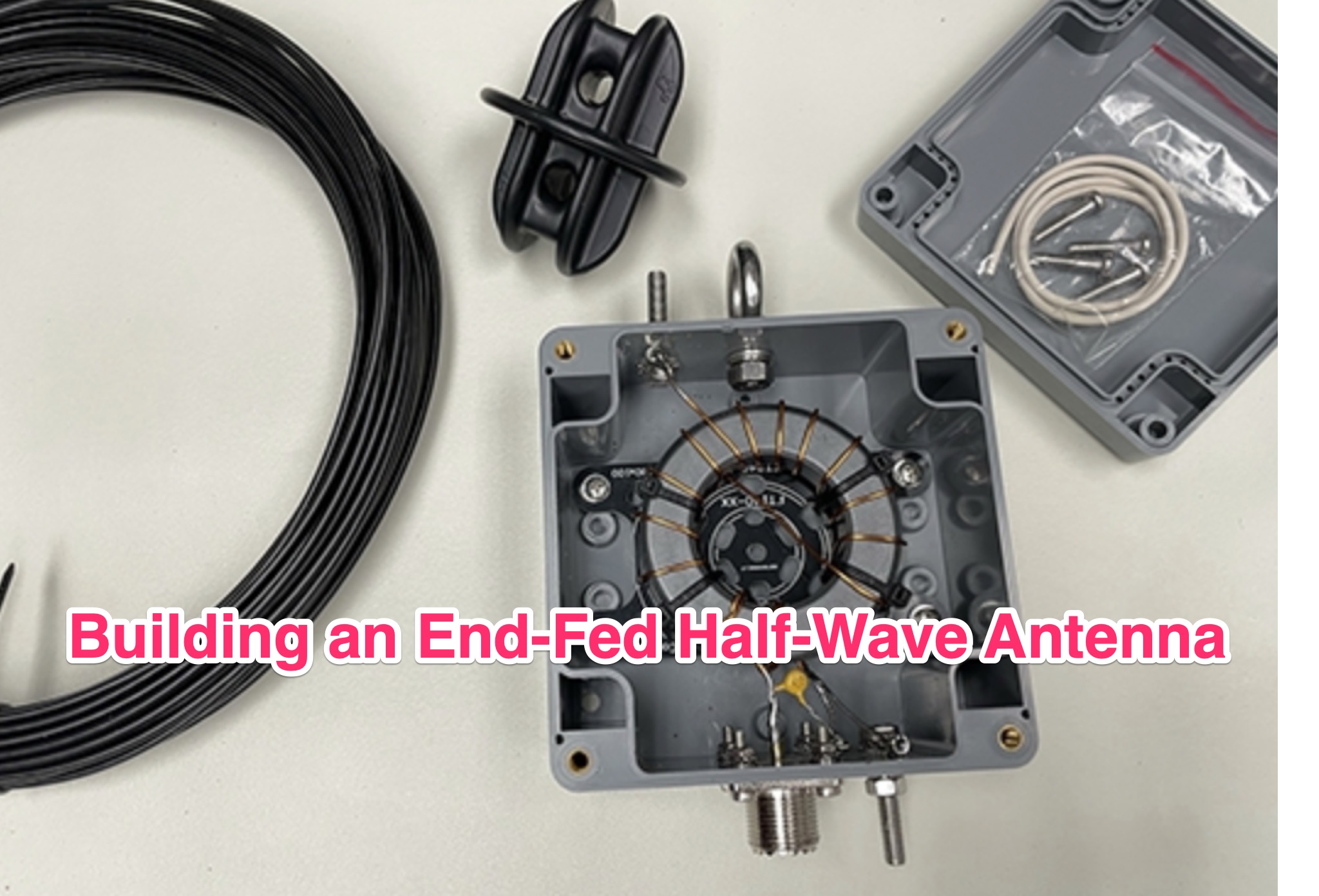 The ARRL's End-Fed Half-Wave (EFHW) Antenna Kit is an easy-to-build four-band antenna designed for 10, 15, 20, and 40 meters. Ideal for portable operations, it includes a 49:1 impedance transformer for compatibility with most transceivers. This project, detailed with step-by-step assembly instructions, involves creating a weatherproof enclosure and impedance matching network. The kit simplifies HF operations and supports multiple configurations, making it a versatile tool for amateur radio opertors.
 -
 The Pickens County Communications Group are volunteers for the Pickens County Emergency Management Agency in Pickens, S.C. and members of R.A.C.E.S.-Radio Amateur Civil Emergency Service, with the South Carolina State Guard. We are not a club. We are a group of amateurs radio enthusiasts with similar interests, dedicated in providing emergency communications for public service, public safety, and commercial communications for local agencies. We also provide Skywarn communications for Pickens County and the National Weather Service in Greer, S.C.
 -
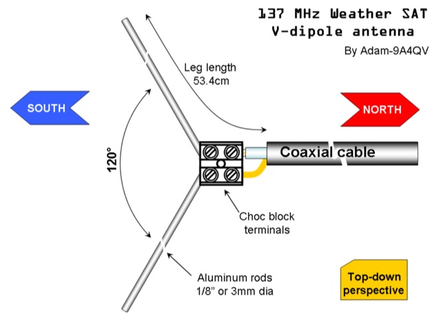 The DIY 137 MHz WX SAT V-dipole antenna project details the construction of a specialized antenna for receiving weather satellite transmissions. It provides specific dimensions for the dipole elements, designed for optimal reception around the 137 MHz band, which is commonly used by NOAA and Meteor weather satellites. The resource outlines the materials required, such as aluminum tubing for elements and PVC for the support structure, along with the necessary coaxial cable and connectors. The article presents a clear, step-by-step assembly process, including how to form the V-shape and connect the feedline. It emphasizes practical considerations for mounting and weatherproofing the antenna for outdoor deployment. The design focuses on simplicity and effectiveness for amateur radio operators interested in satellite imagery. Key aspects include the precise angle of the V-dipole and the lengths of the radiating elements, which are critical for achieving the desired circular polarization response for satellite signals. The resource includes photographic documentation of the construction phases and the final mounted antenna.
 -
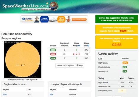 Real-time solar activity page at SpaceWeatherLive.com display sunspot regions, indicating sunspot numbers of with manitude class, Solar Flares and a list of daily events on the sun.
 -
 If you want to have a closer look at the weather, you can download software and visually display data.
 -

-
 The CobWebb antenna project is a compact, multiband HF solution ideal for amateur radio operators. Covering 14-28 MHz, it features a square dipole array with near-omnidirectional coverage and unity gain. This guide details a DIY approach, using a 1:4 current balun for impedance matching. Construction involves aluminum and fiberglass tubing, with optimized element tuning for SWR performance. Weather resistance improvements and resonance shift considerations are also discussed. Build your own CobWebb antenna for an efficient, space-saving HF experience.
 -
 Messi & Paoloni offers a range of RF coaxial cables, including the _Ultraflex_ series, specifically engineered for amateur radio applications. These cables feature advanced dielectric materials and high-density braiding, resulting in significantly reduced attenuation across HF, VHF, and UHF bands. For instance, the Ultraflex 7 exhibits a loss of only **2.5 dB per 100 feet** at 144 MHz, making it suitable for demanding DX and contesting operations. The company's product line also includes specialized connectors, such as N-type and PL-259, designed to maintain optimal impedance matching and minimize signal reflections. Each connector is precision-machined to ensure a secure, weather-resistant termination, crucial for outdoor antenna installations and long-term reliability. Messi & Paoloni emphasizes rigorous quality control, with all cables undergoing testing to ensure consistent performance and durability, supporting effective two-way radio communication.
 -
-
 List of global weather fax (HF fax) stations, including their locations, call signs, and frequencies. Click on any station's call sign to view its weatherfax broadcast schedule. This site provides various radiofax receiver manuals in PDF format, on the Receivers page.
 -
 The Bazooka antenna, a coaxial dipole, functions as an omnidirectional antenna with vertical or horizontal polarization. Patented in 1939 and refined in 2006, it features a quarter-wavelength coaxial cable with separated conductors. The outer conductor connects to a sleeve, while the inner conductor extends vertically. Initially complex, it has been simplified for versatile use, including military applications. Adding elements can modify its behavior for NVIS or Yagi-Uda configurations. Experiments in 2007 at the Campus de Pesquisas GeofÃsicas in Paula Freitas-PR demonstrated consistent VHF and UHF performance, showing reliable return loss measurements despite variable weather.
 -
 Small company based in Santa Maria, California, designing and manufacturing electronic products for amateur radio, education, and commercial users. Product line includes APRS devices for real-time vehicle tracking, weather monitoring, and remote telemetry, as well as the ADS-SR1 Simplex Repeater, the ADS-WS1 Weather Station, the SSTVCAM slow-scan TV camera, and GTRANS protocol translator for Garmin FMI.
 -
 Receiving & Decoding NOAA Weather Satellites using a simple rtl-sdr dongle, a helix antenna and a Windows PC
 -
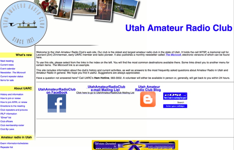 The Utah Amateur Radio Club (UARC), holding the callsign _W7SP_, provides a comprehensive resource for amateur radio operators, particularly within Utah. It details club activities such as Field Day, Winter Field Day, and annual social events like the Steak Fry and Christmas Dinner. The site also lists club resources including repeaters, _IRLP_ information, HF remotes, and a lending library. Information on becoming a ham, exam schedules, and a local repeater list are also available, catering to both new and experienced operators in the region. UARC hosts regular meetings on the second Thursday of each month, excluding July and August, at the University of Utah's Warnock Engineering Building, with presentations on topics like weather and _Skywarn_. The club publishes the monthly _Microvolt_ newsletter and maintains a YouTube channel for meeting playback. Additionally, UARC offers a Ham Hotline for questions and provides access to an "Elmer" list for mentorship, supporting the local amateur radio community.
 -
 Examines Teledyne Cable Solutions' offerings, focusing on their engineered solutions for demanding cable applications. The resource details their capabilities in designing and manufacturing _multi-core cable_ and ruggedized assemblies, emphasizing their integrated approach within Teledyne Marine. It covers the technical aspects of their products, which are tailored to specific operational environments and performance requirements, ensuring reliability in challenging situations. The content highlights the practical application of their cable solutions across various industries, including those requiring robust interconnectivity for remote sensing or communication systems. It implicitly suggests how these specialized cables, designed for high performance and durability, could benefit amateur radio operators seeking reliable feedlines or control cables in extreme weather or portable operations, potentially offering superior signal integrity and mechanical strength compared to standard offerings. The company's focus on custom solutions distinguishes its approach.
 -
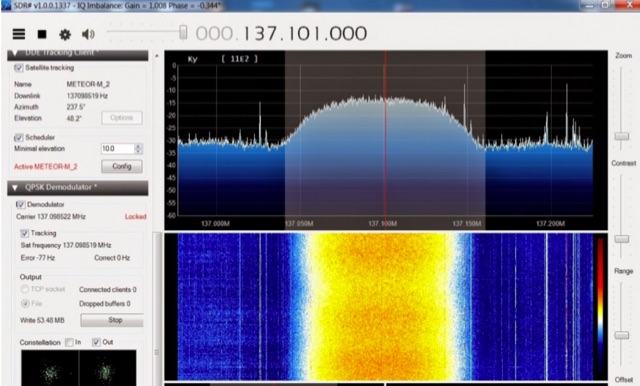 The Meteor-M N2 is a polar orbiting Russian weather satellite that was launched on July 8, 2014. Its main missions are weather forecasting, climate change monitoring, sea water monitoring/forecasting and space weather analysis/prediction. Meteor-M N2 transmits images using the digital LRPT protocol at around 137.1 MHz with can be received with an RTL-SDR.
 -
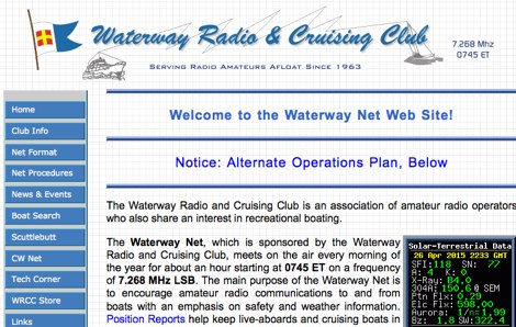 The Waterway Net, sponsored by the Waterway Radio and Cruising Club, is dedicated to enhancing amateur radio communications for recreational boaters. Meeting daily at 0745 ET on 7.268 MHz LSB, the net focuses on safety and weather updates, providing a vital link for live-aboards and cruising boats to stay connected with families and friends. Position Reports and Float Plans are essential components that ensure safety for offshore passage makers. Established in the early sixties, the Waterway Net is one of the longest-running nets in amateur radio history. Open to all amateur radio operators with a General class license or higher, it encourages participation without requiring WRCC membership. Newcomers are advised to listen initially to understand net procedures before checking in. In emergencies, FCC regulations allow anyone, licensed or not, to use any frequency to call for help, with the 20-meter frequency of 14.300 MHz available for emergency assistance approximately eighteen hours a day.
 -
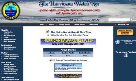 The Hurricane Watch Net (HWN) is an amateur radio organization dedicated to serving the National Hurricane Center and the public since 1965. It plays a crucial role in disseminating real-time tropical weather information for the Atlantic and Eastern Pacific regions. The HWN operates during hurricane events, providing updates and facilitating communication among amateur radio operators and emergency services. This network is essential for ensuring that communities are informed and prepared for severe weather conditions. In addition to its operational role, the HWN offers educational resources and outreach programs aimed at enhancing public awareness about hurricane preparedness. This includes providing access to tracking maps, storm surge information, and safety guidelines. The HWN encourages amateur radio operators to participate in its activities, fostering a spirit of community and collaboration in the face of natural disasters. By subscribing to their email updates, individuals can stay informed about active storms and receive vital safety information.
 -
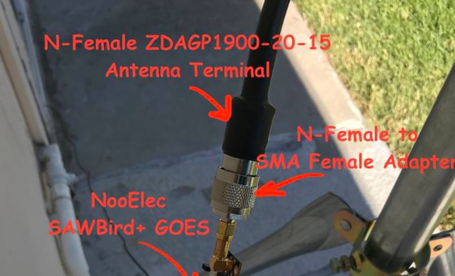 Receiving **GOES-16** and **GOES-17** weather satellite imagery requires a specific hardware and software configuration, detailed in this practical guide. The author outlines the necessary components, including a Raspberry Pi, an RTL-SDR dongle, a suitable LNA with SAW filter for 1.69 GHz, and a parabolic grid antenna. This setup enables direct reception of high-resolution weather data, a fascinating aspect of amateur radio satellite operations. The installation process begins with preparing the Raspberry Pi, followed by updating the system and installing essential dependencies like `git`, `build-essential`, and `cmake`. A critical step involves compiling and installing `librtlsdr` from source, ensuring proper driver setup and blacklisting conflicting DVB drivers. The guide then walks through testing the RTL-SDR dongle to confirm device recognition and troubleshoot common issues like USB power or driver installation problems. Finally, the instructions cover cloning and building `goestools`, a software suite essential for processing the satellite signals. This compilation, while time-consuming on a Raspberry Pi, is crucial for decoding the raw data into usable imagery. The guide concludes with the initial steps for creating the `goesrecv.conf` configuration file, preparing the system for active satellite reception.
 -
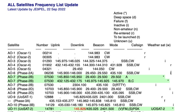 All Satellites Frequency List Update. A complete list of satellite frequencies available in several formats, including info on Satellite Uplink and Downlink frequencies Beacon, operative Mode, Callsign and Weather sat functionality.
 -
 2E0RDj Amateur Radio Station in Beachley, Nr Chepstow. IO81QP. Projects, Radio & Weather.
 -
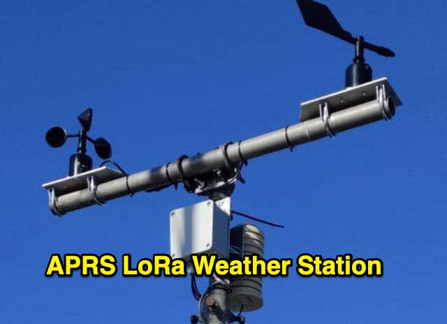 The weather station described here uses a TTGO v3 1.6.2 module and various sensors. It displays the data on an OLED screen and transmits them among a choice of protocols to the APRS, APRS-IS, Wunderground servers or via an MQTT broker. APRS data is transmitted on 433.775 MHz (can be changed) using the LoRa protocol. APRS beacons picked up by iGate gateways are then transmitted to APRS servers.
 -
 A collection of dynamically produced images based on the daily data of the NOAA Space Weather Prediction Center
 -
 The U01 emergency communications antenna is a versatile, multiband antenna designed for 80/60/40/20/17/15/10m bands, known for its reliability and compact size. It features a broadband transformer wound on various core options like FT82-43, FT114-43, or FT140-43, with the latter capable of handling up to 100W. The antenna incorporates a PCB with options for SMA and BNC connectors, and a weather-proofed design for durability. The lightweight construction, using materials like DX Wire UL and Polyester rope, makes it highly portable. The antenna's design has been tested and proven within the DARC Chapter U01, with multiple build options and detailed documentation available for DIY enthusiasts.
 -
 Hamradio_copilot is an open-source tool designed for DXers and contesters who need real-time situational awareness. It is ideal for operators who want to visualize propagation trends instantly rather than scrolling through raw text streams of cluster spots. Rally acting as a copilot for your station, this tool transforms raw data into actionable intelligence. By visualizing Signal-to-Noise Ratios (SNR) across different bands, it helps operators make quick decisions on which band to prioritize or where to point their antennas, effectively showing not just who is on air, but where the propagation is currently open from your location. This is a fantastic information for avid contesters. The software aggregates data from two primary services: - Reverse Beacon Network (RBN) via Telnet. - PSK Reporter via MQTT feeds. It processes this data to generate a comprehensive HTML report featuring SNR heatmaps and statistical breakdowns by ITU Zone. Users can filter data by specific zones or country codes (ADIF), analyze historic time ranges, and optionally integrate solar weather data. The complete source code is available on GitHub, allowing for community customization. It is written in Python and uses SQLite for data management.
 -
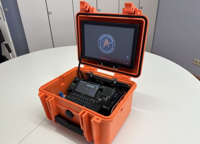 This project details the creation of a portable GoBox housing an IC705, Windows 11 PC, and Bluetooth microphone. The robust setup, enclosed in a weatherproof Hofbauer Explorer Case, ensures stability and functionality for QRP and emergency radio activities. The aluminum-mounted devices minimize RF interference, and a built-in LifePO4 battery powers the 10.1 TFT touch LED monitor, providing approximately 12 hours of use in receive mode. With a focus on grab-and-go versatility, this GoBox stands as an efficient solution for outdoor ham radio operations.
 -
 An online database featuring current and historical weather balloons, complete with a fully searchable archive that can be filtered by launch site. The integrated map shows both the current and historical trajectories of radiosondes, from their launch points to their final landing positions.
 -
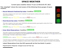
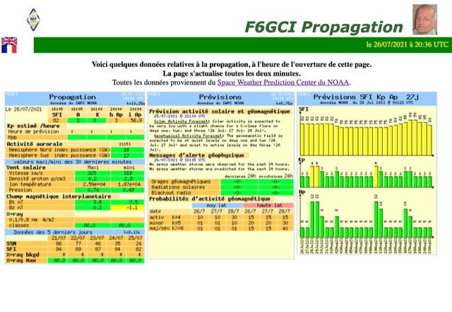
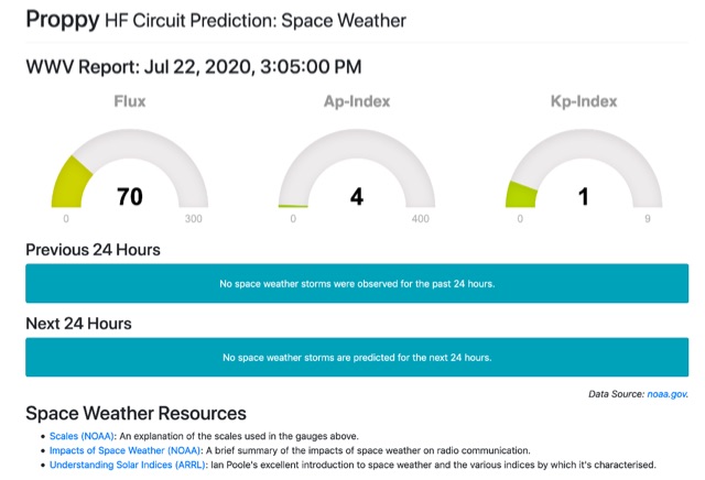 Current space weather condition gauges, with solar indices taken from the latest WWV report
 -
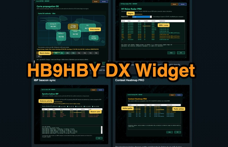 Demonstrates the _Widget DX HB9HBY_ software, a compact desktop application for amateur radio operators, providing essential real-time information. The widget displays UTC time, current HF propagation conditions, local weather, and thunderstorm risk. It also integrates radio-related links and offers advanced PRO functions, such as a DX map, HF noise radar, IBP beacon synchronization, contest heatmap, aurora radar, and a rare DX radar. The software is available for Windows 10/11 and Linux, with a macOS version planned for future release, and supports both French and English interfaces. Author HB9HBY highlights the widget's simple installation process and automatic update capabilities, which can be silent for minor fixes or include notifications for significant changes. The free version provides core functionalities, while a 15-day free trial unlocks the PRO features. A lifetime PRO license is available for a one-time payment of CHF 10, activating advanced tools that help operators make quicker decisions at the station by correlating propagation, UTC, DX activity, and local conditions, though results remain indicative and require confirmation via listening or tools like _RBN_ or _PSKReporter_.
 -
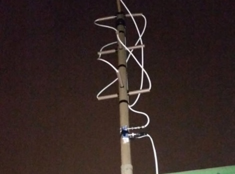
 The article describes the construction of a Lindenblad antenna, which is well-suited for receiving signals from low-orbiting weather satellites. The key points are: The Lindenblad antenna has an omnidirectional horizontal radiation pattern and is optimized for low to medium elevation angles, making it ideal for tracking passing satellites near the horizon. It is designed to receive circular polarization, which is common for weather satellite signals. The antenna is constructed using 4 folded dipole elements arranged on a cross-shaped frame. The necessary materials include a plastic junction box, PVC tubing, and aluminum rods to form the dipole elements. The article provides detailed instructions for preparing the components, assembling the dipoles, and connecting the feed lines to create the complete antenna. The completed antenna can be mounted on a vertical support, with the dipole elements angled at 30 degrees from horizontal, to optimize reception of the passing satellites. The author notes that the design was originally published in a now-defunct magazine, Meteo Satellite Inf", in 1993
 -
 This DIY homebrew project provides a durable, weatherproof center connector for dipole antennas, ideal for HF setups like 40m wire dipoles or inverted-V designs. Made from PVC pipe and an SO-239 UHF connector, it ensures strong support and room for a current balun. With simple drilling and assembly, it offers a cost-effective alternative to commercial options. Perfect for amateur radio operators, this dipole antenna connector enhances performance while keeping costs low. A great solution for DIY antenna builders seeking reliability and longevity.