Search results
Query: tracking
Links: 184 | Categories: 13
Categories
- Software > Awards tracking
- Operating Modes > Satellites > Real Time Tracking
- Software > Satellite tracking
- Radio Scanning > Aeronautical
- Software > Antenna rotor control
- Software > Beacon Monitoring
- Software > D-STAR
- DX Resources > DXCC
- Software > EME
- Operating Modes > Ham Radio Balloons
- Operating Modes > International Space Station
- Software > Legacy Systems > PalmOS
- Radio Scanning > Weather
-
 This resource provides a detailed historical record of satellite downlink frequencies, systematically organized by both frequency range and the satellite's launch year. It presents extensive listings covering segments from 8 MHz to 9000 MHz, including specific breakdowns like 136-137 MHz and 1600-2200 MHz. The data is segmented into distinct frequency blocks, offering granular information for various bands. The content delineates frequencies for satellites launched across several decades, with specific sections for years such as 2004, 1999, and extending back to 1967. This chronological organization allows for tracking the evolution of satellite communication frequencies over time. The resource serves as a reference for identifying operational downlink frequencies of historical space assets, which is particularly useful for satellite enthusiasts and those interested in _space tracking_ or _vintage satellite_ communications. The utility of this compilation lies in its specific historical data, providing a unique perspective on past satellite operations and frequency allocations.
 -
 Antennas for asset tracking, navigation and remote monitoring GPS, GSM, GPS/GSM, Satellite Radio, WLAN
 -
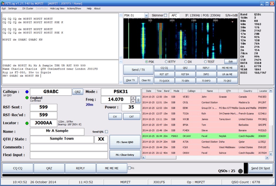 PZTLog is a freeware amateur radio logging application designed for Windows operating systems, facilitating rapid **QSO entry** and management. It integrates features such as DXCC statistics tracking, a built-in DX Cluster client, and support for various digital modes including PSK31, PSK63, PSK125, and RTTY. The software provides a straightforward interface for inputting essential contact details and supports real-time interaction with DX spotting networks, enhancing the operator's situational awareness during operating sessions. The application's utility extends to contest logging, offering a streamlined approach for competitive operating. PZTLog's capability to manage **DXCC awards** and integrate with digital mode operations positions it as a versatile tool for general logging and specific contest scenarios. Its design prioritizes ease of use for quick data entry, making it suitable for operators who require efficient logging without extensive configuration.
 -
 Conductor is a training tracking software that can organize any type of education, training, certification or license. It generates a multitude of reports perfect for regualtory bodies, free demo.
 -
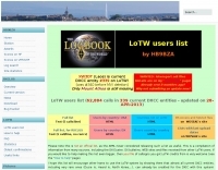 HB9BZA's LoTW users list, originally compiled since 2005 from DX-Cluster and user submissions, now primarily leverages the official ARRL full users list released on July 29th, 2017. This resource details 228,012 calls across 340 current DXCC entities, with the latest update noted on March 2, 2026. It offers various formats, including a full list, text versions, and breakdowns by country, providing valuable insights into LoTW participation for DXers. While the ARRL's official list with "last upload" dates diminished the original list's unique utility, HB9BZA's site continues to offer statistics and user counts by country, which remain of interest. The author, HB9BZA, expresses gratitude to contributors who helped maintain the list's accuracy over many years, achieving an impressive 96.4% match with the ARRL's data before the official release. Knowing which stations are LoTW active encourages more hams to join the system, demonstrating that even rare DXCC entities like Ducie Island or Heard Island can be confirmed quickly. For instance, HB9BZA recounts a 36-minute QSL confirmation for a 3A2MW contact. The list also integrates with the RXCLUS packet radio/telnet client, enhancing DXCC award tracking by identifying LoTW participants and utilizing upload dates for alarms.
 -
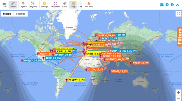 Monitoring real-time amateur radio activity is essential for DXers and contesters seeking rare contacts or tracking propagation. This online service aggregates DX spots from various **DX Cluster** networks, presenting them visually on a world map. Users can observe new spots as they appear, facilitating quick identification of active stations and potential openings. The platform offers filtering capabilities, allowing operators to narrow down displayed spots by specific bands such as 160m, 80m, 40m, 20m, 10m, and even VHF/UHF segments like 70cm and 23cm. Further refinement is possible by selecting the source continent of the spotter or the continent of the DX station, which assists in strategic operating. The service also includes a "Hot Now" list, highlighting currently active stations with recent spots. This dynamic display supports informed decision-making for pursuing **DX contacts** across different bands and geographical regions.
 -
 The _ISS Detector_ Android application, with over 5 million downloads, offers precise predictions for visible passes of the International Space Station. It notifies users minutes before an overhead pass, integrating local weather conditions to ensure optimal viewing opportunities. The core functionality focuses on the ISS, but in-app purchases extend its capabilities to track other celestial and artificial objects. Optional extensions, available via in-app purchase, allow users to monitor dozens of amateur radio and weather satellites, providing real-time transmitter information and Doppler frequencies. Additional extensions cover _Starlink_ satellites, the _Hubble Space Telescope_, rocket stages, bright satellites, comets, and planets, expanding the scope beyond the ISS to a broader range of observable space phenomena. The app's interface is designed for ease of use, displaying pass times, directions, and elevation. It adapts predictions based on the user's GPS location, ensuring accurate local forecasts. The latest update, dated April 3, 2026, includes corrections for magnitude values and various speed and stability optimizations.
 -
 Openaprs is a site dedicated to bringing you aprs tracking data and weather information.
 -
 Understanding the operational impact of Broadband over Power Line (BPL) on amateur radio communications is crucial for any radio amateur, especially given the potential for significant radio frequency interference (RFI). This ARRL tutorial delves into the technical aspects of BPL, explaining how the technology operates by transmitting data over existing electrical power lines, which can inadvertently radiate broadband noise across various amateur bands. My own field experience, particularly on the lower HF bands, has often involved tracking down noise sources that exhibit characteristics consistent with BPL emissions, making this a pertinent topic for maintaining clear receive conditions. The resource further details the specific FCC rules and regulations implemented to restrict BPL deployment. These regulations aim to protect licensed radio services, including amateur radio, from harmful interference. It outlines the technical standards and operational limitations imposed on BPL systems to minimize their impact on the electromagnetic spectrum, a critical aspect for contesters and DXers alike. For those engaged in RFI mitigation, the tutorial provides a foundational understanding of the regulatory framework that can be leveraged when addressing BPL-related interference issues. It serves as a valuable reference for hams seeking to comprehend the technical challenges and regulatory solutions surrounding this pervasive noise source.
 -
 Presents the VHFDX.EU web cluster, a specialized resource for VHF, UHF, and microwave DX spotting. It details the cluster's functionality, including real-time spot aggregation and a DXCluster Map interface for visualizing activity. The resource highlights its integration with the MMMonVHF backbone, ensuring a robust data flow for monitoring band openings and propagation events across higher frequencies. It also references reviews of the ON4KST and N0UK chat systems, which are frequently used in conjunction with VHF DX operations. The platform offers a mobile-optimized view for on-the-go access to DX spots, catering to portable and mobile operators. It further provides daily ES (Sporadic E) spot summaries, a critical feature for VHF operators tracking this specific propagation mode. The cluster serves as a central point for operators to share and receive information on rare grid squares, contest activity, and general band conditions above 50 MHz.
 -
 The ARRL Contest Results Database serves as a centralized repository for official scores and detailed breakdowns from numerous ARRL-sanctioned operating events. This resource typically features comprehensive listings of participants, their submitted logs, and final standings across different categories, modes, and bands. It allows hams to review their performance, compare results with other operators, and analyze contest trends over time, providing valuable insights into competitive amateur radio. Historically, the database has showcased the efforts of thousands of contesters, from single-operator entries to multi-operator, multi-transmitter stations. While the current status indicates scores are not immediately available, the database's primary function is to archive and present the outcomes of events like the ARRL DX Contest, Sweepstakes, and Field Day. This historical data is crucial for tracking individual progress, identifying top performers, and understanding the competitive landscape within the amateur radio community.
 -
 The Reverse Beacon Network (RBN) graph presents a dynamic visualization of amateur radio spots, specifically tracking CW, BPSK, and RTTY signals over the last 15 minutes. Users can filter these real-time spots by DX continent, spotter continent, and individual frequency bands, including **160m through 70cm**. The interface also offers a bandwidth reduction option, which is particularly useful for operators with limited internet connectivity. This resource provides a unique perspective on propagation conditions and station performance by aggregating data from various _Reverse Beacon Network_ nodes. It automatically refreshes every 10 seconds, ensuring that the displayed information is current and relevant for active DXers and contesters. The graph's Y-axis represents time, with each spot indicating activity within a one-minute interval. Beyond the primary RBN graph, the platform also features dedicated maps for both DXCluster and RBN data, including azimuthal projections. An additional FT8 graph is available, though noted as being under construction, indicating ongoing development to expand its utility for digital mode enthusiasts. The system was developed by HA8TKS, with the initial concept attributed to CT1BOH.
 -
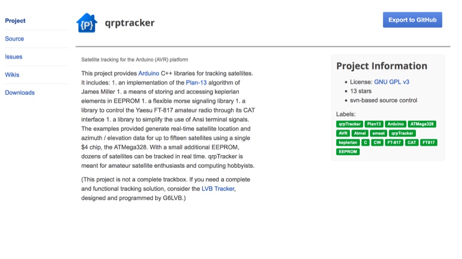 qrpTracker is a satellite tracking program that works on the popular and easy-to-program Arduino platform qrpTracker is meant for amateur satellite enthusiasts and computing hobbyists
 -
 Operating the AO-51 amateur radio satellite with a handheld transceiver (HT) presents a practical entry point for newcomers to satellite communications. This resource details the necessary steps and considerations for making basic contacts, focusing on accessible equipment. It covers fundamental concepts such as _Keplerian elements_ for satellite tracking and the importance of understanding Doppler shift effects on both uplink and downlink frequencies. The tutorial outlines a straightforward approach to satellite passes, emphasizing the use of readily available gear. It provides insights into antenna orientation and timing for successful two-way communication. The content aims to demystify satellite operation, enabling operators to achieve their first **AO-51** contacts with minimal specialized equipment. Key aspects include frequency management and basic operational techniques.
 -
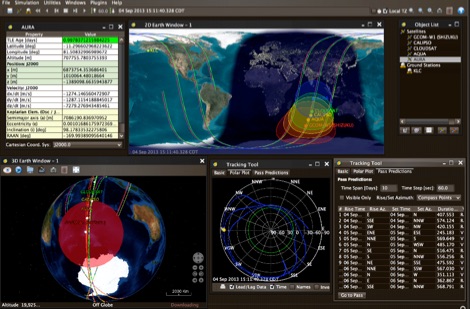 JSatTrak is a Satellite tracking program written in Java. It allows you to predict the position of any satellite in real time or in the past or future. It uses advanced SGP4/SDP4 algorithms developed by NASA/NORAD or customizable high precision solvers to propagate satellite orbits.
 -
 Nuke ham radio web site mainly in spanish with enbedded dx cluster and satellite tracking applets.
 -
 715 days, 6 hours, 58 minutes, and 29 seconds of uptime are reported for the YSFReflector-Dashboard by DG9VH, which monitors the IT C4FM SUD / ITALY-SUD reflector. This dashboard, compiled on December 1, 2017, provides real-time operational statistics for the reflector, including system information, disk usage, and connected YSFGateways. The dashboard also features a "Last Heard List" and an "All Heard List," displaying callsigns, durations, and timestamps (Europe/Rome) of stations active on the reflector. These lists offer a quick overview of recent activity, which can be useful for tracking **C4FM** traffic. While the resource is titled "IZ7AUH-6 DX Web Cluster," the primary content displayed is a **YSFReflector** dashboard. This suggests the platform might serve a dual purpose, offering both traditional DX cluster services and monitoring for Yaesu System Fusion reflectors.
 -
 The CES Wireless Technologies website details a range of **GPS fleet tracking** solutions designed for mobile information systems. It highlights offerings such as dispatch and mapping software, Automatic Vehicle Location (AVL) systems, and mobile data display terminals. The platform also mentions support for Automatic Number Identification (ANI) and Continuous Tone-Coded Squelch System (CTCSS) functionalities, indicating integration with two-way radio communication protocols. Specific products include GPS tracking devices and associated software for fleet management, emphasizing features like real-time location monitoring and operational efficiency. The site positions itself as a manufacturer in this specialized domain, catering to commercial and public safety sectors requiring robust mobile data solutions. While the page title mentions "Ham Radio Directory" categories, the content primarily focuses on commercial GPS and fleet management technologies, not amateur radio applications. The listed products are geared towards professional mobile radio (PMR) environments rather than typical ham radio operations.
 -
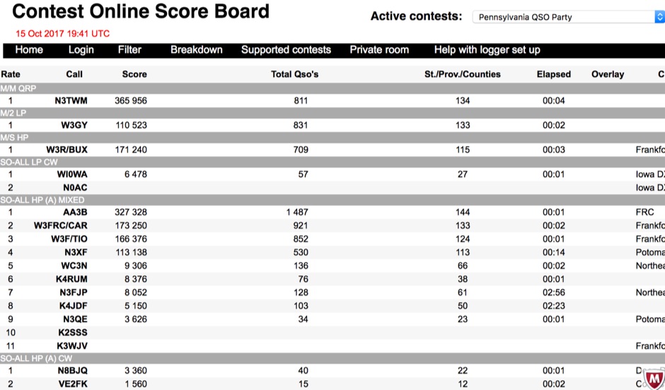 Aggregating real-time contest scores, this online scoreboard serves as a central hub for participants and spectators to monitor live progress during amateur radio competitions. It directly interfaces with widely used contest logging programs, collecting score data as operators make contacts. The platform then processes and displays these scores on dedicated contest pages, offering an immediate overview of standings. Supporting a diverse range of **DX contests**, the system accommodates various operating modes and rulesets. It facilitates score tracking for events like the YB DX RTTY, RSGB Commonwealth (BERU), EA PSK63, and the South America 10 Meter contest, among others. This functionality allows contesters to gauge their performance against competitors instantaneously, fostering dynamic participation. The scoreboard's integration with multiple contest log software applications ensures broad compatibility, making it accessible to a significant portion of the contesting community. It provides a crucial service by centralizing score visibility, enhancing the competitive experience for **amateur radio operators** worldwide.
 -
 A VHF UHF mobile operation setup with APRS tracking by wd6cmu
 -
 For over 50 years, Communications Specialists Inc. has been a cornerstone in specialized radio frequency solutions, initially gaining prominence with their **CTCSS** and **DTMF** tone signaling products widely used in amateur radio repeaters and commercial two-way radio systems. My own experience with their tone boards in various repeater builds confirms their reliability and ease of integration, a testament to their engineering. The company's legacy in tone encoding and decoding is well-established, providing robust solutions for access control and selective calling. Beyond tone signaling, Com-Spec has diversified into niche markets, including wildlife telemetry, pet tracking collars, and specialized tracking systems for model aircraft and rocketry. Their product line features compact transmitters and receivers designed for specific tracking applications, demonstrating a commitment to precision and durability in challenging environments. While some legacy products are no longer available, Com-Spec continues to innovate, as evidenced by the new R-30M receiver, which ships within five days. This focus on specialized RF applications, from tracking Alzheimer's patients to law enforcement, highlights their unique position in the radio communications industry.
 -
 OpenHamClock is a modern, open-source dashboard for amateur radio operators, designed as a web-based successor to the original HamClock. Deployable locally on a Raspberry Pi or via the cloud, it centralizes essential DX operations into a single, intuitive interface. At its core is an interactive world map that visualizes real-time DX spots, signal paths, satellite tracking, and POTA activators. The software seamlessly integrates critical tools like WSJT-X, DX Cluster, and PSKReporter for monitoring digital traffic. Additionally, it provides vital environmental data, including real-time space weather indices, solar activity, and personalized HF propagation predictions. With customizable themes and a modular architecture, OpenHamClock offers modern operators comprehensive, at-a-glance situational awareness of global radio conditions
 -
 N8VI\'s powerpoint on satellite keplerian elements.
 -
 Amateur radio direction finding, transmitter hunting. triangulating a radio signal direction and plotting its bearing on a map. hunters use doppler systems for tracking hidden transmitters
 -
 KComm, a logging and communication program, was specifically engineered for Elecraft K2, K3, and KX3 transceivers, leveraging the Lazarus cross-platform development tool. It operates natively on Windows XP and can be compiled for Linux, with potential for macOS, prioritizing low resource usage for casual DXers and contest participants. The software integrates with external applications like Fldigi for diverse digital modes and CW Skimmer for advanced Morse decoding, enhancing its functionality beyond basic logging. The design philosophy of KComm emphasizes utilizing the physical radio controls for operational adjustments, rather than replacing the transceiver's front panel. It facilitates keyboard CW operation via the Elecraft serial protocol and capitalizes on the K3 and KX3's built-in decoders for RTTY and PSK31. Additionally, KComm supports PSK31, PSK63, and PSK125 through the AE4JY PSK Core DLL on Windows and integrates with PSKReporter.info for spotting. While not a dedicated contest logging or award tracking program, KComm supports ADIF and Cabrillo export for casual use, allowing logs to be imported into other software. The author, G4ILO, ceased all software development, providing KComm "as is" without further support or updates; however, the source code is available under the GNU GPL for community continuation.
 -
 Tiny Trak is a simple choice for tracking, simply by using a usual VHF and TinyTrak as APRS modem.
 -
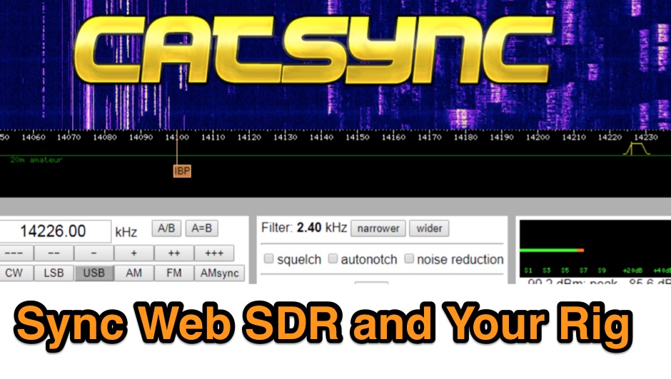 CATSync V1.30 integrates OpenWebRX support, expanding its capability to synchronize a local amateur radio transceiver's CAT control with a broader range of public WebSDR receivers. The software facilitates real-time frequency tracking, allowing the operator to adjust their physical rig's VFO and observe the connected WebSDR instantly follow the tuned frequency. This functionality is crucial for remote listening, signal comparison, and verifying propagation conditions across different geographic locations using a familiar hardware interface. The application supports both the classical WebSDR interface and KiwiSDR platforms, providing a consistent control experience across various online SDR deployments. It bridges the gap between local station operation and the vast network of globally distributed software-defined radios, offering a practical tool for DXers and contesters. CATSync is designed for Windows and Linux environments, with Android compatibility noted, making it accessible to a wide user base seeking to leverage WebSDR resources with their existing station setup.
 -
 This resource provides a discussion group platform for amateur radio operators interested in APRS within Argentina. It facilitates technical discussions, sharing of operational experiences, and coordination among users of the Automatic Packet Reporting System in the region. The group serves as a central point for exchanging information on local digipeater networks, IGate deployments, and mobile tracking applications, covering both hardware and software aspects relevant to APRS implementation. The forum enables members to post questions, offer solutions, and disseminate news related to APRS activities specific to Argentina, fostering a community-driven approach to problem-solving and knowledge transfer. It supports the collaborative development and maintenance of the APRS infrastructure, allowing for real-time interaction on topics such as frequency usage, network topology, and integration with other amateur radio services.
 -
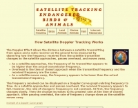 The Doppler Effect allows the distance between a satellite transmitting from space and a radio receiver on the ground to be measured by observing how the frequency received from the satellite transmitter changes as the satellite approaches, passes overhead, and moves away.
 -
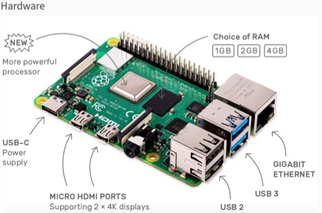 This resource is an online tutorial focused on setting up the Raspberry Pi for amateur radio applications. It covers the installation and configuration of various software packages tailored for digital communications and protocols, including _Packet Radio_ with Hamlib and Direwolf, as well as data modes like FLDigi and WSJT-X. The guide also details the integration of hardware components such as GPS clocks for time synchronization and real-time clocks for enhanced functionality. Users will find instructions for installing software like GPredict for satellite tracking and GQRX for software-defined radio (SDR) applications. The tutorial emphasizes practical steps, including the use of command-line inputs in the Raspberry Pi OS terminal, and provides troubleshooting tips for common issues such as faulty SD cards or insufficient power supplies. Operators are encouraged to explore various applications, including APRS iGates and WSPR beacons, to enhance their ham radio experience. The material is designed for licensed amateur radio operators with basic knowledge of electronics and computing.
 -
-
 Operating as a hub for its members, the Club Radioamateur Sorel-Tracy VE2CBS Inc. website provides essential information regarding club activities, membership management, and technical resources. It features articles on topics such as **D-STAR** digital voice mode training, offering a multi-capsule course for members to understand, configure, and effectively use D-STAR with ICOM equipment, including callsign routing and reflector connections. The site also details access to member cards, renewal processes, and upcoming events like the annual HAMFEST, which serves as a significant gathering for local radio amateurs. Beyond club-specific news, the site curates information on useful amateur radio tools and technologies, exemplified by articles on **HamClock** for propagation and satellite tracking, and a quick guide to Meshtastic for LoRa-based mesh networking. These resources aim to support members in exploring modern digital modes and enhancing their station operations, reflecting the club's commitment to fostering technical knowledge and community engagement within the Sorel-Tracy amateur radio scene.
 -
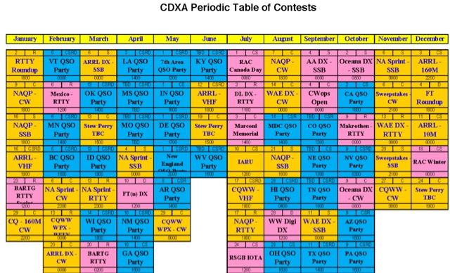 Presents the Carolina DX Association's (CDXA) _Contest Corner_, a dedicated resource for amateur radio contesting activities. It features a curated contest calendar, linking to external resources such as the _WA7BNM Contest Calendar_ and the _ARRL Contest Calendar_, providing a broad overview of upcoming events. The page also details CDXA's internal contest programs, including the "CDXA DX King" and "CDXA DX King Classic" for 2026, with specific links for members to submit their scores. Furthermore, the resource integrates with _3830Scores.com_, encouraging CDXA members to submit their contest results and select the club affiliation for tracking. It provides a direct link to view aggregated scores from participating CDXA members, fostering club competition and recognition. The "CDXA Periodic Table of Contest - 2026" is also mentioned, indicating a structured approach to contest planning for the year.
 -
 Approximately 524,475 Brazilian amateur radio operators are cataloged within this resource, offering a comprehensive database for the South American region. Each entry includes geographical coordinates, enabling users to visualize station locations directly within Google Earth. This functionality supports DXers in identifying potential contacts and understanding propagation paths relative to specific Brazilian QTHs. The platform serves as a digital callbook, primarily focused on the Brazilian amateur radio community. It facilitates the lookup of callsigns and associated location data, which is crucial for award tracking, contest planning, and general operational awareness. The integration with mapping services provides a visual dimension to traditional callsign databases, enhancing the utility for operators interested in geographical aspects of radio communication.
 -
 Accurate meteorological data is crucial for optimizing antenna performance, predicting propagation, and ensuring safe tower work. This resource provides a curated inventory of weather stations, including models like the _AcuRite Atlas_ with lightning detection and the _Ambient Weather WS-2902_ WiFi Smart Weather Station, which offer real-time data on environmental factors. The product listings detail specific features such as direct-to-Wi-Fi connectivity, rainfall tracking, and temperature insights, enabling informed decision-making for various amateur radio operations. The platform categorizes products by application, featuring weather stations tailored for home and backyard use, as well as more robust systems for farm and agriculture, which can be critical for field day operations or remote station monitoring. It also highlights _Made in USA_ options, emphasizing local manufacturing and support. Beyond weather instruments, the site also presents related surveillance technology, such as the _Waggle solar CCTV camera_, designed for outdoor reliability with an IP65 weatherproof rating. This integration allows for comprehensive monitoring of remote ham radio shacks or antenna sites, combining environmental data with visual oversight.
 -

-
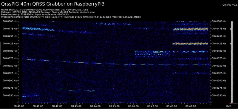 Monitoring extremely weak signals in the QRSS (Very Slow Morse) mode requires specialized receiving and processing capabilities to extract information below the typical noise floor. This project provides a software solution, _QrssPiG_, designed to run on a Raspberry Pi, enabling it to function as a dedicated QRSS grabber. It interfaces with various Software Defined Radio (SDR) devices, including the popular _rtl-sdr_ dongles and _HackRF_ units, to acquire raw I/Q data streams. The software then performs the necessary signal processing to visualize and decode these faint, long-duration CW transmissions, often operating with milliwatts of power. The system leverages the computational power of the Raspberry Pi for real-time signal analysis, allowing hams to participate in QRSS experiments and monitor distant beacons. It supports different SDR hardware, offering flexibility in setup and deployment for home stations or remote monitoring sites. The project includes detailed instructions for installation and configuration, making it accessible for those familiar with Linux environments. This grabber is particularly useful for tracking propagation on the LF and HF bands where QRSS activity is common, providing a visual representation of signal presence over extended periods.
 -
 How to setup a band-tracking panoramic signal display to work along to your transceiver.
 -
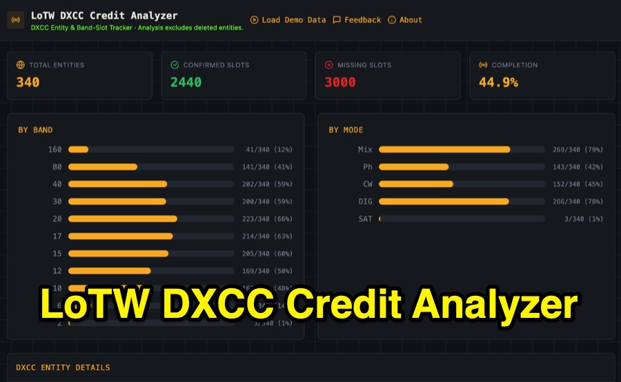 Visualizing DXCC award progress often requires manual parsing of Logbook of the World (LoTW) reports, which can be time-consuming and prone to error. This web-based utility streamlines the process by allowing hams to upload their LoTW DXCC Credit Report spreadsheet, providing an interactive dashboard for tracking confirmed entities, bands, and modes. It processes .xlsx, .xls, and .csv files, performing all calculations client-side within the browser for privacy and speed. The tool presents a comprehensive stats overview, detailing total entities, confirmed slots, and overall completion percentage. It includes progress bars for bands from _160m_ through _2m_, and modes such as CW, Phone, and DIG. A sortable DXCC Entity Details Table lists each entity, its confirmed count, and specific missing band/mode slots, with a CSV export option. Further features include a Band/Mode Matrix grid for granular confirmed status per entity, toggles for specific bands like _6m_ and _2m_, and tracking for DXCC Challenge progress across 10 eligible HF/VHF bands. It also highlights nearly complete entities and identifies most-wanted DXCC entities based on the uploaded data.
 -
 Demonstrates the practical application of APRS (Automatic Packet Reporting System) through the lens of HB9PVI's activities in Switzerland. It covers the system's core function of reporting geographical positions and telemetry data from various objects, including mobile stations, aircraft, and the ISS, distributed via packet radio and internet gateways. The resource highlights the routing paradigm shift introduced in April 2005, specifically the recommendation to use _WIDE1-1_ instead of RELAY and WIDE for digipeating to reduce duplicate packets. The page presents real-time maps displaying the positions of amateur radio stations in Switzerland and around Bern, updated every few minutes. It details specific callsigns like _HB9BA-2_ (HB9PVI's home QTH), _HB9BA-8_ (a weather station), and _HB9BA-4_ (a WIDE digipeater on Weissenstein mountain), providing context for their roles within the local APRS network. Links to track HB9PVI's mobile operations (_HB9PVI-9_) and handheld devices (_HB9PVI-15_, _HB9PVI-7_) are also provided. Furthermore, the resource curates a list of APRS software options for various operating systems, including _JavAPRS_ for Europe, _UI-view_, and _X-Astir_ for Linux, alongside digipeater/IGATE software like _DiXPRS_. It also offers downloadable APRS information, including a PDF article by HB9PVI and HE9ZGN, and a PowerPoint presentation in German, making it a repository of practical and historical APRS data.
 -
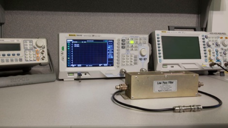 Testing a Bencher YA-1 low-pass TVI filter with a spectrum analyzer with tracking generator.
 -
 Small company based in Santa Maria, California, designing and manufacturing electronic products for amateur radio, education, and commercial users. Product line includes APRS devices for real-time vehicle tracking, weather monitoring, and remote telemetry, as well as the ADS-SR1 Simplex Repeater, the ADS-WS1 Weather Station, the SSTVCAM slow-scan TV camera, and GTRANS protocol translator for Garmin FMI.
 -
 Around 17% of the U.S. population experiences some degree of Dyslexia, a condition affecting language processing that can hinder amateur radio license candidates, often leading to repeated exam failures despite diligent study. This resource outlines methods for Volunteer Examiners (VEs) and Elmers to identify and assist candidates with cognitive disorders like Dyslexia and **ADHD**, which affects approximately 4% of U.S. adults. It emphasizes recognizing patterns in missed answers, such as spatial placement errors on answer sheets, and suggests reading questions aloud as an accommodation. The author, NC4FB, shares a structured approach developed over three years, involving extensive candidate interviews and a self-study program. This program utilizes specialized software with keyword highlighting and a unique font to improve comprehension for Dyslexic/ADHD candidates. It also incorporates **MP3 audio files** for subelement questions and correct answers, providing an alternative study method for those who benefit from auditory learning. Key elements of the support strategy include repetition, positive reinforcement, and timely progress updates, often visualized with a color-coded table tracking scores of 85 or higher. The goal is for candidates to pass three consecutive sample exams with at least 85% before attempting the actual license exam, demonstrating mastery of the material.
 -
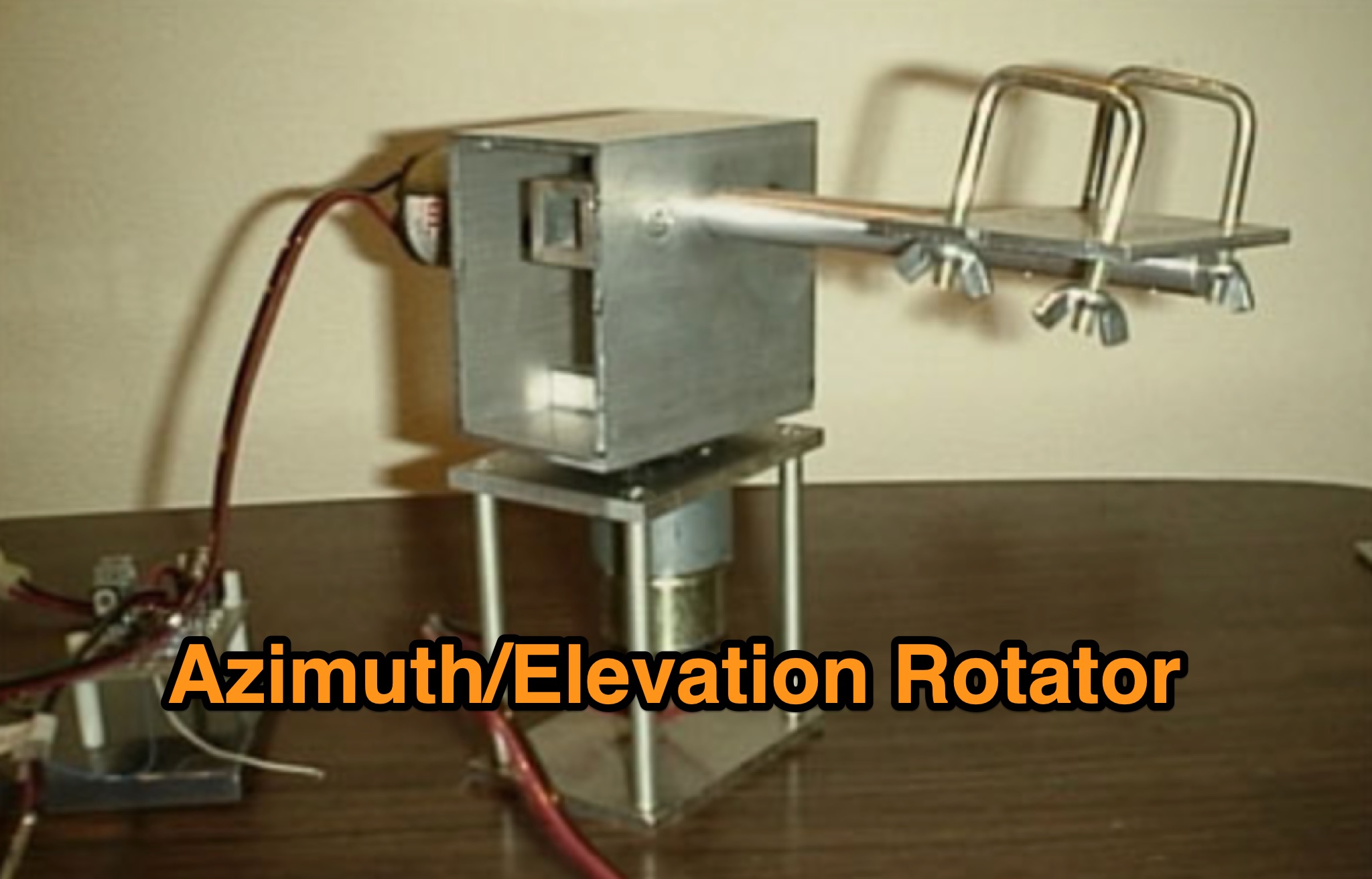 Learn how to build a simple 12vdc azimuth and elevation motor unit for the Arrow Satellite Antenna to improve your FM satellite communication experience. This DIY project involves using a camera tripod and basic materials like aluminum tube and standoffs. Get detailed instructions, including the gearhead motor product number for optimal performance. Discover where to purchase the necessary components and stay updated on alternative motor options. Enhance your ham radio operations with this homemade rotator setup, designed for easy satellite tracking and communication. Share feedback and connect with other radio enthusiasts for more tips and ideas.
 -
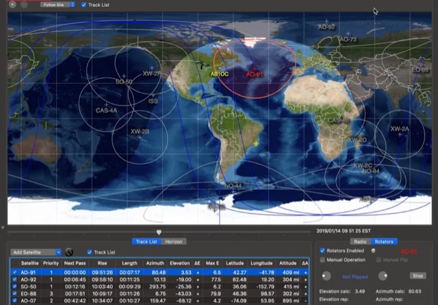 This article provides a step-by-step guide for assembling a Raspberry Pi-based Satellite Tracker Interface, designed to work with Green Heron Engineering's RT-21 controllers and MacDoppler software. The guide covers hardware assembly, SD card image installation, and system configuration for satellite tracking.
 -
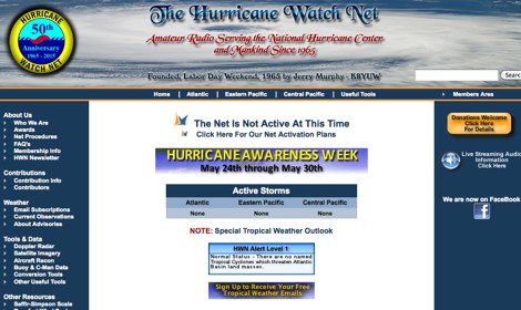 The Hurricane Watch Net (HWN) is an amateur radio organization dedicated to serving the National Hurricane Center and the public since 1965. It plays a crucial role in disseminating real-time tropical weather information for the Atlantic and Eastern Pacific regions. The HWN operates during hurricane events, providing updates and facilitating communication among amateur radio operators and emergency services. This network is essential for ensuring that communities are informed and prepared for severe weather conditions. In addition to its operational role, the HWN offers educational resources and outreach programs aimed at enhancing public awareness about hurricane preparedness. This includes providing access to tracking maps, storm surge information, and safety guidelines. The HWN encourages amateur radio operators to participate in its activities, fostering a spirit of community and collaboration in the face of natural disasters. By subscribing to their email updates, individuals can stay informed about active storms and receive vital safety information.
 -
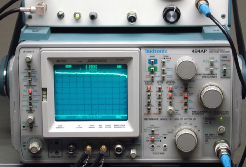 A spectrum analyzer is always an usefull amateur radio test equipment that should be present in a radio shack. Hams can use it for testing frequency response of filters, amplifiers, and other two-port RF devices. This article illustrate a tracking generator compatible with any spectrum analyzer in the Tektronix 490- and 2750-series lineups
 -
 The video delves into the significance of interference reduction in ham radio setups by utilizing ferrite materials. It demonstrates the use of spectrum analyzers and tracking generators to showcase the performance of ferrite devices in minimizing noise levels. The analysis includes insights on resistance levels, attenuation factors, and the impact of using multiple ferrite clamps or rings to enhance noise reduction capabilities. Viewers gain a deeper understanding of ferrite composition, characteristic curves, and winding techniques for effective noise attenuation in different frequency ranges. Overall, the video serves as a comprehensive guide to optimizing interference reduction in radio environments through the strategic use of ferrite materials.
 -
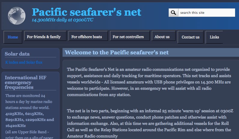 The Pacific Seafarer's Net is an amateur radio communications net organized to provide support, assistance and daily tracking for maritime operators.
 -
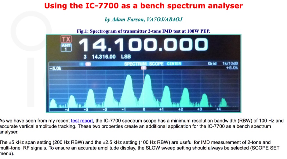 The Icom IC-7700 spectrum scope feature a minimum resolution bandwidth of just 100 Hz and provide also an accurate vertical amplitude tracking permitting to use the 7700 as a bench spectrum analyser.