Search results
Query: satellites
Links: 94 | Categories: 9
Categories
- Operating Modes > Satellites > Analog Satellites
- Operating Modes > Satellites > Digital Satellites
- Operating Modes > Satellites
- Software > Antenna rotor control
- Antennas > Lindenblad
- Operating Modes > Satellites > Real Time Tracking
- Antennas > Satellite
- Ham Radio > Blogs > Special Interest
- Operating Modes > WEFAX
-
 Online Yaesu FT-817 transceiver (receive only over the Net) using R.A.T.S. control software and MS Netmeeting for program access and audio. Asia's first online receiver, first online FT-817, and worlds first full-featured online receiver (operates just like a desktop radio including audio encoding time of less than 1 second). Operating from a flat in Kowloon, Hong Kong. Open to all.
 -
 Weather Fax for Windows hardware and Software.
 -
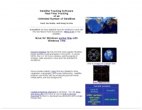 Real time tracking of an unlimited number of satellites, fast, accurate and easy to use. Automated FTP keps updates. Also support a great number of interface to control rotors azimuth and elevation plus frequency doppler shift. Since 2017 Nova is free to donwload and use. No support is given.
 -
 Select your favorite satellite and watch its trajectory on Google Maps in real time! Includes ISS tracking, Weather, Geostationary, GPS Military, and of course Amateur radio satellites. N2YO provides comprehensive real-time satellite tracking with particular emphasis on amateur radio satellites. The service offers precise pass predictions calculated for user-specific locations, displaying upcoming passes with azimuth, elevation, and duration data essential for ham operators planning satellite contacts. N2YO features dedicated tracking for amateur radio satellites including FM, linear transponder, and digital satellites, with frequency information and downlink/uplink details. The platform delivers live tracking visualizations on interactive maps, Doppler shift calculations, and automated email notifications for upcoming passes. This free resource integrates weather satellite tracking alongside NOAA imagery, making it invaluable for radio enthusiasts pursuing satellite communications.
 -
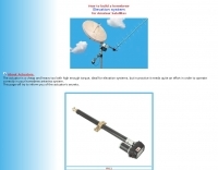 Smart homebrew antenna-ELEVATOR system with linear actuator. The actuator is a cheap and heavy tool with high enough torque, ideal for elevation systems, but in practice it needs quite an effort in order to operate correctly in your homebrew antenna system. This page inform you of the actuator's secrets.
 -
 Orbitron, a cardware application, provides robust satellite tracking capabilities for radio amateurs and visual observers alike. It leverages NORAD SGP4/SDP4 prediction models to accurately display satellite positions in real-time or simulation, accommodating up to 20,000 objects loaded from _TLE files_. The software includes an advanced search engine for satellite passes and _Iridium flares_, offering printable results for planning observations or QSO attempts. Sebastian Stoff's creation supports various visualization options, including a 'Nightlife' dark color scheme for nocturnal use, and integrates a database of cities and satellite frequencies. Users can synchronize their PC clock via NTP and update TLE data over HTTP, with ZIP support. The application also features rotor and radio control capabilities, either built-in or through user-defined drivers, which is particularly useful for automating antenna pointing during satellite passes. Its interface is designed for ease of use, making satellite tracking accessible even for beginners. First released in 2005, Orbitron 3.71 runs on Windows 9x/Me/2k/XP/2k3/Vista and can operate on Linux via _Wine emulation_, requiring minimal system resources. The software's precision relies on periodic TLE updates, especially for low-Earth orbit objects, to account for orbital decay and maneuvers by satellites like the ISS or Soyuz.
 -
 Satscape is a freeware program for the PC Macintosh and Linux. It produces real-time displays of where any Satellite is, and predicts passes for your locale. There are about 8000+ satellites in orbit, a lot of these are just junk and debris such as discarded rocket bodies, but quite a few are working Satellites.
 -
 Here is a high-performance hand-held beam antenna that is easy to build and guaranteed to improve your downlink from the LEO satellites over ANY rubber duck or mobile whip
 -
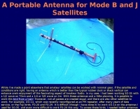 A portable antenna for mode B and J satellites
 -
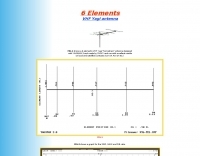 A 6 elements VHF Yagi antenna designed with YAGIMAX 3 and made by SV1XY with excellent results on local and satellites contacts like UO-14 and AO-27
 -
-
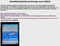 On the Satellitenprogram of DJ0SX Peter one can provide time schedules for over 500 satellites or count 23 satellites real-time imTextmode. The large advantage exists in thought out and of long observation practice which are due flexibility in the selection and the requirements to a satellite program. The program runs under Windows 95/98, NT, XP, 2000
 -
 A 2-meter Turnstile antenna, detailed for amateur satellite communication, offers a straightforward build for those looking to engage with orbiting transponders. The author, WB8ERJ, shares his personal design and construction methods, emphasizing the antenna's simplicity and effectiveness for LEO (Low Earth Orbit) satellite work. This design provides a circularly polarized signal, crucial for mitigating _Faraday rotation_ and signal fading often encountered with linearly polarized antennas when tracking satellites. Construction involves readily available materials like PVC pipe and copper wire, making it an accessible project for many hams. The article includes practical advice on element spacing and feed point considerations, drawing from the author's hands-on experience in the shack and field. It highlights the antenna's utility for receiving signals from various amateur satellites, including the popular AO-91 and AO-92. The Turnstile's inherent omnidirectional pattern in the horizontal plane, combined with its circular polarization, yields consistent signal reception, often resulting in **stronger decodes** and **more reliable contacts** compared to basic dipoles or verticals.
 -
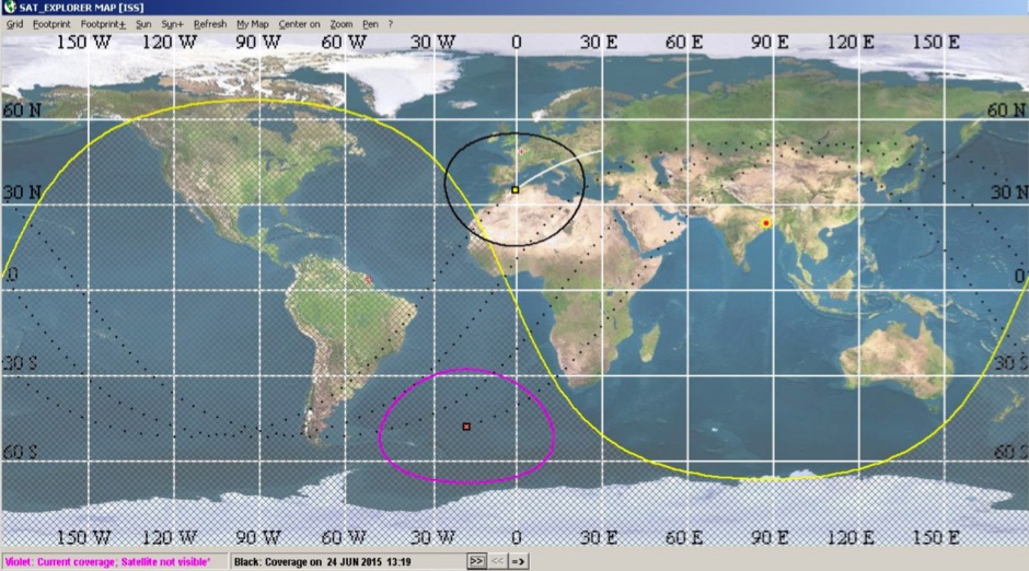 SAT_EXPLORER is a free software for satellite users. It provides very quickly and continuously visibility forcasts as a waiting delay ( satellite will be here IN ...)and a visibility duration (satellite will be visible FOR ...). Ten (and even more) satellites can be monitored simultaneously.
 -
 What type of antenna should I get? Well, the best type of antenna for working the OSCAR satellites are circular polarized antennas
 -
 Operating amateur radio satellites effectively requires precise knowledge of their orbital mechanics and pass times. Gpredict, a real-time satellite tracking and orbit prediction application, addresses this need by allowing operators to monitor numerous satellites simultaneously. It displays critical data such as position and pass details through various visualizations, including lists, tables, maps, and _polar plots_. Unlike many other satellite tracking programs, Gpredict introduces the concept of visualization modules. These modules enable users to group satellites and configure each group independently, offering unparalleled flexibility in how orbital data is presented. This modular approach supports tracking satellites from multiple observer locations concurrently, which is particularly useful for stations with diverse antenna setups or remote operations. Originally a GUI client for John Magliacane's _Predict_ program, Gpredict evolved to integrate its own tracking code for improved performance. The software is distributed under the GNU General Public License, ensuring it remains free and modifiable for the amateur radio community.
 -
 The DSP Satellite Transceiver is a conceptual transceiver designed as a dedicated unit for amateur satellite operators. The initial concept was brought about by the lack of satellite functionality on modern amateur radio transceivers, and the specialized requirements of the ham radio operator who utilizes OSCAR amateur satellites.
 -
 PocketPC freeware that track satellites, and display their position on a map of the world. It also has a display that shows other relevant information useful to Ham Radio operators to allow them to work them.
 -
 Ground tracks are the trace of the satellite's path over the ground. Amsat, ISS, geosynchronous satellites, navigation satellites, weather satellites, Iridium satellites, visible Satellites. Requires Java
 -
 The Arrow Antenna is a design classic: it combines light weight, compact design and functionality in a single package for operating FM dual band satellites such as AO-27, UO-14, SO-41 and SO-50
 -
 This software predicts future passes for amateur radio satellites for a specified location and period of time. It runs on the Android operating system
 -
 APTDecoder is a free software for recording and decoding signals transmitted by NOAA POES APT enabled weather satellites. It is run on a NT-based version of Window
 -
 Satellite Finder is a way to accurately point satellite dishes at communications satellites in geostationary orbit.
 -
 Allow 137 Mhz range by Steve Warley
 -
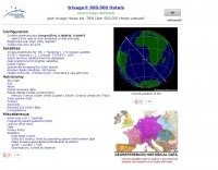
 The program calculates the actual position of the satellites using the NORAD 2LINE-element set, which is available via the Internet, for nearly all satellites. The position is then displayed in 3D-view as well as in 2D (mercator) view, where the footprints are also be shown.
 -
 Presented here is a high-performance, circularly polarized omni-directional antenna that is easy to build, easy to tune, inexpensive, and will work all the mode J Low Earth Orbit (LEO) satellites
 -
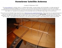
 Simple, inexpensive and lots of fun! Here is an easy to make home brew antenna that can get you on the air working satellites or be built for use as a portable hand held antenna to extend the range of your HT.
 -
 Automatic Picture Transmission (APT) is used by Satellites to enable a fully automated unattended reception of the transmitted pictures.
 -
 Live realtime satellite tracking system show current status of amateur radio satellites, ISS tracking is also provided by showing ISS Visible Passes based on your own location. This web site show the International space station live position and can be used as an iss tracker app to determine future satellite and ISS transit over your location.
 -
 If you are interested in the environment, the weather and other natural phenomena then there is something magical about being able to see pictures of the earth from space just as it is right this minute. One way you can do this is by receiving images from weather satellites.
 -
 Differential Global Positioning Service (DGPS) is a land-based augmentation system that receives and processes signals from orbiting GPS satellites, calculates corrections from known positions and broadcasts these corrections via a Medium Frequency (MF) Transmitter to DGPS users in the Broadcast Site's coverage area.
 -
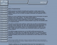 A comprehensive guide to receive Weather Satellites signals in wefax mode
 -
 This program has been designed for packet communication with ISS (International Space Station), PCSat or 'compatible' satellites with ease... Ideal for any UI packet communication.
 -
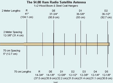
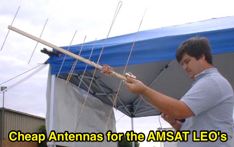 Cheap Antennas for the AMSAT LEO Kent Britain WA5VJB
 -
-
 allows a Macintosh computer to communicate via packet radio with the amateur packet satellites currently in operation using the 'PACSAT' protocols
 -
 The bass amateur radio IRLP group node 6391. victoria australia. info IRLP stands for the Internet Radio Linking Project. The aim of this project is to link radio systems separated by long distance without the use of expensive leased lines, satellites, or controllers.
 -
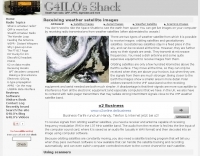
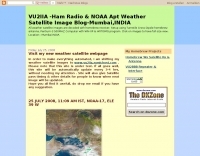 Decoding NOAA APT weather satellite images is achieved with a homebrew receiver and a Turnstile Cross Dipole antenna, feeding data to a Pentium-3 500MHz PC running Windows XP and the WXTOIMG program. This setup, operated by VU2IIA in Mumbai, India, focuses on capturing and processing signals from NOAA satellites to generate visual weather data. The blog documents the technical aspects of constructing the receiving station, including antenna design and receiver integration. It provides insights into the practical challenges and successes of amateur satellite reception, specifically for Automatic Picture Transmission (APT) signals. Operational details cover the software configuration and image processing workflow necessary to transform raw satellite data into usable weather imagery. The content serves as a practical guide for radio amateurs interested in satellite meteorology.
 -
 The 10-minute, 25-second video demonstrates making a QSO via the VO-52 amateur radio satellite, focusing on real-time Doppler shift correction. It features Simon, 2E0HTS, operating a Yaesu FT-847 transceiver and a homebrew dual-band Yagi antenna, specifically a 10-element 435 MHz Yagi for uplink and an IO Loop for 145 MHz downlink. The video visually details the operator's technique for continuously adjusting the uplink frequency to compensate for the satellite's changing velocity relative to the ground station, a critical aspect of successful satellite communication. The demonstration highlights the practical application of Doppler compensation, showing the operator tuning the transmit frequency to maintain a stable received signal from the satellite. This approach contrasts with systems employing automatic Doppler correction or full-duplex operation, providing insight into manual frequency management for satellite passes. The video serves as a direct, observational guide for hams interested in LEO satellite operations, particularly those using non-tracking, manually tuned setups.
 -
 Satellites and Oscar 40, Microwave and ATV
 -
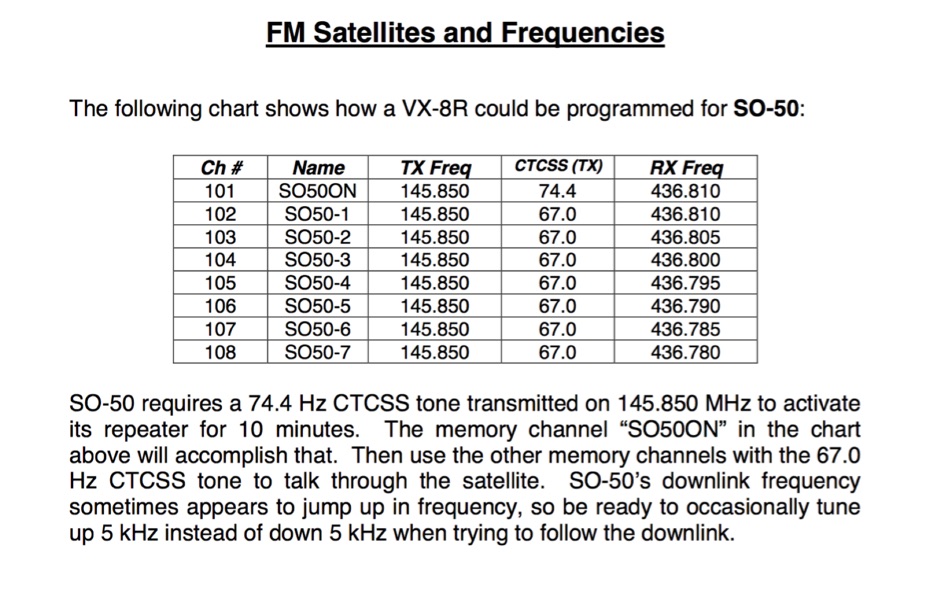 If you can program split-frequency memories in your dual-band radio, or your dual-band radio has two VFOs, you can work an FM satellite
 -
 Learn how to start using ham radio satellites for your DX contacts, PDF presentation by Dave Long
 -
 How to receive images from orbiting noaa weather satellites using simple receiving equipment and a computer by G4ILO
 -
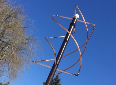 How to build a QFH (Quadrifilar Helix Antenna) to download images from weather satellites. A complete tutorial on assembling QFH antenna at home with simple and common tools
 -
 This resource provides a detailed historical record of satellite downlink frequencies, systematically organized by both frequency range and the satellite's launch year. It presents extensive listings covering segments from 8 MHz to 9000 MHz, including specific breakdowns like 136-137 MHz and 1600-2200 MHz. The data is segmented into distinct frequency blocks, offering granular information for various bands. The content delineates frequencies for satellites launched across several decades, with specific sections for years such as 2004, 1999, and extending back to 1967. This chronological organization allows for tracking the evolution of satellite communication frequencies over time. The resource serves as a reference for identifying operational downlink frequencies of historical space assets, which is particularly useful for satellite enthusiasts and those interested in _space tracking_ or _vintage satellite_ communications. The utility of this compilation lies in its specific historical data, providing a unique perspective on past satellite operations and frequency allocations.
 -
 NU-Tech is a powerful DSP platform to validate and real-time debug complex algorithms, simply relying on a common PC. Thanks to an easy plug-in architecture, the developer can write his own NUTSs (NU-Tech Satellites) in C++ and immediately plug them into the graphical interface design environment.
 -
 Ham satellites, 50 MHz, my hobbies, links.
 -
 Six meters (6m) operation and satellites and two meters band
 -
 The SPACEWARN bulletin is intended to serve as an international communication mechanism for the rapid distribution of information on satellites and space probes.
 -
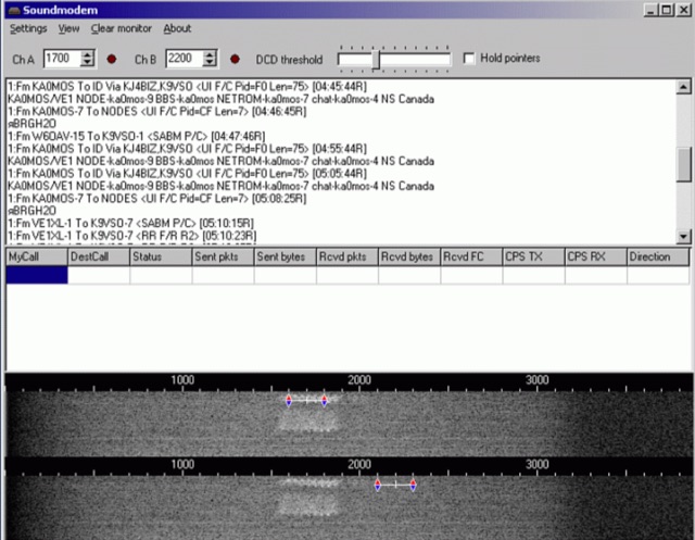 Soundmodem is a free software defined dual-port Packet-Radio TNC that implement a soundcard as a modem and supports AX.25 protocol. Soundmodem has been tested on Windows XP, Vista, 7, 8, 10 and has proved stable in operation. The Soundmodem may be used to build EMCOMM, APRS, BBS, Node station, for satellites