Search results
Query: data
Links: 698 | Categories: 27
Categories
- Technical Reference > Components > Component Database
- Software > Databases
- Technical Reference > Components > Datasheets
- Software > APRS
- Software > Beacon Monitoring
- Ham Radio > Regional > Brazil
- DX Resources > Callsigns
- Technical Reference > Coax Cables and Connectors
- Technical Reference > Components
- DX Resources > Contest > Contest Results
- Operating Modes > D-STAR
- Software > D-STAR
- Antennas > EH
- Operating Aids > Grid Squares
- DX Resources > Log Analysis
- Operating Aids > Log Formats
- DX Resources > Logs Search Services
- Propagation > MUF Indicators
- Operating Modes > NBEMS
- Propagation > Observatories
- Propagation > Propagation Forecast
- DX Resources > QSL manager
- Technical Reference > Repeater
- Operating Modes > Robust Packet
- Operating Modes > System Fusion
- Technical Reference > Vacuum tube
- Antennas > ZS6BKW
-
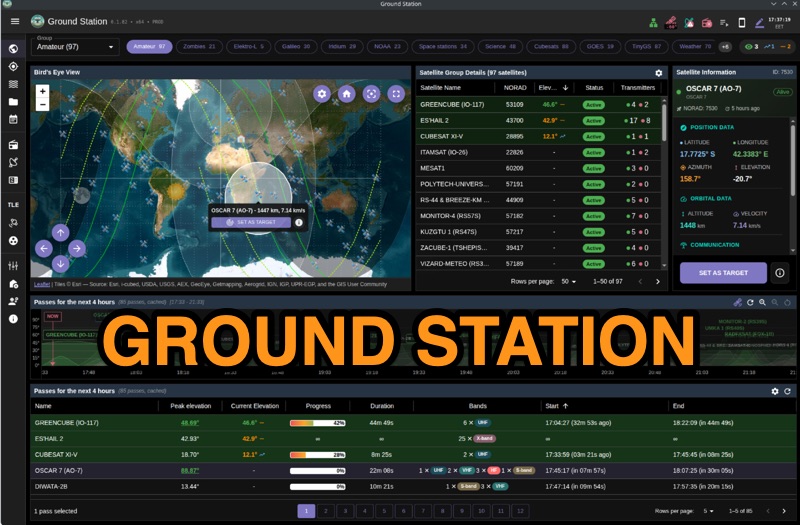 Ground Station offers real-time satellite tracking and radio communication capabilities, primarily for amateur radio operators engaged in satellite operations. It utilizes **TLE data** from sources like CelesTrak and SatNOGS for precise orbital prediction and integrates with various SDR devices, including RTL-SDR, SoapySDR, and UHD/USRP radios, to receive live signals. The software provides automated antenna rotator control and **Hamlib-compatible** rig control with Doppler correction, crucial for maintaining signal lock on fast-moving LEO satellites. It supports IQ recording in SigMF format and decodes several digital modes such as SSTV, FSK, GFSK, GMSK, and BPSK with AX25 USP Geoscan framing. Dedicated interfaces are available for satellite tracking, SDR waterfall displays with live transcription and packet decoding, and telemetry packet viewing. Users can manage TLE data synchronization and SDR hardware, along with browsing decoded outputs through an integrated file browser. An observations dashboard and DSP topology view further enhance the operational experience, providing comprehensive tools for monitoring and analyzing satellite passes.
 -
 SkyRoof is an open-source, 64-bit Windows application designed for amateur radio operators and satellite enthusiasts, combining satellite tracking and Software Defined Radio (SDR) functionality in a unified platform. The software provides real-time satellite tracking, pass predictions, and visual representations through Sky View, Earth View, and Timeline displays. It features an SDR-based waterfall display covering VHF/UHF satellite segments with Doppler-corrected frequency scales, automatic satellite labeling, and visual tuning capabilities. SkyRoof supports various SDR devices (Airspy Mini, SDRplay, RTL-SDR), external transceiver CAT control, and antenna rotator integration. The application automatically downloads satellite data from SatNOGS and other sources, offers voice announcements for satellite passes, and includes comprehensive frequency control with Doppler tracking, manual corrections, and RIT functionality for enhanced satellite communication operations.
 -
 System Fusion is Yaesu’s implementation of Digital Amateur Radio, utilizing C4FM 4-level FSK Technology to transmit digital voice and data over the Amateur radio bands
 -
 The Score Distributor facilitates real-time score forwarding for amateur radio contests, automatically transmitting data from various logging software to multiple online scoreboards. By configuring logging applications to send score data to the Distributor, operators ensure their current score is simultaneously represented on platforms like the _Contest Online ScoreBoard_ (COSB) and the Live Contest Score Server by R4WW. This system eliminates the need to choose a single scoreboard, providing broader visibility for participants. This utility enhances the competitive experience by allowing contesters to monitor their performance against other stations throughout an event. Observing real-time standings can provide significant motivation, particularly during periods of challenging propagation or when striving to maintain pace with club members or peers. The platform supports almost all major contest logging software, simplifying integration for a wide range of operators. Developed by WA7BNM, the Score Distributor was last revised on June 14, 2023. It aggregates score data, offering a unified point of submission that then disseminates the information, ensuring a **single point of entry** for broad scoreboard coverage and improving the dynamic feedback loop for participants.
 -
 TNXQSO.com offers a streamlined **log search** utility, specifically designed to consolidate QSL information for **DXpeditions** and special event stations. This online service aggregates data from prominent logging platforms such as Club Log, Logbook of The World (LoTW), and HRDLog, presenting a unified interface for radio amateurs to verify their contacts. The platform aims to simplify the process of confirming QSOs by providing direct links to the respective logging services, allowing users to quickly ascertain if their contact has been uploaded and confirmed. Users can input a callsign and band to retrieve immediate results, indicating whether a QSO is present in the linked logs. The service also supports DXpedition teams by offering tools for managing their own logs and QSL routes, without requiring an account for general log searching. This functionality proves particularly useful for DXers seeking rapid confirmation of rare contacts or for those managing their QSLing efforts across multiple platforms after a significant operating event.
 -
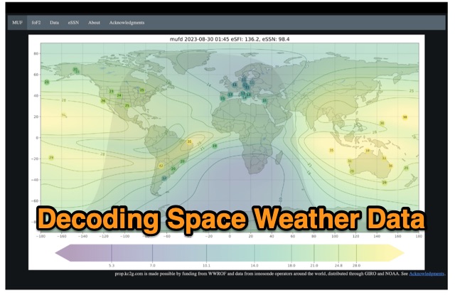 The article enlightens radio amateurs on utilizing real-time space weather data to optimize HF communication. Navigating through Hp30 index, MUF, f0F2, and eSFI metrics, it explains their significance in band selection and propagation forecasting. With essential links and practical insights, enthusiasts learn to discern optimal conditions for high-band DX, low-band DX, and NVIS operations. The author's observations and antenna optimization tips enrich understanding for effective HF operations.
 -
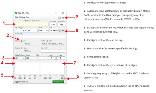 TNXLOG is a specialized logging application designed to complement the TNXQSO.com online service, focusing on real-time data exchange rather than serving as a standalone general-purpose logbook. The software facilitates the transmission of current **QSOs** to the TNXQSO.com server and simultaneously retrieves relevant geographical data such as RDA, Locator, and RAFA from the same server. It maintains real-time QSO statistics, providing operators with immediate feedback on their activity. Additionally, the application supports working with **CW macros** via a COM port, streamlining Morse code operations during contacts. This utility is specifically tailored for users of the TNXQSO.com service, enhancing their operational experience by automating data synchronization and providing instant access to location-specific information. Its design prioritizes integration with the online platform, making it a companion tool for those engaged in specific award programs or regional operating activities that benefit from real-time data exchange and statistics. The software's functionality is distinct from traditional logbook programs, emphasizing its role in a connected operating environment.
 -
 Optimizing a QRZ.com page involves adding essential callsign data, ensuring correct _Maidenhead Gridsquare_ and DXCC information in the Detail tab, and populating the Biography section with relevant station details. Operators should include their operating conditions, specific country references like WAB square, club affiliations, and detailed QSL information, specifying preferences for electronic confirmations (e.g., _LoTW_, Clublog) and paper QSLs (direct, bureau, SASE). The guide emphasizes the importance of accurate data for electronic logging software integration, which fetches Gridsquare, DXCC, and CQ/ITU zones to populate contact logs correctly. Further enhancements include leveraging the QRZ.com photo gallery for images and setting a primary image that logging software like _Log4OM_ can display. Advanced customization involves embedding external services via HTML source code. Examples include integrating HamAlert for DX Cluster spots, Clublog for log searches and Online QSL Requesting (OQRS), and Parks on the Air (POTA) statistics widgets from WD4DAN. Additionally, live weather information from Weather&Radar and solar data banners from HamQSL can be embedded, providing real-time environmental context for visitors to the QRZ page. These embedded tools require creating accounts on respective platforms and often involve copying specific source code snippets into the QRZ biography's HTML editor, ensuring callsign placeholders are updated.
 -
 A data converter for the Tandy WM918 weather station. The Weather APRS data converter project aims to create an interface to interpret data from the popular Tandy WM918 weather station and format it for transmission over packet radio. The South East Radio Group in South Australia has established a network of these weather stations to provide amateurs with regularly updated weather data. However, the WM918's data output is not structured for APRS weather reporting. This project describes a solution using a PIC microcontroller to convert the WM918 data into APRS-compatible strings that can be sent as beacons or connected packets. The interface offers features like position/positionless data, connected/beacon modes, and metric/imperial units. The goal is to create an interconnected weather reporting system for amateur radio operators
 -
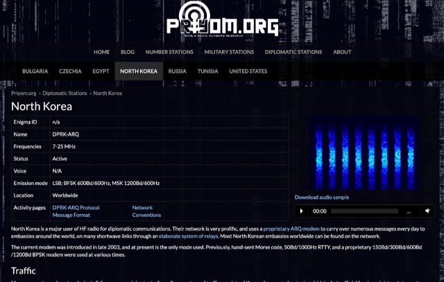 The resource details active HF radio networks maintained by foreign ministries for diplomatic communications, specifically listing operational schedules and frequencies. It currently covers networks for Bulgaria, Czechia, Egypt, North Korea, Russia, Tunisia, and the United States. The content provides specific operational parameters for these government-run shortwave stations. Information includes details on _legacy modes_ of operation and specific transmission times. The site also includes schedules for various _number stations_ which often utilize similar HF spectrum allocations. The data presented aids in identifying and monitoring these unique, non-amateur radio signals across the shortwave bands. Specific sections are dedicated to the networks of North Korea and the United States, offering granular data for each.
 -
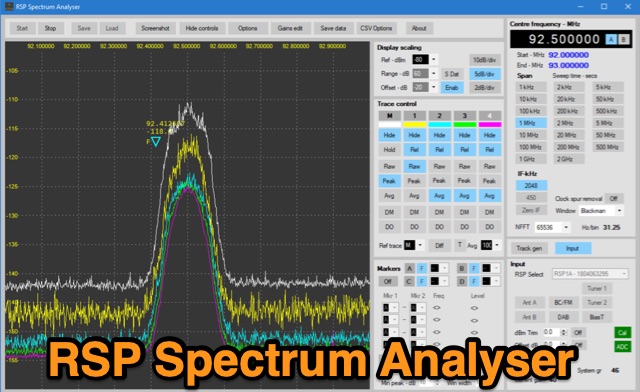 The analyser has been written to support the full range of SDRplay SDR radios including the new RSP1B. The analyser is capable of resolution bandwidths of less than 1Hz with sensitivity better than -145dBm. In addition to being able to run five separate traces, the analyser offers the ability to capture screen shots, export data in a range of formats and includes a versatile marker system. The analyser includes a comprehensive user manual and offers a very useful addition to any workbench.
 -
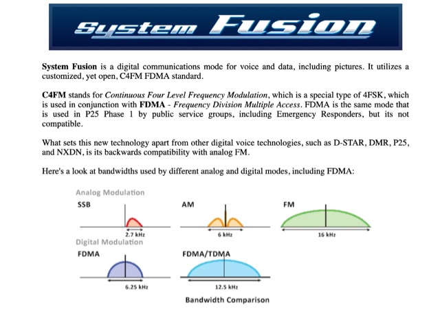 System Fusion is a digital communications mode for voice and data, including pictures. It utilizes a customized, yet open, C4FM FDMA standard. An introduction to Yaesu System Fusion by Wireless Society of Southern Maine
 -
 A real-time, responsive map view of APRS (Automatic Packet Reporting System) information, CWOP (Citizens Weather Observer Program), and other APRS-IS sources across the world. The N2RWE Real-time APRS Map leverages cutting-edge technologies and custom software to present a dynamic and user-friendly platform for visualizing Automatic Packet Reporting System (APRS) data. This web application aggregates real-time station locations from various public sources, offering a comprehensive view of APRS activity. It caters to both novice and experienced users by providing features like Maidenhead Grid maps, station lists, license plate searches, and advanced tools for geolocation, address lookup, and data analysis. Additionally, the platform integrates with Summits on the Air (SOTA) information, enhancing the experience for SOTA enthusiasts. By actively supporting the #APRSThursday net, the N2RWE Real-time APRS Map fosters a collaborative environment for the APRS community.
 -
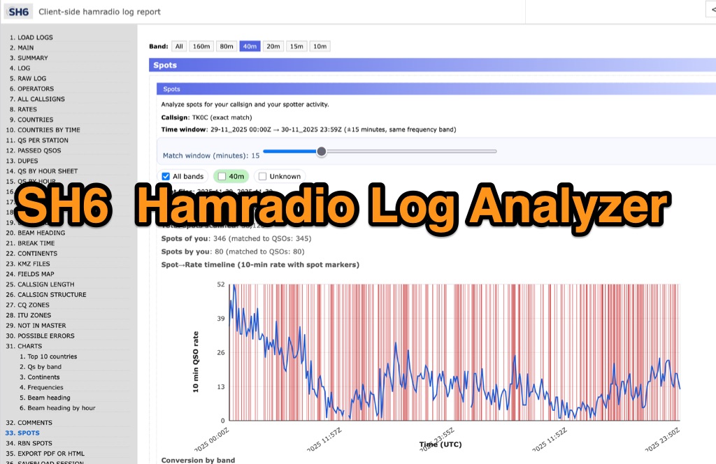 SH6 is a versatile, browser-based utility designed for the detailed analysis and visualization of amateur radio contest logs. Supporting standard formats such as Cabrillo and ADIF, the tool allows operators to upload personal files via drag-and-drop or access a searchable public archive containing over one million logs. Key capabilities include comprehensive performance metrics, offering summaries of band breakdowns, QSO rates, and beam headings. Furthermore, SH6 provides advanced geographic visualization through interactive maps, analyzing contacts by country, zone, and continent. A standout feature is the side-by-side comparison mode, enabling users to contrast two distinct logs for strategic assessment. SH6 transforms raw log data into actionable insights regarding operator performance without requiring software installation.
 -
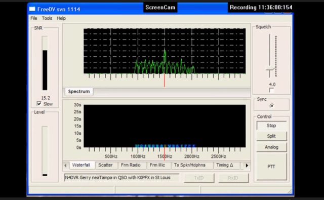 FreeDV uses an audio codec as a software based modem to decode and encode the voice and text data from your computer. The data is encoded and then is transmitted over the HF radio using AF signals that can then in turn be decoded by the receiving station.
 -
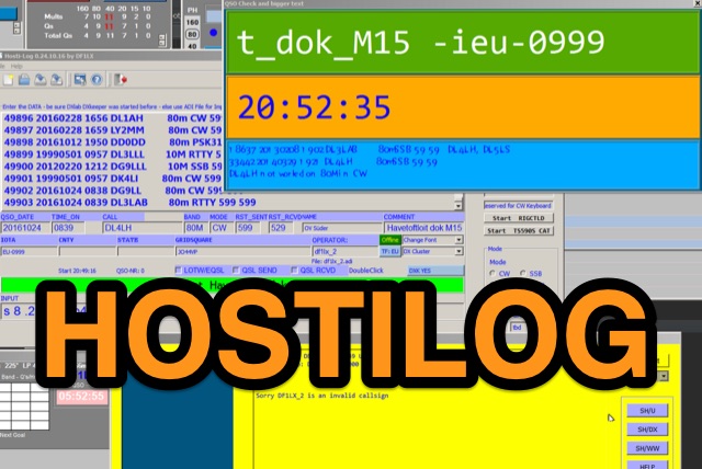 Hostilog, developed by DF1LX using Python 3.5 and PyQT5, is a logging application designed for high-speed QSO data entry, achieving rates of 300–400 QSOs per hour from handwritten logbooks. The software prioritizes keyboard input, minimizing mouse usage for efficiency. It incorporates a cluster window with RegEx filtering capabilities and facilitates UDP transfer of QSO data to _DXkeeper_ from the _DXLab Suite_. The program supports basic rig control via _Hamlib_, with configuration examples provided for radios like the TS-590S using `rigctld`. Hostilog can process 50,000-line ADIF files in under 10 seconds and includes features for combining and sorting ADIF data. While primarily a Windows application, it runs under _WINE_ on Linux, with specific notes on Ubuntu compatibility. Recent updates, including a version from August 28, 2024, address bugs and improve UI, with documentation available in both German and English.
 -
 Spotty leverages Philip Gladstone’s pskreporter.info data, delivered via an MQTT broker by Tom Fanning (M0LTE), to offer a responsive web application for visualizing propagation. The Map View presents a default visualization (grid AA00 / callsign MY8CALL) and distinguishes signal types: small spots for signals heard by a location, large spots for transmissions from a location, and teardrop markers for transmissions from the monitored callsign. Clicking a spot reveals detailed signal data in an overlay. The application includes a Log View for raw spot data and a Settings tab for customization. Users can filter tracking by specific Callsign or Grid, with preferences saved to the browser. A notable feature is the Time to Live (TTL) setting, adjustable from the default 60 seconds, which controls spot visibility duration to manage map clutter during high-traffic periods. The tool provides a clear, logic-driven interface for real-time signal monitoring.
 -
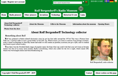 Bergendorffs Radiomuseum Radio Collection, images and technical data on various devices that are in the collections.
 -
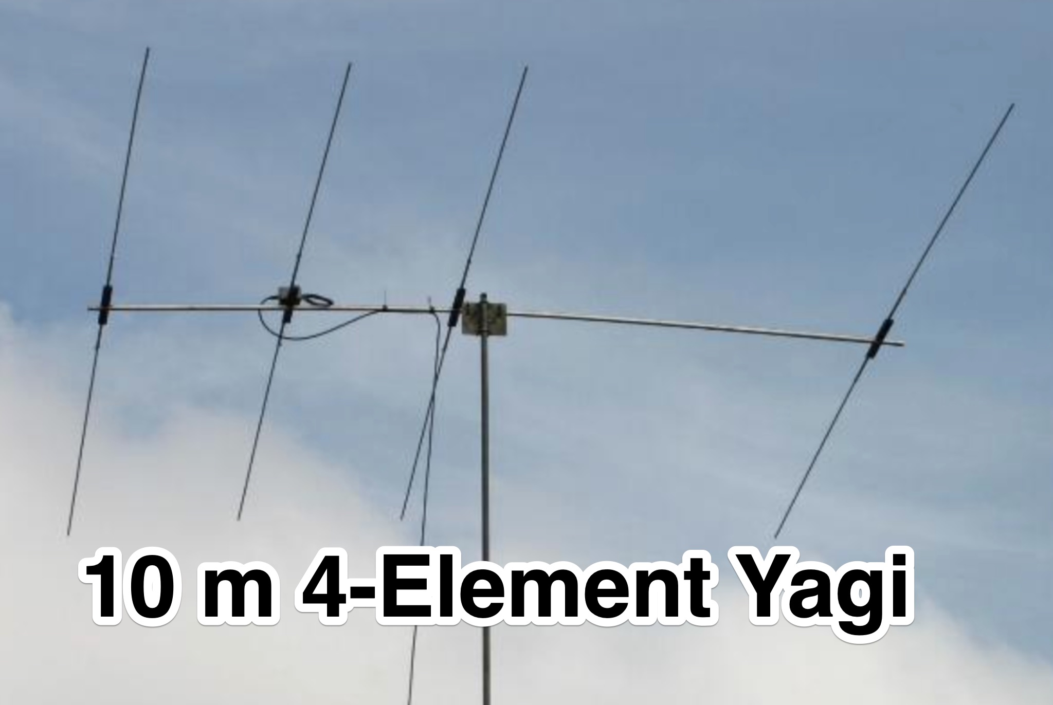 This page provides construction details for a 4-element 10-meter Yagi antenna with 28 Ohm impedance. It includes information on the elements, positions, diagrams, and data related to frequency, gain, front-to-rear ratio, radiation resistance, SWR, and loss. The content is aimed at hams or radio operators interested in building and optimizing Yagi antennas for the 10-meter band.
 -
 This page provides updated data and statistics about United States amateur radio operators, including historical totals, demographics, and geographic distributions. It also explains the Amateur Radio Service, highlighting its role in promoting wireless communication and technological advancements. The page is a valuable resource for hams interested in understanding the current landscape of amateur radio in the United States.
 -
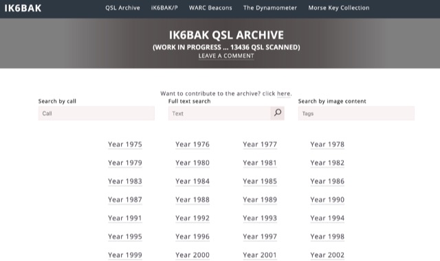 Online QSL archive counting 13400 QSL scanned and indexed online with a searchable database
 -
 This amateur radio website explains how to use the free AGWPE utility program to send and receive packet data using the sound card of your PC. Note that AGWPE is a Windows-only program. This website, which is hosted on SV2AGW's web site, focuses on support for the sound card packet features of AGWPE.
 -
 DecoAlert 1.0 Beta is a companion application designed to enhance the digital mode operating experience, specifically for FT8, FT4, and FT2. It operates by monitoring UDP data streams from primary decoding software like _Decodium_ and _WSJT-X_ on port 2237. The software provides real-time, priority-based audio alerts using WAV sounds for various conditions, including All Time New Ones (ATNO), new DXCC entities per band/mode, user-defined watchlist callsigns, new Maidenhead grid squares, and LoTW-active stations. It also highlights previously worked stations (B4) and integrates live DX spots from Telnet clusters, offering a comprehensive suite of tools for serious digital mode operators. The application features a built-in SQLite database for tracking worked stations and integrates with LoTW user lists to identify confirmed contacts. A DX Cluster client supports multiple Telnet servers, providing a broad view of propagation. PSKReporter statistics are available by band and mode, offering insights into signal paths. The QSO log viewer includes search and filter capabilities, while an _OpenStreetMap_ (OSM) interface visualizes spot locations, aiding in situational awareness. DecoAlert requires Windows 10/11 (64-bit) and compatible digital mode software configured to send UDP data.
 -
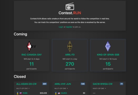 Presents a dynamic platform for real-time amateur radio contest scoring, enabling participants and enthusiasts to monitor ongoing competition results. The system processes submitted contest data, displaying live scores and competitor standings as they update. Users can observe the progress of various contests, gaining immediate insight into the competitive landscape. This resource serves as a central hub for following _DX contests_ and other operating events, offering a transparent view of current standings. It facilitates an engaging experience by providing up-to-the-minute score updates, reflecting the intensity of _on-line contesting_ and the efforts of operators globally. The platform's utility extends to both active participants submitting scores and observers interested in the competitive dynamics. It aggregates data from multiple sources, presenting a consolidated view of contest activity. The system's design emphasizes rapid data processing and clear presentation of results, crucial for high-stakes events like the _CQ World Wide DX Contest_.
 -
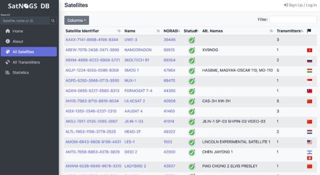 SatNOGS DB is an effort to create an hollistic, unified, global database for all artificial objects in space (satellites and spacecrafts). You can view and export the data, contribute to it, or even connect your application using API.
 -
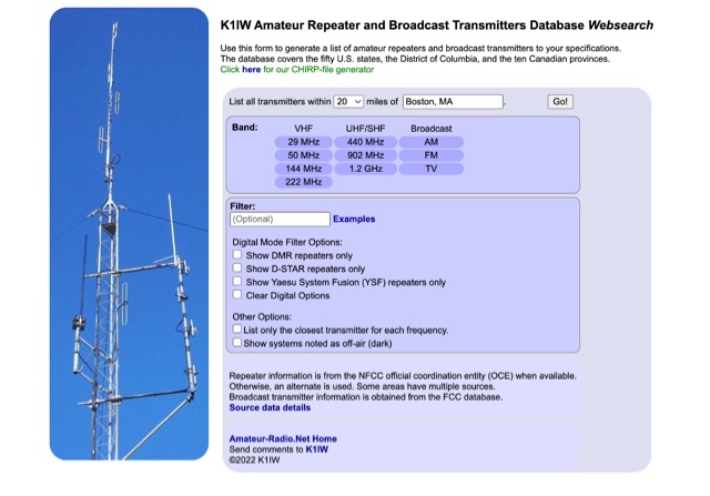 Use this form to generate a list of amateur repeaters and broadcast transmitters to your specifications. The database covers the fifty U.S. states, the District of Columbia, and the ten Canadian provinces.
 -
 Wavelog, a web-based amateur radio logbook application, launched in February 2024, represents a significant fork from the established Cloudlog platform, developed by a core team including DF2ET and DJ7NT. This open-source project focuses on delivering advancements in both stability and functionality, specifically tailored for the amateur radio community. The application allows users to manage their radio logs from diverse environments, including professional servers, standard web hosting, or even compact _Raspberry Pi_ setups. The platform distinguishes itself through its emphasis on simplicity, robust features, and versatile accessibility, enabling operators to log contacts from virtually any location. It supports various operating modes and data formats, providing a flexible solution for tracking QSOs and managing station activities. The project's development is driven by the collaborative spirit of the amateur radio community, prioritizing utility and user experience over commercial objectives. Key features include comprehensive logging capabilities, support for multiple bands and modes, and integration with common amateur radio data standards, ensuring broad utility for DXers and contesters.
 -
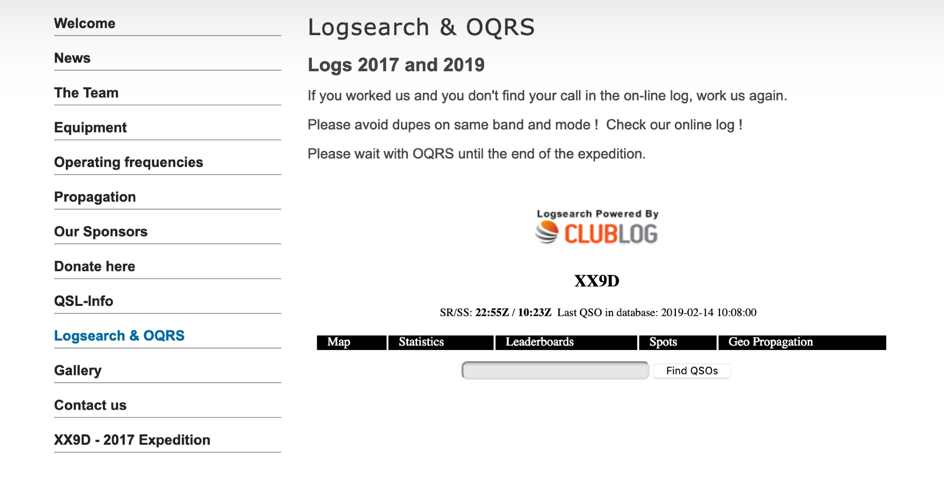 The XX9D Log Online provides a direct log search function for the DXpedition to Macao, specifically detailing operations conducted in 2017 and 2019. This service allows amateur radio operators to verify their contacts (QSOs) with XX9D, a critical step for QSL card management and award applications. Users are explicitly advised to consult the online log to prevent duplicate contacts on the same band and mode, optimizing efficiency during active DXpedition periods. This online tool supports the "DX Code Of Conduct," promoting ethical operating practices within the amateur radio community. The platform facilitates the Online QSL Request System (OQRS), streamlining the process for requesting QSL cards without the need for traditional bureau or direct mail methods. Operators are instructed to defer OQRS submissions until the conclusion of the DXpedition, ensuring all logs are finalized. The log search interface is powered by CMSimple, a content management system, indicating a straightforward, database-free web application. The resource is designed for ease of access, providing a clear method for DXers to confirm their contacts and manage QSL requests efficiently.
 -
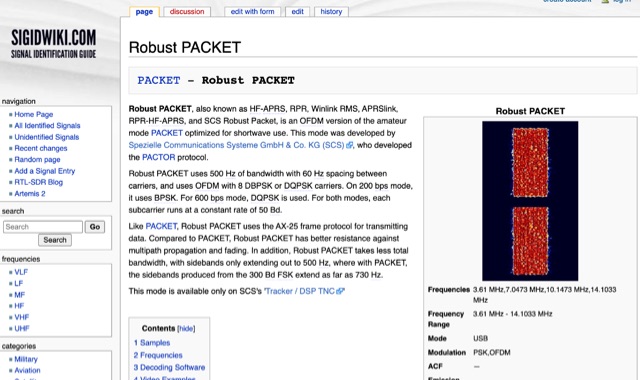 Robust PACKET, developed by Spezielle Communications Systeme GmbH & Co. KG (SCS), is an OFDM variant of the amateur PACKET mode specifically engineered for HF operation. This mode utilizes a 500 Hz bandwidth with 60 Hz carrier spacing, employing OFDM with 8 DBPSK or DQPSK carriers. It supports 200 bps using BPSK and 600 bps with DQPSK, with each subcarrier operating at a constant rate of 50 Bd. Robust PACKET leverages the AX-25 frame protocol for data transmission, similar to standard PACKET. Compared to traditional PACKET, Robust PACKET demonstrates enhanced resilience against multipath propagation and fading effects, critical for reliable HF communications. It also exhibits a more efficient spectral footprint, with sidebands extending only to 500 Hz, whereas 300 Bd FSK PACKET can produce sidebands up to 730 Hz. Operational frequencies for Robust PACKET include 3.61 MHz, 7.0473 MHz, 10.1473 MHz, and 14.1033 MHz, with specific regional frequencies also documented. Decoding software options for Robust PACKET include Wavecom W-Code and Wavecom W-Spectra. The mode is primarily supported by SCS's 'Tracker / DSP TNC' hardware.
 -
 Automatically input GPS location data from an Android device to the transceiver, Compatible with IC-7100, IC-9100, IC-9700, ID-4100A/E, and ID-5100A/E.
 -
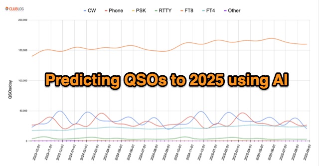 In an innovative analysis, Michael G7VJR employs NeuralProphet to predict ham radio modes' usage trends. The AI model, leveraging deep learning, forecasts a steady FT8 dominance, with slight declines in CW and Phone activities. This approach simplifies statistical predictions, showcasing the power of AI in understanding complex patterns and facilitating insightful time series projections. Access the freely available Club Log data for continuous exploration.
 -
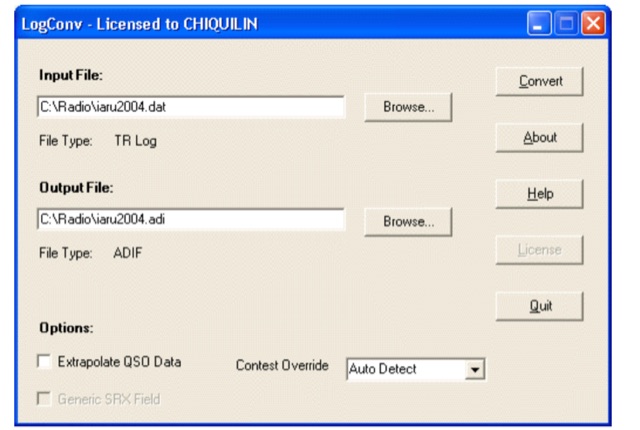 LogConv is a versatile utility designed to convert Amateur Radio log files between various formats such as ADIF, Cabrillo, CT9, CT10, EQF, and TR Log. It offers both GUI and Command line versions for user convenience. LogConv normalizes QSO data, breaking it into separate fields for better visibility. Additionally, it can extrapolate geographic information from contest exchanges, aiding in awards tracking
 -
 QRP is a way of operating that involves using low power transmitters, that are no more than 5 Watts for Morse or data modes, or 10 Watts pep for voice. Introduction to QRP operations
 -
 The Weather Fax plugin for OpenCPN allows you to directly open image files or decode audio faxes into images. With easy calibration, these images can be overlaid on charts. It supports image conversion in Mercator, polar, conic, and uniform coordinates and can transform any image into a raster chart. Additionally, it includes a built-in database for HF radio fax stations via SSB and another for retrieving data from meteorological websites.
 -
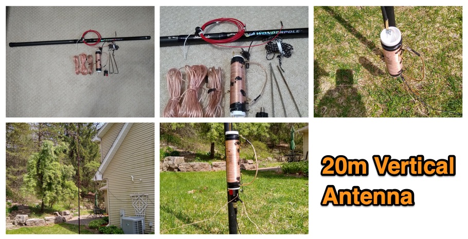 The 1/4 wavelength vertical antenna project, initially designed for 20 meters, has evolved into a versatile portable solution covering 10 through 60 meters. K0BXB details its construction, emphasizing a bottom-loaded design with a tapped loading coil and four 10-foot counterpoise wires. The author shares personal experiences and field results, including **18 QSOs** during a park activation on 17m and 30m with 10 watts, and a **2,435-mile** contact with a contest station in Bonaire on 20m using 5 watts. Comparisons are drawn to commercial offerings like the _Wolf River Coils TIA_ and _QRPGuys Triband Vertical_, highlighting the DIY antenna's small footprint, light weight, and ease of tuning for POTA activations. The resource includes insights into using test equipment such as the _NanoVNA_ for SWR optimization and discusses various radiator lengths, from 17-foot wire to a 102-inch whip, demonstrating adaptability for different portable setups. Construction tips cover coil winding, tap placement, and connecting feedlines and radials using common components.
 -
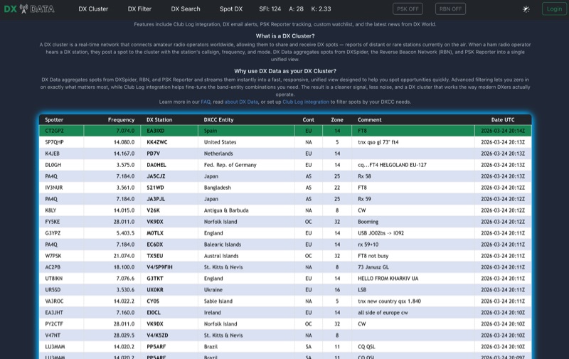 DX Data provides a unified view of real-time DX spots, aggregating data from **DXSpider**, the **Reverse Beacon Network (RBN)**, and PSK Reporter. This online service offers advanced filtering capabilities, allowing amateur radio operators to refine spot displays by DXCC entity, band, mode, CQ zone, and continent. It addresses the challenge of sifting through numerous DX spots by presenting a consolidated stream, enabling DXers to efficiently identify active stations across various bands and modes. The platform integrates with Club Log, which assists in fine-tuning band-entity combinations based on a user's logging history, thereby reducing irrelevant spot noise. Key features include DX email alerts, PSK Reporter tracking, and a custom watchlist for monitoring specific stations or regions. The service also incorporates a live news feed from DX World, providing current information relevant to the DXing community. This design aims to streamline the DX spotting process, offering a responsive interface for identifying operating opportunities.
 -
 This presentation offers a beginner's guide to digital communication modes in Ham Radio, specifically PSK31 and RTTY. It covers the basics like what data modes are and the equipment needed (radio, computer, interface). It explains the technical details like PSK vs. RTTY, AFSK vs. FSK, and data transmission processes. The presentation also provides instructions on software setup, live testing procedures, and where to find data transmissions on different bands. Finally, it covers communication styles and etiquette for data QSOs.
 -
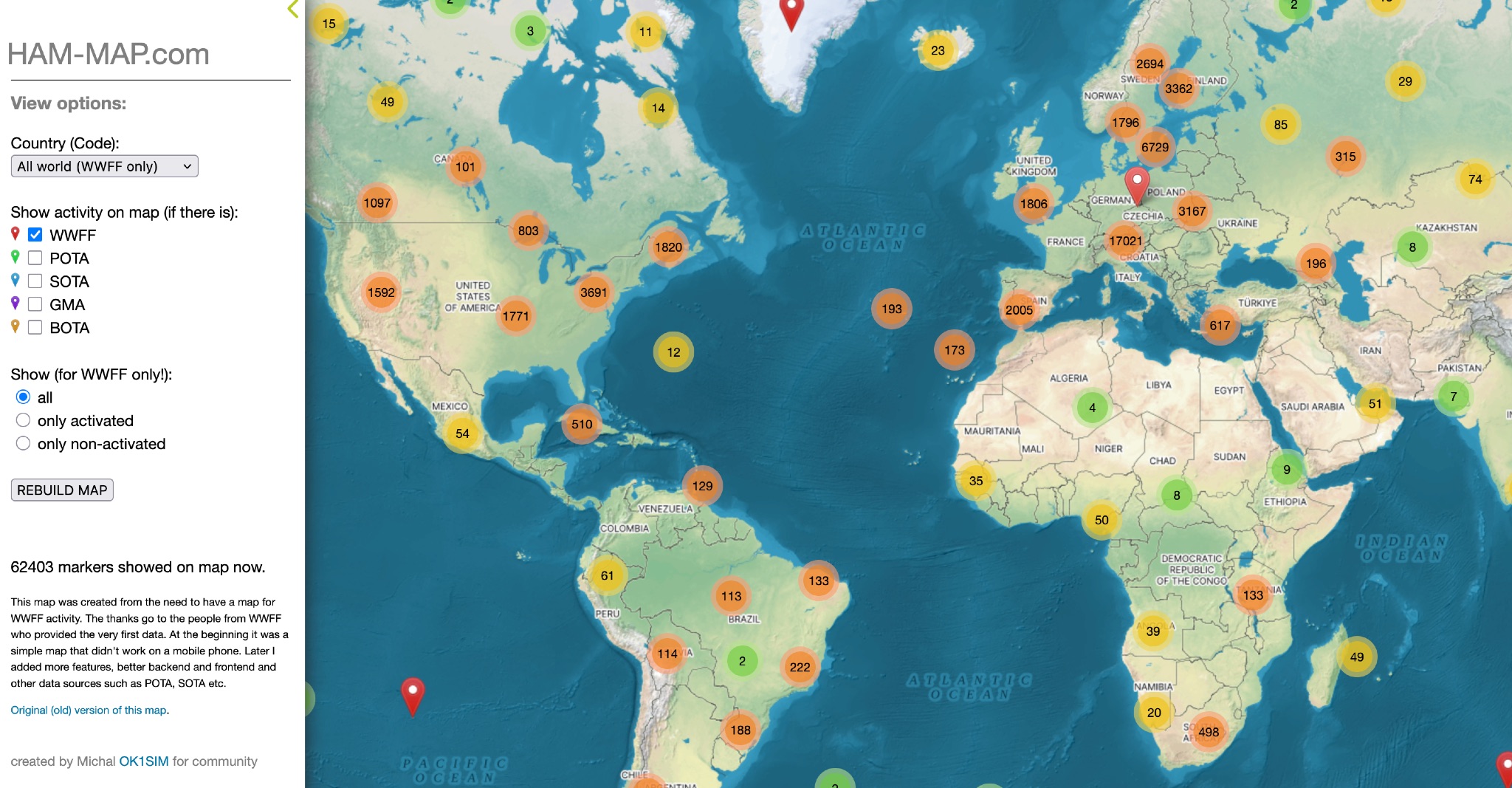 This map was created from the need to have a map for WWFF activity. The thanks go to the people from WWFF who provided the very first data. At the beginning it was a simple map that didn't work on a mobile phone. Later I added more features, better backend and frontend and other data sources such as POTA, SOTA etc.
 -
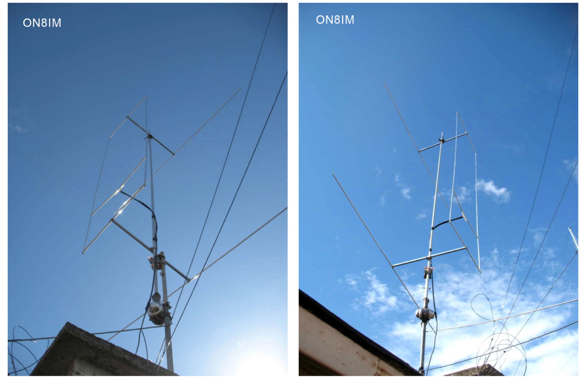 Explores the addition of a reflector to the traditional Hentenna design for 6m band, providing construction insights, performance comparisons, and modeling data
 -
 Approximately 100 MeshCom nodes are visualized in real-time on a geographical map, providing a dynamic overview of the LoRa mesh network. This resource, hosted by _OE1KFR_, details node positions, telemetry data, and message traffic. Users can measure distances between two selected nodes, view text messages with callsign, destination, and gateway information, and access position data including latitude, longitude, and altitude. The platform supports filtering by regions such as Europe, USA, and Asia, allowing operators to focus on specific geographical areas. The detailed node list table presents comprehensive status information for each node, including gateway callsign, firmware version, hardware type, and environmental telemetry like temperature, pressure, humidity, and CO2 levels. This granular data enables operators to monitor network health and individual node performance, facilitating troubleshooting and optimization of MeshCom deployments. The map interface enhances situational awareness for those engaged in LoRa mesh networking.
 -
 Compare the efficiency of two HF (or VHF) antennas by simultaneously transmitting FT8 on nearly the same frequency and analyzing PSKReporter SNR data. Determine the effectiveness of your new antenna compared to the old one in dB, to several decimal places. Run FT8 on two transmitters with different call signs and equal power, connected to each antenna. AntennaCompare analyzes global signal reports, isolating antenna performance.
 -
 Operating on the HF and VHF bands, the URE WebCluster serves as a real-time DX spotting network for amateur radio operators. It aggregates DX spots from various sources, presenting them with detailed information such as DX callsign, frequency, mode, and spotter details. The platform integrates essential propagation data, including current solar indices like _K-index_ and _A-index_, alongside visual propagation maps, which are crucial for planning long-distance contacts. Users can submit new DX spots, contributing to the collective intelligence of the amateur radio community, and filter existing spots by band, mode, or callsign, enhancing operational efficiency. This resource enables operators to monitor band openings and identify active DX stations, significantly aiding in _DXCC_ pursuit and contest operations. The integration of solar-terrestrial data directly within the cluster interface allows for immediate correlation between propagation conditions and observed DX activity, a feature not universally present in all web clusters. By providing both raw spot data and contextual propagation information, the URE WebCluster offers a practical tool for real-time decision-making during operating sessions, allowing hams to quickly adapt to changing band conditions and target specific _DX_ entities.
 -
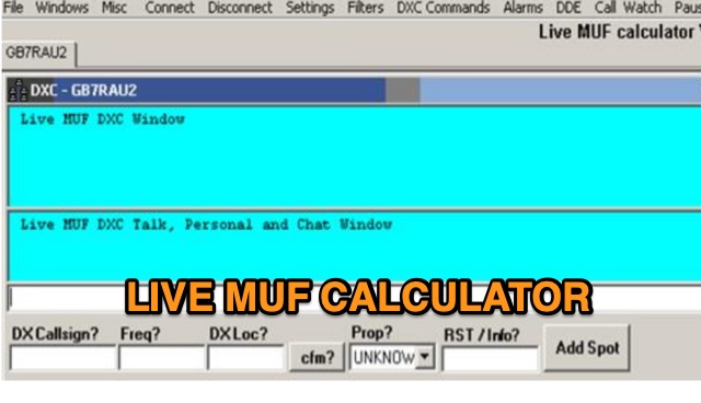 Live MUF is a DXC (cluster) telnet client which attempts to resolve propagation modes from spots and also attempts to calculate sporadic e possibilities purely based on incoming data from the cluster. It has great circle mapping (GCM) built in to the app for live mapping of spots. Live MUF also can be used as a world wide converse telnet client, ON4KST telnet client and DXC at the same time. Live MUF also has basic logging capabilities in case you need an emergency logger at any time.
 -
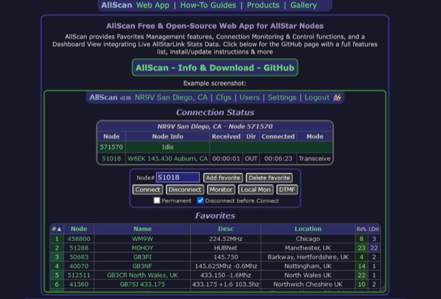 AllScan is a free and open-source web app for AllStar nodes that provides Favorites Management features, AllStarLink Stats integration, and connection monitoring and control functions. Shows your favorites in a Dashboard summary table with Keyed status, Connected Node count and other statistics. Continually scans the status of each favorite using ASL's Stats API data showing which favorites are active and have recently been active. Allows favorites to be connected with a single click (optionally automatically disconnecting any currently connected nodes first). Allows the Favorites Table to be sorted by Node#, Name, Description, Location, etc. Favorites can be added/deleted simply by entering the node# and clicking a button. These features finally give AllStar nodes similar memory management and scan capabilities that analog radios have had for decades. AllScan is mobile-friendly and optimized for ease of use on both small and large screens. AllScan follows the latest web development standards, with PHP, JavaScript, HTML, and CSS cleanly partitioned, runs on both ASL and HamVOIP, and is very easy to install, configure, and update.
 -
 Twigger is a very lightweight, free ham radio logger designed for Windows, offering seamless integration with transceivers via _TCI_ or OmniRig. This software stores all logged contacts in a SQLite database, with the flexibility to export daily ADIF files for import into a main logger or to send real-time QSO data via UDP in N1MM XML format. It also supports direct, real-time uploads to popular online logbooks like Clublog and QRZ.com, streamlining the logging process for active operators. The application has seen continuous development, with version 1.1.34 fixing an ADIF log importer bug and earlier versions adding crucial features like WSJT-X/JTDX UDP support. Author OE3IDE, Ernst, has incorporated user feedback, including ideas and testing from MW0LGE, to refine the software. Key enhancements include the transition to SQLite for data storage in version 1.1.32, allowing for easy import of previous Twigger ADIFs upon initial startup. The logger also features integrated DX cluster support, enabling users to send spots directly and query QRZ.com for callsign information, which is then cached to reduce redundant queries. The software's compact design and essential logging capabilities make it a practical tool for casual logging or as a secondary logger during contests, with the ability to handle **25 downloads** for version 1.1.34.
 -
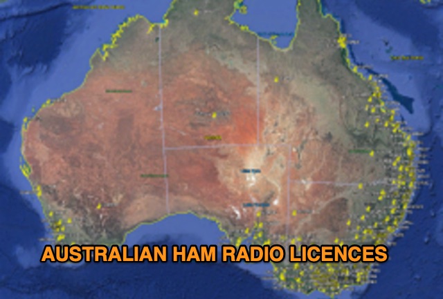 Discover a comprehensive solution for mapping Australian ham radio entities using data from the ACMA Public Register. This tool, developed in Delphi 7, generates KML files for Google Earth, showcasing repeaters, beacons, and operators across different prefixes. While respecting privacy regulations, the files provide valuable insights into the amateur radio landscape.
 -
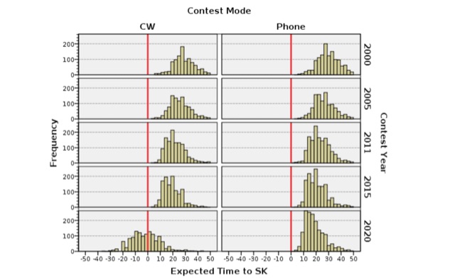 Examining the demographic shifts within amateur radio, particularly concerning **radiosport** participation, this resource analyzes survey data from the National Contest Journal (NCJ) and two regional ARRL surveys. It focuses on the relationship between age and engagement in contesting, presenting findings that suggest older amateur radio operators tend to participate in more contests annually. The author, a spatial demographer, details the methodology, including data consolidation, georeferencing, and statistical analysis performed in collaboration with Dr. Scott Wright K0MD, covering ARRL November Sweepstakes participants from 2000 to 2020. The analysis also addresses the limitations inherent in using voluntary response samples rather than random samples, which may influence the generalizability of the results. Furthermore, the resource investigates the preferred sources of contest information among different age groups, noting that older contesters frequently rely on traditional publications like the NCJ, while younger participants show a preference for online platforms. This demographic review provides insights into the evolving landscape of **amateur radio contesting** and the generational differences in information consumption.
 -
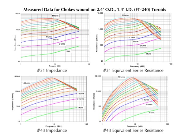 FT-240 toroids measurements. The data was measured using well-calibrated HP instrumentation. All plots have been adjusted to a frequency range of 1-100 MHz on the horizontal axis and a resistance/impedance range of 10-1,000 ohms on the vertical axis. This adjustment facilitates comparison among different materials and aids in determining their suitability for use on the HF ham bands.
 -
 Demonstrates a **Progressive Web App** (PWA) approach to amateur radio logging, providing a platform-agnostic solution for hams. The resource details its core functionality, including offline callsign and reference lookups, auto-formatting for data entry, and integration with **POTA spots** and saved re-spots. It highlights support for various logging templates such as General, Contest, POTA, and Field Day, indicating its adaptability for different operating activities. The application emphasizes seamless log synchronization across multiple devices, eliminating the need for manual file transfers. It operates effectively both online and offline, with installation options available for full offline functionality on Windows, Android, iOS, macOS, and Linux, or direct use within any web browser. The documentation further outlines features like rig control and the continuous development of additional templates, positioning Smart Logger as a flexible and efficient tool for managing amateur radio contacts.
 -
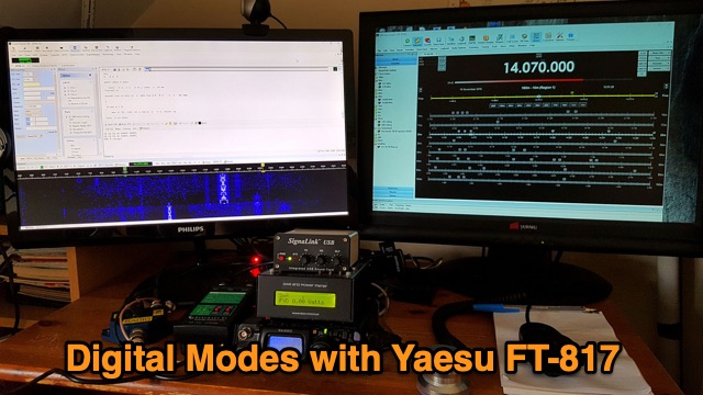 Setting up the Yaesu FT-817 and Signalink for data mode communication. Hardware and software required for data mode communication, connect and configure FT-817 and Signalink