Search results
Query: data
Links: 698 | Categories: 27
Categories
- Technical Reference > Components > Component Database
- Software > Databases
- Technical Reference > Components > Datasheets
- Software > APRS
- Software > Beacon Monitoring
- Ham Radio > Regional > Brazil
- DX Resources > Callsigns
- Technical Reference > Coax Cables and Connectors
- Technical Reference > Components
- DX Resources > Contest > Contest Results
- Operating Modes > D-STAR
- Software > D-STAR
- Antennas > EH
- Operating Aids > Grid Squares
- DX Resources > Log Analysis
- Operating Aids > Log Formats
- DX Resources > Logs Search Services
- Propagation > MUF Indicators
- Operating Modes > NBEMS
- Propagation > Observatories
- Propagation > Propagation Forecast
- DX Resources > QSL manager
- Technical Reference > Repeater
- Operating Modes > Robust Packet
- Operating Modes > System Fusion
- Technical Reference > Vacuum tube
- Antennas > ZS6BKW
-
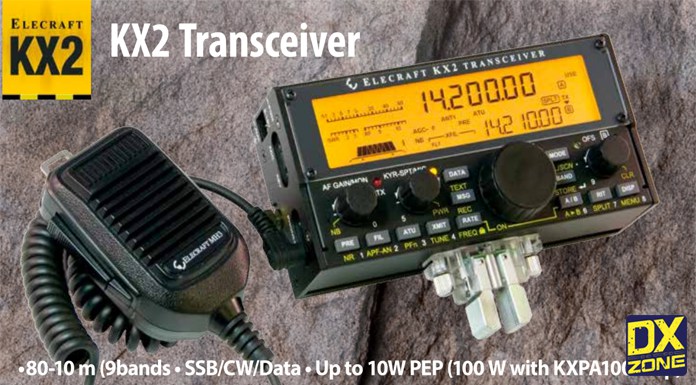 Elecraft new QRP transceiver, an 80-10 m SSB/CW/Data station that fits in your pocket
 -
 This page is devoted to the state of Maryland. It contains links for Trunktracker information and conventional data, along with amateur radio sites
 -
 Data sheets for most of the major components of the K2
 -
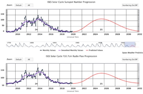 A dynamic graph of current and past solar cycle sunspot number progression and F10.7 cm radio flux progression. In both plots, the black line represents the monthly averaged data and the purple line represents a 13-month weighted, smoothed version of the monthly averaged data.
 -
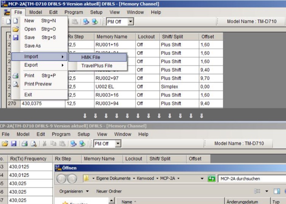 All available frequencies & offsets configurations for repeaters can be downloaded as database for Kenwood MCP-2A memory channel programming software for TM-D710 & TM-V71. Zip file is no more available from the author, but the full table of frequencies is still online
 -
 Design and manufacture antennas for mobile devices, wireless data including WiMAX, WiFi, and WISP (Wireless Internet), two-way radio and RFID (Radio Frequency Identification).
 -
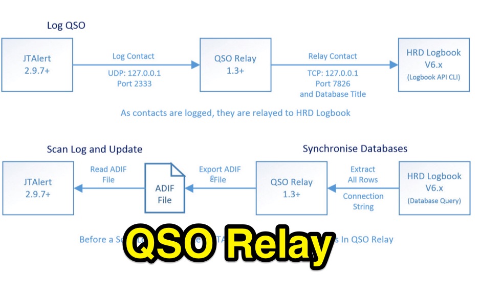 QSO Relay is a Windows desktop application that listens for contacts being forwarded from WSJT-X/JT65-HF and JTAlertX and write to Ham Radio Deluxe Logbook v6.x database
 -
 DxDozer is a Windows-based amateur radio logbook designed for both new and experienced DXers, featuring a robust logging system with extensive search capabilities. It offers seamless integration with FT8, displaying received stations from WSJT-X in a DX Cluster-like view, indicating LoTW status and prior contacts, and initiating QSOs directly. The software supports an unlimited number of callsign logbooks and allows multiple operators to log simultaneously to a single database, enhancing its utility for multi-operator stations or contest operations. The application includes a sophisticated DX Cluster with highly configurable filters based on band, mode, continent, worked/confirmed status, and LoTW participation, enabling users to monitor specific calls or countries. DxDozer simplifies QSL management by facilitating one-button uploads to LoTW and ClubLog, and downloads of new confirmed QSOs, with a dedicated field for QSL medium. The software provides both 'Easy' and 'Expert' modes to cater to different user proficiency levels, and is available via a yearly subscription after an initial free trial period.
 -
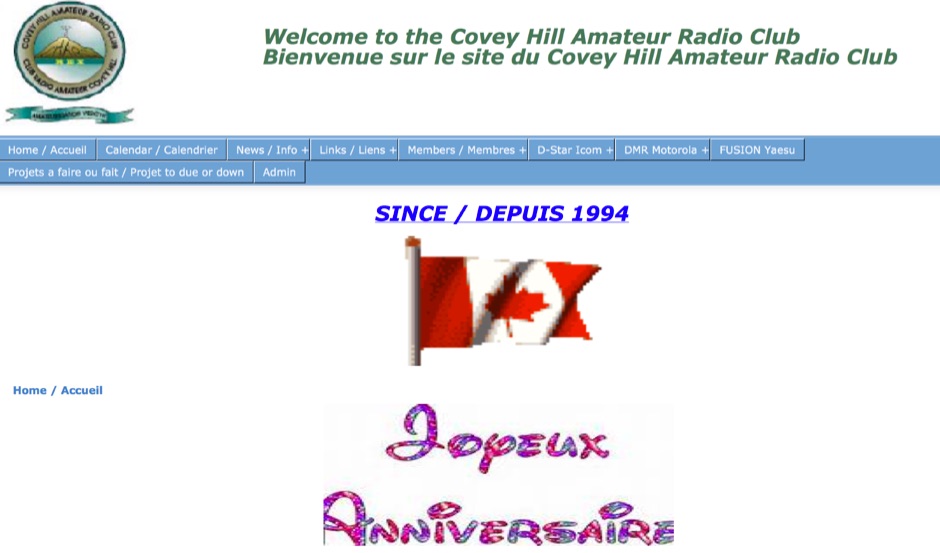 The Covey Hill Amateur Radio Club operates a 146.685 MHz analog repeater with an 88.5 Hz PL tone, alongside several digital repeaters. The resource details specific frequencies and modes for D-STAR (145.590 MHz, 1266.300 MHz voice, 1297.675 MHz data on 23 cm), DMR-Marc (448.525 MHz), DMR-Brandmeister (441.750 MHz), Yaesu Fusion (449.725 MHz), and P-25 Digital (147.315 MHz). It also lists Echolink node 595040 (VE2REX-R) as an access point for the club's network. A recent update, dated June 19, 2024, announces the VE2REX analog repeater and Echolink are fully functional again, after resolving issues including a conflicting 100.0 Hz tone, software repairs for Allstar and Echolink, a suspected defective USB port on the Mini PC, and a faulty exciter in the Motorola Quantar repeater. Guy, VE2VMT, was instrumental in troubleshooting these problems. The club, established in 1994, provides a calendar, news, links, and membership information, with Linda Cullen, VE2NJK, serving as president and VA2DBJ as webmaster.
 -
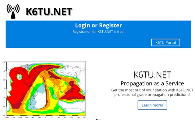 Get the most out of your station with K6TU.NET professional grade propagation prediction, and model your antenna performance over actual terrain using high resolution elevation data
 -
 Time Mapper UHD is a versatile mapping and time visualization program offering multi-satellite viewing with frequency display and unique country-pairs for PskReporter data. It features live feeds from logging programs and can plot ADIF files. Ideal for schools, offices, or amateur radio stations, it provides customizable 4K or HD world clock displays with over 60 map layers, including ham radio zones and natural features. The program supports various time functions and can import logs for detailed analysis. It runs on Windows 10 or 11 and offers a 30-day free trial.
 -
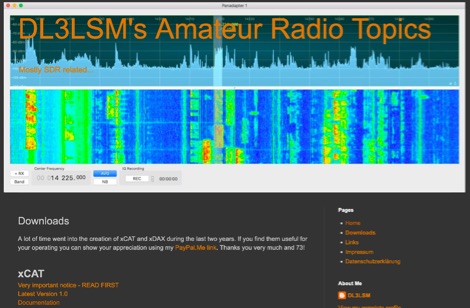 xCAT is an helper application for the FlexRadio 6000 series running on macOS computers to control via CAT protocol tranceivers, while xDAX purpose is to provide a way for Digital Mode Software like Fldigi, WSJT-X to access the digital audio data (DAX) of the FlexRadioTM
 -
 Small company based in Santa Maria, California, designing and manufacturing electronic products for amateur radio, education, and commercial users. Product line includes APRS devices for real-time vehicle tracking, weather monitoring, and remote telemetry, as well as the ADS-SR1 Simplex Repeater, the ADS-WS1 Weather Station, the SSTVCAM slow-scan TV camera, and GTRANS protocol translator for Garmin FMI.
 -
 Accessing current operational statistics for a DXpedition is crucial for DXers planning their next contact. This Club Log page provides a detailed, real-time overview of the 3Y0J Bouvet Island operation, a highly sought-after DXCC entity. It presents a dynamic dashboard showing total QSOs, unique calls worked, and duplicate contacts, all updated as logs are uploaded from the remote location. Users can observe the expedition's progress and strategize their operating times. The interface features interactive charts and graphs, allowing operators to analyze the _3Y0J_ log data by band and mode, including CW, FT8, and SSB. A breakdown of QSOs by continent provides insight into propagation patterns and where the expedition has focused its efforts. The page also includes a map for checking real-time propagation conditions to Bouvet Island, which is invaluable for optimizing contact attempts. Further details include the first and last QSO times, total operating days, and the impact on users' DXCC totals, such as new bands, modes, or DXCC entities worked. This resource is a vital tool for the DX community, offering transparency and actionable intelligence for chasing one of the rarest entities on the air.
 -
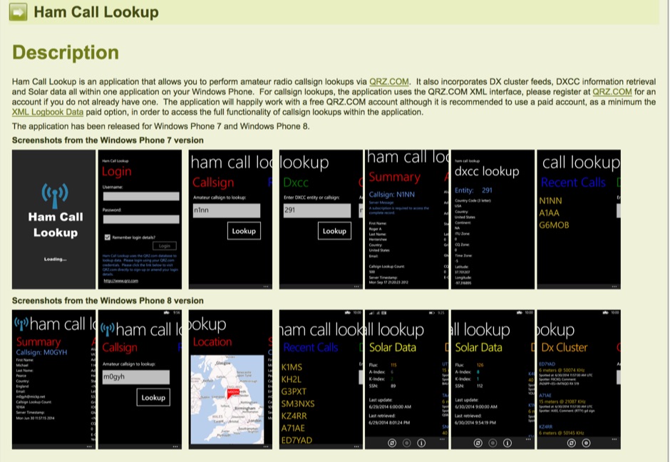 Ham Call Lookup is an windows phone app that allows you to perform amateur radio callsign lookups via QRZ.COM. It also incorporates DX cluster feeds, DXCC information retrieval and Solar data all within one application on your Windows Phone. For callsign lookups, the application uses the QRZ.COM XML interface, please register at QRZ.COM for an account if you do not already have one. The application will happily work with a free QRZ.COM account although it is recommended to use a paid account, as a minimum the XML Logbook Data paid option, in order to access the full functionality of callsign lookups within the application.
 -
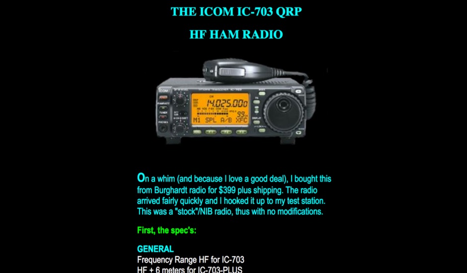 A review with early observations and technical data specifications of the Icom IC-703 QRP HF+50 MHz transceiver
 -
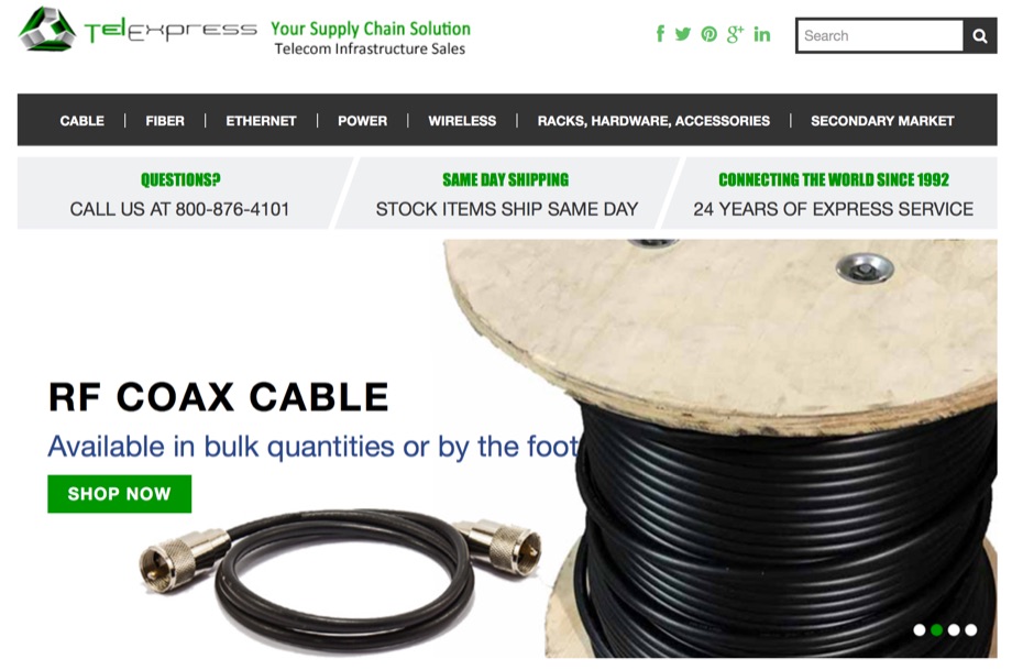 TelExpress provides a wide array of RF and data connectivity products, including various coaxial cables like LMR-series equivalents, fiber optic cables, and Ethernet solutions. Their inventory supports diverse amateur radio and telecommunications requirements, from antenna feedlines to network infrastructure. The site emphasizes bulk cable availability and custom assembly services, catering to both individual hams and larger installations. Key offerings include _low-loss coax_ for HF and VHF/UHF applications, along with a comprehensive selection of RF connectors. They also supply patch panels, Ethernet cables (Cat5e/Cat6), and general wireless and telecom hardware. Customers can find components for building robust station infrastructure, ensuring signal integrity across various frequency bands. The platform facilitates procurement of essential parts for new builds or upgrades, supporting reliable RF system performance.
 -
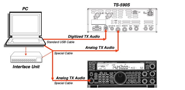 This HOWTO explains in detail how you can use the Kenwood TS-590S USB, COM and ACC2 ports for digital operation, set up the radio for digital data and digital voice operation
 -
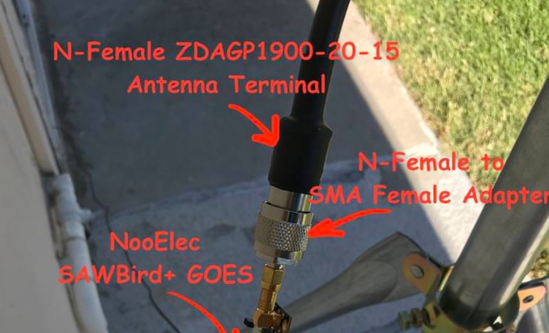 Receiving **GOES-16** and **GOES-17** weather satellite imagery requires a specific hardware and software configuration, detailed in this practical guide. The author outlines the necessary components, including a Raspberry Pi, an RTL-SDR dongle, a suitable LNA with SAW filter for 1.69 GHz, and a parabolic grid antenna. This setup enables direct reception of high-resolution weather data, a fascinating aspect of amateur radio satellite operations. The installation process begins with preparing the Raspberry Pi, followed by updating the system and installing essential dependencies like `git`, `build-essential`, and `cmake`. A critical step involves compiling and installing `librtlsdr` from source, ensuring proper driver setup and blacklisting conflicting DVB drivers. The guide then walks through testing the RTL-SDR dongle to confirm device recognition and troubleshoot common issues like USB power or driver installation problems. Finally, the instructions cover cloning and building `goestools`, a software suite essential for processing the satellite signals. This compilation, while time-consuming on a Raspberry Pi, is crucial for decoding the raw data into usable imagery. The guide concludes with the initial steps for creating the `goesrecv.conf` configuration file, preparing the system for active satellite reception.
 -
 First released in 1988, _SWLog_ is a comprehensive suite of applications providing logging and remote control for both amateur radio and shortwave, utility, and broadcast listening. It integrates program schedules from sources like _HFCC_, _ILGRadio_, and _EiBi_ for broadcast reception, while also linking with amateur radio logbooks such as _ClubLog_, _eQSL_, _QRZ_, and _LoTW_. The software supports radio control for various transceivers, including _Flex_, Icom, Yaesu, and Kenwood, alongside interfaces like _FLRig_, _OmniRig_, and _HamLib_. Mobile applications for Android and iOS facilitate on-the-go logging and remote control, seamlessly transferring logs without manual ADIF export. _SWLog_ leverages an enterprise-grade relational database (SQL Server) for robust data management and analytics, enabling features like mapping QSOs by band or state. It offers specific integrations for _POTA_ monitoring, displaying active spots with real-time propagation and automatic radio tuning. The application's scalability allows multiple users to log to a centralized database, suitable for Field Day or DXpeditions. The user interface features modern aesthetics with light, dark, and gray themes, the latter optimized for outdoor visibility during activities like _POTA_ or _SOTA_. The Plus Edition, available for an annual fee, expands capabilities with advanced QSL integration, additional map providers, and enhanced propagation calculations using _VOACAP_.
 -
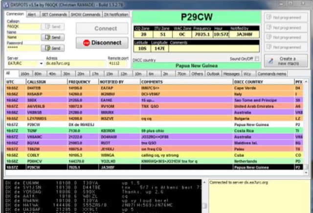 DXSPOTS is a Telnet connection program. It allows radio amateurs with a lot of DX traffic to know instantly the status of the bands and to know which DX are currently on the air. Following the Packet-Clusters where data was transmitted on VHF/UHF via dedicated relays and sometimes on HF at a very low speed (300Bds on HF), the Internet has taken over and is now transmitting DX information via the computers in most shacks. Translated with www.DeepL.com/Translator (free version)
 -
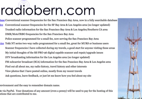 Conventional scanner frequencies for the San Francisco Bay Area, now in a fully searchable database
 -
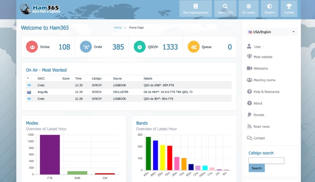 Over 15 years of continuous operation, Ham365 provides a web-based logging solution for Amateur Radio Operators, allowing them to maintain and share their QSO records online. Originally launched as the online logbook component of Ham Radio Deluxe, it has since evolved into an independent platform, now integrating with numerous other logging applications. The platform shares its database with HRDLOG.net, ensuring that operations performed on one site are reflected on the other, maintaining data consistency for users. Key features include an overview of the latest hour's activity, a display of the most recent QSOs, and a map visualizing recent contacts. It also highlights "Most Wanted" entities and ongoing DXpeditions, providing a dynamic view of current amateur radio activity. The logbook supports various operating modes, including SSB, RTTY, PSK31, and FT8, and handles ADIF data for interoperability. Users can manage their logbooks, track DX activity, and utilize features like OQRS (Online QSL Request System) through its integrated functionalities. The system is designed to be accessible to a wide range of operators, from casual ragchewers to avid DXers and contesters.
 -
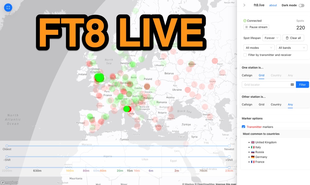 Visualizes real-time amateur radio propagation spots using data from the PSK Reporter MQTT stream, providing immediate situational awareness for radio operators. The platform displays spots from various modes, including CW, WSPR, and JT65, in addition to the dominant FT8 digital protocol. FT8 Live focuses exclusively on live data streams, prioritizing current signal activity over historical archiving, which differentiates it from the official PSK Reporter map. A key feature is its integration with the Summits on the Air (SOTA) API, facilitating SOTA chasing by cross-referencing transmitting callsigns with SOTA alerts; a station is identified as an activator if the spot correlates with a scheduled alert within an eight-hour window. The user interface was developed by Arron (ZL1AN), with core data from Philip Gladstone (N1DQ), and stream delivery managed by Tom Stanton (M0LTE).
 -
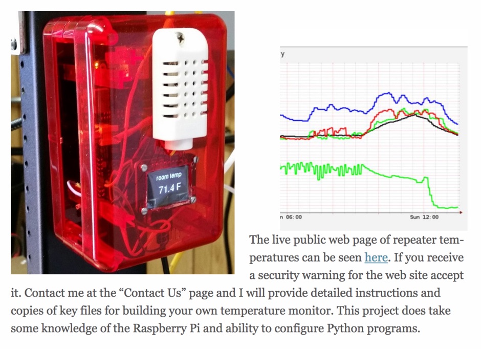 A simple and cheap solution to monitor temperature of your repeater implementing a Raspberry Pi device with a set of popular tools made in python a database and RRD tool
 -
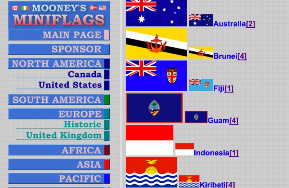 A website with a large collection of world flags pictures in GIF format divided per continent. Includes flags of US and Canada states
 -
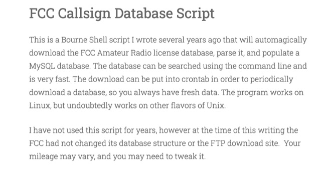 This is a Bourne Shell script that will automagically download the FCC Amateur Radio license database, parse it, and populate a MySQL database. The database can be searched using the command line and is very fast.
 -
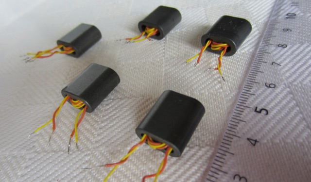 Operating within the low-frequency spectrum, transformers serve critical roles in antenna systems, particularly for 160m applications. The resource details the construction and performance of 1:1 transformers built on BN-73-202 cores, emphasizing their use as hybrid combiners or phase inverters for RX antenna arrays. Measurements reveal that these transformers exhibit minimal losses, around 0.12 dB at 1.8 MHz, with variations based on wire type and number of turns. The analysis includes comparative data on transformer performance, highlighting the impact of different winding techniques on frequency response. Notably, the use of coaxial cable for winding improves bandwidth while maintaining low-frequency efficiency. The resource also discusses braid breaker transformers, which minimize inter-winding capacitance, achieving low losses around 0.21 dB at 1.8 MHz. These insights are crucial for optimizing low-band antenna systems, allowing operators to make informed decisions regarding transformer design and implementation.
 -
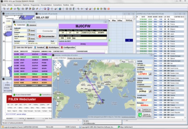 DXFile is a Windows shareware application designed for amateur radio operators, providing comprehensive log management capabilities. The software, developed in Pascal, facilitates real-time and deferred QSO entry, automatically populating fields like frequency, mode, and DXCC country based on user input and system time. It includes features for searching, modifying, and deleting QSO records, with options to sort logs by date, callsign, or entry order. The program offers various printing functions, including QSL card labels in multiple formats, and can generate standard logbook printouts. Beyond basic logging, DXFile integrates modules for tracking progress towards major operating awards such as DXCC, _IOTA_, WAZ, WAS, DDFM, and DIFM. It provides detailed summaries of contacts by band and mode, including graphical representations of HF traffic. A dedicated QSL Manager module assists in processing received QSLs, allowing users to mark confirmations and print multi-line QSL labels. The application also incorporates a DXCC list viewer, which can be updated to ensure accurate country and zone data for logging and award tracking. A distinctive feature is its HF propagation prediction module, which calculates optimal frequencies and signal levels for paths between **250 km** and **6000 km**, considering both E and F layer ionospheric conditions. This module helps operators determine the best times for long-distance contacts. Additionally, DXFile includes a _Web-Cluster_ interface, enabling connection to various DX cluster servers like DXLITE, DXSCAPE, and NC7J for real-time spot information.
 -
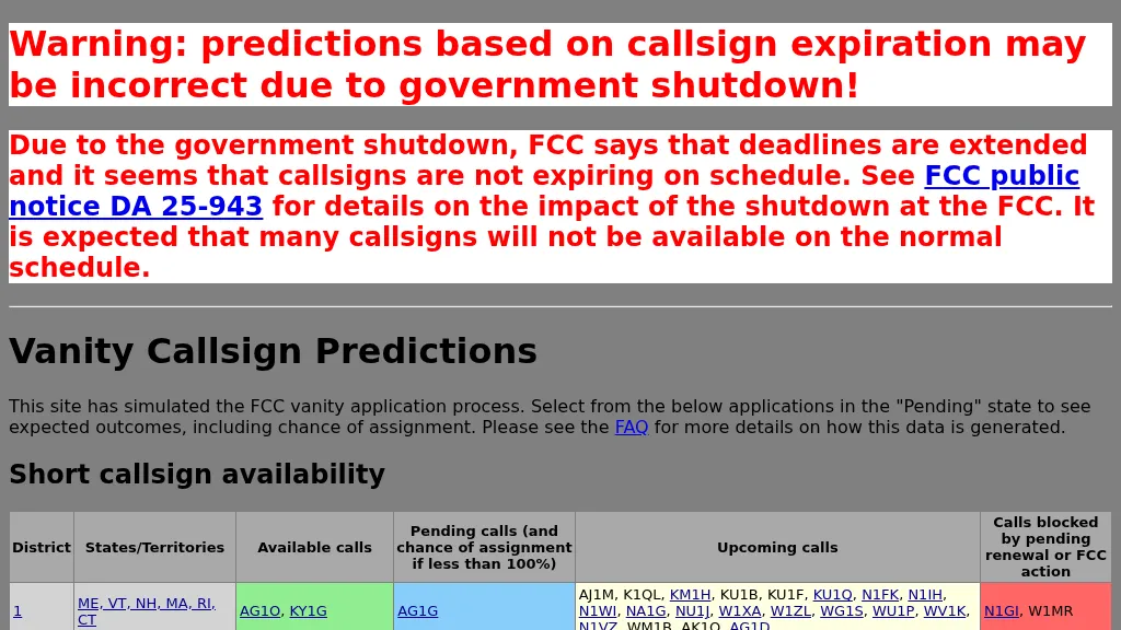 Over 100 FCC districts are analyzed by this resource, providing a predictive database for amateur radio vanity callsign assignments. The system simulates the FCC's application process, calculating the probability of assignment for specific callsigns, such as KD3Q at 94% or N9QC at 97.8%. Data is meticulously organized by FCC district, detailing available, pending, and upcoming callsigns, alongside those currently blocked by renewal or other FCC administrative actions. This allows hams to gauge their chances of securing a desired callsign. The database presents specific application entries, including the date entered, receipt date, process date, the applicant's current callsign, and the vanity callsigns they have applied for. Each entry facilitates examination of predicted outcomes, which categorize potential assignments as assigned, competitive, non-assigned, unneeded, curable, or unknown status. For instance, an application for K7DM clearly shows multiple applicants, indicating a highly competitive assignment scenario. This tool is particularly useful for those seeking a **short callsign** or a **1x2, 2x1, 2x2, 1x3, 2x3, 3x1, 3x2, or 3x3 callsign** that aligns with personal preferences or contest aspirations. It provides a clear, data-driven perspective on the likelihood of obtaining a specific vanity callsign.
 -
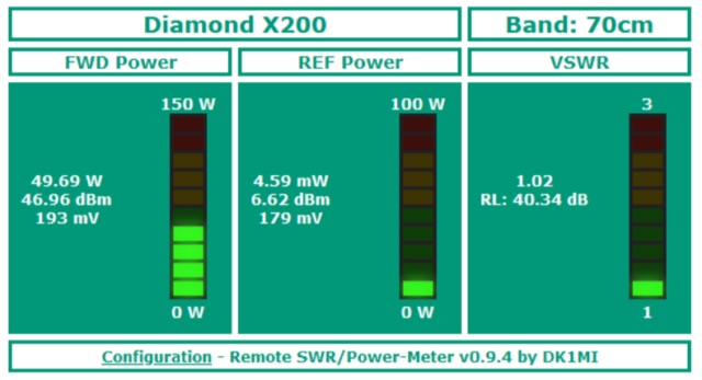 Remotely monitor the output power and SWR of your station via a web browser. WT32/ESP32 based project, combined with a directional coupler setup. It reads two voltages which are supplied by the directional couplers. From these, the respective power is calculated with the help of a calibration data table to be created by the user.
 -
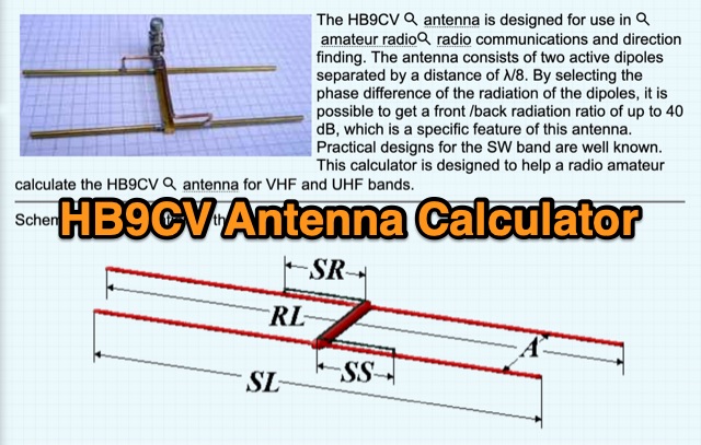 The HB9CV antenna calculator aids amateur radio enthusiasts in designing antennas for VHF and UHF bands. By inputting the working frequency, users can obtain crucial dimensions like dipole lengths and distances. The tool, based on the HFSS antenna model, provides data on impedance, VSWR, and gain, optimizing front/back radiation ratios. It includes tips for fine-tuning using a Г-matching balun and compensating capacitor, ensuring effective performance and minimal VSWR for enhanced radio communications and direction finding.
 -
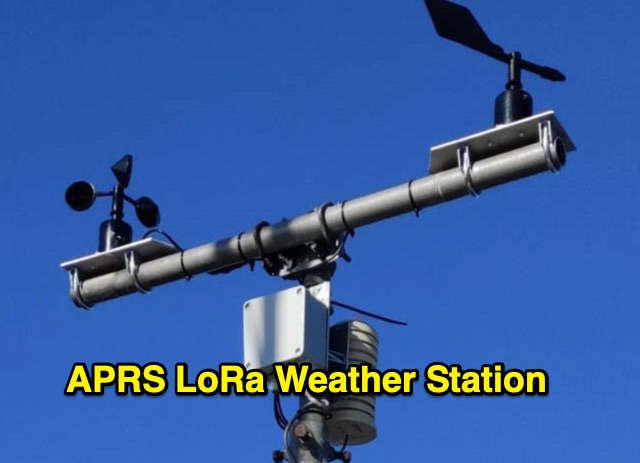 The weather station described here uses a TTGO v3 1.6.2 module and various sensors. It displays the data on an OLED screen and transmits them among a choice of protocols to the APRS, APRS-IS, Wunderground servers or via an MQTT broker. APRS data is transmitted on 433.775 MHz (can be changed) using the LoRa protocol. APRS beacons picked up by iGate gateways are then transmitted to APRS servers.
 -
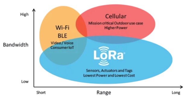 About LoRa, wireless communication technology designed to transmit data over long distances. LoRa provides a means for wireless data transmission over long distances with low power consumption. Practical applications of LoRa in amateur radio
 -
 MLog 0.8d is a freeware logging software designed for Windows operating systems (NT, 98, ME, 2000, XP) that facilitates the logging, management, and analysis of amateur radio QSOs. It features a customizable input mask for rapid contest logging, a robust search function for existing contacts, and immediate data storage in CSV format to prevent data loss. The software also includes a double-check mechanism against reference logs during callsign entry, integrated DXCC information, and a "magic field" for streamlined data input, all within a single-window interface. Key functionalities include graphical QSL card management via _QSL-Collection_, CW output through soundcard or PC speaker, and direct access to _Radio Amateur Callbook_ data. MLog supports transceiver control via _Ham Radio Deluxe_ URLs, offers a detailed world map with locator conversions, and can launch _VOACAP_ through _HamCap_. It provides extensive data analysis options for QSLs, _Locator_ large fields, _DOKs_, _DXCCs_, QSO counts, and user-defined contest evaluations, alongside flexible import/export capabilities for various log formats.
 -
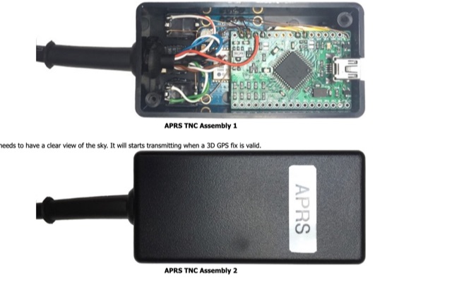 A basic introductionto APRS on HF Bands for radioamateurs and how to setup an APRS tracker using Argent Data Systems T3 Mini TNC device, configured and assemble ready for portable operations.
 -
 A collection of dynamically produced images based on the daily data of the NOAA Space Weather Prediction Center
 -
 The HF Beacon Tracker is an advanced interactive tool designed for DXers and ham radio opoerators in general to monitor active beacons operating below 14 MHz. Built upon a high-fidelity 3D Earth globe, the application provides a spatial perspective on signal paths by integrating real-time environmental data with a comprehensive beacon database curated by Mirek OK1DUB. Beacons are plotted using precise Maidenhead locators and feature a real-time day/night terminator overlay to help operators identify Gray Line propagation opportunities. With a single click, users can calculate the exact distance from their own QTH to any beacon, visualized via an animated Great-Circle Path arc on the globe surface. To enhance its diagnostic capabilities, the tool seamlessly integrates with PSK Reporter, allowing users to right-click CW beacons to instantly fetch current reception reports and signal strength data. The interface is fully optimized with a mobile-responsive design, smooth globe rotation, and togglable Dark/Light themes suitable for any shack environment. Whether you are performing antenna gain tests, conducting ionospheric research, or simply hunting for band openings, the HF Beacon Tracker transforms raw database information into an intuitive, visual diagnostic suite. It serves as an essential asset for any operator looking to master HF band conditions.
 -
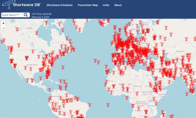 Worldwide Map of shortwave transmitters. Based on shortwave schedule database, this website let you serarch using filters for broadcasts schedule and at the same time to diplay the transmitter map.
 -
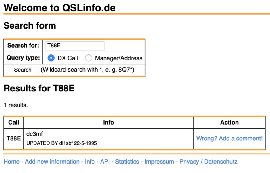 QSLinfo.de is a QSL manager and address database for radio amateurs, maintained by Lothar, DL1SBF for more than 25 years already.
 -
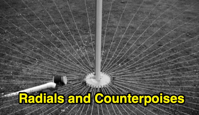 Steve Nichols, G0KYA, presents a practical examination of ground systems for vertical antennas, drawing heavily on the empirical research of Rudy Severns, N6LF. He explains that a robust radial field is crucial for ground-dependent verticals, effectively replacing the antenna's "missing half" and mitigating severe RF absorption in lossy soil. Nichols clarifies that surface radials do not strictly require a quarter-wavelength; instead, deploying a minimum of 16 to 32 shorter wires often yields superior results compared to fewer, longer ones. The presentation also addresses the common SWR paradox: a poor ground might show a perfect 1:1 match, but adding radials, while potentially raising the SWR to around 1.4:1, significantly improves true radiation efficiency. Nichols defines counterpoises as elevated wire networks that substitute for earth connections, offering solutions for limited-space installations, such as the **Folded Counterpoise (FCP)** for 160 meters. This resource provides actionable engineering data for optimizing vertical antenna performance.
 -
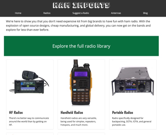 The database of Chinese ham radios. We are here to show you that you do not need expensive kit from big brands to have fun with ham radio. With the explosion of open source designs, cheap manufacturing, and global delivery, you can now get on the bands and explore for less than ever before.
 -
 Hamradio_copilot is an open-source tool designed for DXers and contesters who need real-time situational awareness. It is ideal for operators who want to visualize propagation trends instantly rather than scrolling through raw text streams of cluster spots. Rally acting as a copilot for your station, this tool transforms raw data into actionable intelligence. By visualizing Signal-to-Noise Ratios (SNR) across different bands, it helps operators make quick decisions on which band to prioritize or where to point their antennas, effectively showing not just who is on air, but where the propagation is currently open from your location. This is a fantastic information for avid contesters. The software aggregates data from two primary services: - Reverse Beacon Network (RBN) via Telnet. - PSK Reporter via MQTT feeds. It processes this data to generate a comprehensive HTML report featuring SNR heatmaps and statistical breakdowns by ITU Zone. Users can filter data by specific zones or country codes (ADIF), analyze historic time ranges, and optionally integrate solar weather data. The complete source code is available on GitHub, allowing for community customization. It is written in Python and uses SQLite for data management.
 -
 KlaTrack is a Windows-based software application designed to assist amateur radio operators with satellite communication by predicting spacecraft visibility. It provides a simple interface to determine when specific satellites will be above the local horizon, a critical factor for successful two-way contacts via amateur radio satellites. The program processes _Two-Line Element_ (TLE) data to calculate orbital mechanics, offering a practical tool for satellite operators to plan their operating windows. It supports real-time tracking and displays essential pass information. This utility simplifies the complex task of satellite tracking, allowing operators to focus on making contacts rather than manual orbital calculations. While specific gain figures or distances are not quantified, the software's core function directly supports achieving successful satellite QSOs by providing precise pass predictions. It is particularly useful for operators engaging in activities like working the International Space Station (ISS) or other low-Earth orbit (LEO) satellites, where short pass times and precise timing are crucial for maximizing contact opportunities.
 -
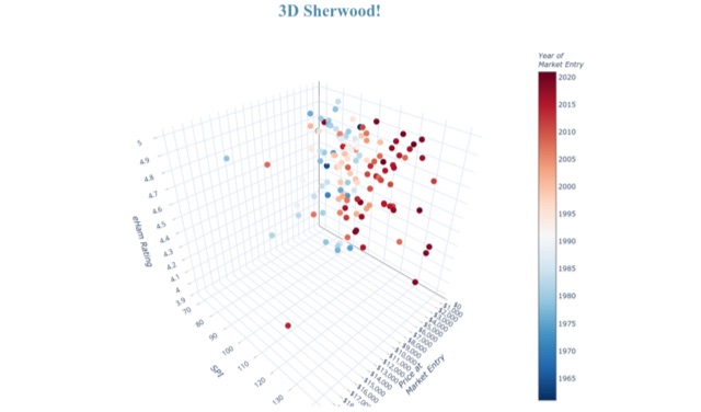 A growing set of pages with tools and analyses of various elements of data elements based on Sherwood RX tests
 -
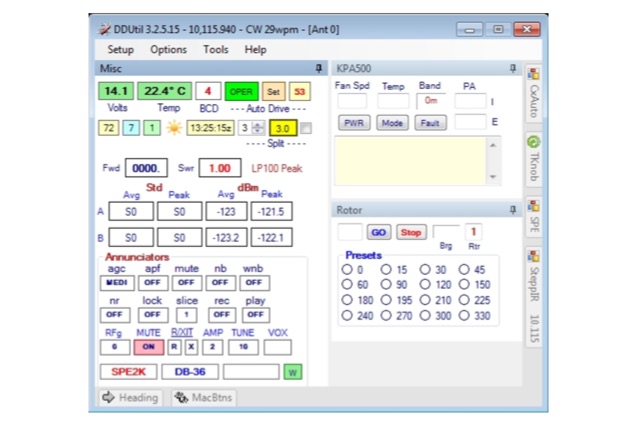 Data Decoder Utility is designed to enhance the operating experience for Flex Radio users by providing advanced connectivity to Peripheral equipment and radio control programs (RCPs) otherwise not available.
 -
 An online database featuring current and historical weather balloons, complete with a fully searchable archive that can be filtered by launch site. The integrated map shows both the current and historical trajectories of radiosondes, from their launch points to their final landing positions.
 -
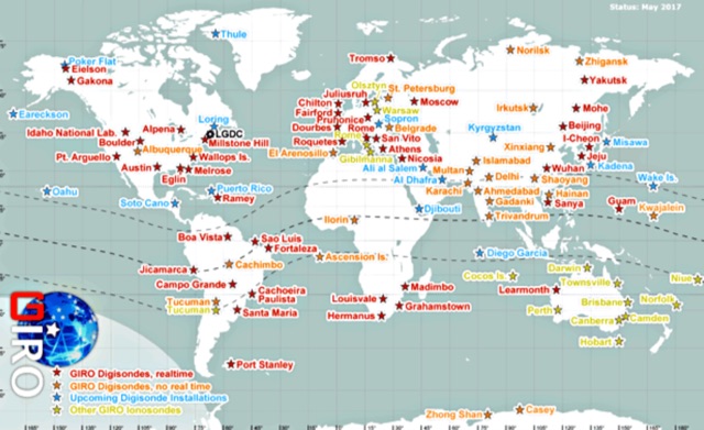 In cooperation with the URSI Ionosonde Network Advisory Group (INAG), the LGDC promotes cooperative agreements with the ionosonde observatories of the world to accept and process real-time data of HF radio monitoring of the ionosphere, and to promote a variety of investigations that benefit from the global-scale, prompt, detailed, and accurate descriptions of the ionospheric variability.
 -
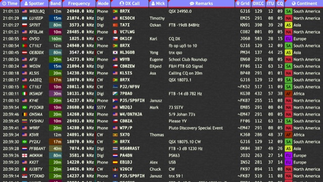 Over 15 amateur radio bands, from 160m to 70cm, are supported by the _DXTRON_ web cluster, providing real-time DX spotting information. This service integrates directly with the _QRZCQ_ API, allowing users to monitor activity across various modes including CW, Phone, Digi, RTTY, SSTV, and SAT. DXTRON displays critical spot data such as timestamp, spotter callsign, frequency, mode, DX call, and remarks, along with geographical details like Grid, DXCC, ITU, CQ zone, continent, and country. Developed by _DO5SSB_, DXTRON v1.42 offers a user-friendly interface for filtering spots by band and mode, catering to both casual DXers and serious contesters. The platform is designed for accessibility, providing a clear overview of current propagation conditions and active stations worldwide. This web cluster is a practical tool for hams seeking to identify rare DX, track contest activity, or simply observe band conditions. Its reliance on the QRZCQ API ensures a consistent flow of up-to-date spotting data, making it a reliable resource for real-time operational awareness.
 -
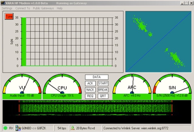 VARA HF is a soundcard modem that can be found on the HF bands exchanging traffic (Winlink). VARA implements an High Speed Data Mode and comes in 2 separate programs VARA FM and VARA HF. VARA is a High Performance HF modem based on OFDM modulation. VARA Modem, brings state of the art Military grade technology to new and existing HF data. Introduces a new standard of technology available for Amateur and Commercial use. Designed for operation within a SSB Bandwidth of 2400 Hz.